Alta Via 5

Alta Via 5. Day One. Pian de Fiscalina to Bivacco Toni. 12 Km 5 Hrs. 1200m Up 250m Down. I managed to fluently link up the 3 buses from Venice to Cortina D’Ampezzo, then Dobbiaco and finally Pian de Fiscalina, just after Sesto. It took me just 5 hours from 0800 until 1300 to reach the start of the Alta Via Five (AV5). The start was at the end of the valley road by a huge parking place, half full of campervans and sensible cars. There was a restaurant here but it was busy with day trippers and I was keen to get started and see if there were any problems with my rucksack, packing or even me, and knew there was another restaurant 2 km up the trail. The first meters were as always a delight in the Dolomites, the heavy weekend rains had passed and the sun was out and the sharp peaks beckoned, drawing me up the white gravel path between the pines. The trail was busy with families, older couples, cyclists and groups and there seemed no hint of any covid crisis. After half an hour I reached the Rifugio Fondovalle and everything felt great. I stopped here for bread and cheese. However what was once a simple refugio had now become much more sophisticated and I had to have a couple of fancy open sandwiches and side salad. The other diners were enjoying fine meals and for the most of them it was the reason for the walk from the car park just down the valley. There were very few rucksacks here.
After lunch I set off up the trail into the higher valley, leaving the day trippers behind. Almost at once the trail became quiet with just groups returning from higher up with rugged boots and small rucksacks. Everybody now greeted me with the “Guss Got” is they were Germanic or “Bueno Sera” if Italian, for the South Tyrol is a bilingual area. I felt very fit and powered up the trail climbing quickly towards the Rifugio Comici. I climbed the 700 metres in 90 minutes without really breaking sweat. The promise of the high valleys surrounded by impossible dolomite towers and spires spurred me on and I was soon welcomed into a high stoney valley above the tree line dominated by the looming tower of Croda dei Toni.
When I reached Rifugio Comici I had a choice of 3 routes. A each jaunt over the pass to Refugio Carducci in perhaps an hour. A demanding route round Croda dei Toni which would take 6 hours with a night in a small metal shed called Bivacco de Toni and some Via Ferrata the next day. Finally there was the 2 day hike up and over Croda Rossa with a night at Refugio Berti and some Via Ferrata on both days. The first was too easy and the second too time consuming so I chose the option to Bivacco Toni.
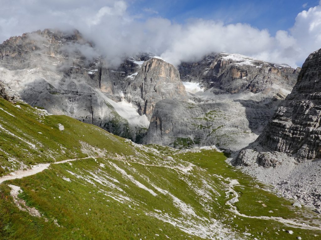
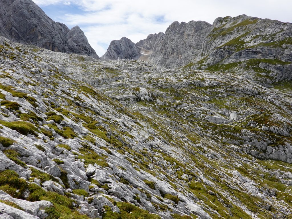
01. Looking back on the climb up to Passo Fiscalino with Rifugio Comici out of sight just beyond the grassy slopes and Monte Popera across the valley
It was still 4 hours away and I needed to get there tonight so I did not stop at Rifugio Comici but continued on up for another 300 metres to Passo Fiscalino. It was delightful walking across green pastures full of wild flowers and outcrops. There were fantastic views in all directions but especially to the south and east where enormous spires dominated. At the top of the pass a tremendous vista to the west burst upon me. Beyond the steep green alpine valleys, some with lakes, rose The Tre Cimes de Levaredo, perhaps the most iconic mountain of the Dolomites. I was just seeing them end-on along this jagged ridge, so I could only see one of the spires and not all three. In the distance was the Sorapiss Massif, perhaps my favourite mountain in the Dolomites and beside it was the entire North side of the remote Marmarole massif where I would be spending at least half my 6-7 days on the AV5.
02. Looking west from near Passo Fiscalino over Lago de Cengia and on towards the Tre Cimes de Lavaredo which is seen end on and not in its full glory
There was a rough steep short cut west of the Passo Fiscalino down to the path which I would follow for the rest of the day. I took it to avoid the short detour up to Refugio Pian di Cengia, where I could also have spent the night. Once on the main path, number 107, it was a pleasant 2 hour jaunt on the west side of Croda dei Toni beneath its massive west face which loomed up above me. The path was as level as you get in the Dolomites, but still involved some difficulties. However the glow of the evening sun and the tenacious alpines, especially the harebells, and numerous saxifrage species more than compensated.
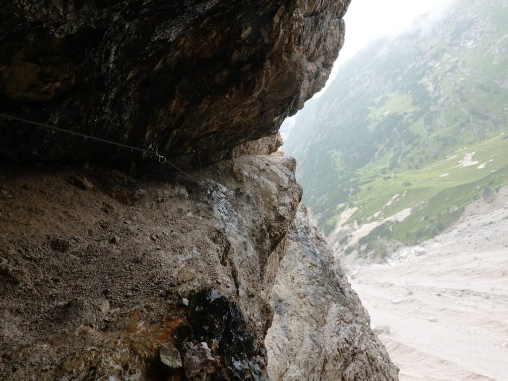
Just some 2 km before the Forcella (pass) de L’Agnel and the Bivacco Toni was a tricky section with metal cables and loose stone. My climbing equipment was buried in the rucksack so I decided to push on without it but it was a tad risky. One 5 metre section was very steep and awkward to downclimb. To make it worse there was a steep snowfield at the bottom with hard packed snow so I had to kick steps for 5 minutes to cross it. The final slopes up to the pass were steep and loose and sapped my remaining strength which had been greatly diminished by the sort via ferrata section.

03. The small red shed is the Bivacco Toni which sits at nearly 2600m in a saddle on the south side of the Croda dei Toni massif.
At the top of the pass I could look down the V shaped slot of Val Gravasecca between the mountains of Cima d’ Auronzo and Punta de l’Agnel. It looked impassable and foreboding it was so deep and inhospitable. Instead I would have to traverse round the south flank of Cima d’ Auronzo on the infamous Via Ferrata San Casara. However, just below the pass was the stark Bivacco Toni, a small red metal shed into which 9 beds were crammed in 3 layers of sardine-like bunks. I opened the stable door and closed the lower half and folded the top 6 bunks towards the sides to give more space and then unpacked. What a view there was through the top half of the door down the chasm of Val Gravasecco and mountains beyond. There was a dribble of water nearby but this would certainly be dry after a few days of clement weather. I had just settled in when a young Slovenian couple arrived. We reconfigured the bunks so they could slot in also. Thankfully no one else showed up that evening otherwise it would be cramped.

04. The view from the door of Bivacco Toni at looking down the impassable and hostile valley Val Gravasecca. The route from here goes across the cliffs to the left on the Via Feratta San Casara skirting the south face of Croda dei Toni
Alta Via 5. Day Two. Bivacco Toni to Ligonto. 14 Km. 6.5 hrs. 180m up. 1990m down. It snowed in the night and the Slovenian couple who wanted to leave at 0400 left at 0700 by which time it was clearing up. The whole mountain looked very dramatic with mist behind each peak silhouetting it and the valley below full of cloud. I left later at 0900 after a nice slumber. As I ate breakfast I could just make out the Slovenians on an exposed ridge far down the mountain. Initially the rough path went down the north side of the great stone chute until it reached a horizontal ledge on the south east face of Cima d’ Auronzo where the Via Ferrata San Casara started. I was delighted to see it had newly been refurbished with new anchor points and a shiny new cable which was taut. I clipped onto the cable and started along the ledge with one hand to steady myself on the cable. It was not a particularly difficult via ferrata and being quite dry allowed my boots to feel solid on the sharp jagged dolomite rock. There was the odd section where I had to lean back over an abyss with my hands on the cable keeping me from falling backwards. At each anchor point I would move the carabines attached to my harness by slings past the anchor, one at a time, so I was always attached. After an hour I heard voices and met 4 Germans coming up a steep section. I waited for them so as not to dislodge small stones onto them.

05. The rock face on the south of Croda dei Toni massif where the Via Feratta San Casara goes. Just above the mist in the centre of the photo is a rare section of path with two tiny climbers on it.
The Germans had come from Refugio Carducci and said they had taken 2 hours. I was pleasantly surprised as I thought the whole journey time was 4 hours. After the long steep descent after meeting the Germans the mists returned and enveloped everything so my limited view was now hidden. Perhaps it was a good thing as the tremendous exposure, often 100 metres or more vertically down from the narrow ledges I was on, was obscured. A little later the mountain was riven by a vast chasm of Biblical proportions, but just 10 metres wide. Thankfully there was a wire bridge here to spam the chasm otherwise the detour would have been fearsome. From the middle of the bridge I could see the sides of the cleft disappear down into the mist 200 metres below and counting.
06. The most difficult section of the Via Feratta San Casara where the roof over the ledge protrudes forcing one out over the void below
After the bridge it started to rain. Often the path was tucked away on a ledge underneath an overhang and I could see water cascading down the face of the mountain, off the overhang like a veiled curtain and then on down but occasionally I had to go into it. There was a very tricky section near the east end of the via ferrata where the ledge got very narrow and shallow and it had to shuffle on my bare knees with my rucksack often jammed against the roof, forcing me out over the abyss. It lasted for 10 metres and was the hardest of the entire traverse. After this the via ferrata continued for another half hour with mostly easy sections where the cables were almost superfluous, until there was another small wire bridge just before the end at Forcella Maria. During this section I was delighted to find small clusters of Campanula morettiana growing in the most inhospitable crevices. Their deep, almost fluorescent, purple flowers cheering up the misty damp. In the pouring rain I now headed north descending slightly across grassy slopes and outcrops to Refugio Carducci. I went into this cosy mountain hut for a cheese sandwich beside the stove.

07. Even in the most inhospitable crevices on the vertical dolomite rock faces the delightful Bellflower, called Campanula morettiana, manages to find a niche
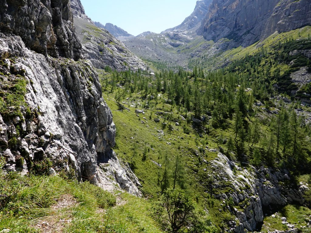
After lunch the rain continued as I started a 1500m descent down the Giralba Valley. On top of the 500m descent of the morning it was hard on the knees as I was cautious on the greasy damp rocks. It took a good half hour down the stone and grass slopes before I reached the first of the dwarf pines at the tree line around 2000 metres. The mists on the higher slopes were clearing and some of the great spires on the ridges of the high mountains were appearing. The journey down into the larch and then spruce was welcoming as not only had the rain stopped by there were flashes of blue sky.
Down and down the route went zig-zagging on the comfortable path beneath the conifers on the steep slope. The forest understory was now green with small berry bushes, mostly blueberry and cranberry, but also many heaths. A good two hours after leaving Refugio Carducci at about 1300m altitude I quickly entered the deciduous forest, mostly of beech. The green canopy contrasted brightly with the reddish brown forest floor of leaves. Cyclamen with their purple propellor shaped flowers were bursting through the dead leaves.

09. On the long descent from Rifugio Carducci down the steep valley of Val Giralba the conifers give way to the beech woods at around 1300 meters
At Pian de la Salere two valleys met in a mass of white stone debris like two glaciers meeting. Here there was a bridge over the main stream to the east side before the last final 500m descent through mixed forest to finally reach the floor of the Val D’Anseil at the small hamlet of Giralba. Although it was dry now I had decided to call it a day hoping there would be an Albergo in the hamlet. There was none but just a 20 minute walk down the road brought me to the village of Ligonto. Here there was a great simple hotel called Albergo Cacciatori. It was perfect. I went in and got a room and hung all my wet and damp gear on the balcony before having a shower and washing my clothes. The Albergo also had a great restaurant for my evening meal, mostly of local cheeses.

10. The Albergo Cacciatori at Ligonto in the main valley of Val D’Ansiei is near the Ponte da Rin bridge and is well placed and good value for money
Alta Via 5. Day Three. Ligonto to Rifugio Chiggiato. 18km. 7 hours. 1610m up. 530m down. After a magnificent stay at the Albergo Cacciatori I found that I was just a few hundred metres from the Pont da Rin bridge. There were lots of variations to the AV5 here to avoid the 3 km of road walk up the Val da Rin valley, some even involving a chairlift. However they all seemed pointless and the original route up the quiet road would be over in a hour anyway so I chose to take it. I noticed there was another hotel in Ligonta right opposite the bridge. Once I crossed the bridge of the Ansiel River I started up the road between tall spruce. It took less than an hour to reach the quaint and surprisingly small Primula restaurant. During the entire 3 km only about 10 cars passed me and all were going slowly on this small dark road winding along the valley floor beneath large spruce. After the Primula the tarmac road ended in a gravel track which forded the river. It was tricky to find a place to cross without getting wet feet. A few hundred meters further on beside two small summer farms in grassy meadows the trail left the track and started to climb.

12. The climb up out of the Val da Rin valley towards the Rifugio Ciareido was initially easy through the beech woods but became steeper towards the rocky top
The climb was quite relentless for 1000 steep metres. I put myself into 4 Wheel Drive Low Ratio and slowly ground up the ever changing hillside. Initially the trail was wet and went through spruce forest but then it climbed into my favourite beeches, where cyclamen covered the ground. After a good hours climb it crossed the deep and rock covered streambed and then continued up gravel for another good hour. The vegetation changed from beech to fir, and then larch, and finally dwarf pine, as the path veered to the east and climbed more steeply between crags. There were occasional wire cables, but they were more as an aid to scrabbling up than safety. After a good half hour of this the route finally reached the top at about 2000 metres. After looking at the map I could see that was the climbing done for the day. There was a tremendous view from here eastwards over a high wooded plateau dotted with alps and malga, or dairies, and north to the area I had just left. The Popera and Toni massifs were clear and I could even make out the route of yesterday’s via ferrata. While everything to the southwest was the Marmarole massif where I would spend the next 3 days.

13. Looking back north from the top to the climb up from Val da Rin towards the Toni and Popera massif I was in for the last two days. Bivacco Toni is hidden in the saddle tp the left of the highest peak which is Croda die Toni
I stared down the narrow path between the stout dwarf pines which would occasionally try and overbalance me if I pushed into them. There was one tricky area of loose rock where there had been a recent landslide and it was still a weeping wound in the landscape. After delicately skipping round it I just had an easy 15 minute jaunt through the sturdy pines to reach the Rifugio Ciareido sited on a knoll. It commanded a superb view over the dairies and pastures of this high plateau to the east and on to the really impressive towers, spires and peaks of the large Spalti di Toro massif of the Dolomites on the other side of the vast Cadore Valley. I went into the cosy refuge for my lunch of 4 small cheese and tomato rolls washed down with sparkling water. It would have been a nice refuge to spend the night at but I still had 3 hours to walk to Rifugio Baion and the Rifugio Chiggiato. This walk would contour around the south side of the east end of the enormous Marmarole Massif.
For the next 3 hours the path, which was often small, gave me some of the best hiking in the Dolomites to date. It was relatively easy for the first hour to Rifugio Baion through larch and fir woods with patches of meadow here and there. The meadows were still full of flowers and long grasses, and even in the woods there were plenty of flowers. Cranberries were forming, crimson red, on the small prostate bushes. The path dropped a 100 metres or so to reach Baion, which was previously a dairy. The dairy buildings were still intact and well kept and formed a triangular enclosure with stable doors leading onto the enclosed courtyard. The refuge itself was the old barn or hayloft and still had the ramp for the horse drawn cart to pull the cut grass up. In the pasture around Baion the heavy rhythmic clunk of cow bells rang out as some 30 cows grazed the pastures. It was an idyllic scene from a bygone era now too rarely seen.
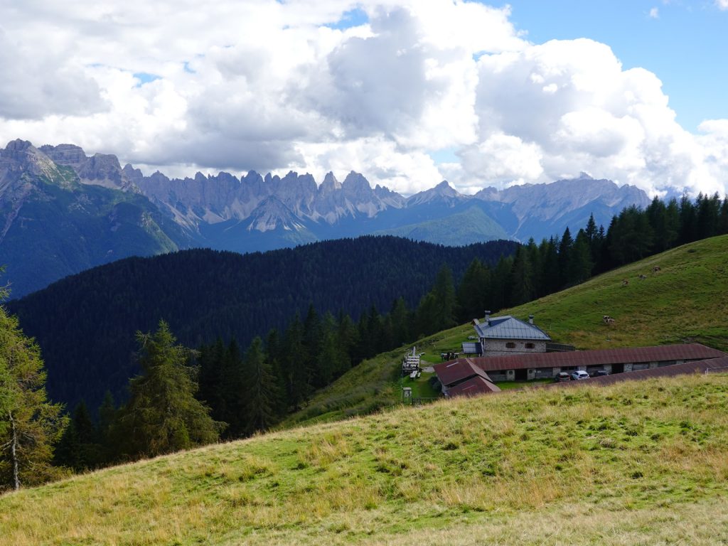
14. Rifugio Baion is an old Malga, or alpine dairy, where the hayloft has been converted to simple mountain lodging. The enclosed buildings still serve as a stable for cows. In the distance is the Spalti di Toro massif.
After Rifugio Baion, which looked the nicest refuge I had seen and I was sorry not to be staying, the path continued to contour round the hillside just at the top of the treeline for another 2 hours as it circled round a large forested natural bowl to the southeast. While on the northwest side the jagged ridge of the Marmarole massif started to get more and more impressive. After half an hour there was a path to the north up and over this ridge to the small red Bivacco Fenton just on the other side of the ridge. It was another official variation of the AV5, but it seemed a bit pointless. The path continued to contour round for the next hour. Occasionally there were short stretches of wire cables over outcrops but these were largely superfluous but comforting to hold onto. At last the trail reached Forcella Sacu, a pass clad in large firs. There was a T junction here with a branch going up and over the Marmarole to Bivacco Tizian, Bivacco Musatti and Bivacco Voltolina, all on the north side of the Marmarole. I would take this difficult, wild and remote path tomorrow and stay in at least one of the Bivacco, if not two. There was plenty of via ferrata section along this branch of the path and good weather for 2 or 3 days was imperative.
But now I would take the other trail for 10 minutes to the Rifugio Chiggiato. It was a superb easy walk along the side of a side ridge comprising a few grassy knolls to reach the quaint refuge. There would only be 5-6 of us staying and I got my own small room with a great view. It was also an old dairy building which had been converted long ago into a refuge. it was rustic but full of charm with tremendous views. Perhaps the most impressive view was southwest across the valley to the massive steep lump of Antelao, the King of the Dolomites, and the second highest mountain in the range after Marmolada, the queen of the Dolomites. I was still carrying 3 days of food with me so I decided to eat one of the days to reduce a kg of weight and give myself more room in the rucksack for the next few demanding days until I reached the cosy San Marco hut. If I was unfortunate enough to arrive in this area as bad weather hit I could skip the big loop over the Marmarole and round it’s west end and go straight to Rifugio Galassi via the valley, but that would not be in the spirit of an Alta Via 5. I wrote early and then enjoyed the clearing evening sitting outside as the sun set and cast an alpenglow over these unique mountains.

15. Rifugio Chiggiato is a converted summer dairy farm which has a great location on a alpine knoll overlooking the Oten Valley. In the background is a side ridge of the Marmorole massif.
Alta Via 5. Day Four. Rifugio Chiggiato to Bivacco Musatti. 11km. 8.5 hours. 1240m up. 1060m down. From the superbly appointed Rifugio Chiggiato on its alpine knoll in the midst of dramatic scenery it was an easy saunter back to the main Alta Via 5 trail again where I was last night and the path forked into 2 branches. I took the rugged fork to the northwest which now contoured the mountainside on a small path which was quite rough with plenty of small ups and downs. A couple of these were reasonably difficult and one gully in particular had, and needed, cables up it. Below me to the south was the large Val D’Oten full of eroded white stones which filled the valley floor. It rose up to the Rifugio Galassi where I would be in a couple of days. Although the Marmarole on which I was hiking was impressive with its spires just the other side of the valley rose Antelao, its huge pyramid shape dominating the skyline.

16. The view from near Rifugio Chiggiato across the Val d’Oten valley towards Monte Antelao, the second highest mountain in the Dolomites.
After a couple of hours of this small path it headed into a side valley and reached a buttress which was the start of the via ferrata section. The via ferrata itself was not that difficult as the angle of the buttress was less than 45 degrees. At the steeper bits there were old ladders, many contorted by previous rockfall, to make the ascent easy. The exposure was never that great and it was a comfortable climb to take a beginner on. The entire ascent lasted for about an hour and a half. There were many flowers, some still in bloom to give added interest to the climb. Eventually I mounted a crest and could see the pass just a few hundred metres away. This last part was the most difficult and the most exposed and there was a lack of cables where I thought they would be useful.

17. At the top of the scramble up to the pass of Forcella Giau de la Tana. The last bit from here to the pass was the most exposed and lacked wire cables.
At the Pass of Forcella Giau de la Tana, at about 2650m, the climb ended and a wonderful view burst open to the north with jagged massif after jagged massif all the way to the Austrian Alps. Perhaps the most impressive mountains are the neighbours of Cadini di Misurina, the Tre Cimes and the Toni/Popera Massif, where I was just 2 days ago. To the east just above me was Cimon del Froppa, the highest peak in the enormous Marmarole Massif. I had a lunch of snacks here overlooking the high valley into which I was just about to descend and admiring the peaks beyond many of which I had trekked around on previous Alta Via routes I had done before.

18. Looking back down the I just scrambled up to get to the pass Forcella Giau de la Tana. The valley far below id Val dOten with the Spalti di Toro massif in the background
The descent was easy into a high valley which still held a few large snow fields on the north facing slopes. The loose small scree fields made for long quick footsteps without much thought until I reached the boulders at the bottom. There was now much more need for caution. It seemed all the snow melt just disappeared into the ground and there was no water available so I was looking forward to getting to the Bivacco Tiziano, where surely there would be water. The day was warming up considerably and I was parched. About half an hour before the Bivacco I came across a herd of some 15 Ibex. The magnificent horns on the bucks looked formidable. If one had charged me it would have knocked me for a six. The final km before the small red hut went across a karst type landscape with deep slots and jagged surface. Plants in some of the slots probably never saw the sun. At the well appointed Bivacco Tiziano there was a great view down the valley but I would have swapped this for water of which there was none. There was a vague reference in the hut book to a dripping cave a km to the south but that was it. After an exploration of the hut and the restored, but locked, historic stone refuge beside it I decided to head off to Musatti and hopefully find this dripping cave.

19. An Alpine Ibex, Capra ibex, on the karst type terrain near the Bivacco Tiziano hut. The larger males can reach a metre high at the shoulders and weight 100kg and they are extremely sure footed and nimble
I looked at all the potential dripping caves on the northside of Pic Monticello which surrounded a large grassy meadow full of marmot. One kept guard shrieking loudly to warn the others to take cover in their burrows. I wasted a good hour looking at all the wet patches on the rocks and expended considerable effort but all to no avail, so I eventually decided to cut my losses and head off to Bivacco Musatti where I knew there was water half an hour down from the shelter. It was a long 500 meter climb from Tiziano hut up to the large side spur off the main Marmarole ridge. This side spur was topped by Tacco del Todesco, 2644m, and the climb went nearly to the top. The grassy slopes were steep and rocky but full of flowers and alpines, which eased the dry slog.
21. The unuque karst type landscape in the area around Bivacco Tizian and the high valley of Val Longa. The route after the Bivacco Tizian shelter goes up the ridge on the right to the centre peaks.
The descent looked to be difficult but as so often in the Dolomites there was always a hidden option that was easy. This one dropped down into the massive scree filled bowl which had a few snow fields. The scree was small and the gradient was gentle so it was easy to run down. Soon the red Bivacco Musatti hut appeared on the grassy slopes at the lip of the bowl. I was hoping for water but just by looking at the karst geology knew it would have all disappeared into the ground.

23. The view from the Bivacco Musetti shelter north across the arterial valley of Val D’Ansiei. The left and centre left mountains are the Cadini di Misurina, the centre right are the Tre Cimes de Lavaredo and far right Monte Paterno
There were already two Italian climbers at the hut. They had come to climb Campanile San Marco, a formidable 15 pitch tower just to the south of the hut. They were very welcoming and made space for me but I decided to sleep outside on the ground as it was a wonderful evening and the weather was fine. There was no water here and the Italians were also short so I volunteered to go down 250 metres where there was reputed to be a spring gushing cold mineral water. It took me just 15 minutes to reach it with an empty rucksack and it was worth it. It was the best water I have tasted for a long time at the spring at 1820 metres. I quickly climbed back to the hut with my bounty and we had a great evening. One of the Italians was a trauma doctor at Verona Hospital so the issue of coronavirus came up but we quickly moved on. I eventually got to bed at 2130 after quite a long day but was pleased to be sleeping outside.
Alta Via 5. Day Five. Bivacco Musatti to Rifugio San Marco. 12km. 10.5 hours. 1040m up. 1230m down It was a superb night under the stars and I could easily make out the Big Bear and Cassiopia, both of which helped me find the north star around which every other star revolved, anticlockwise I noticed. I soon fell asleep but woke with a mouse trying to gnaw through my cuben fibre food bag. By now the moon had risen and it was bright enough to read and all but the most tenacious stars had vanished. I was surprised how little dew there was in the morning when I woke. The climbers, Michael and Ekarem , were already up. We breakfasted together in the hut, then they prepared all their climbing gear for the ascent of Campanile San Marco. The used two ropes both 50m long and 8.5 girth as it would help with the multiple pitch abseils they had to do. We all set off about 0800, me with 3 litres of water after yesterday’s parched lesson.

24. The climb up to the pass of Forcella de Mescol from Bivacco Musatti is up across steep grass.
The path headed south into the valley for a bit passing through meadows of flowers, especially sow thistles and a pale yellow wolfsbane around which the bees were buzzing. I could see the climbers at the foot to the vast tower they were going to climb. My faint path went up to the east, initially on steep grassy slopes to the foot of some cliffs. It then hugged the base of cliffs and climbed steeper. In the wet this would have been quite dangerous as it was slippery and about 40 degrees. It then got to the base of a gully in the cliff, but I was more reassured as there was a cable to secure to. At the top of the gully there were more unsecured steep grass slopes which soon led to the narrow pass called Forcella del Mesco, about 2400m and up 300 from the Bivacco Musatti. I could now see the route ahead and realized that this steep ridge I had scrambled up was just the warm up and the next ridge was much more foreboding.

25. Looking back down to the small red shelter of Bivacco Musatti (photo centre) from the climb up to Forcella de Mescol which is just behind me.
The descent to the west was down steep grassy slopes which again would have been dangerous in the wet. The faint path then veered to the right and descended down a crag on fixed ropes to reach the screes of the vast basin called Meduce de Inze. I was comfortable on the screes as it was a concave slope and if I slipped there would be no consequence. At the bottom of the screes in the basin were some huge boulders and a mass of hardy alpines with many saxifrage varieties. I noticed there were also some small larch trees trying their luck at this altitude of about 2150m. Although I had just been going for 2 hours I paused as I wanted to get rid of some weight and drink water.

26. The series of 6 broken and twisted ladders up the gully en route to the exposed saddle of Forcella Croda Rotta. Note the large stones wedged between the ladders and the rockface.
The climb up to the next ridge was much bigger. After a bit of scree it was largely up a grassy slope peppered with small outcrops. This led to a gully, almost a chimney which had a series of twisted ladders up it, perhaps 6 altogether and a cable for security beside them. In a storm I should imagine this gully is a torrent with water cascading down and sweeping stones with it to further bash the ladders. At the top of the ladders the gradient eased as I followed the scree at the base of the cliffs and then easily ascended up shallow broken rock and boulders. Rather surprisingly the route now veered to the right rather than straight ahead and slowly ascended gently sloping slabs with no hint of exposure despite the slabs being on top on the crags below. I was pleasantly surprised how easy it was to walk up these to the very airy pass called Forcella di Croda Rotta at 2569m. Below me to the west a long long way down was Val Del Fuogo. The trouble was there looked no easy way down through the jumble of crags, spires, side valleys and vast cliffs. In fact I could not see the path until I noticed it climbed still further across steep exposed slabs with no cable protection for 50 metres to a crest and then once I got there another 50 metres unfolded which took me to the top of a long gully full of scree. I was very surprised none of this was protected as one slip and it was a long way down. I very cautiously made my way along these slabs to the top of the scree filled gully.

27. The view west from the top of the exposed saddle of Forcella Crodo Rotta. In the distance is the high mountain of Sorapiss. In the centre is the huge buttress of Corno del Doge with the via ferrata route traversing the ledge in the shade.
The scree filled gully itself was far from safety until I was a good 200 metres down it when it spilled out onto a fan of scree. I could now breath easy again as I stomped down the scree without a thought to where I was placing my feet. I descended diagonally on a used path across this field of scree until it reached the bottom of a spire. I thought, and hoped, I would continue down but that was not the case. Instead I had to climb up the scree on the other side of the tower for a good 100 metres. Obviously the path builders of old knew there was no way down the obvious way and hence the need for the detour further south. At the top of this scree I got a great view to the south down Val Vanedel which eventually flowed into the vast Val D’Oten. I was on the crest of the main Marmorole ridge! From here it was a long cautious descent on steep gravel and then a short section of vertical crags with cables to reach the Pass of Forcella Vanedel. Here I could peer down the vertigo inducing gully on the south side as it plummeted 4-500 metres. This essentially marked the end of the second ridge or section of the day but I still had two more to go!

29. The descent down the Cresta Vanedel weaves it way down this face to reach the crags at the bottom. Here wire cables aid the way to the slot like pass of Forcello Vanedel
The third section was around the huge buttress on the north ridge of Croda De Marchi between Val Del Fuogo and Val di Mezzo. There was a short climb from the pass up ladders and cables to terraces of rock on the bare mountain. I had expected to follow a terrace contouring round into Val di Mezzo so was surprised when the route descended from terrace to terrace as it went round the buttress. Occasionally there were cables between the terraces but the terrain was not that steep and the rock was very abrasive and sticky on my boots. It took nearly 2 hours to go round this buttress, descending a couple of hundred metres in the process to reach the spur on the buttress enclosing a high hanging valley with a green meadow and scattered larch trees. It was a lost Shangri La on this day of brutal rock and scree. As the path reached the end of this descending traverse of the buttress there was a short exposed via ferrata section which was sensational. As I shimmied round I could look across a couple of meters of air to the tops of the 30 metre larches growing on the valley floor. I had to walk up this valley, Val di Mezzo for a good km to reach a junction of paths. It was a very green pastoral valley, too wild and remote for domestic animals but perfect for Chamois, Ibex and Marmot. It’s lush welcoming greenery was further enhanced by wispy larches. High up the valley I could see the red barrel shaped Bivacco Voltolina where I could have stayed in the 9 bunk shed.
31. The short via feratta section across the cliffs here leads one into the pastoral Val de Mezzo in which the Bivacco Voltolina shelter is found at the treeline ahead.

30. The huge buttress of Corno del Doge is nearly 1000 metres high. The Via Feratta Cengia del Doge cuts across it on the obvious ledge from the left to centre right of the photo.
However I wanted to continue round the infamous Cengia del Doge path which I had first seen 5 years ago when I did the Alta Via 4. It was the fourth and final section of the day.. The very airy path followed a natural ledge around the north face of Corno del Doge, which I guessed was about 600 metres of sheer rock with this ledge across the middle of it. As I set off on the small path through the larches towards the looming tower the path became more and more squeezed between the rock face above and the cliffs below. After some 20 minutes from the dry stream bed and junction of paths in Val di Mezzo the path started its exposed traverse. The ledge was perhaps 5 metres wide and often covered in stout dwarf pine which protected me from the exposed north side. Occasionally the dwarf pine vanished and then the full horror of the path was laid bare. In a few areas where there was some sloping scree there were some cables. I did not look down into the abyss far below but kept plodding on doggedly. There was one small buttress within this giant buttress and this marked the corner where the path veered south to finish the traverse high above the Val de San Vido valley. The traverse of this small buttress was protected by cables. As the route now veered south there were a few more cabled areas before the cliffs below the ledge vanished to be replaced with crags and scree and then long slopes of scree all the way to the wooded valley floor. The path traversed these easy screes and soon I was on the valley floor in the larches.

33. The sensational ledge across the huge buttress of Corno del Doge. The ledge is nearly a kilometre long and 2-5 metres wide with a nearly vertical 400 metre drop on the north side.
I stopped here to take the harness and carabiners off and finish my water. I knew the way from here and it was quite easy. I had finished all the demanding bits of this long day. Just 20 metres after my stop to finish my warm water I came across a large spring gushing cold clear water. It was unfortunate as I could not stop again. Indeed the path crossed a few more springs before it met a larger path coming up from Palus San Marco to the north. I followed it up the thinning larch forest between the massifs of Marmarole to the east and Sorapiss to the west. Ahead of me was the last most westerly bastion of the Marmarole massif which was the singular tower of Sabbioni, standing proud and alone like a giant chess piece. It was a climbers mecca. Before long I reached the pass of Forcella Grande between the two massifs of Marmarole and Sorapiss, It was a pleasant pasture of undulating meadows and small rocky outcrops. From the pass at 2255m it was a steep 400m descent on a good path to the lovely Rifugio San Marco. It was quite busy as it was Saturday but they found me a bed. Then to my joy they said they remembered me from a few years ago when I passed through here on the Alta Via 3. The host remembered taking a photo of me and the British alpine guide Tania Noakes who had done the Norge Pa Langs ski trip using my book. I had a nice 3 course meal and wrote the blog with my forehead feeling it had caught the sun. I was lucky with the weather for the last 2 days. I don’t think they would be easy in anything other than the perfect weather I had.

34. After the exposed ledge has rounded the Corno del Doge buttress the route descends across screes into the forested Val de San Vido valley where the difficulties for the day are over.
Alta Via 5. Day Six. Rifugio San Marco to Rifugio Antelao. 13km. 6.5 hours. 1130m up. 1170m down. I slept well at the delightful, friendly rifugio and headed off about 0830. There was a bit of urgency today as forecast said the weather was going to break in the afternoon with heavy rain showers. I wanted to be up and over the Via Ferrata Ghiacciaio before the rain came, especially if it was accompanied by thunder and lightning. So after my goodbyes I stormed off up the track towards Forcella Picola and the Rifugio Galassi. It was an easy path contouring round a large south facing bowl. On each side of the path dwarf pine thrived. just towards the end it climbed slightly and dropped a little towards the Refugio Galassi. To my right was the enormous and foreboding bulk of Antelao. It was already shrouded in mist but I could see the via ferrata was still clear.
I did not stop at Refugio Galassi as I had just been going for an hour. I chatted briefly with a young german couple and 3 Italians who were also at Refugio San Marco and also wanted to do the same via ferrata to Rifugio Antelao. The Italians did not have my sense of urgency and went in for a coffee. I powered up the hill behind the rifugio climbing the 400m in under an hour to reach the bottom of the 200m high slab where the cables were. At the top of the rocky screes were a small herd of ibex grazing beside the path. The mountain of Antelao was lost in the mists swirling above me but I could see the ridges leading up to it as they emerged from the mantle of glaciers surrounding the peak. It was very atmospheric but I could see no sign of rain and knew in a hour I would be over the worst of it.

35. The Via Feratta Forcella del Ghiacciaio goes up the middle of the rock face above climbing some 300 metres to the crest. It looks challenging from this forshortened view but it is only 45 degrees
I put on my harness and helmet, clipped into the cables and started to climb. My boots were quite pliable and the soles gripped the 45 degree slab perfectly and this gave me confidence just to haul myself up the cables. At every anchor point I had to unclip one carabine and move it past before repeating it with the second carabine. The anchor points were about 5 metres apart so this slowed me down a bit. I made good progress and it only took me about an hour to climb the entire slab. Just as I neared the top I could see the 3 Italians and 2 Germans arrive at the base of the climb. Then for some reason the 3 Italians turned back. The cables ended on the sharp crest. between two glaciers, and this is the pass Forcella del Ghiacciaio This crest must have been covered in ice 50 years ago but now it was laid bare as the glaciers retreated. I went east along this crest for a good 100 metres towards the mountain where there was a way down off the south side onto the moraine at the end of the glacier. I could see Ibex far below me on the south side also as the foraged among the moraine for plants.
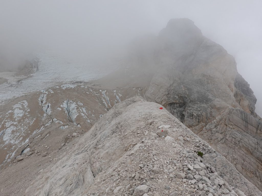
36. At the top of the Via Ferrata Forcella del Ghiacciaio there is a small crest to follow westwards towards the glaciers and cliffs on the looming bulk of Monte Antelao for 200 metres.
Turning east I now had a long descent down the moraine debris, much of it still recently deposited and unstable. I continued cautiously for half a km past the Ibex to reach a short sharp descent. Since I was last here 5 years ago the route down slabs I descended previously has been abandoned and a new shiny section of cables had been installed on the left side (looking down) of the step. I went down the cables gripping them tightly with my gloved hands and not putting my harness on for the 50 metre 45 degree drop. This deposited me at the top of a vast scree filled valley which was safe but slippery to walk down. Rain torrents had carved hard channels in the stony debris which had loose gravel on top. I was thankful for my walking poles which I could jab into the surface to increase my grip. This unpleasant terrain lasted for about half an hour and only ended when the path veered to the left off the moraine and onto the grassy meadows at the side.
The grassy meadows were a delight as they were full of the purple alpine gentians. It was also a mental relief as I knew now if the heavens opened with the forecast rain I was out of the difficult and dangerous terrain. As I descended the dwarf pine soon appeared and then the larch trees started to pepper the meadows and shrub pines. When I reached the bottom of the slope on the valley floor by a path junction a cool clear spring erupted out of the ground. There were flat rocks to sit on and a fleeting patch of sun so I had a stop here. It was a beautiful spot at the head of a Shangri La of green pastures across the valley floor called Pain de L’Antelao. I could hear the clunking of cow bells from the larch woods where the livestock must have been grazing.

37. After the meadows of Ciampestrin the path climbs to the pastoral saddle of Forcella Piria and then contours to the south of Crode de San Piero seen here.
There was just one final climb from this pastoral idyll up through the larch woods to another meadow called Ciampestrin. On the way up I felt a few raindrops and began to prepare for the deluge, but it never came. Still with some urgency I continued to climb up the side of the valley above the meadow through thinning larches to Forcella Piria, 2100m. I had expected to see rain sweeping up from the south as I crested the path as certainly the skies looked very dark, but instead I had the reassuring sight of just a heavily overcast day with only the tops of the immediate mountains in the clouds. Just 2 km away to the east I could see the saddle where the charming Rifugio Antelao lay at a height of about 1800m. It was in a grassy alp surrounded by firs. I was sure I would get there in about half an hour and dry. The path was a grassy strip between the dwarf pine which covered the hillside on the south side of the hill, Crode de San Pietro. It contoured around this hill climbing every so slightly before it got to a saddle on the east side of it and then started the final descent on a soft path through the fir forest to reach the Rifugio Antelao. It was as charming as I remembered it from 5 years ago when I did the Alta Via 4, which also comes this way.

38. Harebells, Campanula rotundifolia, beside the path in the woods between Crode de San Piero and Rifugio Antelao. Even in September they are spectacular.
It was only 1430 and I could have descended down to the end of the trek at Pieve de Cadore, some 2-3 hours away. However a night at this simple lodge to enjoy the beauty of the Dolomites was not to be squandered for a comfortable hotel in the suburban fleshpot of Pieve de Cadore. Furthermore the promised rain seemed imminent now and I would be soaked. I got a warm welcome and shown a 12 bed bunk room which I would probably have to myself. I knew the young German couple would show up later and they were just finishing the Alta Via 4 so we could dine together and have a few celebratory beers before tomorrow’s descent into Urban bustle. As I wrote the blog I noticed it was pouring outside. I sat near the huge stove sipping my radler feeling quite smug. The Germans turned up about 1600 dripping wet but with a glint of victory in their eyes having done the last stage of the Alta Via 4 which they had nearly completed. They also stayed the night. That evening the cook made a huge meal for us. I was given a hearty bean soup, fried cheese and polenta for the main, and a large dish of pannacotta for dessert. Rifugio Antelao had come up trumps again with the evening meal. I was in a room with 12 beds but being quite late in the season and with the poor weather forecast and the covid 19 restrictions I had the room to myself.

39. Rifugio Antelao is a delightful place even in the drizzle. From here it is just 2.5 hours to the end of the AV5 walk at Pieve di Cadore
Alta Via 5. Day 6. Rifugio Antelao to Pieve di Cadore. 8 km. 2.5 hours. 20m up. 970m down. I knew it was an easy day down to Pieve di Cadore so I started leisurely at 0830. It had rained hard in the night and everything was wet with pools of water lying on the ground and even a film of it across the outside tables. The morning drizzle was still splashing ripples across the wet surfaces. The young Germans had already left half an hour before I set off. Mists came and went as I sauntered down the autumnal track for a kilometer passing rowan trees heavy with red berries and whose leaves were just starting to turn. I knew from previous times there were great views from the ridge here north towards the Marmorole massif but there were none to be enjoyed today. After some 20 minutes I reached a small alp with a couple of log cabins at the gentle pass of Forcella Antracisa. Here I left the official Alta Via 5, which went down the hairpins of the track, and found a small path, numbered 253, which went down to Pozzale. I had taken it before and it was more rustic and also shorter.
The path dropped down to the south east through the conifers descending gently as it traversed the slope. After a km it got to a bowl of scree but continued to descend across it to reach a wooded ridge. The path followed the gentle arboreal ridge down with the forest floor covered in mushrooms and cyclamen. However after a further km the forest was devastated by near enough clear felling which continued all the way down to beyond the alpine huts and meadows around Costede. The path I remembered from 5 years ago was now strewn with smashed branches and broken trees. There was a route of sorts through it where the 6 wheel drive extractor tractors had forced themselves, crushing everything in their way, which was tolerable to follow. But the idyllic forest was gone. When it did reappear there was a hardcore lorry road through it where timber lorries removed the logs for industry. Towards the bottom of the debris I caught up with the two Germans who were appalled at the clear-felling, “It would never happen in Germany” they said but it does happen there too.
Just before we reached the hillside hamlet of Pozzale we saw a striking Salamander cross the gravel track. I saw a similar one in Corsica once, also in the rain. This one was a fire salamander and it looked very vulnerable. However fire salamanders secrete a toxin called Samandarin, which is very toxic, and even potentially fatal to humans, so they are left alone in the wild and can live for many decades.

40. The Fire Salamander, Salamandra salamandra, can live for a few decades and protects itself from predation by secreting toxins. I spotted this one just above Pozzale in conifer woods.
As we entered Pozzale the track became tarmac and we followed it through the village which looked very quiet and traditional. The road now dropped down for some 2 km to reach Pieve di Cadore, which was the end of the Alta Via 5 for me and the Alta Via 4 for the young Germans. We did not follow the road but found a small track just to the north of it where the locals walked. It took us down into the centre of Pieve di Cadore near the typically Italian main square with its church, council offices and town hall. There was a market in the square but it looked subdued due to the drizzle. The Germans stopped here to have a coffee but I continued on for another good km to the next town which was Tai di Cadore. It was on the main road from Cortina to Venice and it was necessary to walk down to it to get the bus. It duly arrived around 1100 and took a couple of hours to get to Venice Mestre.
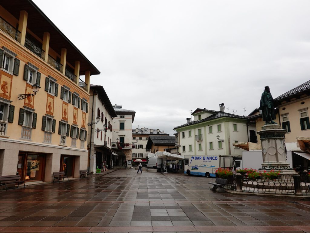
41. The market aquare in the center of the small town of Pieve di Cadore is the end of the AV4 and the AV5. From here is is necessary to continue a km to Tai di Cadore to get a bus.
Whenever I do one of the Alta Via walks I always leave a couple of days spare in case of bad weather which could delay the walk, especially if there is thunder and lightning forecast on the via ferrata sections. I seldom use up these days so it usually means I have a couple of days to spare at the end exploring Venice. It is my fifth visit to the city now and I am getting to know it quite well. I took a water bus straight to the quieter, more discerning island just to the north of Venice and once there booked a room for 2 nights as a base camp.

42. Once of the canals in through the island of Murano just to the north of the island of Venice

43. One of the canals in the colourful island of Burano half an hours boat bus journey from the Island of Venice
Over the next few days I visited all the islands which surrounded Venice; like Murano, Burano, Torcello and Giudecca. I walked about them all for half a day or so and spent the other half in the cut and thrust of Venice before fleeing back to my refuge in Murano. On the last day when I was tired of pounding the streets I went to the seldom visited Island of Sant Erasmus, the vegetable garden of Venice, and hired a bike from the hotel there. Sant Erasmus turned out to be one of the highlights of my metropolitan foray. It took a water bus to the airport on the evening of the last day for a very late flight home to bring the magical trip to a close. Is there anywhere better to be in early September that doing a Alta Via in the Dolomites followed by a few days exploring Venice? There are 10 Alta Via’s all together and luckily I still have five left to do. Five more early Septembers to look forward to.

47. The Rialto Bridge is the oldest and most important of the 4 bridges spanning the Grand Canal in the heart of Venice. It is nearly 450 years old now and replaced an earlier bridge.
Alta Via 5. Alta via di Tiziano. Sesto to Pieve di Cadore. 88 km. 7 days (48 hours).. 6420m up 7200m down