Section 16. Sisters to Hood River
Section 16. Sisters to Hood River. 2-9 September. Sisters was full of charm and it was nice to see deer and their well grown fawns wandering the streets and grazing on the irrigated lawns and parkland. I would have liked to linger and enjoy its Bohemian tourist vibe, but Canada was calling and I had to go north. I also had unique permission to through a small part of the Warm Springs Indian Reservation on certain conditions. One of which was I only camped in a certain place, so I had to make sure I was at the southern boundary tomorrow night to achieve this.

01. Deer and fawns in the streets of Sisters eating the urban vegetation.
There is a network of trails around Sisters, and I was going to use two of them to head north. One today and one tomorrow. So after my final meal I headed off to the ranger station to pick up the Sisters Tie Trail, a 6 mile trail which delivered me to the Indian Ford Campground on the south side of Black Butte.
The well marked trail was pretty much flat the whole way as it followed a series of paths and very infrequently used and faint dirt roads. The trees along the trail were nearly all second growth ponderosa pines some 60-70 foot high with a undergrowth of patchy bitterbush growing in the sandy soil. It was very easy underfoot and gentle walking. it got dark before I reached the campground but when I did it was easy to find what was becoming my favoured campsite, a US Forest Service picnic table, on which I cowboy camped.
From the campsite it was easy to find the adjacent Metolius-Windigo Horse Trail, which was an extensive trail in Oregon. I followed this trail through ponderosa forest on the east side of the conical Black Butte mountain for about 6 miles. It crossed a few other trails but I looked for the yellow diamonds which seemed to mark the trail. When it reached the north side of Black Butte it descended gently to a parking area near the headwaters of Metolius River which I detoured to see.
Underground water channels took water from far away and brought it to here on the north side of Black Butte, where it emerged as a vast spring, which was the source of the Metolius River. More springs feed into it within the first mile and soon it was a river 10 yards wide and a foot deep. I followed it down and noticed how lush the banks were. There were many old bohemian cabins on each side of the river, and 2 miles from the source was the lovely village of Camp Sherman.

02. The cabins beside the upper Metolius River were a century old and many were heirlooms
Camp Sherman was obviously a tourist destination but it had huge charm. The cabins surrounding it were either old and traditional, or made to look so. There was a great store which was also a deli, fishing tackle shop, clothes store and meeting place. Next to it was a very traditional post office with old PO boxes lining the wall. The whole place had a very relaxed vibe. I took advantage of the deli and had a couple of bean burgers while the owners charged my phone battery.
From the relaxed, riparian, fly-fishing culture of Camp Sherman I continued down the Metolius River for another 8 miles. There were many fishermen fly fishing here, and it was the only type of fishing allowed. There was hatchery half way down which ensured the river was well stocked with about 4 different types of trout. There was a path down each side of the river with huge ponderosa and Douglas Firs beside it. Near the path was a gravel road which allowed access to a few Forest Service campgrounds along its banks, which were quite busy. However there were also long stretches of wild river with ospreys nesting in the ponderosa pines. I was surprised how quickly the river grew and just 10 miles from it source it was 30 yards wide and 4 foot deep, with small rapids.
It was as good a walk down the river as I have had in Oregon, or indeed North California, and it was quite refreshing to know that the PCT was not the only beautiful path. Indeed it was exciting to go off piste and wander at will and come across such gems.
At the Lower Bridge Campground I left the beautiful Metolius River and headed west on a series of dirt roads for a few miles crossing Abbot and Candle Creek until I reached Jefferson Creek. It was the southern boundary of the Warm Springs Indian Reservation and I did not have a permit to enter it until tomorrow so I camped just before it.
One must have permission to enter the Reservation. It is almost the same legal entity as a separate country with its own laws and regulations. US federal authorities do not have jurisdiction here. Entering without permission is trespassing and subject to the reservation administration laws. I was lucky to have obtained permission for 3 days but it was subject to certain conditions, two of which were I could only camp in one particular campsite at Trout Lake 30 miles to the north, and I had to stay on established roads and trails to get there. So I planned a very early start.
The alarm went at 03 and I walked across the bridge over Jefferson Creek, through the gate and onto the Indian Reservation at 0345. The moon was full but it was blocked by smoke. I trudged up the track for a good 2 hours until the first hint of daybreak appeared. The only incident of note was having a skunk run at me, tail up and eyes gleaming in the headtorch. I backed off a good 10 foot but it kept coming. Just as I thought I was going to get sprayed it turned and fled.
I think the SW portion of Whitewater is primarily used for timber. It was a mixed forest with Ponderosa and Douglas Firs being the larger trees. The harvesting timetable and the process of felling seemed to be well managed. On each side of the main arterial road I was on were many different smaller access roads, all well numbered and maintained. The harvested areas were scattered about with, 100 acres or so done at any time. So the forest was varied with some areas just harvested and others with 100 year old trees ripe for harvest. In the harvested areas there were plenty of seeding trees left with a mix of species, including Larch, Western White Pine, Sugar Pine, A true Fir and mostly Ponderosa and Douglas Firs reflecting their natural mix.
By 10am I had already done 16 miles and reached the White Water Creek. It was cloudy with glacial silt from Mount Jefferson to the west. At the creek a pickup stopped and questioned me. He was a forestry worked from Oregon contracted to work on the Reservation. I showed him my permit and he seemed skeptical. I mentioned that the forest seemed well managed. He scoffed at this and said they had a lot of fires. I thought that was ironic coming from a man whose whole State seemed to be on fire at the moment.
My encounter with him unnerved me a little. I had verbal permission to walk the roads and a fishing/camping permit for the day’s destination at Trout Lake. However, should the Tribal Police or a group of lads come by and arrest me or rough me up I would have no leg to stand on. I was on thin ice. So I decided to keep off the main roads and take the smaller tracks, even if it added 3 miles to my 25 mile dirt road walk. So just before the Whitewater Access Road met another arterial road I cut off and followed 2 small dirts roads doing 2 sides of a triangle.
The triangle was nice to walk. There had been smaller fires here over various decades and the forest was regrowing proportionally. It is said the Indian methods of fire management have much to commend them. Instead of total suppression the Indians let them burn. This is the only practical solution anyway as they don’t have the resources. The consequence is that the “fines” burn and what “ladder fuel” there is in the scrub and undergrowth burns taking only some crowns with it. But because fires are more regular the ladder fuel does not build up so much and most crowns are saved. That certainly seemed to be the case here and beneath the tall flourishing crowns, were blackened stumps of scrubs hidden amongst the newer colonizer shrubs like Manzanita.
After the triangle of roads I dropped down to the Shitike Creek. There were some specimen trees here especially the Douglas Firs which would thrive in this deeper sheltered valley with moister air. I crossed the bridge and found a lovely glade for rest. I had done 25 miles and it was just 2 o’clock. After this I followed the Harvey Lake Road for 3 miles. I knew Harvey Lake itself was sacred place and hoped there would not be elders returning from it, despite the fact it was a rough little used road. There were lovely groves of smaller ponderosa pines growing here.

04. The Shitike Creek on the Warm Springs Indian Reservation was in a valley of huge trees. I think the barrel was for the harvesting of crayfish.
After 3 miles the road petered out and I had to take a 4 mile path to Boulder Lake which was marked on my atlas. However the atlas was not that accurate and the path turned out to be hellish. The area had suffered from a fire and it was intense enough to become a crown fire, perhaps 10 years ago. The path had fallen into disuse and was overgrown with Manzanita. I had to use 40 years of hiking and route finding experience, and no small measure of tenacity, for forge along it.
After a couple of miles it went from bad to worse as the route was continually blocked with windfall, some of exceptionally large trunks. In the damper areas new growth was coming through and was already 6-10 foot high. Unfortunately the windfall lay perpendicular to my route and I took ages climbing over them. Between them brambles lassoed my legs and Manzanita scratched them. Often the trunks were overlapping 2 or 3 high and there was a real danger of falling off the uppermost ones, by as much as 8 foot and impaling something as I fell down on a jagged branch stump. For 2 miles my speed was perhaps half a mile an hour as I gingerly forced myself through this carnage of logs and thicket. Sometimes I would go 100 yards without touching the ground. By 6 o’clock I reached Boulder Lake.
There was no let up here either. I knew there was no path here and was prepared for a bushwhack, but not one of this intensity. I tried along the west shoreline, but that was a tangle of alder and willow. I tried to the west of the shoreline, but fire damage had caused a jumble of windfalls again and it was dangerous, slow and exhausting. In the end I opted for route nearer the lake. I passed a bush covered in white guano and looked up to see an osprey nest. On another occasion I passed a small promontory covered in crimson berry bushes with a serene view over the lake. There was a cairn of stones here and it looked a sacred place, so I withdrew and continued. This lake was very remote with impossible access so I am sure the ospreys had a monopoly on the fishing.

05. The serene promontory overlooking Boulder Lake was covered in huckleberry bushes and near an osprey nest.
At the north west corner of the lake I encountered the worst bushwhack off all, just a mile from my destination. Huge pines had blown down some 10 years ago in a damp area and impenetrable thickets of alder and willow 10 foot high had grown up amongst them. I was marooned in this prison for a good half hour struggling just to gain a few hundred yards. Thankfully it eased as I gained a small ridge and then at last saw Trout Lake. It was only half a mile away but it still took nearly an hour to get down. I reached the dirt road to it well into dusk and walked the few hundred yards up the road.
It had been a massive day. Perhaps 33 miles, but the last 5 miles were worth about 4-5 each. My legs were scratched by numerous brambles and cut with a few sharp branches. The bee sting I got was a mere bagatelle. Luckily I am now supremely fit otherwise i would never have managed the near-continuous 17 hours on the go. It shows just how necessary a path is; because without one it is a nightmare.
The campground at Trout Lake was set up by the Warm Springs Indian Administration. It was well organized and tidy. Though it catered for fishermen with fishing permits, it was far too big for that with about 30 tables. It was obviously primarily a place for Native Americans to come and enjoy and fishermen just slotted in. The only thing which marred it was the rubbish disposal. 12 round galvanised bins were set up in a frame for rubbish disposal. They had all been full until very recently when a bear had rummaged through them scattering the contents. Bear proof bins are essential for campsites like this and this bear will get more brazen and more addicted to human food, before it develops an expectation of entitlement, like a spoilt Western teenager, and then has to be euthanised.

06. Trout Lake on Warm Springs Indian Reservation is where the proscribed campground is.
In the last light I collected water from the lake and set up to camp on a picnic table. I hoped I would not be woken by the hot breath of the bear returning to show an interest in my food bag which I used as a pillow. As I fell asleep the full moon shone through the pines and firs. It was coloured deep orange by the smoky atmosphere so it looked like a ripe Himalayan apricot.
When a road is built to a place as quiet and serene as Trout Lake people inevitably follow. Still the Indian Administration had taken pains to ensure it would not get out of hand like some US counterparts. Cutting of firewood was not allowed and no motorised boats were allowed. I have seen many Indian Reservations where the territory was hopeless land nobody could do anything with. Rubbish land Indians were cajoled into accepting as part of a “treaty” and then dumped on it to eek out an impossible living. It seems the Warm Springs Indian Reservation is an exception, as the bits I walked through were bountiful.
No bear did appear in the night and I slept well. I could not get up early and left around 8 heading west. I followed a string of lakes for about 3 miles. The path was good which was a blessing as beside it there were extensive fire burn areas with a jumble of windblown trees covered by a tangle of new growth. The next three lakes on the Indian side, namely Island Lake, Dark Lake and Lone Lake were marred by fireburn. What were once idyllic placid lakes lost in pristine forests were now exposed windswept lakes surrounded by dead white trunks and the charred remains of forests, which a new young forest was rising from.
Once I got to Lake Olallie I crossed back into the US administration. This area was not burnt and I enjoyed the green path through the pines. Each side of the path tall berry bushes were crimson, but there were very few berries on them, as per the Indian side, perhaps due to the dry summer. After a mile I reached Lake Olallie Resort, a small cosy store and some 12 cabins. Lake Olallie Resort was completely off grid with no electricity, but it did have a great view of Mount Jefferson. I ate here, learnt of yet more fire closures up ahead.
After a few hours at the small store and the centre of the cabins, which felt more like a rustic retreat rather than a resort I set off and found the PCT at the end of the driveway. I had enjoyed being off piste and having an adventure within and adventure, but now it was great to be back on the trail. My flirt with other trails over I strode out along an old friend. I had forgotten how easy it was with its gentle gradients, and prepared path which 1000’s of feet had pummelled into a soft, dusty layer.
The vegetation along the trail was also lush and lovely, tall conifers and an undergrowth of huckleberry bushes. It was all much softer and more pleasing to the eye than the harsh fire burns of the Indian Reservation or the managed ponderosa forests around Sisters. After 3 miles I reached the lovely tranquil Jude Lake, the nicest I had seen since in the last 5 days. This lake was back on the Warm Springs Indian Reservation, as the PCT had an easement of about 23 miles which went through the very western edge of the reservation.

07. The early autumnal woods around Jude Lake where the PCT has an easement through the Warm Springs Indian Reservation.
From Jude Lake the path contoured around the forested hillside through idyllic forests of Hemlock, Douglas Firs and true firs (as opposed to Douglas Firs which are not true firs), with the odd larch. There was enough light getting down to the forest floor to allow a carpet of huckleberry bushes, which were all turning crimson now. It was a delightful section of trail and ironic that it was in the Reservation. Perhaps fire control was better at preventing wildfires here as this was still pristine forest.
The only issue I noticed was that there were a large number of dead lodgepole pines. I think they had been weakened by drought and this allowed the bark beetles to overwhelm them, as they could not produce enough sap to repel them. After another 6 miles the path came to a spring, Trooper Spring, a deep pool full of cold but stagnant water, which seeped in from an underground source. It was nearly 7 and I deserved an early night after yesterday. Beside the spring was a meadow, and there was great camping nearby in a copse.
When I started around 7 I felt lethargic. The big day in the Indian Reservation was taking its toll now. I had wanted to get the lion’s share of the 42 miles to Timberline Lodge today but it was soon apparent I would be lucky with half. The 10 miles to the Warm Springs River took 4 hours and I had to push myself at that.
The PCT entered the Warm Springs Indian Reservation yesterday and it went through it for 23 miles altogether with an easement. The forest was varied with some areas of feeble lodgepole pines and other areas with magnificent Douglas Firs which were just morphing from tall trees to leviathans. As the path climbed the huckleberry bushes got thicker and as it descended rhododendron bushes became dominant on the forest floor, especially where the canopy was thick. I noticed that although each side of the PCT was not logged for about 100 yards, beyond that it was logged quite heavily in patches.
At Warm Springs River I had a longer break and afterwards felt much stronger. It was just a quick saunter up a hill and then a long descent to Timothy Lake. Before the PCT reached the lake it crossed out of the Indian Reservation and into the Mount Hood National Forest. The forest changed, with it going from feeble lodgepoles and small hemlock to massive Douglas Firs and huge hemlocks. Previously today the hemlocks had mostly been Mountain, with the needles arranged like a bottle brush, but now they were Western with the needles more flattened on the branches. The douglas firs and hemlocks have small cones and seeds, and made for slim pickings for the squirrels and chipmunks, but luckily there were some true firs amongst them to give the critters something to eat.
At Timothy Lake the trail looked very well used and there were a lot of side trails and horse trails. Obviously this was usually a heavy day use area with punters parking their cars nearby and picnicking beside the lake. But with the smoke in the air and the views obscured there was no one about. Indeed I had not seen a person since I left Olallie Resort. It was as if there was a apocalypse somewhere and I knew nothing of it. The trail was abandoned. In fact I had not met a PCT hiker, north or southbound, since leaving Elk Lake nearly a week ago.
I walked round the east side of Timothy Lake for a few miles passing lovely beaches and empty picnic spots until I got to the meadow where a creek entered at the NE corner. Just beyond was a turn off to Little Crater Lake and Campground. I took it and reached the lake in no time. It was a geological spectacle. Underground water had welled up from a fault below and eroded a deep hole in the ground rock here. It was perhaps 30 yards in diameter and probably as deep. It was crystal clear with a blue tinge and one could see down the side of it to the submerged trees lying on the floor of the lake.
The campground was just beyond. It had a old fashioned hand operated water pump, probably connected to the same artesian water that welled up in Little Crater Lake. It was very cold. I found a good table to lay out on and had my chores done by 2030. I still managed 24 miles today despite the slow start leaving just 18 tomorrow, much of it uphill, to reach Timberline Lodge, where I could get fresh information on the newest fire closure.
I walked past Little Crater Lake on my way to the PCT from the campsite in the very early dawn. Even with low light the pool seemed to glow and it was possible to see the bottom. I finished crossing the meadow and then was back on the PCT.

09. Little Crater Lake was a 30 yard diameter and perhaps the same deep spring of crystal clear water with a blueish tinge
My route took me through more magnificent Douglas Firs and Western Hemlocks, the latter being the biggest I had seen. It was as if I was wandering through a sepia painting, a miniscule figure weaving through the trunks of leviathan trees with the odd shaft of light breaking through the canopy onto the rhododendrons. I noticed there were a few newts on the path, still slow and sluggish after a cold night, but now waiting for a shaft of light to warm them into activity.

08. The huge boles and trunks of some of the Douglas Firs and Hemlocks where I was a small figure wandering through the forest floor
The path climbed to a refreshing spring gushing out of the ground. It was ice cold and the last water for 12 miles according to reports so I drunk well and filled a litre. The path continued through large trees crossing a highway and climbing up to Barlow Pass, a historic pass in the 1850’s for the wagon trains coming west.
At one stop I paused at a Hemlock which had fallen across the path. It had been cut with a saw, a year or two earlier, and the exposed end was now dried and cracked, radiating from the middle. There was a lot of sawdust piled at the end of the log. Then I noticed an army of ants in the cracks. Each one had a small piece of sawdust in its jaws. When it reached the end it simply dumped the sawdust down the cracked face onto the growing pile. The ants were obviously hollowing out a nest in the log. I was not sure if these ants I saw were the ones excavating the nest or whether specialist ants with powerful jaws were biting bits off, and those I saw were the transport ants.

10. Ants had discovered this log and were busy hollowing out the insides. They were carrying small pieces of sawdust from the interior of the wood to the cut face and dumping it. If one lookes carefully at the right had crack one can see a few in action.
After Barlow Pass the path started to climb. The Douglas firs were replaced by true firs, and the western hemlock by mountain hemlock. It went up for a good two hours and the trees started to thin when suddenly I got a great view of a huge mountain, whose flanks I was on. It was the snow capped Mount Hood, a volcanic cone with glaciers and deeply eroded gullies down it.
The path went up a ridge between gullies and steepened. The surface was sandy and it made for hard work to ascend. Beside the path a few hardy conifers persisted and beneath them were shrubby mountain ash bushes, their heavy bunches of berries starting to turn orange.
At the top the path levelled off and contoured round a small part of the cone to reach Timberline Lodge, a historical edifice built during the Great Depression with the initiative from Roosevelt, an enlightened president. It had a breakfast buffet infamous with PCT hikers. I had already decided to stay here and dark skies and gusty winds confirmed that.
It was expensive but what the hell. I had been in a sleeping bag every night for the last 900 miles. I also needed a shower badly as my legs were dark brown with ingrained dust. I had a lot of cuts and scratches from my bushwhack on the Warm Springs Indian Reservation and needed to see how bad they were and stop them getting infected.
I also made a few calls. My next resupply box was at the town of Cascade Locks in 50 miles. However the PCT to it was closed by a serious fire, Cascade Locks itself was evacuated and in danger of going up in flames, and the crossing over the famous “Bridge of the Gods” was closed. It seems as soon as I have finished one problem another arises just when I think my path to Canada is clear. The easy solution of course would be to hitch hike round the problems, but that would be throwing the towel in on my purist hike. It seems I have to detour to Hood River and somehow cross the Columbia River there. No doubt that would be an adventure within the greater adventure, rather like the Warm Springs Indian Reservation detour, which had its own rewards.
After my breakfast buffet where I had a few enormous platefuls of food in the sumptuous surroundings of the main dining room with white table linen I reluctantly had to depart around 9. At last there was a blue sky, with just a bit of cloud lingering on the summit snowfields of Mt Hood. The valley below was full of cloud with forested ridges emerging from it.
Mt Hood was an impressive cone volcano some 12,000 feet high. It had masses of snow towards the summit and it seemed there were a few glaciers on it. I was seeing the SW side and I am sure that the NE side would be much more glaciated. There were a number of ski lifts going up from the vicinity of the lodge, and a hikers path to the summit. After weeks of smoke obscured woods it was nice to see a clear mountain.
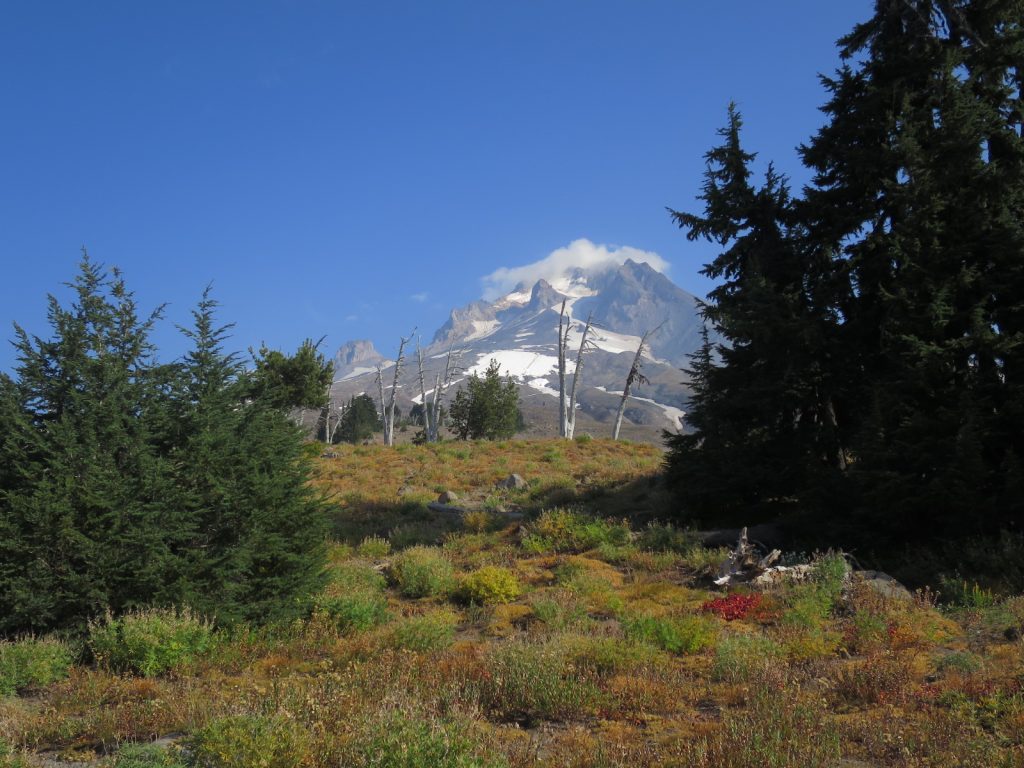
11. A view of Mount Hood from the Timberline Trail which circumnavigated the 12,000 foot conical mountain at the treeline.
There is a 4 day trail which circumnavigates Mt Hood called the Timberline Trail. It was quite demanding because of the ascent and descent in it, as it crossed over all the side ridges which came down from the summit cone. The PCT followed this Timberline Trail for a good few hours or 10 miles, at around 5-6000 feet.
It was nice walking through the top of the forest, mostly of Mountain Hemlocks and hardy true Firs. Mountain Ash scrub was scattered through the clearings and around the base of the trees. Every so often the path came to an abrupt halt and one looked down into a massive eroded ravine with white sides. I assumed this was where the ash, or pumice, which made up much of the volcano sides was eroded. The path either descended into it and climbed the far side or descended the forested ridge to find an easier way to cross the ravine and then climb up the far side. The ravines looked very inhospitable with the soil being too loose and steep for vegetation to take hold.

12. The 2100 mile mark on the slopes of Mount Hood
After a couple of hours the path finally dropped down a ridge to the mantle below and left the flanks of Mt Hood. I passed a few Timberline Trail hikers here. I had not seen a PCT hiker for a week now. At the bottom of the ridge was a side loop to the Ramona Falls, a beautiful wispy cascade of fine water which fanned out across a rock face. The waterfall was hidden in the Hemlock forest and was as high as the largest trees here at around 130 foot.
I followed the rest of the Ramona Loop down through a mossy glade to pick the PCT up again. I had hoped all the day’s climbing was done but when I looked at the map I could see I still had 2000 feet of ascent to do over Bald Mountain, a foothill of Mt Hood, before the descent down to Lola Pass where I intended to spend the night. On the descent a light coloured owl flew right past me and then perched on a branch and watched me.

13. The white owl which flew deftly through the trees and sat on a branch to watch me go by.
Lola Pass was the end of the PCT in Oregon. From here to Cascade Locks, which was only about 30 miles it was closed due to a terrible fire caused by arson. I would say goodbye to it and then make my own way off piste down the 30 miles to the town of Hood River tomorrow. It would be my last days hiking in Oregon.
I knew California would be a hard act to follow but Oregon has disappointed. Unfortunately her best parts of The Three Sisters Wilderness, Mount Jefferson Wilderness and the Eagle Creek Trail, between Lola Pass and Cascade Locks were all closed, so it is unfair to dismiss her. But this year was an especially poor and frustrating year to be a hiker in Oregon with no views, endless and often mundane forests, and virtually no hikers as they all abandoned the State to skip up north to Washington. I must admit I will be glad to be out of Oregon as I found it quite boring.
I woke early at 0400 to an very unusual sound. Water was dripping off the trees I was camped under onto the tent. I had not seen rain for over 120 days and just took sunny weather for granted. It was just 0400 and I wanted to get going early, so I was soon wandering down the gravel road NE from Lola Pass with my rain jacket on and touch beam shining into the drizzle.
This weather was exactly what the 1000 or so firefighters working on the local fire Eagle Creek fire just over the ridge wanted. It had apparently already burnt 35,000 acres in the last week since a hoodlum started it by throwing a firecracker into the forest.
I walked for an hour and a half in the dark until I could turn my torch off. By then the drizzle had stopped. I was now in a heavily logged valley with mist hanging on the hillsides on each side and reddening maple leaves dripping water beside the road.
This road soon merged with the Lost Lake Road, a paved road with a yellow line down the middle. After a few miles a pickup came towards me a stopped. An extremely friendly avuncular man asked me a few questions about my detour and inquired if I needed snacks and told me he had seen many deer and bear migrating away from the fire over the last few days. He kindly gave me a handful of snacks. Only then did I notice the writing on the side of the truck. It said Hood River Sheriff. He was perhaps the friendliest policeman I have ever met.
I followed the Lost Lake Road for a good 10 miles to the fruit growing community of Dee. Suddenly the forest was replaced by orchards; pears, apples and huckleberry/blueberry were all growing well here under the imperial gaze of Mt Hood which dominated the skyline to the south. There were grander orchard houses where the owners or managers lived, and then shacks with older cars and small fields of maize where the probably Mexican workers stayed. It was an interesting cultural landscape.
At Dee the road got busier. I hated it. Beside the road was an old railway track which was probably just used to transport fruit. It was in poor shape, and the tracks were rusty and the sleepers wobbly. If a train used them it would have to go very slowly, so I decided to walk on it as it paralleled the road for a few miles until it veered off and I returned to the highway 281.
I had done about 20 miles now and was getting thirsty, but the creeks were now muddy rivers and not inviting. I then saw some flags ahead and as I approached deciphered they said open. It was an antique shop but they also sold Ice Cream and sodas. I went in curious to see what Americans class as antiques. Once I entered I became the oldest thing in the shop, it was mostly bric a brac and collectibles from the 60’s and 70’s. However the Ice Cream from the Tillamook Dairy was the best I have tasted. It was a renowned brand.
The next 3-4 miles of road walking were unpleasant but eventually I got to the outskirts of Hood River and could escape the main road and follow leafy side streets in posh neighbourhoods. I phoned a bed and breakfast which had a bunk room and they had space, so I now had somewhere to aim for.
When I reached the bed and breakfast and went in I was overwhelmed. The couple who ran it, Pat and Anne, were part of the cool windsurfing and kitesurfing scene in Hood River which was on the world circuit. They had been doing bed and breakfast here for decades and the house was full of signed photos of the leaders of the sport who had stayed here. I am sure back in the old days it was a rougher, crash pad for the competitors, but today it was a sophisticated and chic with the friendliest hosts you could conjure up. They offered me craft IPA beers and invited me to join them for dinner with a few other guests. How my fortunes had changed from trudging down beside the highway to listening to tales of windsurfing antics and feats in a gorgeous house.
Meanwhile my packages were hopefully being transferred from Cascade Locks, which was still evacuated due to the very real fire danger, and Anne had contacted someone who could help me over the Columbia River. There was a bridge but it was prohibited to walk or cycle on it. One had to go in a car across the mile long bridge, and as a purist I could not do that. Anne’s friend had a kayak and that would do perfectly.