The Cape Wrath Trail. Section 02. Torridon and Fisherfield
April 25, 2018
5-10 May 2018
I left the Kintail Lodge Hotel and walked east along the road pavement for a km and then took the road to Morvich. The rain at breakfast had subsided and there was even a hint of blue sky. Morvich was a small village, which since the building of the causeway time had forgotten. I walked through it for a km and then crossed an old stone bridge over the river before turning east.
The patches of blue skies grew ever larger as I walked up Strath Croe looking down onto wonderful green fields full of sheep and lambs and surrounded by parkland deciduous trees. I could look right up to the north side of the angular Five Sisters ridge which still had a lot of snowfields on it. Across the valley was Ben Fada with its steep corrugated flanks rising up to a jagged ridgeline. The patches of sun grew as I walked up the glen into the forestry plantation for 2 km.
I popped out of the forestry and started to climb a steep hillside to the east. The slope eased before the pass at the Bealach na Sroine. By now the sky was predominantly blue and I could feel it burning my legs and scalp slightly. There were grand views here over a vast and very empty country. Just below me to the east was a large burn in a hanging valley. The stream plunged of the edge of this hanging valley to form the biggest waterfall in Britain; The Falls of Glomach.
I hurried to the valley floor where the water rushed off an edge and into an abyss. It was so far down I could not see the bottom. As I admired the falls Lucy arrived, she was doing Scotland’s National Trail, a convoluted 6 week hike through Scotland. She had already walked round Britain’s Coastline over 13 months. We went down to a view point and I realised what I initially saw was just the top fall. The main falls were below this in a deep, deep chasm. In all they must have been 100 metres of near vertical fall.

27. Looking down the spout of the Falls of Glomach. These falls tumble a good 100 metres and are Britian’s highest falls.
Lucy and I climbed back up to the main path and then descended to the floor of Glen Elchaig, a large beautiful valley with some fields and forests on the floor where a lazy river meandered deep bends. We found a place out of the wind and had lunch beside the river.
It was a short walk up the beautiful pastoral valley past Canach farm and on to Iron Lodge. We spotted a cuckoo flying between copses looking like a sparrowhawk. At Iron Lodge the path headed north up a large side valley. The climb was sustained for nearly an hour until it reached a pass between two large Corbetts, mountains over 2500 feet. The sky had now clouded over and rain looked likely.

29. Maol Bhuidhe Bothy with a stomy evening about to arrive
We hurried down the north side of the pass towards Maol Bhuidhe bothy and only just beat the rain. I had walked for 8-9 hours and 23 km but was not that tired. There was already 5 people in the bothy including Craig and Bernard. The conversation did not flow as well tonight as other bothy nights. As we settled down the wind got up to near gale force and the rain was being driven in sheets. It was a miserable night outside and very cosy in a warm sleeping bag listening to it batter off the tin roof when the wind roared. Long after I settled and as it was getting dark 4 others arrived from Shiel Bridge and squeezed onto the floor.
Apparently they settled in Bernards and Craigs room, the only wood with a fireplace, and lit a fire with the coal they brought. They then started drinking whiskey and talking loudly until 0130, when the girl amongst them threw up. I slept through it all but when the gentle Craig told me in the morning I reprimanded them throwing in the odd expletive for effect.
I left around 8. Bernard had long gone having had a poor night’s sleep. Lucy and Craig were heading north to Gerry’s Bunkhouse at Craig. My route would take me to Strathcarron and a bothy 8 km north of it. I said goodbye and headed round the east side of Beinn Dronaig as I knew the route and south side was likely to be boggy. It was not quite drizzling but it was damp and the mist hung atmospherically in the valley.
Once I rounded the shoulder I saw Loch Calavie it was completely still and without ripple save for the occasional rings of fish rising. It was a very peaceful walk round the lake. It was completely silent save for the gurgling of a few small streams. Just a few sandpipers flying from point to point disturbed the scene. The low cloud hung over the loch in patches and it was a magical setting.
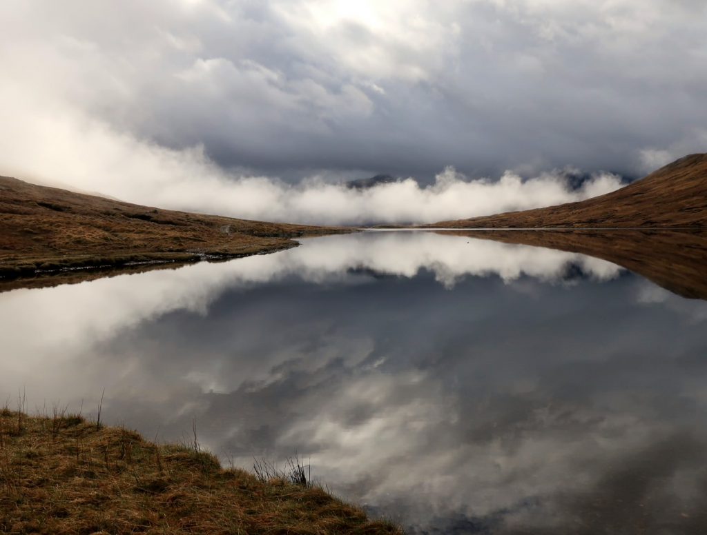
30. The mists slowly lifting on the silence of Loch Calavie on the north side of Ben Dronaig mountain
By the time I reached the end of the Loch and had dropped down to the bothy at Ben Dronaig Lodge the cloud was lifting and shafts of sun were breaking through. There was a couple at the bothy and I chatted with them while I ate my Bombay mix.
By midday I was of again for the quite dull walk to Strathcarron. The sky was definitely clearing now and at the highpoint I could see the snow covered Black Cuillin ridge on Skye some 40 km to the west. On the final section to Strathcarron I crossed a stile over a deer fence and entered an area of natural regeneration. The saplings here were unfolding their summer foliage and the area was full of birdsong. In a few weeks these saplings would host millions of insects and the birds would be able to feast and perhaps raise 2 broods.
I stopped at the hotel for tea and cake as the opportunity seldoms presents itself so easily. After that I walked over the bridge spanning the River Carron and followed it’s curves up for a couple of km through the well tended fields of New Kelso farm. The fields were lush and green and full of sheep which were lambing. A diligent shepherd was walking amongst them looking for sheep with lambing problems.
This riparian path led me to the main road which I had to walk along for a km to Coulags. Here a path headed north for 3-4 km up a narrowing valley as the high mountains of south Torridon encroached on it. The valley continued but i had reached the bothy a Coire Fionnaraich, my goal for the day after nearly 30 km and 11 hours. It was a very picturesque bothy with two full floors and a chocolate-box facade.
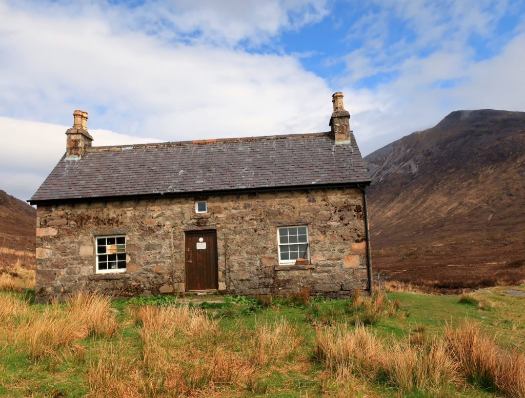
32. Coire Fionnaraich Bothy on the sunny morning of the night i stayed. It is perhaps one of the nicest bothies
I went in to find Bernard. He was the only other occupant. We dined together and then took a room each upstairs hoping no one else would arrive in the evening as they did yesterday. For the second day in a row once I was ensconced in the bothy the wind and rain started to lash down. I peered out of the window with the rain flowing down the panes and felt lucky to be inside.
I slept well and woke briefly to hear Bernard leave at 0600. Then slept again until 0900. The weather was a misty and damp but not quite raining. I lingered in the hope it would improve and left at 1100. By now the mist was only covering the highest tops.
I bounded up the trail to Loch Coire Fionnaraich under the sandstone tower of Maol Chean Dearg mountain. Here the trail climbed to a saddle and split, with the NW branch going over a pass and down to Torridon village and the NE branch traversing gently up to another pass. I took the latter, crossed the pass and then descended a boggy pathless tract for a few km until I picked up a new parh down to the Ling Hut in Glen Torridon. On the descent I got some birds eye views out to sea and the isle-studded Loch Torridon
On my route down I was in awe of 2 of the 3 giants of Torridon, namely Liathach (pro: Liatach) and Beinn Eighe (pro: Ben A). Liathach is a very impressive mountain rising 1000 metres in a series of ramparts to a castellated ridge. Beinn Eighe is as big, but not as foreboding from this angle.
They like most of the mountains on the west coast north of here are composed of Torridonian Sandstone. It was laid down in a layer a few kilometres thick on top of the ancient bedrock of Lewisian Gneiss. The Torridonian sandstone was laid on top of the gneiss 800 million ago when this area was delta of a major river system, like the current Mackenzie river of today. Indeed this part of Scotland was part of North America then. Since then most has been eroded leaving these monoliths.
As I approached the Ling Hut in Glen Torridon the path weaved its was through a puckered landscape of moraine debris. There were humps and divots everywhere left by the retreating glaciers 10,000 years ago.
I crossed the road in Glen Torridon as the long threatened rain finally arrived. The mists which had been enveloping the hills all day consumed them, and heavy drizzle started to fall.
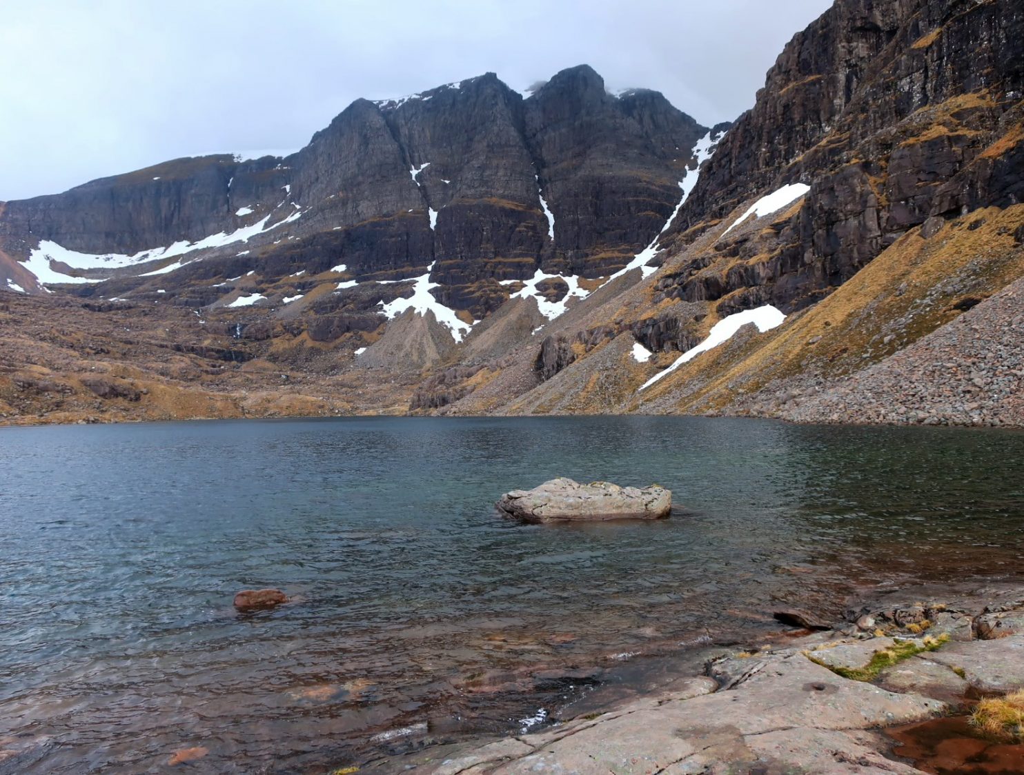
It was wet all the way up the valley between Liathach and Beinn Eighe, past the stepping stones over the burn and to the path divide. However, somewhat miraculously as I came round to the north side of Beinn Eighe it stopped raining and even cleared when I got to my destination at the fabled Coire Mhic Fhearchair, home of the Triple Buttress crags and one of Scotland’s top climbing venues.

35. The triple buttress in Coire Mhic Fearchair on Ben Eighe. I camped near here.
I went up to the loch to find somewhere to camp but it was too gusty for my lightweight tent and there were no good pitches. So I lingered enjoying the view and then retreated back down the path beside the waterfall and found a good spot to camp. There were some dramatic views over the flat landscape, strewn with small lochans glowing in the light with the steep, dark monoliths of sandstone rising from them.
The wind did get up in the night and the tent flapped and woke me up frequently despite my 8 hour walk. Luckily it didn’t rain- that was forecast for tomorrow mid-morning so I rose at 6 to get packed and under way before it arrived.
There was no path and I had to gingerly traverse down the steep mountainside. It was steep unstable ground with sandstone boulders and tall heather. Easy to twist an ankle or plunge a leg into a stone hole and fall. After an hour I was down and found some faint deer tracks south of the valley floor.
I followed these east along the north side of Beinn Eighe for an hour past 2 deep wild corries. This was wild country and i did not expect to see anyone else here. On one stretch I followed the crystal clear river up past meanders cut into sandy banks. This Torridonian sandstone weathered readily producing redish sands along river courses and around lochans.
As I started the gentle climb up the head of the valley the terrain changed from sandstone to quartz. This was due to a later geological event, long after the Torridonian was laid down. Here I noticed the ground was covered in dwarf juniper which had been nibbled by starving deer. The prostrated juniper shoots were easy to mistake for club moss.
At the top of this shallow pass the rain arrived in ernest. It was coming in sheets being driven by the wind like a giant net curtain being pulled. It was to my back so I carried on down the slope keeping to the south of a ravine which was forming. It was slippery on the grass in my lightweight boots and i fell a couple of times. A path soon appeared from the north side crossed the ravine and came up to where I was.
I picked it up, crossed a deer fence and had a lovely descent down to Kinlochewe in an area of regenerating mixed forest with some grand old venerable pines, which were established before deer rampant 100 years ago. At Kinlochewe I found a cheap room at the hotel and before long was soaking in a bath while scrubbing my clothes. It seems the others, Craig, Bernard and Lucy might have already passed through Kinlochewe while I did my Torridon diversion.
After a very relaxing stay the Hotel i was eager to continue. However the forecast was for drizzle all day, which was a great shame as I was going to walk through another stunning area. Last time i did this walk I went up the postal route along Loch Maree to the south side of Slioch and then cut over to Loch Fada, so this time i wanted to go the south route by the Heights of Kinlochewe.
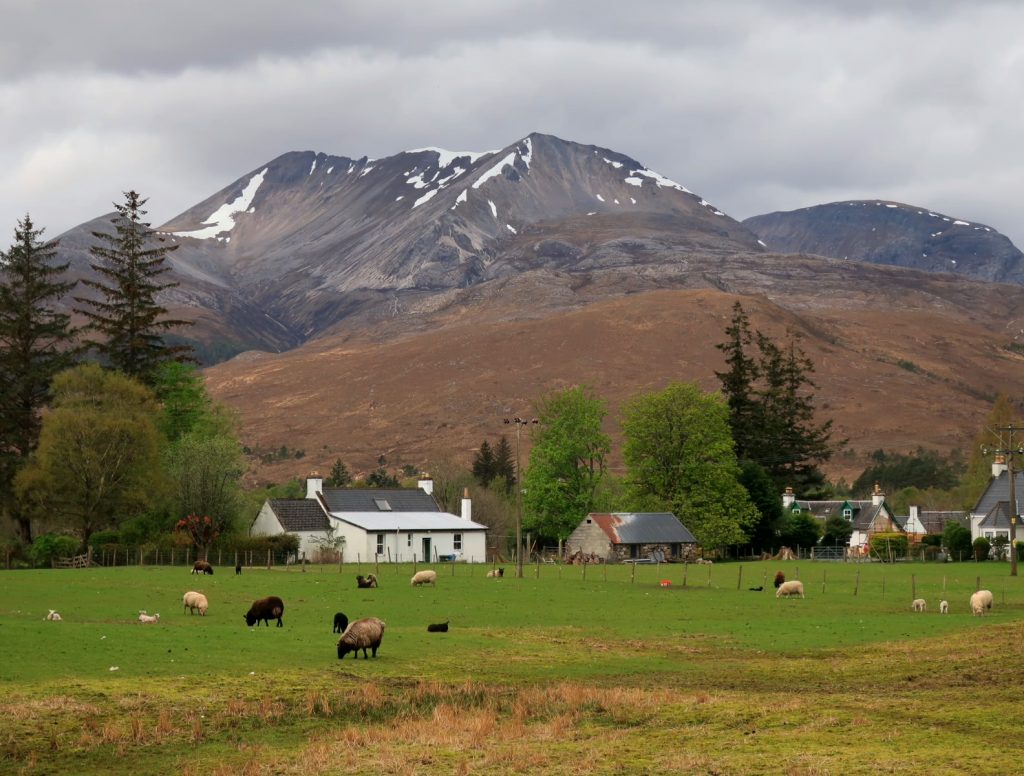
38. Leaving Kinlochewe with the eastern end of Beinn Eighe in the background
I followed a few lanes to the start of the large new track. It seemed there had been a few micro hydro schemes built up this valley and this was the construction road. It was large and a bit violent for this gentle valley.
However the hydro schemes seemed to be greening over and within time they might be unnoticed. It was good to see however how the whole valley had been fenced to keep the deer out, and seeded some 10 years ago and it was now full of vigorous saplings.
The track continued nearly all the way to Loch Fada and surprisingly the weather stayed dry. Even the visibility was not to bad and most summits were visible. At Loch Fada the trail stopped and I headed north up the barren hillside.
There was a line of crags and last time I went to the east of them and ended up in a maze of peat hags. This time I went to the west of them which involved more climbing but I avoided the difficult boggy terrain.
It drizzled a bit, but the summit but the views remained tolerable. Munros (3000ft) and Corbetts (2500ft) rose all around me with the silvery slot of Loch Fada between. The descent down to the pass was slippery due to the drizzle and my inadequate footwear.
I got down to the pass and then followed the stream keeping to the west of it. Loch Bhraoin ahead offers an easy escaped to the road, but I headed north to Loch Nid and on down to Auchnagatt.
It was a lovely easy fast descent and I felt good. There were some hugh bare slabs on the slopes of the mountains to the west which were smooth and bare for 500 metres. At the bottom of the valley by Auchnagatt there was a lovely forest of alder beside the river. Beneath the trees was smooth short cropped grass, ideal for camping with the iconic mountain of An Teallach watching over.
Here I met Brian, who was doing the 6 week Scotland’s National Trail. He was with 2 friends and they were all heading to Shenavall bothy like me. There were all from the fire brigade in Stirling and also in the Ochils Mountain Rescue Team. We had mutual friends.
By now the rain was on but the visibility remained. I walked the last couple of km quickly and got a nice place to sleep upstairs. The firemen had brought in wood and soon had a fire going. They were the life and soul of the evenings banter with the young French and Germans a bit bewildered. Outside the weather was much improved with the sun setting around 9. Deer grazed in the pastures around the bothy while the peat smoke hung in the air

40. Brian and the firefighters from Stirling outside Shenavall bothy. In the distance is Carn Dearg Mor mountain
It was a glorious morning but with lots of blue sky, but I could see a shower had just passed and the window panes were wet. The hinds still grazed on the pasture outside the bothy. Beinn Dearg Mor was looking magnificent with its very steep gullies still full of snow. I ate breakfast with Brian and the other two fireman and set off up the initially steep path at 9.
Soon the path eased and it became boggy for a few km until I got to the track. A rain shower approached quickly from the SW obliterating all before it. When it enveloped me I realized it was largely hail and I rushed to cover my rucksack and put my jacket on. The hailstones were stinging the backs of my calves as I had shorts on. Luckily it passed as quickly as it arrived and I was soon bounding down the track into the budding birch forests in sunshine with birdsong ringing out. Surprisingly there is never a great view of An Teallach from this track.
I reached Corrie Hallie to find the 3 firemen having lunch. Brian was continuing but the other two were heading back to Stirling. I walked down to the chocolate box bridge over Dundonnell River and paused for lunch in the sun. As soon as I finished another shower rushed in from the SW. Initially the route went up an old stalkers path which was now grassed over. As I left the treeline of vibrant green birch I looked over my shoulder to a wonderful view of the whole An Teallach massif. An Teallach is rightly one of Scotland’s most iconic mountains and this must be one of the best viewpoints of this jagged crenellated ridge.

41. The mountain of An Teallach from the ridge between Little Loch Broom and Loch Broom
The path headed up a side valley and then headed over the apex of a ridge by a small loch where I saw a couple of Plovers. There were a few cyclists coming down this way as this was part of the NW550 cycle cross route which is becoming very popular. From the loch the descent to Loch Broom began.
The Loch cut its way inland from Ullapool between rounded hills. It stopped below me the head of the loch fringed with yellow gorse. Inland from the gorse were lush green fields across the valley floor. As I chatted with another cyclist, Fritz the Dutchman with a collie caught up. I had chatted with him briefly yesterday and we continued as we went down the path to the fields.
At the bottom Fritz headed to the bridge over the River Broom while I headed south along a lane through the Inverbroom Estate. It seemed very well managed and had had a lot of money spent on it. The fields were perfect and surrounded by parkland trees. Every field was full of sheep with lambs, usually twins.
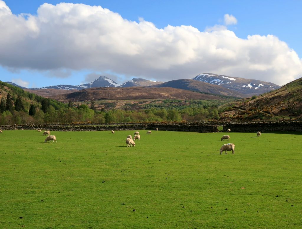
43. Sheep in the lush fields of Inverbroom with the Fannich range of mountains in the distance
I followed this lane for 3 km until I reached Auchindrean. There was a small bridge here over the large River Broom which I crossed to reach to the main road. Luckily there was a forest walk on the east side of the road which I followed for half a km to reach the Forest Way Bunkhouse at Inverlael. There was no one around but I had been told earlier just to go in and make myself at home. On the table was my resupply box with food for the next 5 day to Kinlochbervie. That evening I was joined by 3 other hikers. Section 2 which had been a lot wetter than I wanted was at an end.