Section 05. Everest Region

April 29. Chhukhung to Lobuche. 12km 6.5 hours. 1100m up. 988m down. I wanted to get an early start today to go over Kongma La Pass. Most groups leave at 0600. However the team was also splitting up for a week with Bharat taking all four porters down too Namche Bazar and then on to Thame where he would wait for about three or four days for Dawa and myself who were going over The Three Passes of Everest, Namely Kongma La, Cho La and Renjo La, before meeting the others at Thame after our six to seven day excursion. It is not really clear if Dawa’s and my route over the Three Passes is part of the GHT or not but in the spirit of the GHT to go the highest route possible they should be and as such I am including them.
Bharat and the four porters are taking virtually everything, leaving Dawa and myself with the luxury of 8-10 kg rucksacks. We hope to travel fast and light. I decided to give the others an allowance of 1000 rupees a day to buy food and cook it. So I had to count out 30,000 rupees for them. Plus give Ramesh another 15,000 to buy food for the Tashi Labsta Pass after Thame. Plus give Ramesh another 5,000 to fix the stove, buy a holdall kit bag and some factor 100 sun cream for my fried lips. Then I had to pay my bill at Sunrise lodge plus the Nepali food bill for their stay in Chhukhung which together came to 22,000. So all in all it was an expensive morning with about US$700 shed. Once all this was done it was about 0930, and Dawa and myself eventually set off at 1000.
It was a fantastic morning as we started up the hillside with our backs to the very fluted ridges and vertical faces of Ama Dablam. Ahead of us was the south face of Lohtse, one of the most formidable faces in the Himalayas. We chatted a bit but I soon realised I needed my breath for the climb and had none to spare for chat. We climbed quite quickly through dwarf juniper scrub and steep yak pasture. Here people were collecting the dung to sell to the lodges. At one point Dawa got a phone signal, so held back to chat to his family whom he had not spoken to for about three weeks.

125. Climbing up to the Kongma La Pass gives a great view down the Lower Khumbu Valley past Dingboche and on to around Namche Bazar.
I felt great as long as I kept a steady pace. I was well acclimatized, my pack was half its weight and the sun was out and the streams crystal clear. I passed through the yak pastures and got a good view up the valley to the large and dangerous glacial lake Imja Tsho and down the valley to the roof tops of Dingboche. I then entered a cirque, formed by a long gone glacier, which was sunny, moist and verdant. There was a steep climb out of the cirque to the west and this took us up onto a platform where there were a number of small lakes, all of which were still frozen over. There was very little snow here around the lakes and spring was making ground. Indeed it was amazing we were 1000m higher that this time two weeks ago when we were thigh deep in soft wet snow. Just after the lakes there was a steeper climb up a craggy hillside to the pass. Just to the south of the pass was a trekking peak called Pokalde.
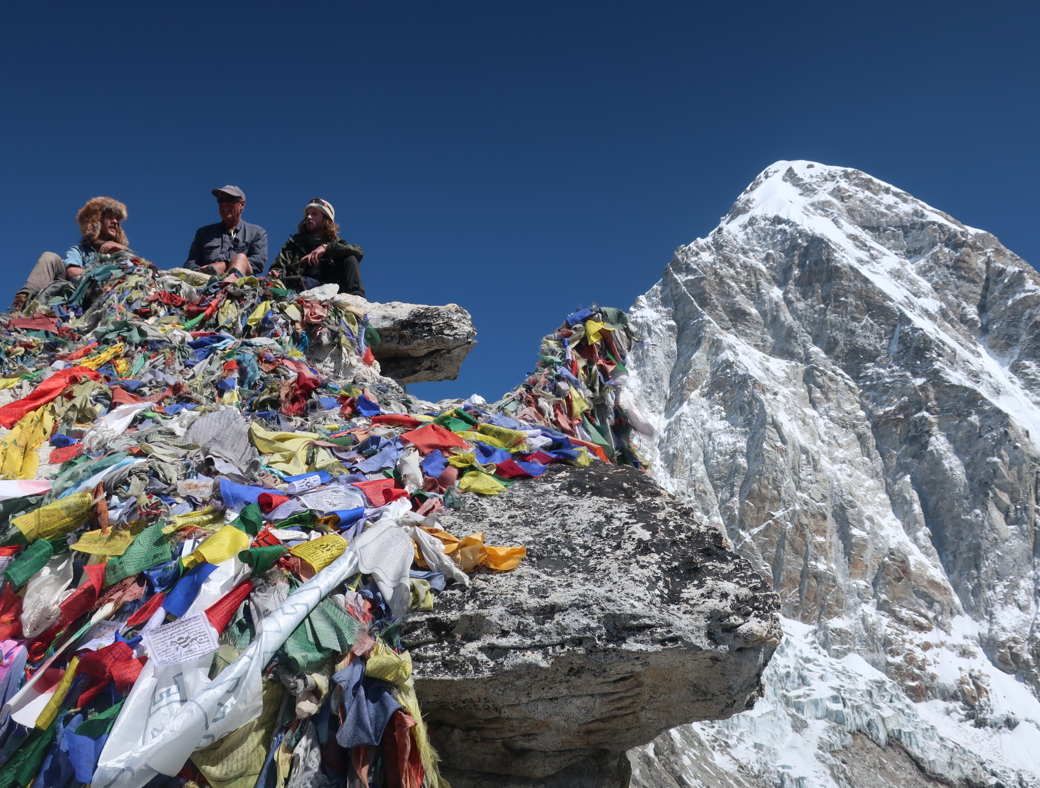
Dawa and myself arrived at roughly the same time as he steamed up the slope behind me. We sat at the top and had a snack and enjoyed the view. Lobuchewas clearly visible down the other side but it was a long way away. We had taken just three hours to get up to this 5535m pass, climbing 800m from Chhukhung. The light rucksack and my fitness were paying off. The usual midday mist was somewhat delayed today and the peaks across the Kumbu glacier were barely affected. After our break, during which we were surrounded by sparrow type birds hoping for crumbs, we started the descent.

126. Looking west from the top of Kongma La pass down to the near stagnant and moraine covered Khumbu glacier and the hamlet of lodges at Lobuche on the other side.
Initially the rough path went to the north of the descent to avoid crags. The path then started quite a steep descent down small zig-zags on the north side still as it descended rapidly. There was no snow at all and the path was well established. Indeed we caught up with two other groups who were doing the now popular Three Passes. The path then moved to the centre of the valley as it descended quickly to the Shangri-La at the bottom of the valley. This Shangri La was the sandy established grove which ran between the devastation of the Khumbu Glacier and the mountainside, hemmed in between moraine wall and rock. It looked like there had been no upheaval here for a few hundred years and the terrain was of sandy pasture. It was warm and sunny with great views to Pumori. In the summer this area is teeming with yaks grazing.

127. Looking back to the Knogma La Pass from the devastation of the Khumbu Glacier. The descent route is on the scree to the centre left of the picture.
However we still had to cross the Khumbu glacier to get to Lobuche. It was a km of geological chaos on a biblical scale. A vast river of ice which once moved and was replenished with fresh ice had now become stationary as it sat in its trench. The dormant beast was now slowly dying but it would take many decades for all the ice in the trench to melt. Most of it was covered in metres of stone and boulders which insulated it, but it still was melting under this coating. As it melted the rock coating moved and collapsed and lakes formed, so the path was a temporary ever changing route. As we followed it we strayed once to find ourselves on top of huge boulders which were actually precariously perched on top of an overhang of ice some 30 metres high. It was a very dangerous area and we retreated quickly to find the path again. Eventually after a short hour we climbed up the moraine on the west side and left the glacier behind. In 50 years the terrain we had crossed could be 100 m lower as the ice vanishes.
Lobuche lies in the Shangri La between the glacier and the mountains on the west side on a high pasture. It is not a pretty place and has grown rapidly since was here some 12 years ago. I did not recognise the place I stayed at last time – every small teahouse from that time had grown into a two storey charmless hotel, and they were crammed together. Dawa tried Oxygen but it was full so we got some characterless rooms in the hotel beside it. Tomorrow we would just do a day trip up to Kala Pattar to get a good view of Everest and then return to Lobuche again.
April 30. Lobuche to Kala Pattar and return. 18km. 7 hours. 940m up 940m down. Dawa and myself arranged a breakfast at 0530, but when we got down discovered the cook was still asleep. He got him up and we had breakfast at 0600 and left by 0630. There was a bit of cloud about, and I was concerned the overcast afternoon was going to arrive early. There must have been at least 200 people leaving Lobuche at this time. All the tourists, including me, had trekking poles, all the guides had their hands in their pockets and a scarf over much of their head and all the porters had about two large holdalls strapped together and hanging on a headband. The tourists were by far the more cumbersome and awkward in their gait. Dawa and myself were hardly taking anything as we were returning to Lobuche so we had a fast pace and soon overtook the majority.
The path went up the sheltered grassy valley between the lateral moraine and the mountainside for a good 3km before it climbed up onto the apex of the moraine ridge and followed this. To the east we could look down onto the Khumbu Glacier which was largely covered in rocks, except in places where there were steep walls of ice. It did not take long to negotiate this braided path as it continued its gentle climb to Gorak Shep. Ahead rose the steep, bulbous south side of Pumori, a 7000m neighbour of Everest, which was still hidden by its other neighbours. The crowds were left behind but there was a background buzz of helicopters, and we were now meeting the crowds who were leaving Gorak Shep that morning, along with a couple of stray dogs who were following them down.
After an hour and a half we crested a rise in the moraine, and there was Gorak Shep below us. It had grown considerably since I was last here in 2007 when there were perhaps three or four single story lodges. Now there were five or six three storey lodges. They were all clustered together on a moraine mound, while beside them was a flat sandy area about twice the size of a football pitch. It did not look a very homely place and with the odd cloud still hanging around we decided to carry on up to Kala Pattar and stop here on the way back.
128. Sitting on the prayerflag festooned rock at Kala Pattar with the 7000m of Pumori in the background.

129. Mount Everest, 8848m, on the left and Nuptse, 7861m, on the right, as seen from Kala Pattar. Between them is the Western Cwm leading up to the South Col.
The climb up to Kala Pattar also took about an hour and a half. There were lots of people coming down who must have all gone up for the sunrise thing. About one third of the way up there was a landing place for helicopters doing expensive mountain flights. They were a nuisance and an intrusion and I lament the fact they are allowed inside a National Park. As we climbed towards the south ridge of the now looming Pumori, more and more of Everest started to appear behind Nuptse and its formidable West Face. About half way up and well above the helicopters I looked down onto the Khumbu glacier just below the infamous Khumbu Icefall and was astonished to see the whole of the west side of the Glacier was covered in about 1000 yellow, orange and red tents. It looked like a music festival. Dawa told me there were perhaps 5000 people down there with massive amounts of kitchen tents and sleeping tents for the thousands of Sherpas. He had relatives who had worked here. It was a bit of a horrifying sight and confirmed rumours I had heard about the whole ascent of Everest being something of a circus. Last time I was here 12 years ago it was November and I suppose all the tents had gone for the season.
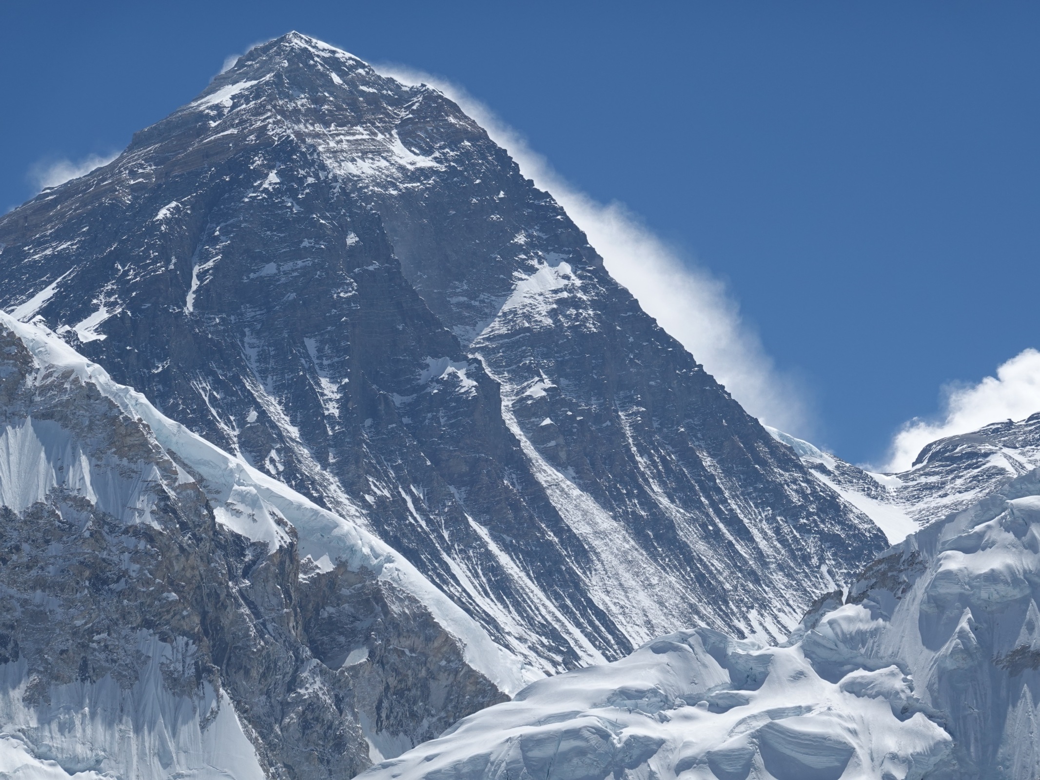
130. The South West Face of Everest as seen from Kala Pattar. The South Col is just visible on the right hand side.
I did my best to ignore the distant sight and carried on up the easy path and reached the top some three hours after leaving Lobuche. Having no rucksack and being well acclimatized was a huge advantage. It was a great sight; almost hair raising to look across the valley into the heart of the Kumbuu Icefall and then follow it up to the Western Cwm all the way to the South Col. You could even make out what might be a few features like the Hillary Step. The North Ridge which rose up from Tibet was also clearly visible, and this looked to be a much easier way to ascend. It was an immense mountain vista, perhaps one of the most spectacular an ordinary mortal can see without venturing up on of these giants. Dawa and I chilled out on the rocks taking it in for a good half hour, fortunate that the clouds which had threatened three hours earlier had vanished.

131. Recreating a photo I took 12 years ago from Kala Pattar, looking over to Everest and Nuptse.
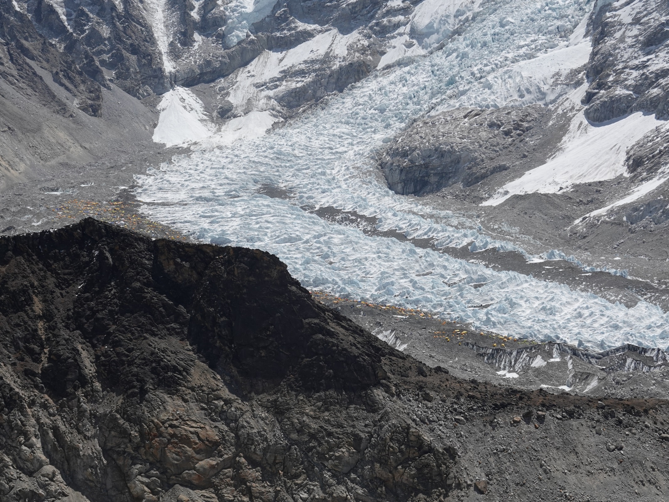
132. At the bottom of the Khumbu Icefall in the Western Cwm and on this side of the glacier is Everest Base Camp. If you look carefully you can see perhaps 1000 tents on the moraine with at least 5000 cooks, Sherpas, porters, climbers and logistics personal. It is a popular trekking destination but this circus of egos is probably best avoided as there is no view, in favour of a trip up Kala Pattar where there is a great view.

133. Looking SW from Kala Pattar across the glacier to the Lobuche peaks which are popular trekking peaks. The other side of that range are the lodges at Dzongla.

134. Looking south from Kala Pattar down the devastation of the Khumbu Glacier. This vast stream of ice is now near stationary and the surface moraine is covering probably 100m of ice which will melt over the next 50 years.
We quickly descended back to Gorak Shep and went for a meal. In the lodge were two English ladies I had met the night before. They were spending the night here. I joined them for lunch before they left to go to Everest Base Camp. I told them about the tents. Dawa and I then sauntered back down the valley to Lobuche, hands in pockets as we skipped from stone to stone chatting. Dawa told me about his family which had endured a bit of turmoil over the years. He as the oldest brother was essentially head of the family now since his father was killed in an accident a decade ago.

135. Heading down the Khumbu Glacier towards the west turn off to the hamlet of Dzongla it is usual to meet Yak caravans heading up with supplies. Pumori is the mountain in the background.
I did harbour thoughts about continuing on to Dzongla, something I could see Dawa was uncomfortable with as he had already booked a place at Oxygen Altitude Home, the place to be in Lobuche. By the time we reached Lobuche it had completely clouded over and the thought of another three hours in drab grey overcast conditions with the possibility of mist or even snow was not inspiring, so I decided to stay at Oxygen. The room was nice but it was the dining hall which clinched it. I immediately bumped into an Irishman who was witty and chatty. In fact the whole place was vibrant with chat and I knew II would enjoy the night here. Tomorrow would be a short three to four hour day to Dzongla where I had stayed 12 years ago, but by now it had probably morphed into a hamlet rather than the cosy lodge I remembered.1 May. Lobuche to Dzongla. 8 km. 2.5 hours. 180 up. 260m down. Today was going to be an easy day so I lingered in bed and did not get up until 0730. I packed and then went down to the dining hall for breakfast. The place was deserted with everyone having already departed, most for Gorak Shep. I had ordered macaroni for breakfast and when it came I regretted having done so, especially as it was in a water tomato sauce. By the time I paid the bill and we set off, hands in pockets, it was 0830. It felt we were the last to leave town. The sun was out and it was a glorious day as we sauntered down the path chatting. Hardly anyone came towards us, and we passed no one as we cruised down the small valley between the mountainside on the right and the huge glacier on the left for about half an hour until we got to the junction. Ama Dablam and Thamserku dominated the landscape down the valley beyond the small village to Periche, which was huddled in against a large moraine wall.

136. Looking down the upper Khumbu Valley from near Dzongla to the two giants of the eastwern flank namely Ama Dablam, left, and Thamserku, right.

137. Ama Dablam, 6856m, is rightly one of the most famous and photographed mountains in the world. This impressive view does not show of her best features.

138. Thamserku, 6608m, is the other spectacular giant on the east side of the Khumbu Valley.
We now started to traverse across the west side of the valley which it dropped away beneath us. The more we traversed, the higher above the Khumbu valley we climbed on the smooth hillside in the sunlight. After a good km the path crossed a parched spur and then started heading up a side valley, possibly called the Cho Khola. The path continued to traverse up the new valley high above the valley floor which was covered by a lake, caused by the damming of the valley floor by a huge alluvial fan which seemed to have material added to it by frequent rockfalls. The lake looked shallow but a larger rockfall might block the valley further, causing the lake to grow to a depth of over 20-30 metres and then it would be a real danger to Pheriche hamlet if it burst.
To the south and north the Cho Khola was flanked by very impressive mountains. Lobuche East and West to the north were trekking peaks and Dawa could make out a party climbing the former but I could not see them. On the south of the valley, the other side of the lake was Tabouche, which Dawa explained meant Saddle in the Sherpa language. At the head of the valley was the glacier which led up to Cho La Pass, 5420m, some 600 metres above us. As we chatted we rounded a spur and there across the valley on a small spur was a collection of teahouses which formed the hamlet of Dzongla. We descended into the yak pastures, which were currently brown and parched, and then climbed to the collection of green corrugated roofed buildings which were much more modest and cosy compared to their Lobuche counterparts. The yak pastures were brown and empty because it was the dry season, but come the monsoon in eight weeks they would be green and bustling with yak.
Dawa chose a lodge and I checked out the dining room before committing to a room. The dining room is where all the guests would gather in the late afternoon and evening to eat their meal and then chat. This one looked cosy and it had a stove. In the hall there was a huge pile of dried yak dung which would produce a lot of heat. Indeed some 30 dried yak pancakes would heat the whole place for five hours. It looked promising so I took the room. In the afternoon I wandered about the hamlet, which was quite dull as it was just a collection of lodges rather than an organic community, enjoying the sun as the overcast afternoon was late in arriving today.
Other hikers arrived in dribs and drabs. First two who I had met on Kala Pattar yesterday and then two enlightened Americans who I had met in Chhukhung. Then a larger group of younger and socially divergent Americans arrived, some of whom seemed up for a conversation while others retreated onto their phones. Apart from them it had all the promise of a sociable evening. Dawa suggested we get up at 0500 for an early start, and this was exactly what I had been thinking. Tomorrow we would have a long eight hour day and today almost felt like a rest day in preparation for it.
May 02. Dzongla to Gokyo. 15km. 7 hours. 1110m up. 1180m down. We had aimed to set off as early as possible but Dawa and myself had a slow breakfast at 0600 and did not set off until 0700, by which time everyone else from all the lodges at Dzongla had already gone. It was a beautiful day when we set off and I was starting to take it for granted. There was just the off whiff of high cloud in an otherwise blue sky. Arakan Tse, a massively steep mountain rising just south of the lodges at Dzongla, dominated the view but there were mountains in all directions as we set off. We crested a rise and there before us was a high, flat, pastoral valley with a river running down the middle of its meadows. I told Dawa it reminded me of the myth of Shangri la. It was still too early for the yaks to be driven up here, as the grass was parched and dormant, but when it greens in the monsoon this pasture would support a 100 or so yaks and be ringing with the melodic deep chime of the heavy brass yak bells.

139. The Shangri-La like valley beyond the lodges of Dzongla was calm and idyllic and just waiting for the arrival of hundreds of yak which would fatten up on the green monsoon grasses.
Even as we crossed the idyllic meadow towards the glacier we started to catch the slower, cumbersome groups up. At the end of this tranquil meadow the sun started to warm and we took our jackets and fleeces off for the steep climb at the end of the meadow which would take us up onto the glacier. The climb was steep but short, essentially up a shallow gully which was choked with boulders which were stable, dry, and wedged in place. I was gasping for breath as I went up with a spurt of enthusiasm but after 15 minutes I was on the smooth glacier which led up to the pass. Walking on the glacier was easy as the snow was frozen with a crunchy layer on top to grip the soles of my shoes. Dawa and myself sauntered up expanse of snow in beside the frozen footsteps of those who had gone before until the pass suddenly revealed itself just ahead, festooned with prayer flags.

140. Dawa on the glacier just leading up to the Cho La Pass, 5420m.
I had been over this pass before 12 years ago and was surprised to see how much the glacier landscape had changed. Previously there had been a small lake at the pass hemmed in by mountain on the pass side and ice on the glacier side. The glacier had melted sufficiently that the ice dam had vanished and the lake with it. There were some 10 people on the Pass, half tourists and half Nepalis. Dawa knew one of the Nepalis, which is hardly surprising as guides and porters often have worked together previously and then bump into each other on the trail. As they were chatting I went to have a look at the descent as I had heard rumours it was icy and microspikes were essential.

141. Me in sight of the Cho La Pass. There was a small glacial lake here 12 years ago but it has vanished. You can just make out some prayer flags at the pass beyond.
We were one of the first down. Dawa was confident on the snow as it was still frozen and crunchy and the tread on the shoes bit into the surface. However I was a bit more cautious especially as there was some blue ice about. It took some 29 minutes to negotiate the 100 metres or so of snowfield, which was only around 25-30 degrees until we reached the boulderfields. Here we met three or four groups coming up, comprising some 100 people. I was glad we got down through the snowfield before this army polished the icy footsteps. A few people in this parade already looked the worse for the climb and were labouring to make headway. It was going to be a busy and patient day for the guides.

142. Looking east down the valley towards the lodges at Dzongla from Cho La Pass. The glacier in the middle is the one we just came up.

143. Looking back to the Cho La Pass from the west side. After the steep snowfields there were large boulderfields which ended in a huge Yak Pasture which could easily tolerate 1000 grazing yak in the green monsoon.
The boulderfield was extensive and after a good half hour tentatively stepping from boulder to boulder we reached the valley floor. This valley was a huge pasture and Dawa estimated that perhaps a thousand yaks could graze here during the monsoon season getting fat on the lush green grass. At the head of the valley was a smooth glacier which looked like it could lead to a pass over to the Lobuche area. However I had never heard of such a pass so it must be a difficult and barely chartered crossing. We climbed up the gentle slopes on the north side of the valley to gain another smaller valley which took us down to Dragnag. It was a delightful descent on easy terrain. As we approached Dragnag beside the glacier we walked into the middle of a herd of about 50 Blue Sheep. I was astonished by the lack of caution they showed for us. We could virtually saunter through the herd and they just shuffled out of the way allowing us to take photos at will. Previously I have only seen blue sheep at a distance and even then they turned and fled. I suppose the advantage this time is that we were in a national park and they took a lack of human aggression for granted.

144. On the way down to Dragnag we came across a herd of about 50 blue sheep. It was by far the tamest herd I have ever come across, probably due to lack of hunting in a National Park.

145. A mother and lamb look at me with curiosity and no fear as I approach.

146. The lamb feeding from the mother as I walked by.
We arrived in the unremarkable hamlet of Dragnag and picked a corrugated lodge at random for lunch. It was cheaper here than the Khumbu Valley and we gorged ourselves on Momos, a small vegetable filled pastry, either fried or steamed. After lunch we had to cross the Ngozumbo Glacier, similar to the Khumbu Glacier a couple of days earlier, but even bigger and more desolate. The path I previously took was now advised against, and indeed had probably vanished as the ice beneath the surface moraine melted and caused the stones to realign themselves. The path now went up north for a good km and then cut across the vast wasteland of stone debris. Beneath us were probably some 5-10 metres of stone and then 100-200 metres of ice. This ice had by and large stopped moving and the glacier was in decline. Over the next 50 years all the ice would melt and the boulders would settle into the vacated trench. Now as we walked we could see the hideous decline of this beast as it died. Ponds, tarns and small lakes formed all over the place as the melt water was trapped, then these would vanish as a crevasse opened up or boulders rolled into them and filled them up. It would be a constantly changing landscape for the next half century.

147. Me looking across the huge almost static Ngozumba Glacier at the carnage. This glacier is in retreat but vast amounts of ice under the moraine cover have yet to melt and this will take decades.

148. Dawa looking across the Ngozumba Glacier. As the ice under the moraine melts over decades the lip on which Dawa is standing will collapse into the vacated trench, which might be 1-200metres deep.

149. The “Third Lake” at Gokyo was still frozen when we arrived. It lies at around 4730m. Beyond is the Renjo La Pass, 5360m, the penultimate of our 7 Makalu/Everest Passes.
We finally managed to escape its clutches and climb up the crumbling lateral moraine wall. On the other side of this wall, beside the so called “Third Lake”, an azul, and serene lake formed when the lateral moraine of the Ngozumbo Glacier dammed the side valley in which the Third Lake sits. We sauntered down to the village, which was largely composed of lodges, but also included a bakery. We were bewildered as to where to stay, but settled on one I had stayed at 12 years ago. It had greatly expanded, but the sunny dining room with its large stove had stayed the same. Dawa approved as there were some guides already there he knew and I liked it because I heard a number of groups speaking English. We checked in and I got a simple rustic but large and sunny room.
May 03. Goyko Rest Day. 0km. 0 hours. 0m up. 0m down. The cheese rich pizza I at ate the previous evening sat in my stomach and eventually woke me up at about midnight. It felt like a hot coal sitting there burning the lining of my stomach producing the odd eruption of caustic air like a small fumarole. It did not feel right but I tolerated it for four or five hours as it gnawed away and kept me awake. Eventually, as it was getting light around 0500, the eruptions were combined with nausea and the Pizza made an exit out of my stomach through the window and onto the ground outside. The whole episode had weakened me sufficiently that when I went down for me prearranged breakfast at 0600 I could just look at it. I told Dawa I was feeling weak and feeble and wanted another couple of hours in bed before I decided what to do.
The couple of hours was six hours when I felt quite feverish. I eventually got up at midday but I felt quite bewildered. I did not feel sick or have an upset digestive system but I felt quite weak and had no appetite. Eventually at around dinner time I managed to eat a cake but that was it for the day. I went to bed as early as I dared around 7 and to my surprise managed to sleep until 0500 in the morning. When I got up I felt great, a bit thirsty perhaps, but considering yesterday I felt I had recovered.
May 04. Goyko to Thame. 21 km. 9 hours. 830m up. 1810m down. I ate my breakfast enthusiastically and was ready to go by 0700. The only problem was cyclone FANI. It was dumping vast amounts of water on the East coast of India and also Bangladesh, and Nepal was just catching the very edge of this weather system. There were none of the strong winds which the areas around eye of the cyclone were experiencing. Indeed the smoke from the chimneys of the other lodges were going straight up and hanging in the misty air. The only thing Gokyo was experiencing was a light snowfall, which had deposited some 5 cm through the night, and mist with visibility just 200 metres. I felt I could not delay again as each day was costing me well over US$200 in wages for the six Nepalis.
We set off at 0700 and were pretty much the last to leave Goyko for Renjo La Pass. We could enjoy pretty much a clear path which had already seen 50 pairs of feet stamp the warm snow to slush. We passed the inflow to the “Third Lake” where there was a Brahmin Duck feeding in the shallows there which were not frozen. From there the path climbed steadily in the mist and pretty soon we started to catch people up. First was a group of Koreans who were stumbling and sliding in the snow. Their porters however were storming ahead with huge loads. Then we caught up with a large Polish group and realized that we had better slow down otherwise we would be making the tracks in the snow ourselves, which by now was about 10cm and often lying on older soft snow which we were punching through. So we selfishly had a break to let the 10 Poles take the lead again and prepare the track for us.

150. Looking East from Renjo La Pass towards Everest on the left, Lhotse on the right, and Nuptse slightly lower between them.
It took about three hours to reach Renjo La Pass in all but all of it was in reasonably poor visibility in light snow. We could have been peeved by being denied the views but I was conscious of the fact that millions of people were under threat of losing their homes and livestock and some even their lives by cyclone FANI, so by having a hampered view means we go off very lightly. Besides I had already been over the pass some 12 years previously in glorious November clarity and had even seen Makalu from here, which is reckoned to be one of the best viewpoints in the Everest Region for trekkers. The photos in the blog are from this November in 2007.

151. A close up of Mount Everest as seen from Renjo La Pass. The South Ridge in Nepal is on the right and the North Ridge on the left is in Tibet.
After a rest at the top we started down the other side on a fantastic well-constructed path. It was quite slippery in places where other trekkers had been and polished the snow but we were soon first and our shoes bit into the snow as we came down the endless steps. There must have been a forceful group to promote the building of this path (which I also remember from 2007) as there was a huge amount of work and expense in its construction. I imagine the people of Thame and Lumde pushed for it, as without the constructed path the route up to Renjo La Pass from the west would be very difficult across this rough bouldery terrain, and the Three Passes trekking route might just have been the Two Passes. Apparently the path is good enough to take laden yaks over from Lumde to Goyko.

152. A zoom of Makalu from Renjo La Pass. It is perhaps some 70 km away. The current climbing route is up to Makalu 1 on the left from the valley below then down to the saddle and up the ridge.
The beautifully crafted path eventually zig-zagged down to a frozen lake in the corrie on the west side of the pass. As we neared the lake the snow faded and we were able to walk with less caution. From this lake the path then changed character and became more level and with a sandy base. We sauntered down it chatting and quickly walked out of the snow altogether. Indeed flashes of blue sky appeared but were quickly snuffed out again. We passed another lake and continued to descend dropping out of the mist for half an hour as we approached Lumde. This hamlet looked like it was still very much involved in yak herding, and the sheds and teahouses were surrounded by a network of stone walls. Some to keep yaks in and some, like the potato fields, to keep the yaks out. We wandered into the community and could hear the clunking of yak bells all over the place.
We went to a teahouse Dawa remembered and had lunch among the sedentary guests who were waiting until tomorrow when the mists cleared to go over the pass. After lunch the mist returned with a vengeance and visibility was down to 50 metres at the most. It was a great shame as the 7ish km to Thame was rich with a local herding and potato landscape of which we saw virtually nothing. Instead we walked on a fantastically easy sandy path which gently flowed down through hamlets like Marlung and Tarringa with their stone houses and patchwork of fields surrounded by more stones. There was the constant roar of the seldom seen Bhote Koshi Nadi river which we had to cross once to the west side. After some two hours the many walls of prayer stones, chortens and Tibetan inscriptions on rocks got more frequent and we knew we were approaching Thame.
Suddenly there were rooftops below us and the path descended into the midst of them. Dawa told me we had arrived. He found a cosy hotel and went to find the others. They were nearby, having rented a room they could cook and sleep in. They all came down to the hotel to dump their baggage and say hello. It was great to see them again. They are what the US through hikers call a trail family and I was reunited with mine. The next section would really start from here and it would take us over the Tashi Labsta Pass into the Rolwaling Valley and then through more rural terrain to the Bhote Kosi River. I will call this Section Section 06. Rolwaling.
Section 05. Everest Region had been relatively easy. It basically comprised of three 5500 metre passes and a visit to Kala Pattar for a glorious view of Everest. I was spoilt by the luxury of the teahouses and lodges with their soft mattresses and extensive menus. It was also nice to meet so many people from different countries and speak English fluently without measuring my words. However these comforts also had their disadvantages, as the whole area was overrun with tourists and devoid of any meaningful local culture. The next stage, starting tomorrow morning will rectify that!
Section 05. Everest Region. 74km. 32hours. 4160m up. 4790m down.