Cameron Mountain Traverse in Fiordland
GENERAL INTRODUCTION
The following account is of a journey through South Fiordland in the extreme South West of the South Island of New Zealand.
This region is protected as a 1.2 million-hectare World Heritage Area. The majority of this vast wilderness is rarely visited. Only 2 roads and 5 walking tracks penetrate into it, while the fiords allow maritime visits. This still leaves 99 percent of the area beyond the realms of all but the most determined of adventurers and scientists.
In the West of Fiordland 14 huge ice-age glaciers have carved massive, deep and steep sided valleys as they scraped down the mountain ranges in the Central Divide. These glaciers have relatively recently disappeared, and much of their course has been flooded by the sea leaving 14 awesome fiords.
In the center, numerous steep alpine peaks, separated from their neighbours by deep heavily forested valleys characterize Fiordland. Alpine lakes and tarns lie scattered through this idyllic landscape.
In the East the numerous mountains of the central area descend down to large deep lakes which marks the eastern edge of the park. This eastern edge is much drier than the west, which boasts one of the highest rainfalls in the world.

The north of Fiordland is extremely rugged with many of the steep-walled valleys ending in precipitous ends. As one comes South the valleys sides become less vertical and the mountains summits drop from about 2500 meters to 1300 meters, and eventually taper in to sea. However, even in South Fiordland the landscape is still rugged.
NATURAL HISTORY
The substantial rainfall heavily influences the natural history of Fiordland, over 8 meters a year, in some places. In these wet environs the southern beeches, Nothofagus have prospered and dominate the vegetation below the treeline of 900 meters. Some Podocarp species, such as rimu and totara, also thrive in the wetter coastal areas. Beneath these canopy trees there is a dense bush of ferns, tree ferns and scrub, like pepperwood, thriving on the rich peaty soil of the forest floor.
As the treeline is reached the larger Nothofagus give way to the smaller mountain beech and under this canopy the bush changes into dense thickets of grass tree, leatherwood and mountain pine. This thick mat of sub-alpine scrub eventually gives way to the more scattered alpine scrub dominated by various Hebe species which cluster in the lower grasslands around 1000 meters.
These grasslands are predominantly the tough slippery snowgrass. Among this snow grass are numerous other alpine plants, like the spiky wild spaniards, the tufted mountain daisies, and alpine flowers.
Due to the massive rainfall almost every surface in the Nothofagus forests are covered in mosses. Even the trunks of the mature trees are covered in mosses and epiphytic ferns. With all this vegetative cover insects are not as abundant as slightly drier climes towards the east. There is still a significant amount of insects to support a varied bird life. Sandflies are very plentiful and will not be avoided.
In the Nothofagus forests there are numerous fantails, tomtits, rifleman and bellbbirds, which frequently approach hoping to catch disturbed insects. There are also many New Zealand pigeons. One may also hope to see the rarer yellowhead, kaka, New Zealand kingfisher, blueduck and morepork. Kiwis may also exist in a few regions but are very rarely seen.
In the alpine scrub and tussock grassland zones keas are quite common, along with rock wrens and some Canada geese.
This was the domain of the takehe and kakapo, but both species suffered terribly due to introduced mammals. While the former survives only in the Murchinson Mountains to the west of Lake Te Anau the latter is effectively extinct in Fiordland and survives only on the highly protected Codfish Island off Stewart Island.
All the mammals that have been introduced are essentially pests, and many thrive in the area. European red deer and North American elg (wapiti) are elusive but their tracks are abundant. Stoats and ferrets are also elusive but are widespread where they cause untold damage to the native bird populations who are largely naïve to their vicious tactics. Wild pigs are also plentiful on the south coast.
Trout and eels are found in many of the larger watercourses and lakes.
ROUTE THROUGH SOUTH FIORDLAND
The route used to traverse Southern Fiordland consists of 3 sections. The first section is on the Dusky Track from West Arm of Lake Manapouri to Supper Cove on the Dusky Sound. This section takes 4 days unless there is a lot of rain and certain sections of the track become flooded and impassable.
The second, and by far the most demanding, section, was from Supper Cove down the Heath and Cameron Mountains, crossing some forested valleys, until the South Coast Track was reached at Waitutu. On this second section there is absolutely no track or 3 wire bridges. All rivers must be waded or swum over. If the weather is fine the high level route along ridges can be followed. If the weather is poorly then the valleys of Long Burn and Big River can be followed; but this involves a substantial amount of bushwhacking. Often the high level route and the route down the valleys have to be mixed and matched as the weather changes. Between 9 and 14 days should be allowed for this section.
The third section is along the South Coast Track from Waitutu to the finish at Bluecliffs. This follows an abandoned telegraph line, then follows an abandoned logging tramline and finally ends up on the beach. It is the easiest section and a pleasant finish to a very arduous trip. This section takes 3 days and is largely unaffected by heavy rain. So between 16 and 22 days are needed for this traverse. My route is on the Map Page of this blog, which is also accessed here.
DAY 1. WEST ARM OF LAKE MANAPOURI TO UPPER SPEY HUT. 5 hours.
The weather had already been good for 4 days before I set off from the West Arm at 1100 hrs on Sunday 16 March 2003, after crossing Lake Manapouri. The 45 minutes along the Doubtful Sound Track was easy and I was soon at the track turn off.
Due to the lack of recent rain the mud was not a problem at all and only occasionally came over the ankles. The main obstacle on the track was the inevitable tangle of tree roots. There were many fantails in this section through the beech forest. There were frequent views of the idyllic and crystal clear Spey River as it gently flowed to Lake Manapouri in the bright sun. The banks were lined with old beeches dripping in moss and epiphytes. The atmosphere felt very warm and humid. There were also occasional glimpses of the mountains through the trees.

01. Day 1. Heading up the Spey River
I only passed 5 people who I later found out were the Murray family from Auckland who were finishing the classic 8 day Dusky Track. One of them was 65. It was just in the last 10 minutes before the hut that that some of the famous Dusky mud appeared when the track crossed some swampy flats before the hut. There was only an American couple at the hut. This was their honeymoon! The sandflies outside the hut were the worst I have ever seen. Even the American couple who had recently experienced the Scottish midge agreed these sandflies took the trophy. The water barrel at the hut was nearly dry and there were some larvae in the dregs so I got water from a stream behind the hut. It was a great start to my Fiordland odyssey.

02. Day 1. Thick Mossy forest in the Upper Spey Valley
DAY 2. UPPER SPEY HUT TO KINTAIL HUT. 6 hours.
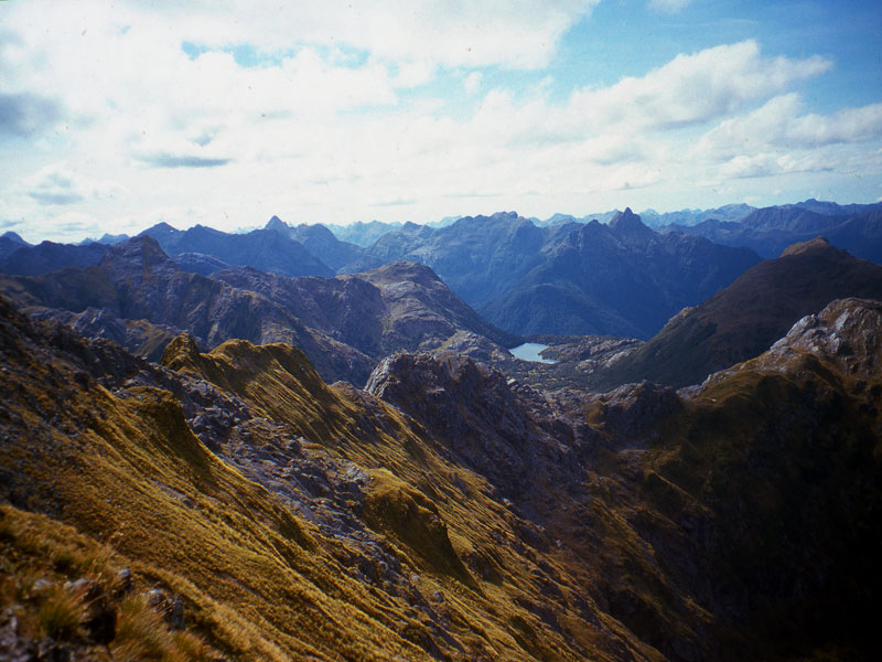
On leaving the hut at Upper Spey more quality Dusky mud was encountered for the first ½ km. However, soon the track climbed steeply up the Warren Burn, then it leveled out for 2 km and climbed gently up to the treeline. When it emerged into a large bowl the pass could be seen. To get over Centre Pass involved another 200-meter climb. The view from the top down the west side is spectacular with Gair Loch nestling deep in the valley below and peaks stretching off to the west. I heard some keas on the way up, but did not see any.

04. Day 2. Looking west from Centre Pass
The descent down to Kintail was initially gentle and allowed me to enjoy the spectacular surroundings in great weather. Soon I reached the treeline and the track got steeper and yet steeper. Due to the dry weather the steepest bits were not too slippery. My left knee did feel the pressure partly due to the 25 kg rucksack I was carrying. In two places knotted ropes were placed which helped with these 3-meter sections.

05. Day 2 Looking Back up to Centre Pass form Kintail
Eventually this steep descent ceased when I reached a 3-wire bridge over a deep river ravine. In another ½ hour I came to another 3-wire bridge over the calm and brown Seaforth River. All the peat in the soil, which has leached into the water, causes this brown staining. The hut was just 5 minutes from this bridge. I was the only person at the hut.
DAY 3. KINTAIL HUT TO LOCH MAREE HUT. 6 hours.
The weather was again superb. I set off quite late at 1100hrs assuming it would be a short day. However, it was very slow going round the north side of Gair Loch due to numerous windfalls and occasional mud. It was classic Dusky terrain. However as a consolation for the difficult terrain I saw numerous blue duck on Gair Loch, at least 4 pairs, and managed to get some photos of them. Indeed the going was so slow it took me nearly 3 hours to get to Kenneth Burn. Part of the problem was my rucksack was so unwieldy it was difficult to get through some of the windfalls.
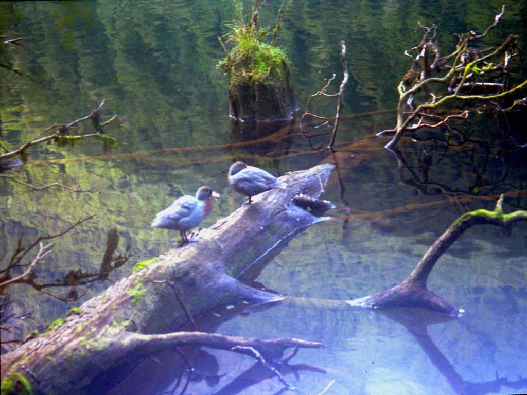
06. Day 3. Blue Duck on Gair Loch
After Kenneth Burn the going was much easier as it followed flats and the levees of the Seaforth River. This area flooded badly in heavy rain but there was no sign of that now. After Deadwood Creek the river crossed some sandy/gravel areas and I left the track and followed these because the track undulated across spurs and was dense with tree roots. I made good time but had to wade across the river a couple of times. Just before the hut I was wading up to my navel when the gravel turned to soft silt. Wary of getting stuck in the silt I had to backtrack 300m upstream and locate the track again.
On arriving at the hut I went immediately to the walk-wire over the river 5 minutes from the hut on the Lake Roe track and washed clothes and myself by swimming in my tramping clothes. The hut was full with 12 of us in it.

08. Day 3. Stumps in Loch Maree. The stump height is a good indication of the water levels to found in the Seaforth Valley and if they are barely showing it will be flooded
DAY 4. LOCH MAREE HUT TO SUPPER COVE HUT. 6 ½ hours.
I left Loch Maree hut at 0900hrs but after 20 minutes realised I had left my water bottle. It took only ½ that time to return. The stumps in Loch Maree were 6 foot high so there would be no problems with flooded areas of the track lower down. The stumps can be used as a gauge of flooding in the lower Seaforth River. If they are covered flooding is likely. There looked very little chance of that changing today, as it was another fine day. At the end of the Loch the track climbed steeply and descended steeply again to avoid a bluff, possibly caused by the slip, which dammed the river.
There are abandoned tools near this bluff left in 1903 when workers gave up trying to cut a track from Supper Cove to Manapouri. The track is still obvious from the end of this bluff to Supper Cove and still has a ditch beside it. It has been washed out in a few places. The track is largely level and after the last 3 days is a joy to walk on. I made good time and even missed the confluence of the Seaforth with Roa Stream, which I wanted to investigate, as I would be going up this stream tomorrow. I passed 4 Kiwi trampers returning from Supper Cove.

09. Day 4. The Seaforth River below Loch Maree
The flood plain beside the Seaforth River had some leviathan red beech growing on it. I saw one with a 3-meter diameter, but it was in decline. There were a lot of mosses and epiphytes in this area and an abundance of tree ferns in the undergrowth. There were many birds here especially the New Zealand Pigeon. There were also a few deep channels across the track and I was grateful these were not full of water, as they would be when the Seaforth was in flood, as the only way across was to swim.
Suddenly the forest cleared and there was a view across a lagoon at the head of Supper Cove. From here the going was much slower with many walk-wires and copious mud. The tide was going out so I left the track and cut across the sand flats at the end of the lagoon. I made good time but could not quite reach the hut due to a deep channel. Not wanting to swim I headed into the bush and picked up the track again for the last ½ km where the going was much slower due to steep undulations.

10. Day 4. Looking down the upper arm of Dusky Sound from Supper Cove
I was again the only person at the hut. I managed to find a hook and line in the hut and dressing in fleece, gloves, sunhat and head mesh, to combat sandflies, went down to the rocks below the hut to fish. I caught 2 spotties using mussels as bait. I nearly caught a large blue cod but it wriggled of as I was landing it. I fried the spotties in the hut. The protein will be needed over the next week.
DAY 5. SUPPER COVE HUT TO NORTH HEATH MOUNTAINS CAMP. 11 ½ hours.
I had to have an early start as I had noticed that low tide was at 0630 hrs. I left the hut at 0730 hrs with all the promise of it being yet another fine day. With the tide right out I managed to walk on sand or mud flats to almost the remains on the old hut. I also made rapid progress along the floodplain past the huge red beeches up to the swamp on the north of the track near the Roa Stream confluence. I decided to carry on for another ½ km then crashed through some pepperwood thickets to reach the Seaforth, which was easily crossed here.

11. Day 5. Crossing Point of the Seaforth River to the north of Roa Steam to gain the south bank
From the river I climbed quite steeply through mixed beech and tree fern forest for 2½ hours to reach a plateau on the ridge. From here I thought I would follow the spur. However, animal tracks were very sparse and the bush got denser and was catching on everything. I had to haul my way over many impenetrable thickets. My progress was now down to 300m/hour. After a further 2½ hours I managed to get to a small knoll at 640m. I continued for another hour to reach a knoll at 712m just 400m away. All in all the last 6 hours had been gruelling. I had climbed only 700m and gone 2½ km. It was a brutal introduction to the bush.

12. Day 5. Heading up the North Ridge of the Heath Mountains to the east of Roas Stream with the Seaforth Valley below
I avoided a steep section by sidling to the south of it initially through subalpine scrub but eventually managed to link up open patches. It was such a relief to be out of the bush. I continued up the ridge passing a stunning beautiful subalpine section with numerous small tarns dotted about in. The ridge here got a bit steeper during the final hour as I made my way up, but now out of the bush progress was normal again. By 1900 hrs I arrived at a small plateau just to the west of peak 1185m, beside a tiny stream. The weather was very clear and still so I decided to risk camping up here.

13. Day 5. Looking Down to the Tarns between knolls 712 and 796 on the North Ridge of the Heath Mountains from Campsite
From my camp I would have easy access to the main ridge of the Heath Mountains. I found out though, that climbing 800m in bush is bloody hard work, which I had underestimated. It was good to finally lie down in the tent.
DAY 6. NORTH HEATH MOUNTAINS CAMP TO LAKE HAY CAMP. 10 ½ hours.
It was yet another clear morning with just a few clouds at the fiords’ entrances to the Tasman Sea. I left at 0830 hrs and sidled the mountain to gain a saddle on the main ridge. Walking along the ridge was very pleasant with stunning views and an easy terrain for 3 hours until I reached peak 1348m.

14. Day 6. Looking down the North Ridge of the Heath Mountains from top at 1348
From here there was a large saddle before Kathryn Peak, which looked steep but feasible. However, by the time I reached the saddle, Kathryn Peak had changed character and looked much steeper. My legs were also very tired so I decided to sidle the mountain on the west side. I continued up to the base of the peak itself then cut down a steep valley towards 2 small lakes. In retrospect I should have gone straight down to the 2 small lakes from the main saddle.
I had a good view across to the main saddle between Roa Stream and the Long Burn, which would have been yesterday’s destination if the weather had been bad. This broad saddle contained a large lake and a number of smaller tarns in a subalpine parkland setting. It was the most idyllic spot I had seen yet. I am sure though, the bush up Roa Stream would have been as challenging as that which I encountered yesterday.

18. Day 6. Treeline to the west of Kathryn Peak
I dropped down to just above the treeline on the west of Kathryn Peak. I thought is would be simple to sidle (traverse) the mountain at this level. However, I found that the streams had eroded about 5 deep gorges down the mountainside and these were awkward to cross. The gorges looked liked they petered out below the treeline but after yesterdays efforts I preferred ravines to subalpine scrub. The last gorge, which descended down from the saddle between Sea View Peak and the knoll 1206m, was a bastard. I might have been able to cross it at 750-800 metres, but was not at the 900 meters I was at. I did not want to lose height so went up and it was not until I was almost at the saddle itself at 1150m that I was able to cross.

19. Day 6. The numerous steep erosion gullies on the west side of Seaview peak were difficult to cross
From the saddle it was an easy descent down into the valley to the west of Lake Hay. I did not go all the way down but stopped at the tree line. From here I could survey the south side of the valley and plan a route for tomorrow’s climb up to a pass marked 1010m on the map.
DAY 7. LAKE HAY CAMP TO NORTH CAMERON MOUNTAINS CAMP. 7 ½ hours.
I had a late start due to lethargy but eventually left the campsite at 0845. The weather was still fine but a bit overcast. I followed the stream down through some heavier thickets until it met the main river in the valley floor. On the way up the south side of the valley I should have followed a line 200-300 meters to the east of the stream coming down from the south to gain the flats and miss the steeper waterfall section. Instead I was too far east, headed south and was soon embroiled in dense bush. To get out I headed higher and soon had to force my way through thick subalpine scrub. It was slow hard work and 3 hours after leaving camp I eventually broke out and looked down onto the grassy flats at the top of the waterfall and open glades leading up to the pass. I now had a ½ hour sidle above the scrubline to reach the pass. Had I followed my intended route I would have reached the pass from my camp in 2½ hours instead 3½.

20. Day 7. Looking back north to Seaview Peak and my camp Near Lake 842 from Pass 1010
From the pass at 1010m I had a great view down to the top of the Princess Burn and over to Cone Peak. I also saw a gentle sloping ledge leading up to the next pass at 1002m, 2 km to the south. It was a very pleasant walk to this pass involving a gentle descent and then an easy climb in very tranquil settings. Once there I had another small climb to the southwest for a km to gain a saddle in the ridge at 1039m. By now the wind had increased significantly and the skies had darkened but there was still no rain.
At the pass, the valley I was to go down tomorrow stretched out before me. It was heavily forested. The descent down to the head of the valley was quite steep in places. I stopped to admire the view halfway down and a very brazen kea joined me. As I got to the valley floor some of the clearings in the subalpine forest looked very inviting campsites. I was quite tired after this mornings bushwhacking and the previous two days exertions, so despite the early hour of 1600 decided to camp in one of these clearings. The wind and grey skies receded in the evening and blue skies appeared again. As I lay in my sleeping bag I was apprehensive about the bushwhacking tomorrow and was dubious if I could get to Lake Kakapo.
DAY 8. NORTH CAMERON MOUNTAINS CAMP TO LAKE KAKAPO CAMP. 9 ½ hours.
The skies were slightly overcast when I made my late start at 0930. It was difficult to find any consistent deer tracks and those that existed seemed to cross and re-cross the river regularly. I still had some good spells when a track existed for up to 200m. Eventually the valley sides levelled out and the riverbanks flattened out. It was much easier to walk in these conditions through the fern undergrowth. After a pleasant spell in the bush the river course itself became flat with gravel banks and it was very easy to follow. When I eventually arrived at the lake marked on the map I found that it had gone, and the river just disappeared into muddy holes between boulders. Obviously there was not enough volume in the river to sustain the level and it flowed into the boulder field quicker than flowing into the lake. It had taken 4 hours to cover the 4 km to the lake.

22. Day 7. View SW from pass 1039m down the valley with the dry lake to the jungle covered giant boulders at the valleys end
From this lake I headed south by southwest in the direction of another small lake 1 km away in the main valley. I was soon in a boulderfield but carried on. Eventually I was in horrendous terrain. Large boulders, bigger than houses, were jumbled haphazardly. There was enough matter on and between the boulders to support large trees, but not enough to fill up gaping chasms between the boulders some 15 to 20 feet deep. The whole area was then covered in thick moss and fallen trees, which were generally in the latter stages of rotting, but looked solid when covered in the moss. I don’t think it would have been possible to devise a more unpleasant place to traverse if one tried. It was also a dangerous place and I can only compare it to a green version of a heavily crevassed area on a glacier. There were no animal tracks here; no deer worth its salt would venture into such an area. In all it took 1½ hours to go 400m. I think it would have been better to go west by southwest in retrospect as these boulders probably came from a slip to the east from the mountain 991m. It took another relatively easy ½ hour to reach the other lake, which was also dry. The lazy river in the lakebed was richly populated with paradise ducks.
It was now 1530 and I had little hope of reaching Lake Kakapo by evening. I decided I would carry on and try to find a campsite in the forest. Initially I followed the river upstream wading where necessary. But soon found the terrace beside the river easy going with occasional good deer tracks. Within 2 hours I seemed to be at the highest point of the saddle. While crossing this flat broad saddle I found a reasonable deer trail for 1½ km on the north side of the valley floor – about 200 meters from the lowest point.
Once the descent started the deer trail seemed to move over to the south side of the valley. It soon became quite distinct and started to climb gently. I guessed that it was the deer forming a trail to bypass the waterfall, which I could now hear. This deer trail then started to descend down to the river, which it reached below the waterfall. This was the first time that I found a deer trail and trusted it even when it started to go up, and I had been rewarded by avoiding the waterfall. When I reached the river it was almost dark but as luck would have it there was a suitable flat dry area to camp on. There was the odd spot of rain during the night but nothing to affect the very low river levels.
DAY 9. LAKE KAKAPO CAMP TO KAKAPO-RICHARD SADDLE CAMP. 8½ hours.
I set off at 0915 under overcast skies. The bush was wet from overnight drizzle and my legs and feet were soaking by the time I reached the forks of the Kakapo Burn in an hour. I found a strong deer trail on the true left (north) of the river and leading away from it. I guessed that this deer trail would lead me away from the boulderfield I had read about in Moirs Guide South. It did lead me away – I would be spared the horrors of yesterday’s boulderfield. God bless the deer. The trail was about 200 to 300 meters to the north of the river. It crossed two small slips but was easy to pick up again on the other side. As the gradient slackened off and the boulderfield was left behind the trail fragmented and I was soon bushwhacking through easy ferns again.
The gradient soon levelled off and the river became lazy. The vegetation also changed from large beech and fern to dense thickets of pepperwood. The river was initially good to follow but soon the gravel banks were replaced by silt. I was entering a swamp. I tied to head towards the south side of the valley, where the slopes lead up to the Kakapo-Richard Saddle, in an attempt to find firmer ground. I found the side but it was bluffed in most places and covered in impenetrable vegetation elsewhere. There was no alternative to the swamp for this area. I dragged myself through the thickets frequently up to my waist in stinking silt. Progress was very slow and in one hour I only managed about 300m. However, I was now past the bluffs and decided to give the side another go. The side was now much easier but steep. I climbed 50 meters and soon was in easy beech forest with fern undergrowth. This was a much better alternative to the swamp so traversed the hillside until I got near the stream coming down from the south.

23. Day 9. Looking down on Lake Kakapo after climbing the dense ridge up to the crescent lake, 755m
I passed a small stream in which I washed myself fully clothed. The silt took some effort to remove but I was eventually cleanish again. As I approached the sound of the larger stream I started heading up to reach the spur on the west of the stream. Moirs Guide South mentioned a good deer trail but I could not find one, despite traversing the spur frequently. It would have been superfluous anyway, as the beech/fern combination was quite easy to get through. After 2 hours I had climbed 400 meters, but soon the vegetation began to get more scrub like and progress slowed considerably. I now had to force and heave my way through thick subalpine vegetation on steep terrain. In one hour I climbed just 100 meters over 300meters distance. At last clumps of snowgrass started to appear on the forest floor and the first longed for clearing arrived. Soon I was able to link up clearings.
After 2 days bushwhacking the clearings were like a Shangri-La. It was a delight and relief to break free of the bush. The clearings became bigger and bigger and before long I was in an alpine idyll of grassy openings and mountain lakes. I wondered through these lakes looking for a campsite in the high parkland. I found one just below the outlet of the crescent shaped lake on the Kakapo-Richard Saddle in a large meadow. This campsite would give me easy access to a pass over to the Lake Mouat Valley. From this pass there was easy access to the main ridge of the Cameron Mountains, which I had intended to follow south.

24. Day 9. Looking south from the crescent shaped lake, 755 on the Richard-Kakapo saddle with Peak 1288 in the distance
DAY 10. KAKAPO-RICHARD SADDLE TO LAKE MONK-LAKE 611M SADDLE CAMP. 10½ hours.

25. Day 10. Looking Back to the Campsite at the end of the crescent-shaped lake (755m) from Height 1135
The weather had reverted back to the blue skies that I was beginning to take for granted. I was anxious that these next two days were good as there were some steep and challenging mountains to traverse and I needed the snowgrass to be dry. I made it to the pass on the Richard-Mouat Saddle with minimal bushwhacking across the parkland. From the pass I got a great view of my intended route down the Eastern Cameron Mountains to Solitary Mountain. This gentle peak rose above the forest-fringed Lake Mouat, which was, stretched out in the valley below. However, the mountain between Lakes Monk and Mouat looked like it might be problematic from this viewpoint, but that would be tomorrows issue.

26. Day 10. Looking south down the Mouat Valley from hill 956 at the north end of the Rugged Mount in the Cameron Mountains
At the pass a ridge rose to the southwest culminating in Peak 1299m. I climbed the ridge in awe of the surrounding scenery. To the north peaks stretched to the jagged horizon. To the west Lake Widgeon marked the end of the Long Burn and its meeting with the sea, with the Dark Cloud Range beyond. I got up to Peak 1288m quite easily along the ridge, but the Peak 1299m looked steep. I had read it was best to traverse it on the east side. Indeed the traverse proved to be quite easy. I kept high up where there was a meter wide terrace at the bottom of the cliffs and above the snow grass.

28. Day 10. Peak 1299 (left) and 1288 (Right) from the Mouat-Richard Saddle
I continued to the saddle 991m and decided to drop down to the alpine Lake 811m. Here I had a drink and pause in the sun. So far the day had been perfect. I felt liberated after being in the bush for the last 2 days. After the rest stop I climbed a shallow saddle to the south and dropped down to Lake 611m. This was one of the most beautiful I had seen yet in a land of beautiful lakes. It was surrounded by meadows and parkland and had a grass avenue leading to its head. I managed to skirt its north side along the shoreline, only occasionally getting my boots wet. I think this was only possible because of the recent dry spell. The sandflies along the shore were out in force though. At the outflow I scoured a route to take me up to a plateau 100 meters above the lake where I intended to camp.

35. Day 10. Lake 661 from the saddle 890 between lakes 811 and 611m
The route up to this plateau was covered in thick subalpine scrub. Before entering the scrub I knew that it would be a problem and I was soon in the worst scrub I had come across yet. It was as dense as coastal wind-pruned scrub and I was often going over it rather than through it. I was doing about 3 horizontal meters a minute. Luckily it was a short distance and within ½ hour had broken out onto the grassy plateau, where I camped. It had been a marvellous day with an overdose of beauty.

36. Day 11. Looking North to my campsite at the Tarn (bottom left) and over Lake 611 with Rugged Mount on the left and the harp peak 1299 on the right.
DAY 11. LAKE MONK-LAKE 611M SADDLE CAMP TO RIDGE ABOVE LAKE MOUAT CAMP. 6 hours.
Having seen this mountain the previous day and from the topographic map I knew that this mountain would be the crux of the whole trip. I needed good weather, – and it was. I started at 0900 and braced myself for the bushbash, but it was not as bad as I had feared. I kept well to the west of the scrub in the more mature beech and then sidled east to reach grassy slopes above the scrub. I was soon up at the saddle and then scrambled up to a subsidiary top. From this top the view was exciting. For the first time I saw Lake Hakapoua, a shiny grey reflection in the sun at the end of the lush Big River Valley. It was in the distance, but significant, because at the far end was the south coast and the end of this wilderness. I also saw the arete over to the highest peak of the mountain, Peak 1203m. It looked tricky.

37. Day 11. Looking south from Peak 1174 to peak 1203 on the right. Beyond is Big Valley, Lake Hakapoua, The South Coast and even Solander Island
I set off and found my apprehension was unjustified, as it was really quite straightforward. I made a small cairn at the top. The view from the top of 1203 north along my route was also stunning and it was all laid out before me.

39. Day 11. Looking North from Peak 1203 along the ridge to 1174. The pointed mountain centre right is Peak 1299 of yesterday
I continued south down an arete to another nearby and slightly lower top. I expected there to be difficulties after this top, and on peering over the edge realised that there was no way down from it. I had to backtrack and then drop down and sidle the mountain on the east side. The descent down the east side was steep and I was glad the snowgrass was dry. I carefully arrived at the small tear shaped tarn and found that I could indeed traverse the east side from here and get back onto the ridge again. The sidle up to the ridge was steep but without problems. Once I was on the ridge again I could look north to Peak 1203m and see that route I had taken down to the tear shaped tarn was the only option.

40. Day 11. Looking north to Peak 1203 whose south ridge was too steep to descent so I had to go to the right
It was a steep, and in some places an airy, scramble up to the final top on the ridge marked as 1098m. I had expected there to be more problems on the descent from here, and after 300m of easy descent thought that I was in the clear. However, suddenly there was a 30m drop. Beside this drop was a steep gully on the east side but it proved to be loose, muddy and slippery, so after just 10m descending I scrambled sideways out of it and back onto the ridge again. Here I down climbed the remaining, and easier, 20 meters on the arete itself. Again I was glad it was a dry day. It was then a very gentle descent down to grassy meadows, little tarns and scattered alpine scrub. From these meadows I looked down to Lake Mouat on the east side, while on the west a waterfall poured out of Lake Monk.
It was only 1500 hrs but I suddenly felt drained. My tank was empty and my legs felt like lead. It might just have been the release of worry about the traverse. I decided I would stay here, on this parched meadow with its mud-cracked dried-up tarns, for the night and appreciate the lofty perch above the 2 heavily forested, lake-filled valleys below.

42. Day 11. Looking NW from my campsite near knoll 911 across the Mouat valley to Peak 1266 on the other side near the head of Lake Mouat
DAY 12. RIDGE ABOVE LAKE MOUAT CAMP TO SOUTH OF PEAK 1121M CAMP. 8½ hours.
It drizzled during the night, but had cleared up by morning, although it was overcast. The vegetation was wet however, so I was soon drenched from my shorts down after descending the steep, wet, slippery grass slope to the saddle just south of the knoll 911m. From here the route followed the arete southwards. The climb up to knoll 916m was not too bad and I came across a deer track, which as expected, went right up the spur through older beech forest. After knoll 916m, however, the vegetation became more scrublike, the deer track disappeared and progress slowed down. I had to keep on the arete here as the sides were very steep. There is much more vegetation on this arete than indicated on the map. Indeed I found this to be the rule of thumb throughout the whole trip.

43. Day 12. Looking south past the saddle 785 and up the NW ridge of Solitary Peak in the mist. To the right is Big River and Lake Hakapoua
By midday I finished traversing the scrub covered arete and made the easy climb up to Solitary Peak, 1180m where I had another great view north of the mornings traverse I had just completed.

46. Day 12. Looking North from the north ridge of Solitary peak towards saddle 785 with peak 1203 unfortunately obscured by mist in the middle
Damp air had started to blow in from the south and the higher tops on my route began to acquire erratic mist patches. From Solitary Peak the going south was very easy indeed and I flew along the even ridge. As I approached Peak 1229m the mist got much more determined and I had to be careful that I descended down the right ridge from this peak. It was an easy drop down to a saddle and up to the next mountain, Peak 1144m. This was shrouded in thick mist. I was very tentative on the descent as it was steep and visibility was only 20 meters. Eventually, out of the gloom the small tarn appeared but it had taken 1 hour to make the descent down 150 meters. It was now drizzling also. I considered camping here but there was no suitable campsites and it looked very exposed and eerie.
At 1600 hrs I decided to carry on a find a camp spot after the next mountain, Peak 1121m. It was a quick simple climb up to the top and making good progress in the thick mist started down the ridge optimistically. After I had descended 150 vertical meters the ridge became very steep. I looked at the map realised that I was coming down the south east ridge rather than the south ridge. In my haste I had not checked the map and had assumed there was only one ridge. I decided to continue down and spotted some campsites in the meadows below as the mist thinned. I eventually had to swing into the bowl formed by the two mentioned ridges and continued down. As I arrived at the meadows the drizzle got heavier and the mist became very thick. It was quite fortunate it thinned for the ½ hour on my descent. As I was looking for a campsite a yellowhead appeared and rattled out a song before vanishing into the still fog. I set up the tent by 1830 hrs and retired into the humid interior. I decided that if it were like this in the morning I would have a day off.

48. Day 13. Looking North from Peak 1076 towards Peak 1203. I came down the east ridge (right) and camped in the meadow below. The high mountain in the background is Peak 1229.
DAY 13. SOUTH OF PEAK 1121M CAMP TO MOUNT AITKEN CAMP. 8½ hours.
I expected to open up the condensation-covered flysheet and see thick mist. I was surprised to see blue skies. It was a late start nonetheless; I didn’t get away until 0930 hrs. It only took an hour to get back onto the ridge and up to the first mountain, Peak 1076 m. Ahead of me however I had nearly a kilometre of scrub covered arete to negotiate to reach Peak 1032. It was steep on the north side and vertical on the south side. It wasn’t long before I reached it and was soon having to haul myself over the tangle of branches. It was very thick and almost impossible to negotiate so I dropped down on the north side and sidled a line about 30 meters below the crest. The scrub was not as dense here but it still took me 1½ hours to force myself along the arete. It was always such a relief and joy to get to the first clearings after a bushwhack.

49. Day 13. Looking SE towards 1032 from near 1076. At 1032 the route heads off to the south (right) down to Mt Aitkin
It didn’t take long to get up to Peak 1050m, and from here the terrain was great. The ridge was covered in short grass and the gradients were gentle. I made fast progress with delightful views down to meadows and parkland on each side of the ridge. It only took about 1½ hours before I was making my way up the slopes of Mt Aitken. I was keen to pass this milestone in my journey, as it was all downhill from here to the south coast. On my way up the mountain the mist started to come in again, so instead of summiting I traversed across the west side and found the southwest ridge without difficulty.

53. Day 13. A view of Mt Aitkin from 1135 some 2 km to the north of it.
The descent down the southwest ridge was very easy, and I eagerly made for a knoll where the forest started. Sea haar was blowing up all the valleys from the sea to the south leaving just the ridges exposed. I didn’t take long to reach the treeline and I was delighted to find that there was no scrub at all, just very mature well spaced mountain beech growing out of a grassy floor. A short distance into the forest there was a small clearing which was an ideal campsite. Water was sparse and I had to take some from a stagnant tarn and boil it before using it. I still had a fair bit of gas in my second container. There was a stunning sunset that evening with the sea haar below and crimson clouds above.

54. Day 13. Looking SW from my ridgeline campsite south of Mount Aitkin over the cloud filled Lake Hakapoua valley
DAY 14. MOUNT AITKEN CAMP TO WAITUTU HUT. 11½ hours.
It started to drizzle in the night and by the morning it was quite windy also. The weather would be largely irrelevant today, as I would just be in the forest descending down to the South Coast Track. Once I reached this track I would follow it eastwards until I got to the Waitutu hut. I was quite excited about reaching this hut. I wondered if there would be anyone there. I hadn’t seen anyone since Day 3; – 11 days ago. Indeed since leaving Supper Cove I had not seen or heard anything that would convince me I was not the sole inhabitant of this planet. It would also be nice to dry boots and socks which had been wet for 2 weeks now.
Initially the descent down through the forest was marvellous with the mountain beech growing out of a beautiful lawn. I noticed the occasional small marker from the NZ Forest Service on some of the trees. This was obviously a rarely used route for fieldworkers. I started following these markers but soon realised that they were leading me down a spur to Lake Marshall. I did not want to go this way so cut back onto the main ridge which headed south. To my horror I found that this main ridge was losing the easy beech forest and becoming covered in scrub. Looking at the map I saw that this could persist for over one km. This could take up to 3 hours. I pondered the markers from the NZ Forest Service and thought they maybe know something I don’t. I would cost me at least ½ hour to retrace my steps and pick up these markers again but looking at the scrub ahead filled me with foreboding. Within ½ hour I was following the markers down the spur again. The ensuing descent was steep and unpleasant. There was one 40-meter section where it was very steep indeed, almost vertical. Eventually it levelled out and still following the stream arrived at the north end of Lake Innes after a further ½ hour.

55. Day 14. On the East shore of Lake Innes looking south to the outlet where the River Aan starts to flow.
It was not a good start to the day. I had dithered at the scrub and this had basically meant I ended up at the north end instead of south end of Lake Innes. I am that sure that if I had persisted I could have forced through the scrub and found the rest of the ridge easy enough down to the south end of Lake Innes. I now had to bushwhack down the east side of the Lake to reach the outlet. It was actually easier than I thought and I reached the end of the lake within 1½ hours.
Following the Aan River was also easier than I thought. There were a couple of waist deep swamps to wade through, and I had to cross, or wade down, the river many times but the forest floor vegetation was not too thick. The biggest obstacle to fluent progress was the large number of windfalls. Because of the convoluted meanders of the river course I did not follow it but was often following a compass bearing well away from the river. A compass was very necessary here, as the ground was flat and there were no landmarks to be seen. The continuing drizzle meant the sun could not be used as a navigation aid either. The dominant beech forest, here mainly red beech, was now becoming interspersed with massive spiral rimu trees. New Zealand pigeons were abundant and there were many fantails, some of them were black, which I hadn’t seen before. Four hours after leaving Lake Innes I knew I was approaching the South Coast Track. My heart quickened with the excitement of seeing a beaten path and orange markers. When I finally got to the track I was delighted. I knew I would make it without having to switch on the Emergency Locator Beacon to get rescued, which would have been embarrassing.
I still had 8 km to go and only about 1½ hours of daylight left and an unsatisfactory LED headtorch. I charged off at pace to Grant Burn as I had been doing all day. It was so much quicker to walk on a track even if it was overgrow and seldom used. Most of the track to Grant Burn followed a long abandoned telegraph line and was through a manuka forest. There were a couple of smaller rivers to ford but this was no problem after some of the swamps I had waded through in the last 2 weeks.
After Grant Burn the daylight finally dwindled at 1930hrs. I stumbled on for another 1½ hours in the dark to try and reach the Hut. I pulled a large muscle in my right thigh, which was painful, and lost my way 4 or 5 times. I could have put up the wet tent and got into my damp sleeping bag but I wanted to get to the hut. In one confused, undulating section I lost the track for 20 minutes. I nearly camped but estimated I was less than a km from the hut. After much peering I found the track again and eventually stumbled towards the hut at 2100 hrs. I was totally knackered, but felt elated. I had made it.
There was an older Dutch couple at the hut who were very surprised to see anyone, especially arriving 1½ hours after darkness. They had the stove on and made me a hot coffee. It was the first hot drink I had had for 2 weeks. I hung up all my damp and wet possessions to dry and then enjoyed the comfort of the fire, my pasta meal and conversation. I went to bed totally delighted. I am sure I had the glint of victory in my eyes. Tomorrow I would sort out some of my stuff and clean what I could.
DAY 15. WAITUTU HUT TO WAIRAURAHIRI HUT. 5½ hours.
I had a small lie in, but the bright sun invited me out of my slumbers and I began to clean clothes and equipment, and then hang them up in the hot sun. The stove was still going so I burnt any superfluous and damaged clothing, the sleeping mat, a tarpaulin, twine and gaiters and all the plastic food wrappings of the last 11 days. I reduced the weight of my rucksack by about 2 kg and greatly reduced the volume.
By 1200 hrs my clothes were dry and I had tidied up and was ready to move on to Wairaurahiri Hut. The muscle in my right thigh was better and I was feeling strong again. I bade farewell to the Dutch couple and set off. The track initially crossed the large Waitutu River on a walkwire before entering the forest again. The track was quite uneventful passing through beech/rimu forests with fern undergrowth. The birds were out in force and there were many fantails, tomtits, and very melodic bellbirds. The only thing that really divided up the track was the 2 walkwires over the Angus and Crombie Burns. There weren’t any views of the sea, which I had hoped for. It was a pleasant walk but nothing to set it on fire. It was a bit of an anticlimax I suppose when compared to the previous fortnight.

56. Day 15.The Waitutu River is a large river draining Lake Poteriteri. There is a wire footbridge across it and the Waitutu cabin is beside this bridge
It was good to get to the hut, as my legs were still tired from yesterday. There was no one else at this hut which was beautifully sited next to the large Wairaurahiri River.

57. Day 15. The Wairaurahiri Hut lies on the east side of the Wairaurahiri River on the South Coast Track
DAY 16. WAIRAURAHIRI HUT TO PORT CRAIG HUT. 4½ hours.
I left the hut at 0900 hrs in patchy sunlight. The vegetation was wet though after the night’s drizzle. The track climbed up 2 terraces to get out of the river valley and into the regenerating forest. This forest was 100 years old, the original one having been logged. Indeed the track followed the old tramline used to extract the timber. The metal tracks had been removed but the original sleepers remained, sometimes under a couple of inches of mud. This abandoned tramline was fantastic to walk along and before I knew it I was at the historic viaduct over the Francis Burn. This viaduct was used by the tramline to span the deep ravine of the stream.

58. Day 16. The historic and preserved Percy Burn Viaduct lies half way between Wairaurahiri Hut and Port Craig Hut
In ½ hour I reached another viaduct and ½ hour later arrived at the Percy Burn viaduct, the biggest of the 4. It was very impressive. It was about 100m long and 35 m high. I stopped here to admire it and have lunch in the adjacent hut while a rain shower passed over. Once the rain stopped I carried on to Port Craig Hut. The track still followed the abandoned tramline and was very easy to walk along.

59. Day 16. For the last 2 days the South Coast track was easy to follow
About ½ hour before the Port Craig Hut I met Westie. It turned out that Westie was one of Southland’s outdoor characters. He knew the area I had walked through and indeed had spent 9 years living in a hut he made himself where Lake Hakapoua flows into the sea at Big River. During this time he lived on his outdoor wits and became something of a celebrity hunter and hermit. He now, at the age of 67, was a possum trapper selling the fur to mix to with merino wool for spinning into high quality wool products. He said he would return to the hut within hour after checking his traps.
The hut at Port Craig was an old schoolhouse. When the tramline existed large quantities of timber were brought to Port Craig for milling. Many people used to work here, and then suddenly in the late 1920s the whole place was abandoned and dismantled overnight. The forest has now claimed back this long gone village. All that remains is the old schoolhouse, which is now a hut. Westie returned after I had unpacked and we chatted. On finding out I had just run out of food he made me a huge steak stew with boiled potatoes. In the evening we were joined by Kay, another character, who was the hut warden from the Humpridge track hut nearby.
DAY 17. PORT CRAIG HUT TO BLUECLIFFS CAR PARK. 6 hours.
I left at 1000hrs under overcast skies and could not take the low tide route along the beach as high tide was approaching. This meant walking on a good track through mature beech forest for 2 hours. This track then cut down to join the low tide alternative and continued along the shore for 2 km, crossing two beautiful beaches. These beaches were stunning and made up for the dearth of seascapes over the previous 2 days. The white sand, covered in various shells, went right up to the fringe of the forest.

60. Day 17. About 5 kilometres from the end of my route the trail followed the beach for a few km on the sjhores of theTe Waewae Bay
After I left the second beach I caught up with 2 Americans. They were just finishing the moderately demanding 3-day Humpridge Track. We chatted and then carried on together in the now warm weather. We soon reached Track Burn where a gravel road started. We followed this for a further 2 km and then could go down to the long beach, as the tide was now receding. After an hour on the beach we sadly had to leave it and had to climb up steeply for 100 meters to get on top of the seacliffs. We followed the top of these cliffs along a good track through a warm humid mixed forest for a ½ hour when I suddenly realised we had reach the carpark and then end of the trail. I got a lift back to Tuatapere with Big El, a founder and the manager of the Humpridge Track.
This was the end. I had sweated up numerous passes, struggled through horrendous scrub, waded through stinking swamps up to my naval, been exasperated in a nightmare boulderfield, had wet feet and had hardly seen anyone for 2 weeks, and lived off a very Spartan diet; yet I was sad it was now finished but looked forward to a shower and a few beers.

61. Day 17. The Rarakua Carpark at Blue Cliffs was the the start of the South Coast Track and The Humpridge Track and my finishing point
EQUIPMENT
On a journey of this nature equipment must be robust, durable, and in good order. It is likely to get tested to near destruction. The other over-riding concern is that of weight. Even with the barest of essentials it is likely your rucksack at the start will have 15 kg of food and 10 kg of equipment. 25 kg does not sound a lot on paper but on your back after 8 hours of uphill bushwhacking and you’ll be wondering why on earth you brought that 250 gram, all dancing, Leatherman multi-tool you never use. For example in the hygiene department I only take ½ a toothbrush and ¼ of a tube of toothpaste. Soap should be left behind and if you are even considering taking a towel you have not grasped the importance of weight and should abandon the plans to do the traverse. Items of clothing will be in need of wash from time to time but crossing rivers does much for socks and longjohns!
The rucksack should have robust buckles and straps. These can take a tremendous strain when forcing through thickets and scrub. It should not be too big 75-85 litres should be suffice, but it will be necessary to put clothing, sleeping bag and tent in compression sacks before packing to ensure everything will fit in the rucksack. It is essential to have a tough plastic rucksack liner both to keep the contents dry and light and to provide buoyancy when swimming across rivers or swamps.
A sleeping mat, preferably of cheap light foam, should be in a tough cover if it is strapped to the outside of a rucksack, otherwise the scrub will shred it and bits will be torn off and left in your wake. There are ample soft places to camp and a heavier self-inflating sleeping mat has no advantage.
While down sleeping bags have far superior warmth to weight ratio over synthetic qualofill sleeping bags when dry they are hopeless when wet. If the weather is poorly it can be a real struggle to keep a down sleeping bag dry day after day. It might be better to consider a good qualofill bag that can tolerate –5 degrees Celsius comfortably. A qualofill bag would certainly render a bivvy bag superfluous.
The three qualities a tent should have is that it is lightweight (max 2.5kg), that it is robust and waterproof (including groundsheet}, and that it can take a reasonable wind if forced to camp above the treeline. Condensation will form in any tent if it is raining outside, and is a problem that just has to be lived with.
While multi-fuel stove are all the rage at the moment they can also be fickle to operate. Furthermore while you are on the camping section it may well be necessary to cook in the tent. With a petrol/spirit stove this could both jeopardise the tent fabric and your respiration. A simple gas cylinder stove with 2 times a 250gram cartridge of 70% butane 30%propane mix should suffice for each person for the duration of 22 days. This should only be used to heat porridge in the morning and boil water for the evening meal. Tea and coffee are luxuries that cost too much weight. Two lightweight, non-stick pans (if one can be inverted and stored in the other to provide a protected case for the gas cylinder and burner so much the better) and a lid.
Clothing has to be kept to a minimum. Cotton should be totally avoided, as it will never dry. A polypropylene top for daily wear can be supplemented by a thin fleece top as medium layer and a thick fleece for foul conditions and to change into in the evenings. Polypropylene longjohns worn under nylon shorts will protect the legs against scrub while bushwhacking. A thin fleece pair of trousers is suffice for evening wear. In addition to this a waterproof jacket with a hood and waterproof trousers are essential. Gloves and hat are also essential.
Boots should be sturdy and offer support against twisting ankles. Fabric boots are not suitable and Gore-Tex liners should be avoided. Feet will get wet, probably on the first day, and there is little chance, or point, of drying the inside of the boots again. 2 thin smooth pairs of socks can alternate daily as the first layer and then a thicker pair of wool socks as the main cushioning and warmth layer. These woollen socks will always be wet and are not a joy to put on in the mornings but it is futile to dry them. A further pair of woollen socks should be taken and kept clean and dry for eveningwear. As a luxury a lightweight pair of plastic sandals for the evening are worth the extra weight. Finally a pair of knee length gaiters will protect legs against scraps, keep the majority of water from wet vegetation, mud and twigs out of boots.
Other items to take include spare lighters, insect repellent, a lightweight sunhat with brim, insect proof head mesh to go over sun hat to thwart sandflies. For route finding essential items are a compass and waterproof map case, topographic maps 1:50,000 for entire route, emergency locator beacon, headtorch, photocopied route description i.e. this and relevant pages from Moirs Guide South are all essential items. Other items to strongly consider are a small penknife, minimal first aid kit, ½ litre water bottle with measures, waterproof camera or camera and waterproof case, annual hut pass and extra long boot laces that could have other uses also.
PROVISIONS
22 days provisions are needed to comfortably do the journey. Assuming that you burn on average 5,000 calories a day while tramping that is a whooping 110,000 calories you need to take. Even if you took it in its most concentrated form as butter or olive oil exclusively you will need to take 13 kg. To take this food is not only impractical but also unpleasant. A simpler and feasible diet ingesting 2,500 calories a day will still mean a daily deficit of 2,500 calories a day. This mean that you body will have to supply the remaining 2,500 calories from stored resources.
In total 55,000 calories can be carried in the rucksack divided into 22 packages each of 2500 calories and weighing 700 grams. The remaining 55,000 calories will have to be extracted out of your body mass by a busy liver. Before you start the traverse you had better make sure you have these extra resources which are basically at least 6 kg of body fat.
Hot beverages are a luxury that squanders weight and gas and should be avoided. Water from any small stream coming into the main water course should be OK as long as it has been aerated by tumbling down slopes, and the larger tarns on the ridges should be fine to drink from. If in doubt about your constitution some water purifying tablets should be taken.