February 9, 2022

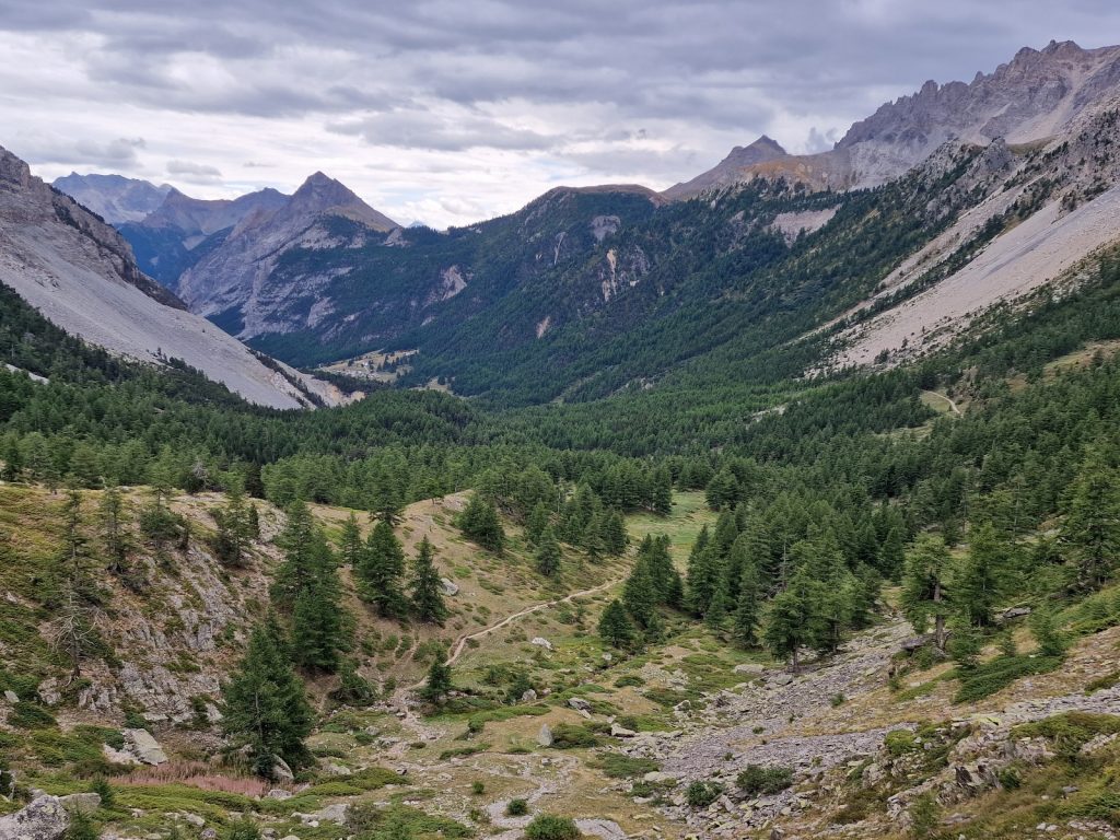
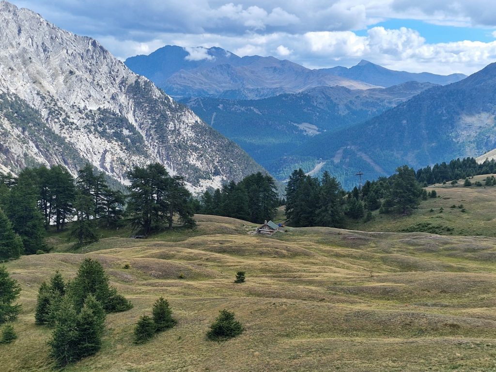
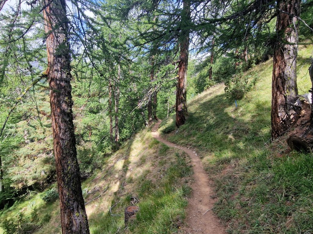
Day 97. Larche to Refuge des Lacs de Vens. 23 Km. 9 Hrs. 1550m up. 880m down.  After two nights and a day off at the peaceful and quiet gite in Larche we were recharged. Our batteries were full, our legs rested and we had relaxed in the sleepy village which was already starting to hibernate. We were now ready to move on to the next section. It was called the Mercantour, or Maritime Alps, and it was the last section and 10 days long with a rest day in the middle. Remy was a day ahead on a slightly different route, Richard and David had vanished, and we were now going a little off piste. There were some other English staying at the gite also but we did not really bond with them. After a good breakfast we got our heavy pack lunches, said goodbye to the two young hosts and set off at 0830. For the second day in a row there was frost on the grass outside the gite but the sky was a perfect blue and the forecast was great for the next few days. The contrails of the higher jets were very short and disappeared quickly so the air at the higher elevations was dry. 

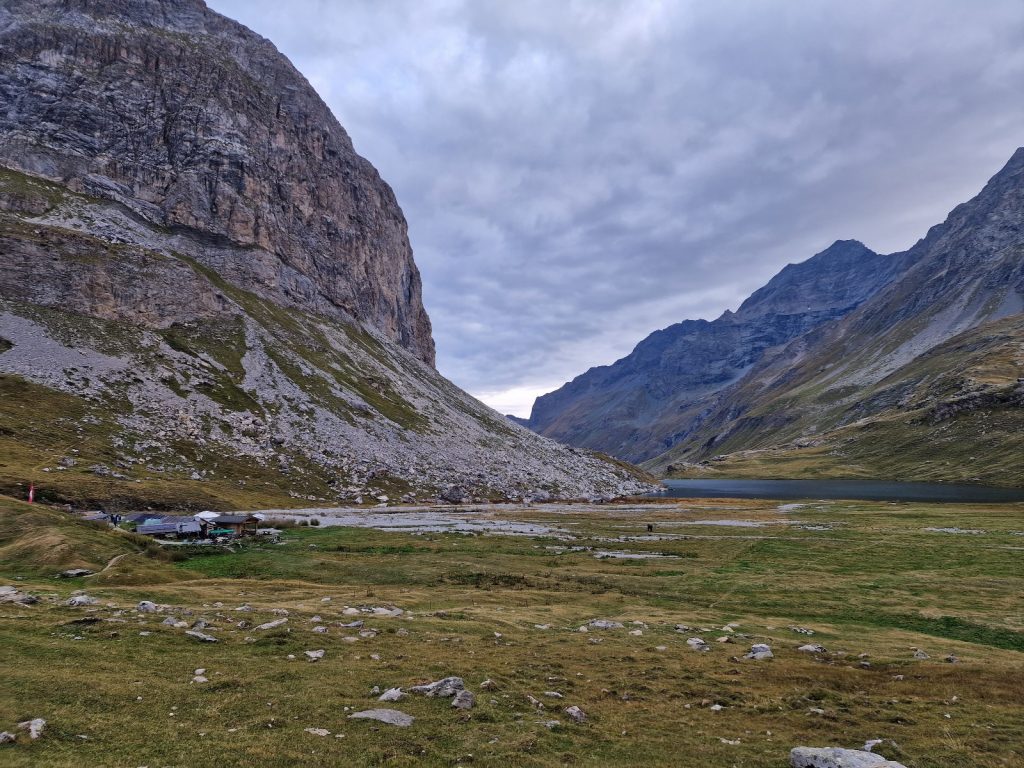
We followed the small road SE up the valley. There was traffic on the bigger road, which went up and over the Col de Larche and down to Italy, but on the small road there was about a car every 10 minutes at the most. It was cold in the forest where the sun did not filter through, but in the glades the sun instantly warmed us. It took us nearly one and a half hours to walk the 5 km to the parking place at the end of the road. The Ubayette stream flowed beside us the whole way, just to the north of the small road and it went to the car park, and then up the valley we were going to follow to the south. 

649.Heading up the Ubayette valley towards the Lac du Lauzanier and the Pas de la Cavale.

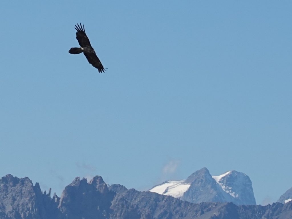
We reached the car park, which was virtually empty and started up the valley so the south where the stream came down. After a few minutes Fiona saw a bearded vulture high up on the hillside to the west. Then I saw another two beside it and soon we were looking at 5 of these huge birds soaring above us. They seldom beat their enormous wings and when they did it was a very slow flap. Their flight looked almost effortless and they circled high looking for carion. One of them crossed the valley heading east and slightly into the wind, but the vulture tucked its wings slightly and sped across the sky sacrificing just a little height. I knew these vultures were rare in the Alps and I had just seen two all trip and here there were five in one place. I think the Mercantour is renowned for its Bearded Vultures but this was exceptional

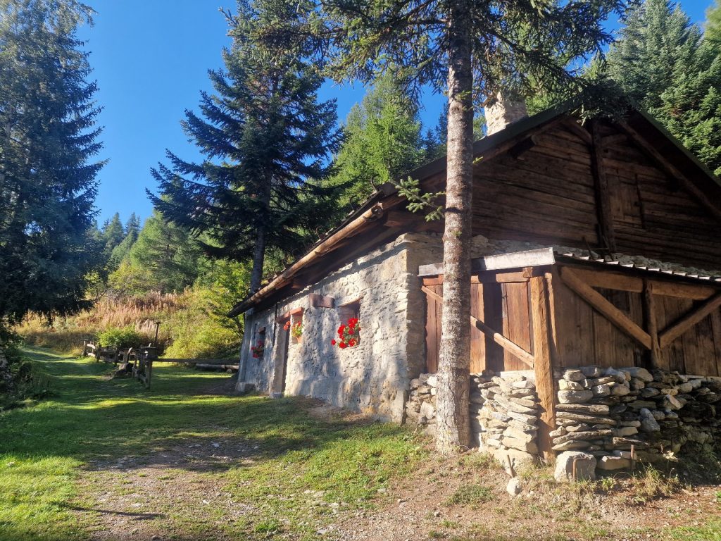
Just a kilometre from the parking place we came across two shepherds chatting beside the small cabin one of them spent the summer in. They were both rugged swarthy older men with a mass of matted hair and crimped beards. They did not look nearly as bright as Seb. I showed them a picture of Seb by way of conversation and they said they did not know him. Just beyond the cabin was a flock of sheep still in their nighttime compound. They were a slightly different breed with brown faces typical of the Mediterranean area. There were 3 large Pyrenean Mountain dogs embedded with them and they were lying on the ground partially asleep. As we continued up the valley there were a few fishermen in the stream fly fishing despite the fact it was in the Mercantour National Park. At the parking place just below where the park started there was a “No Kill” notice for the fisherman but I am sure it was hard to police. 

650. looking south across the lacde Lauzanier up the highest parthg of the Ubayette valley with the Pas de la Cavale out of sight just to the right of the small puff of cloud

After an hour we climbed a small rise and reached the stunning Lac de Lauzanier at about 2300m, and just above the treeline. It was a beautiful lake against a backdrop of bare rocky peaks which were reflected on its slightly rippled surface. We had been going for about 3 hours now so found a small rock to sit on slightly above the lake and had half our picnic lunch here. The lake was perhaps half a kilometre long and 200 metres high and there were about 20 people lying in the grass around it, most I am sure had walked up from the parking place. There were a few fishermen too, casting spinners into the lake from a rocky prominence and I wondered why on earth the park authorities did not ban the habit. After a warm half hour, with the cold of the morning now a distant memory, we continued up. 

651. Some Red Deer, Cervus elaphus, which had been wallowing in the stream just above Lac du Lauzanier.

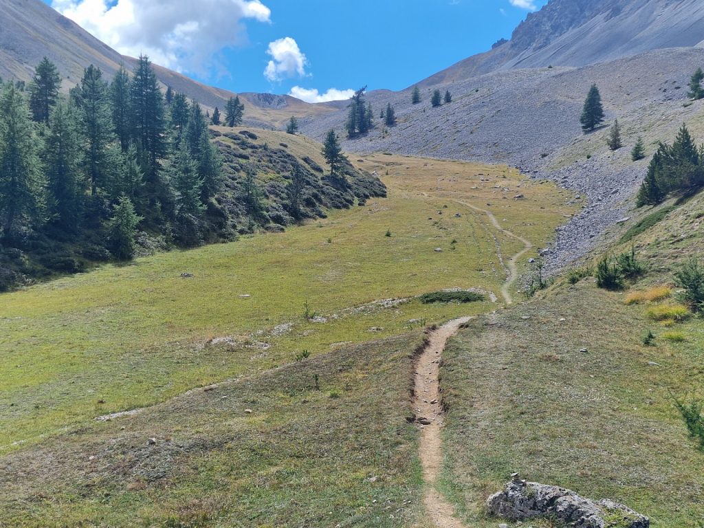
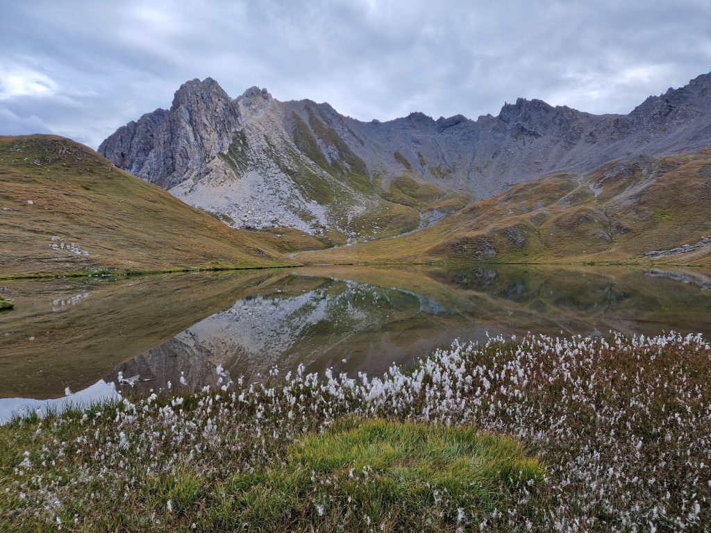
Our path went up the valley, passing a few springs which flowed from the ground and were ice cold after months percolating through the mountain. At one point I saw 5  red deer in the valley wallowing in the deeper parts of the main valley stream far below. They had seen us 300 metres away but were quite confident. I think their fear of man passed down through the generations was beginning to fade now they were not prosecuted in the National Park. We passed another lake, Lac de Derriere la Croix, at about 2400m, which had dried out considerably in this drought and had shrunk to half its size. Just after this lake the path started to climb in earnest up some grassy slopes covered in marmot burrows to reach some screes on the east side of the bowl. The path traversed up these screes on a stoney platform about a metre wide, and was easy to follow until it got to the Pas de la Cavale, about 2700m, our first pass of the day. There was an open view to the south from here over the vast grassy bowl below the pass on the southside, with some small lakes and a couple of shepherds cabins far below. Beyond this bowl was the Tinee Valley and the massif of Mont Mounier, where the GR5 went. However we would leave the GR5 very shortly and go off piste for a few days through the mountains on the border of France and Italy and on the main watershed.

652. Looking SE from the Pas de la Cavale, 2700m, SE towards the Pas de Morgon, 2714m, which is right under the cloud upper centre. Out route went down to the round turquoise Lac d’Agnel, across the Salsa Moreno valley, up to the plateau with the largest Lac de Morgon (just above centre right)) to the Pas de Morgon

The descent down the pass was initially steep as the path made a traverse down a ledge and then double backed on itself to go down under the ledge on steeper ground. It was always safe, especially in the dry, but it was a little loose and covered in gravel and Fiona felt a tad uncomfortable for these 10 minutes. After that the gradient eased and the path dropped down across more scree and then across the upper grass slopes to the small Lacs d’Agnel at about 2350m. These lakes were really depressions in the moraine formed where the glacier of ice and rock melted, dumping the stones in circles as they emerged from the ice. Then the ice left a depression when the it finally melted, which later filled with water. We left the GR5 at these lakes and had our second lunch here after we had been going for well over 5 hours. 

653. Looking NW from the Vallon de la Cabane across the braided Salso Moreno valley to the Pas de la Cavale, 2700m. The path came down the steep sedimentary terraces under the saddle

From the small Lac d’Agnel we headed SE down the cropped smooth grassland for a kilometre at least as we descended into the rocky streambed in the Salso Moreno, which was dry. There was a large flock of sheep below us but were largely stationary and would not reach us. We crossed the dry streambed which was full of rubble from the moraines and bare rocky mountainside above and then climbed the easy grassy slopes of the small side valley called the Vallon de la Cabane. It was a delightful climb up a grassy ramp with serrated mountains on all sides. I thought the faint path would continue west up the grassy slope in the valley to the moraine above, and then ascend this veering to the SE to Pas de Morgon, 2714m, but it did not. Instead it climbed up a small gully to the south to a grassy plateau with the lowest of the Lacs de Morgon. 

654. Looking across one of the 5-7 Lac de Morgon towards the Pas de la Cavale, which is the saddle in the middle. The cliffs we came down look vertical buut this is a foreshortened view and they were not that exposed

For the next hour we had some of the best walking on this trip. The faint path, marked only by cairns, weaved up between small bare outcrops on a rocky turf path. The gong was never difficult and the route finding was easy with the numerous small stone cairns. However what made this ascent really special were the numerous tarns and ponds nestled in the outcrops. There must have been about 6 tarns and 10 ponds in all and they all had a great view across them to the NW and the Pas de la Cavale and the steep descent from it we made just 2-3 hours earlier. Each tarn had its own character but all were very tranquil in the still warm day. They looked very tempting for a swim but I was worried about the time it would take. Each was a deep blue, almost a navy blue, which was probably partially due to a reflection from the perfect skies of the afternoon. Beside one tarn I spotted a larch growing at 2500m which was a record for me on this trip for a conifer. Beside the tarns the blueberry bushes were becoming very autumnal and they glowed crimson if the sun shone on them at a certain angle. After a lovely hour where we climbed some 250 metres we passed the last tarn and then gained the moraine at the top. We followed the moraine up for half an hour climbing another 150 metres to reach the Pas de Morgon 2714m, the highest point of the day. 

655. Looking across the upper 3 Lacs du Morgon at about 2450m with the Pas de la Cavale in the distant right. The lone larch tree is at abouut 2500m

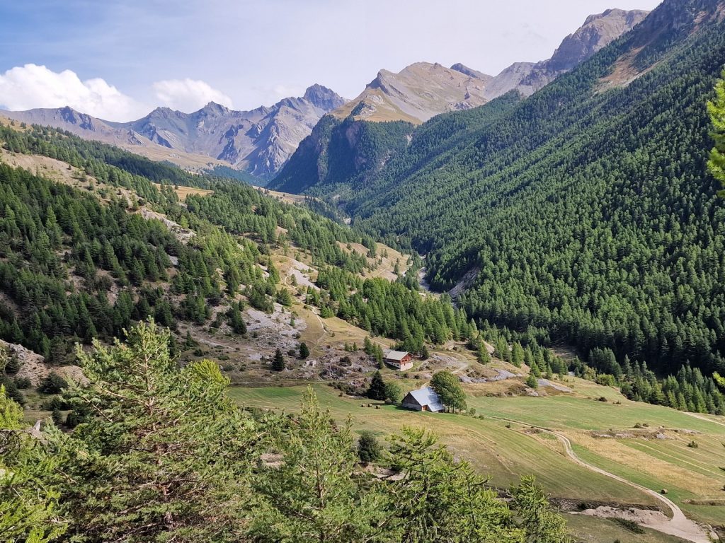
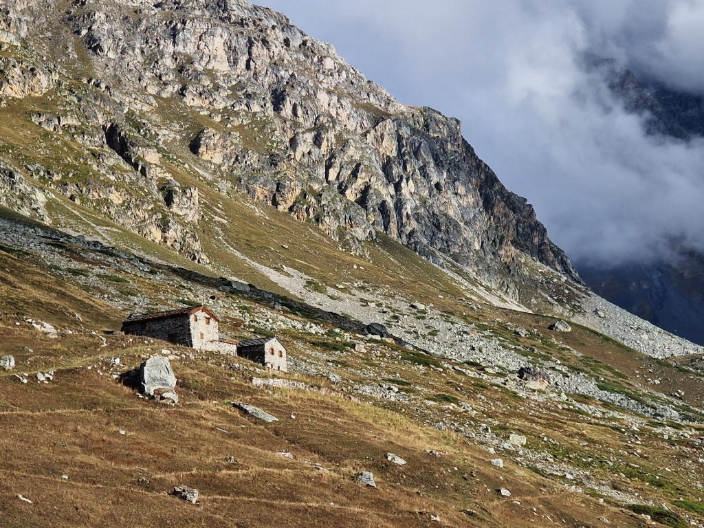
I was a bit worried about what would happen next on the descent down the other side, however it was much easier than I imagined. The faint path veered slightly SE until it got to a prominent ridge which was the Italian/French border. It then followed this ridge for over a kilometre to reach Col du Fer, 2564m. This kilometre was quite slow going as the ground was rocky in places although the rocks were stable and abrasive so our boots stuck to them. Col du Fer I think is a hikers and shepherds thoroughfare as there was a good path coming up from each side. On the French side it was from a stunning high valley, Vallon Tortisse, with a magnificent pasture and a couple of old cabins which were still under a wooden slab roof. On the Italian side the valley leading up to the col looked dry and arid. In the distance we could see the triangular tower of Mont Viso rising above everything as it was the most southerly and isolated 4000m mountain. From Col du Fer the path was virtually level for a kilometre to a small pass called Collet de Tortisse between two modest hills. Here we started the final descent to the Lac de Vens. 

656. Heading along the ridgetop on the France/Italy border between Pas de Morgon, 2714m and the Col du Fer, 2564m unseen just beyond Fiona. Centre left is the Collet de Tortisse pass between two smaller hills.

The descent was not that steep due to an old constructed path which I think might have been some near 100 year old military path. It went down in easy zig-zags, which were so easy we cut across one. There was a unique arch in the beige rock here which looked like it should be in Arizona. Near this arch the view to the south, which was already good, became the double spread of a coffee table book or poster. It  was absolutely stunning as the Lac de Vens appeared below us in a deep bowl at the top of the tree line. The three Vens lakes were laid out in a row at the bottom hemmed in by steep mountains. The colours of the beige rocky mountains covered in crimson blueberry bushes, the dark blue azure waters and the limegreen of the upper larches all under a perfect blue sky were quite mesmerising. It was one of the top three locations of the entire trip. The cabin we were staying at Refuge de Vens was at the head of the largest and uppermost lake on a small knoll with a small stream on each side. It was a perfect and idyllic location. 

657.Descending the easy path from Collet de Tortisse towards the Lac Vens and the Refuge de Vens situated at the hed of the largest of the Lac Vens lakes in prime position.

We reached the cabin at about 1730 and found the host. He looked exhausted after catering for a full house of 40 last night and a weekend of day trippers who had come up for lunch from both Italy and France. However, they had all gone now and there were only 8 of us staying. We had to share a dormitory but it was big and all four couples found a little niche to sleep in. Dinner was large and everyone was full after a couscous terrine and stew and I had a vegetable fry on my couscous. The host was very easy going and aimed to please. Of the 4 couples 2 were German and one of them, Manu and Christof, were very chatty and friendly. We were seated next to them and spent the whole meal chatting enthusiastically. By coincidence all 4 couples were also going to Refuge de Rabuons tomorrow and it was supposed to be stunning also. After dinner I wrote but I had to go well past the 2200 curfew to finish but the host just showed me how to switch off the lights.

Day 98. Refuge des Lacs de Vens to Refuge des Rabuons. 14 Km. 6 Hrs. 620m up. 500m down.  I did not sleep too well in the dormitory despite the fact I was tired and the window was wide open. Fiona for once slept well however. The alarm went off at 0630 for the breakfast at 0700. It was a stunning morning again with just the slightest frost and a near full moon hanging over the lake in the purple glow of the dawn. Breakfast was nothing special but it was large enough for the reasonably short day we were to have. The picnic bags were heavy, always a good sign, and when we inspected them before packing they looked great. I had goodbye to the host, Anton, who was a very competent cook and an all round easy going nice guy. We left just before 0800.

658. Looking down the largest of the Lac Vens lakes from the terrace of the Refuge de Vens with the moon hanging over the lake just after dawn

Initially we went down to the first lake, crossing one of the small streams which cascaded down each side of the cabin. The first lake still had the moon hanging over it as we skirted its northern shore through scattered small larches and blueberry bushes. It was still in the shade. To the south of us and also in the shade were craggy mountains covered in scree and looking very inhospitable. The lake however was very hospitable and gorgeous, and a delightful start to the day. We wandered along its entire shore, occasionally climbing over rounded slabs which sloped down into the lake. Generally the path kept on the turf. As we got to the outflow of the uppermost lake another small one appeared at the end of it, and then after a short steam another larger one appeared again. It was as stunning as the first. At the end of it there was a small cascade where the outflow splashed over a slab and fell into yet another lake. This one was small but there were rings where trout were rising. The path then crossed the outflow to this fourth lake to the south side of the stream, passed yet another tarn and reached the bottom of the first climb of the day. This hour’s riparian wandering was the perfect start to the day. 

659. Looking east up the largest of Lac Vens with the Refuge de Vens sitting on a rocky knoll at the far end between two waterfalls.

The climb was initially steep as it zig-zagged up the hillside glowing in blueberry bushes in the early sun. It had just risen over the rampart of mountains to the east of up which formed the main watershed of the Alps, and the border. The climb was however quite short, just some 250 metres in all and it was over in well under an hour. Near the top was yet another lake, Lac de Babarottes at about 2430m. There were some hardy young larches growing here, well above anything I had seen before and some must have made it to 2500m. This lake was also gorgeous and the sun was shining on its clear waters illuminating a few large trout, perhaps 30cm long, which were cruising along the surface looking for flies. The descent down the other side of this col was initially quite steep and the path was covered in a gravel from the granite type rock, but it was always safe. There was a view down the side valley past a shepherds hut and a compound full of sheep to the Tinee valley. It was around 1000 now and the sheep were still in their compound with the dogs sleeping amongst them. The dogs were easily distinguishable because they were white compared to the brown sheep. The shepherd’s cabin was still in the shade and it might have been the reason he was so late in getting his sheep out to pasture. We descended about 250 metres to an area strewn with moraine above the sheep and then picked up a path we could see contouring across the hillside. 

660. Looking SW from the col after Lac des Barborettes over the shepherds hut in the shade and the night compound for the sheep across the large Tinee valley to the massif between the Tinee and Var rivers

Across the large Tinee valley below was the massif with Mont Mounier where the GR5 went. I could see the small village of Saint Dalmas le Savage on the other side. It was not to be confused with Saint Dalmas, perhaps 40 km further down the valley, where the GR52 split off from the GR5 and headed up into the Mercantour. We would meet the GR52 in 4 days. 

661. Walking south along the sensational Sentier de l’Electric built some 80 years ago to build two small hydroelectic plants under Lac Robuons and Lac Vens. The latter was neverbuilt but the path remains

The path we arrived at which contoured around the mountianside was called the Sentier de l’Electrique. It was the most amazing path as it was well constructed some 70-90 years ago probably by an electricity company. It was completely flat which in this very rugged terrain was quite a feat. We followed it for the best part of 4 kilometres as it contoured around the spurs and veered into the gullies. It was absolutely flat and easy underfoot so we could stride out along it, often two abreast. Occasionally the path narrower to a less than a metre but usually it was well over a metre. Where there were cliffs and buttresses to negotiate the path was supported on stone terraces or hacked into the cliff. It even went through two small tunnels to maintain its level route. Larch trees clung to the steep mountainsides above and below the path which mellowed its appearance. At one stage as we cross the rocky spur, called Crete de Ballai, we could look down into the Tinee valley far below and see the very small town of Saint Etienne de Tinee. After this spur there were the remnants of an aerial tramway with the rusting ruins of a small metal wagon. The metal wagon must have ferried goods between the tramway and the barrack buildings in the next valley we went into a kilometre further on. The barracks were still standing and it seemed some workmen were living in one building as there was a large generator outside. 

Just beyond the barracks were signs saying the Chemin de l’Electric was closed for a section, for everyone’s safety. The signs were dated 2014. It was due to a small tunnel on the pathway which had collapsed and there was no way round. We were spoiled by its lovely flat surface and now looked at the diversion. It climbed 250 steep metres over a spur and then descended to the flat track again just a kilometre from the barracks. It took a good hour to climb and descend the 250 metres over the spur. The tunnel collapse had forced the authorities to make the diversion and there were 4 workmen constructing the diversion. They had already constructed the route up over the spur and were now constructing the route down the other side. We had lunch just after the old barracks built by the electricity company some 80 years ago before the climb. 

662. The very pretty Lac Fer was at the high point of the diversion from the Sentier de l’Electric. It lies in a south facing cirque under Mont Tenibre, 3031m, in the miiddle of the photo.

After lunch we went up the steep hillside on the new well constructed path which zig-zagged up the slope in easy hairpins. It took a very short hour to get to the top and then walk across a high plateau to reach the absolutely stunning Lac Fer. It was nestled in a cirque surrounded by jagged mountains culminating in Mont Tenibre, 3031m. The sun was shining on its surface illuminating it and it was easy to see the large trout swimming on its surface and even a metre down. Around the edge of the lake was a fringe of yellow shallows before it got deeper and its colours changed to mixtures of green and blue. We marvelled at the lake for 10 minutes contemplating a swim but then decided to push on to the Refuge de Rabuons. We descended down the other side of the spur on the path the workmen were still constructing and reached the wide level track made by the electricity company 80 years ago just above the small lake called Lac Petrus. 

663. After the diversion over the srur with Lac Fer on top the route returned to the Sentier de l’Electric path for another 4-5 km passing through a couple of tunnels to reach Refuge de Rabuons

Now we were back on the easy spectacular wide and level path again having bypassed the tunnel collapse. We still had about 5 km to walk and it took us about an hour and a half – partly because we took so many photographs. This second section of the Sentier de l’Electrique was even more spectacular than the first and the challenges of construction even greater. The mountainside was very steep and in places the wide path was hacked into the cliffs and on other occasions it was built up on high terraces. On two more occasions the path could not go round a buttress so it tunnelled through it. The whole time the path felt very safe as it was built to take heavy machinery on metal carts to the small hydroelectric powerstation. Halfway along we came out of a tunnel, rounded a spur and caught sight of the night’s refuge on a rocky ridge which was the natural barrier to create the Lac Rabuons. As we approached it we came to the small power station which had just been modernised. It took water from the lake just the other side of the natural granite barrier via a small tunnel and then put it through a turbine before releasing it back onto the hillside. The electricity company which built the track here from the workers barracks also built the one we walked on before lunch to take water out of the bottom of Lac Vens but never got around to it before the National Park was created. From the small powerstation to the Refuge de Rabuons the wide easy constructed path ceased and it was replaced by a more traditional rocky footpath for the 10 minute walk. Just before the cabin the view over Lac Rabuons appeared. Unfortunately the lake was hydro regulated and the level was low so it lay at the bottom of an ugly bare ring of rock which despite the dramatic mountains as a backdrop made it unsightly. It was just outside the National Park. 

The cabin was quiet when we arrived and the host, Charlie, greeted us and showed us the dormitory and told us to take any bed. There were two others already there so we took beds near the end wall hoping Manu and Christof would take the beds near the door and keep it open. However as the afternoon wore on, more and more people arrived including a large bunch of teenages on an outdoor education trip. By the time supper arrived it was crammed and it would be a noisy night. I wrote the blog before supper as everyone was arriving, while Fiona had a shower in an outdoor cubicle where a long black hose snaking across the hillside for a few hundred metres supplied warm water on this hot sunny day. The host, Charlie, came over and explained the options for tomorrow. The path I originally intended was no problem, he said but it was long. He suggested an alternative with a 200 metre scrambling section on the ascent over the pass to the west of Lac Colle Longue. He said the descent on the east side was easy but I thought Fiona would be uncomfortable on the scrambling ascent so we would revert back to our original route which was 3 hours and perhaps 600 metres of ascent longer. Charlie said he could give us an early breakfast at 0530 and I snapped at the chance. I had finished writing an hour before dinner at 1900.

Day 99. Refuge des Rabuons to Sanctuary di Saint Anna. 29 Km. 10.5 Hrs. 1640m up. 2110m down. I did not sleep that well again. I made sure the window was open when I went to bed, but someone must have closed it in the night and the temperature in the dormitory just got hotter and hotter. When the alarm went off at 0530 I did not feel that refreshed.  We took everything downstairs to pack into our rustly bags and then had breakfast. It was a poor breakfast of pale light breads and weak coffee. The only redeeming ingredient was catering muesli and powdered milk which we heaped into our bowls like a condemned man. By 0615 we were ready to go but it was not quite light enough and we had to wait another 10 minutes before we set off for fear of tripping over a boulder.

664. Lac Rabuons in the the very early morning from the ascent to the south up over the west spur of Tete de Jassine.

I had been a bit worried about the path we were to take as it was not marked on any map I had seen. However, it was marked on various online charts and the host, Charlie, had explained it was recently improved. When we started I was astounded that it was so good. It was negligent of the map makers to leave it off both the official ING map and the Didier Richard Edition map I had, which was not really worth the paper it was printed on. We skirted the south side of Lac Rabuons and then started to climb up the path which had been cleared in the scree on the west ridge of the rocky triangle of Tete de Jassine, 2914m, mountain. As we climbed the sun came up on the peaks across the Tinee Valley below and the brightest stars in the sky started to fade. It looked like it was going to be a beautiful day as per the forecast. We flushed a covey of some 5 ptarmigan whose wings were already turning white. They flew down the path and we passed them again some 10 metres away. They were just too well camouflaged to photograph in the late dawn light. Some 20 minutes later we saw a large male European Mouflon, Ovis aries musimon. The Mouflon is the feral descendant of a primitive sheep which was reintroduced to the Alps. It was the first and only one I had seen on the whole trip. It was very wary of us and took off across the scree long before we got close with an intuitive fear of humans which Ibex do not seem to have. There was a short steeper section just to get up onto the main ridge. 

665. A European Mouflon, Ovis aries musimon, running down the scree on the west spur coming down from Tete de Jassine. it was 200 metres away

Once on the ridge we could see the path descend gently into the wild cirque with Lac Clapiere, a small alpine tarn, nestled in the scree fields just below the head of the valley. The descent down into the valley was easy on a gentle path which was occasionally strewn with boulders but previously someone had removed the most awkward ones and tried to level the route off. The path went along the floor of the valley contouring out again to the spur on the south side. As we walked along I saw three Bearded Vultures come over the ridge by Tete de Jassine, glide over our valley and disappear over the spur where we were going. The vultures seemed to be on a mission rather than aimlessly soaring. 

666. The sun just about to rise over the Main Alpine Divide to the east of Lac Clapiere, which can just be seen above the path mid photo.

We crossed another high valley descending slightly as the good path continued to contour round from the two spurs which enclosed it. There was a small clear stream tumbling down it and this enabled a flock of sheep to thrive in the bowl. As we circled round above them they were still in their night time enclosure. When we rounded the spur on the south of this second high side valley yet another one appeared. It also looked quite pastoral but we could not see any sheep in it. On the farside was a gentle rounded ridge with a small knoll peppered with small hardy larches at the upper limit of the tree line. The knoll was called Tete Gorpa. When we got to it an hour later after another easy descending traverse across the bowl of the day’s third side valley, it revealed a small tarn in a tiny hidden shangri-la covered in grasses with a few protective copses of larch trees. It would have been a great place to camp.

667. Heading south round the middle of the three side valleys which the path virtually contoured round between the west spur of Tete de Jassine and the knoll of Tete Gerpa. Amazingly this path was not marked on the official maps

After Tete Gerpa the path now climbed for a good hour and a half. Initially it was easy across the grassy hillside covered in brown grasses but as we ascended it went into a small steep sided bowl with a steep exit on a looser path where small floods had brought gravel and stones down in heavy rainstorms. In one place it washed the path away but it was still easy to cross the tiny ravine. Once we climbed up out of the bowl we sauntered across the scree covered hillside on what looked like a constructed rough track. The track was probably a very old military track linking all sorts of ruined stone houses. The track delivered us to Col de Colle Longue, the end of our second climb for the day at 2533m. There were some views here over to the Mont Mounier massif across the large Tinee valley to the SW and we had had these views all morning. However we could now see north over the col down the deep steep sided valley to the north and to the village of San Bernolfo. To our east was the very craggy mountain of Tete de l’Autaret with a path going up it. Just below the col on the north side was the Lac de Colle Longue and we dropped down the very stone rough track to it. 

At this circular lake we had a choice of routes. The first route, very adventurous in its nature, headed off to the east over 4 passes to the Sanctuary at Saint Anna. It was about 10 km and involved some 600 metres of ascent. The last two passes were not really passes at such as the path traversed the hillside from one saddle to the next. However the first two were more challenging with the second, Passo del Bue, 2603m, being of an alpine nature with an exposed section. It was likely that this route was also across rocky ground of boulders and scree which would have been slow. It was all a bit of an unknown route on which I could find little information. The other option was perhaps 16 kilometres with over a 1100m of ascent, so much longer. However this second route choice was on easier and well frequented paths which would have been faster to walk on. It was less adventurous but at least it was assured we would not have to turn back if the going got too difficult, as might be the case with the first option. Fiona was keen to do the easier longer option so reluctantly I agreed. 

We set off down the valley towards the small Lago di San Bernolfo which we could see at the bottom. The route down followed a rough military track which had been carved through the scree fields. It was quite easy underfoot and just a quick glance to the side at the scree showed us how difficult it might have been in the large boulders without this track. As the track descended the terrain became more hospitable and soon there was turf beside the track meaning we could cut across the dozens of hairpin bends the track took. On each side the valley walls became very steep and rocky. Looking up the side valleys I could imagine the scree fields we might have encountered had we gone the other way over Passo di Bue. Soon the valley became very pastoral and we came to the meadows around the Lago di San Bernolfo where there were cows of a very light, almost white breed, grazing. Just after the lake we went over a very small saddle, passed the closed Rifugio de Alexandris Foches, and entered the forest. It took a good half hour zig-zagging down the track in the forest to reach the small village of San Bernolfo, just on the other side of the bridge. We had been going for 6 and a half hours now and heard there was a small cafe here so made the slight detour to visit it. 

668. Looking SW back up to Col the Colle Longue after the long descent on the old military track which took us down to Lago di San Bernolfo in Italy

The cafe was actually a refuge called Rifugio Dahu de Sabarnui and it was a delightful place in an enchanting old wooden building with a worldly well travelled crew running the place. Inside it was decorated with lots of historic or quirky items which made it look like a rednecks hang out in the rural MidWest of America, but it was anything but and was quite Bohemian and artistic. We had a cake each to make up for the poor picnic which Charlie at Refuge de Rabuons provided, and were ready to do the last half of today at 1400 hrs. We wandered back through the pretty village in the middle of its steep harvested hay meadows, recrossed the bridge over the small stream in a deep slot and entered the fir forests again. 

669. Approaching Passo Sometta, 2209m, at the head of the smaller Vallon della Sauma, whhere we met a herd of Piiedmontese cattle

The route now went up the Vallone della Sauma. The track initially went up through the firs on zig-zags until it quickly became impassable for vehicles and reverted to a path. The firs were large and the forest floor was covered in blueberry bushes and mushrooms. The mushrooms were largely of the Amanita genus and were either inedible or poisonous. They were not glutinous at all but very dry and shrivelling and cracking on the stalk in this drought. After a good hour the forest started to thin and by now it was largely larches. There was a path up the rocky valley side which led up to the Laguna della Sauma but we needed the path which went straight on up this now pastoral valley to Passo Sometta, 2209m. As we approached the path I came across a small herd of the white cows again which I now had discovered were of the Piedmontese breed. 

670.Looking south from Passo Somatta towards the Main alpine Divide and the border. The mountain is Roche du Saboule. The path from Passo del Bue to Passo Tesina goes along the bottom of the scree slopes about the sparsely forested outcrop.

At the Passo Sometta we could look over the small alpine valley to the south to the main alpine watershed and the mountains on the French Italian border just a kilometre south. I could see a small path traversing across the scree between saddles. The path came from the Passo del Bue to the west and the descent looked easy from there. This would have been the route we would have taken earlier had the ascent to the Passo del Bue not been so exposed. We had had to drop down the 100 or so metres into this small alpine valley into the upper larches again and follow its crystal clear small stream down for an easy half kilometre to its junction with the Vallon di Tesina valley. It was a remote and wild spot and there were plenty of marmot at the junction of the small high valleys. I drank from the stream and the water was immensely refreshing.

671. Looking from the small hidden Shhangri la at the head of the Vallon di Tesina to the Passo Tesina 2400m in the middle of the ridge. The path goes up from the left under Cima di Tesina, 2460m, which is the rocky summit.

We were getting tired now but there was still another 400 metres to climb up to the Passo Tesina, 2400m. As we climbed through the larches again I could look back down the Vallon di Tesina and see that just below the point where we joined it was a shepherd’s hut and a large area of dark bare earth where the flock spent the night. It must have been a big herd of 2000 animals. The path to the Passo Tesina climbed up a shallow escarpment to a higher valley of pastures and small ponds. It was quite idyllic and a bit of a hidden paradise up here. However the whole time we could see the final ascent up the pass and it looked quite long. It was not as bad as it looked in reality and the crimson blueberry bushes, spectacular views and the occasional stand of very old Arolla pine eased the slog.

672. The final 200 metres or so up to Passo Tesina was on a soliid path with autumnal blueberry bushes and scattered Arollo pines beside the path.

With tired legs we found the descent was on an old military track and the gradients were quite gentle. It was just what we needed and we followed the track down, losing a couple of hundred metres until half an hour later we reached a small tarn in the grassy plateau just before reaching Lago di Saint-Anna. On looking at the map I saw the Sanctuary di Saint Anna was just below us and we could cut across the grassland, off piste, and get there in 500 metres, rather than follow the path for a couple of kilometres. We headed off cross country and followed the water supply down. It was perhaps not the easiest route as there was a screefied to cross with large stones and then rocky turf, some of it quite steep and wearing on our tired legs. However soon the roofs of the Sanctuary appeared just below us and 5 minutes later we had gone through another herd of Piedmontese cattle and were in the upper car park at our destination. 

673. On the ill advised, off piste, rocky descent which was a short cut from Lago di Saint Anna to the Scantuary di Saint Anna, whose roofs can been seen below

The Sanctuary di Saint Anna was a high monastery, the highest in Europe, at 2030m. It had a large Refugio attached to it with comfortable rooms and a number of more monastic buildings with simple rooms for the more pious. There was a large chapel, the beating heart of the whole complex and a cafe and small gift shop. We had booked into the Rifugio Alpino Casa San Gioachino and were shown a room on the first floor with an attached bathroom. There was an extended clothes washing session in the shower before dinner at 1930. Dinner was simple and a bit disappointing with small portions. Probably a great size for worship and prayer but way too small for a hard hike. We were sat next to two people doing the Via Alpina. She was a Swiss 40 year old and he was a German 50 year old. They were both doing the trip independently but had met up and hiked together. They were the type of hikers all other hikers tend to avoid as they were so competitive and factual. I felt they were hiking the Via Alpina for all the wrong reasons. We mentioned nothing of our trip and they continued to become unbearably superior. He said he was going to hike the 500km Kungsleden next and did I know anything about it. I told him to google my books on Amazon which surprisingly he did. He was a bit quieter afterwards but the Swiss Miss carried on lecturing us about her brilliant tent choice and how our tent was flawed. We could not get away quickly enough. It was an early night and we slept like logs in the dark, quiet room with no disturbance.  


Day 100. Sanctuary di Saint Anna to Rifugio Emilio Questo. 20 Km. 7 Hrs. 1180m up. 830m down. We had a day’s rest at Saint Anna. I had put it aside to write the blog and explore the chapel and its environs. It was a coincidence that our rest day was one of the wettest days of the entire trip. We felt quite smug to be sitting in the large warm building with the rain pouring down outside. We only went out once and that was to the cafe at midday. They did great panini, mozzarella and tomato sandwiches and we had 2 each. They were so good we ordered another 12 to have as our three meals when we were at Refugio Emilio Questo tomorrow. That refuge was closed but we could use the winter room as shelter but there would be no food hence the 6 large paninis each. Fiona went to have a look at the chapel and we managed to buy some batteries and soap in the gift shop. which mostly sold religious icons. I managed to catch up with the blog before dinner by which time the rain was just petering out. Dinner again was a disappointment. The main course for vegetarians was just a few slabs of cheese. I made my feelings known to the waiter and told her it was just lazy.  During the night the rain returned and there was a tremendous thunderstorm with lightning very close by. I was pleased to hear it as it would bring an end to the constant rain and drizzle and clear the skies.

674. Looking back to Saint Anna Sanctuary. The Passo Tesina, 2400m which we came over to get to the Sanctuary is just out of the picture on the left

I got my revenge for the poor supper at breakfast and was quite brazen in helping myself to three times my entitlement. I was like a hungry dog. We got our picnic from the sanctuary, paid our very reasonable bill, said our goodbyes and went down to the cafe beside the large chapel. The guy at the cafe we chatted to yesterday had our 12 panini sandwiches ready and packed, which was great. We paid for them and managed to stuff them into the tops of our rucksacks without too much crushing. We finally left the whole Saint Anna complex at about 0900 under a beautiful clear sky. 

675. Heading SE down the gente Crete de la Lausetta at around 2300 metres rowards the Col de la Lombarde, which can just be seen slightly right of centre

Our route climbed immediately, firstly up the road heading south for half kilometre or so until it petered out. We then continued south up a track for another half kilometre until it changed into a path. The path continued to climb, sometimes quite steeply up the northern ridge of the shallow Cima Moravachere, 2383m. Once we gained its rounded summit the path headed south west for the next 4 km along the crest of the rounded ridge, called Crete de la Lausetta, leading to the Col de la Lombarde. It was a gentle walk through the uppermost scattered larches across the hillside covered in autumnal blueberry bushes, juniper scrub and small willows. On our east side was the Vallon di Sant Anna with the road in it winding up to the Col de La Lombarde and on the west side far below was the Vallon de Chastillon valley in France where the road which went over the col headed down again. It took a couple of hours to reach the Col de La Lombarde, 2351m, from Saint Anna and it was quite busy when we got there with a mix of old men on motorbikes, couples in campervans and sports car drivers. One thing they all had in common was to photograph their various vehicles at the pass. There was also a contingent of road cyclists who were doing this famous col, which was occasionally on the Tour de France or Giro d’Italia itineraries. There was a small kiosk in a van here and he was selling large sandwiches. We had one each as an early lunch.

After the Col de la Lombarde our route went down the road into France for a few hundred metres until it reached a path which veered off to the east across the lower flanks of Cime de la Lombarde mountain. The roughly constructed path went through some tedious scree fields. It was slow going but without the path it would have been very arduous. The path also went through some easier slopes covered in larch woods before alternating back to the angular scree fields. It dropped the whole time as it went round the spur and into the upper Vallon de Chastillon valley. Suddenly there was a modern ski village below us, called Isola 2000. It was a blot on the otherwise wild landscape, but nowhere near in the same category of eyesore as Tignes some two weeks ago. We wandered under ski lifts and walked down pistes and up access roads for nearly an hour until we reached a large artificial pond, called Prise d’Eau, which was used to store water for the snow maker nozzles in the winter. Across the valley to the south there were many pistes which had been cleared in the forest and moraines which had been bulldozed smooth for this industrial tourist complex. However at the round storage pond we could turn our back on it all and head into the craggy mountains again up the small side valley called Vallon de Terre Rouge. 

676. Looking east across the Lac de Terre Rouge, 2452m towards the Baisse du Druos pass 2628m, which is seen in the middle of the skyline. It is the current border wityh Italy although this border has changed over the centuries.

The path up this side valley went first east up through the larches on rocky ground with frequent scree fields and outcrops. The path through them was well constructed and I guess as it was near the border it was done by the military some 100 years ago. A half hour after leaving the artificial pond the path reached a junction under the looming rocky peak of Cima de Tavels. One path went south to Col Merciere while our path went north to the Lacs de Terre Rouge. It only took half an hour to weave up through the outcrops to reach the magnificent and wild cirque with a handful of lakes nestled in it. All around us steep craggy mountains rose up to form a jagged arc some 500m above the lakes. There was a small chink in the ramparts which surrounded the lakes and that was on the border at a pass called Baisse de Drous, 2628m. On the north side of this cirque the rocks and the screes below them were a red colour and it was this which gave the cirque its name of Terre Rouge. The route from the lakes went up across this scree on a small constructed path. It traversed up high above the largest lake which changed colours as the sun and shadows flashed across it. Well above the lake it made a switchback and traversed up to the very jagged rocks of the pass. The path up to the pass was hacked out of the cliffs in some places and built on terraces in others, again probably 100 years ago by the military. At the top there was a great view down the matching cirque on the Italian side which was even wilder than its French counterpart. 

677. The beautiful Lago di Valscura, 2274m is on the east side of the Baisse du Druos pass and in Italy. At the far end of the lake there was a shepherds house and a recently departed flock of sheep who had been here for the summer.

The descent was again on a military track which had fallen into disrepair but was still good for hiking. It descended a couple of hundred metres to a large old barracks which were now derelict and about to collapse. They belonged to the Ist Regiment Alpini of the Italian Army and were from the First World War. The tracks from this conflict have been very useful to us over the last 4 days. From the barracks we descended another couple of hundred metres to the very beautiful Lago di Valscura, 2272m. It was again on the old track which had been destroyed in a few places by small flooding streams. All around this remote Italian cirque were small buildings high up on the mountain sides, where soldiers must have kept watch in cold miserable conditions. When we reached the Lago di Valscura the sun was out and we sat on a terrace and ate our second lunch. This lake also changed its colour frequently with just subtle changes in the sun’s rays. It was very clear and there was a cluster of boulders in the middle which almost formed an island. As we ate we saw crows harry two large birds of prey circling around the cliffs above us. I think they were too small to be a pair of eagles but perhaps they were hawks. The walk to the end of the lake passed more ruined barracks and at the outflow of the lake was a beautiful small meadow. A shepherd had been here with his flock recently and had spent some of the summer in an old building with a new tin roof. He was probably returning to the plains of Piedmont now. 

678. Looking west from the outflow of Lago di Valscura, 2274m towards the pass of Baisse du Druos, 2628m, which is on the jagged skyline in the centre of the photo

It was only 3 km to the Refugio Emilio Questa from this lake but it was the most remarkable and wildest of the day. The route was a mixture of rocky path and an incredible pavement some 3 metres wide through the most inhospitable and challenging boulderfields. It must have also been a military road and I spared a thought for the hundreds of wretched Italian soldiers who must have laboured in harsh conditions to build it. In stretches it was still good and it wove and twisted through huge boulders. Its wide surface was made with the flat edges of thousands of large stones fitted together. It led us up to a remote lake, Lago del Claus, 2344m, in a very deep cirque surrounded by a ring of extremely jagged peaks. The track, something like a rugged version of the yellow brick road from the Wizard of Oz, ended here and a path continued for another half hour to take us to the Rifugio Questa on the edge of the Lago delle Portette, 2361m. The mountains around this refuge really looked as rugged as the Dolomites and although they were under 3000 metres they were incredibly spectacular and jagged with serrated ridges buttressing them up. 

679. A section of the old paved military road between the lakes of Lago di Valscura and Lago del Claus. This road was perhaps 100 years old and built by soldiers. Refugio Emilio Questa is in the cirque just after the dark knoll in the centre right

The Refugio Emilio Questa was also an old barracks of the First Regiment Alpini from the First World War. It was closed and the host, Marco, had emailed me a few months ago to tell me he was closing early as he had run out of water in this prolonged drought. However there was a winter room with no facilities other than a roof, tables, mattresses and blankets and we were welcome to use it without charge. It was quite an ugly stone building and the lake it was beside had shrunk considerably into a steep sided cone and was now 100 metres from the shelter. When we went in we found a middle aged French couple were there. There was space enough for 10 people though. We went to collect some water in the deep, almost unnatural looking depression and then came back to settle in. The French couple were very nice and quite experienced in the mountains here and we could glean some information from them. After our dinner of 2 paninis each and a bar of chocolate for dessert I wrote until 2130 when it was time for bed. I hung the food as I am sure the place would have mice and went up the steep ladder to the mattresses in the attic space where we slept.

680. Passing Lago del Claus, 2433m, en route to Rifugio Emilio Questa which is about half an hour way in the next cirque south

Day 101. Rifugio Emilio Questo to Refuge Cougourde. 19 Km. 9.5 Hrs. 1440m up. 1660m down. During the dark night I could see towns twinkling on the plains. It was difficult to imagine that there were large cities down there where humanity thrived after so long in the mountains. One of the cities was probably Cuneo. When light came we could see down the valley which led to this plain and far below us was the Rifugio Valasco which was once a royal hunting lodge for Vittorio Emanuele II, initially King of Sardinia-Piedmont and who later unified Italy into a Kingdom. It was in this era and the later border conflicts with France when many of the military roads we had been walking on in the last couple of days were built. We had a relaxed breakfast of another of the two baguettes each, which were starting to get a bit soggy after 24 hours.

681. Heading up a section of paved track in Valle Morta towards Colletta del Valesco, 2430m, and the the Fremamorta lakes beyond this col

We eventually left at 0830 which was probably a bit too carefree as today was certainly an unknown quantity with very small poorly marked paths. Initially we went down a rocky track with much of it in the shade. Near the cabin we saw two female chamois, each with one of this year’s kids. The kids were still frolicking even at 5-6 months old. The rough path circled round the head of the valley across scree chutes, dropping into the upper larch forest with big trees. After an hour of this path it reached a side valley which headed up to the SE. There was a path here which came up from Refugio Valesco here and we joined it. It was also a constructed path which in places was quite wide and well made to the extent is was paved with flat stones and 2 metres wide in places. We climbed it as it went up this side valley, called Val Morta, climbing out of the last of the grandee larches onto rocky valley floor. Within an hour we had reached the Colletto del Valesco pass, 2430m, where there was a great view down to the lowest of the 3 Fremamorta lakes, 2359m, and the rugged mountains beyond which were as wild as anything I had seen on the entire trip in this remote corner of the Alps. Beside the middle of the Fremamorta lakes was a small red bivouac hut of the type I have stayed in in the Dolomites with 9 beds. It was called Bivacco Guiglia, 2437m. Looking from the saddle we were on the route down to the first lake, surrounded by a large boulder field, looked like it was the Great Wall of China. We got to the first lake within a few minutes and could see large trout swimming on the surface of its deep azure waters. We had to walk up the well constructed track between the lower and middle Fremamorta Lakes where we found the path which descended some 600m all the way down to the remote Gesso Valley. 

682. The lowest Fremamorta lake, 2359m from the Colletta de Valesco. The track which looks like the great wall of china leads up to the small red Bivacco Jacques Guiglia, on the knoll centre right. Our route went down into the valley on the left  

The descent down to the Gesso Valley was slow as it was very stony and crossed a few boulderfields. Nearly every step had to be considered and we were thankful it was a dry day and the soles of our boots gripped the rocks. There were a few sections of zig-zags between the boulders where the path descended on gravel and steep turf before veering south to cross another strip of rocks. About half way down just at the treeline there was a short cut. We took it and within a few minutes I was hoping we had not made a mistake as it became very rough and steep with the occasional exposed section. However as we went down it the larches got larger and more dense and this made it feel more secure as it traversed the steep hillside in an eroded groove. After half an hour we reached the main path again and continued the descent down to the valley floor. The clunk of cow bells from a herd of some 40 cows echoed up the valley side and it gave the impression that this area was pastoral but it was really far too rugged for cattle except on the valley floor where there were some pastures at Piano della Casa del Re. The high jagged mountains completely surrounded the head of the Gesso valley and there were high grey jagged peaks on all sides, except for the narrow entrance to the north where the track came up. Just before we got to the valley floor there was an exceptionally rocky path, marked only by small cairns across boulders to the base of a spur where there was the small Refugio Regina Elena stone cabin, 1850m. It was newly restored and maintained by the Sezione di Genova Alpine Club. However it had closed after the summer and all its metal shutters were firmly closed. We had lunch in the shade beside it as we had been going for 4 hours now and finished off the last of our now soggy baguettes from the Sant Anna cafe. Although we had been going for 4 hours we had very little to show for it as the terrain forced us to be slow and cautious. 

683. Looking down from the Fremamorta lakes into the Gessa Valley and the meadow of Pian della Casa dei Re, centre right. The gorge and valley of Balle di Balma Guilie goes straight up from this meadow directly away from us to the col with a small peak in the middle of it.

After lunch we started the main climb of the day, which was a 900 metre ascent to the Main Alpine Divide and the French border. Our route initially took us up one of the fan of 4 side valleys which came down to Rifugio Regina Elena at the head of the Gesso Valley.  This side valley was called Vallone Assedras. The climb up it was quite sustained but not too steep as it zig-zagged up through the thinning larch forest to the north of a small clear stream cascading down the V shaped valley. It was an easy half hour climb during which the Refugio Remondino appeared above us, perched on an outcrop. With its tall facade and red shutters it looked like a Tibetan Monastery. However, well before we reached it the path crossed the stream and forked and we had to take the small branch which I was pleased to see was marked by old faint paint marks. 

684. Climbing up the steep gully from Vallone Assedras to gain the top of the buttress which we had to traverse across the top of to reach the Vallone di Balma Ghilié. The main valley below is the Gesso valley and the Colletta de Valesco pass and Fremamorta lakes are at the upper left of the photo.

685. Going south across the top of the buttress between the Vallone Assedras and the Vallone di Balma Ghilié. The Vallone di Balma Ghilie is straigh ahead and the gorge is down the valley to the right

The small path we took climbed up very steep small zig-zags in a narrow gully between two crags. Essentially we had to go up this gully to climb up beside, and then over, the buttress separating the Vallone Assedras side valley we had been climbing and the Vallone di Balma Ghilié side valley which we were now trying to reach. We could not go up the latter valley from the head of the Gesso valley as the route was impassable lower down due to it being in a gorge. Once we had climbed the zig-zags to reach the top of the buttress I expected up to make a steep exposed traverse across the side of the valley to reach its floor above the gorge, However it was a very pleasant easy walk along a balcony path beneath large rock faces and above outcrops which dropped of into the gorge below.  Small streams came cascading down the rock faces and crossed the grassy slope where the path went before plummeting over the crags into the gorge. There were a few outcrops but the faint path threaded a pleasant route through them traversing the valley side and delivered us into the upper V shaped valley above the gorge. The floor of this valley was covered in boulders but there were some grassy slopes which the path tended to follow. It took a good hour to climb up this remote rocky path to reach the saddle on the main ridge which seemed to have 2 names, namely Col du Guilié and Colle est del Mercantour, 2639m. The view south from the pass looking into France was spectacular, but the view to the north down the side valley we had just come up and beyond into Italy was very wild and rugged. We rested in the remote grandeur for a minute or two to get our bearings and work out the next section. It felt like we should be at the highest point of the day but there was still more to go and we could see it looming in front of us 

686. Climbing up the Vallone di Balma Ghilié above the gorge which is unseen below. The buttress we had to traverse over the top of is in the cetre right. The main valley below is the Gesso valley and the Colletta de Valesco pass and Fremamorta lakes are at the upper centre left of the photo.

687. Looking SE from the Col du Guilié / Colle est del Mercantour, 2639m towards the pass of Baisse de Baissette, 2645m, which is seen directly above Fiona. The route up to this pass went up the grass and slab slopes just to the right of the scree. The ascent was not as steep as the photo suggests.

We had to descend for 150 metres on the faint path south into France and then leave the path and follow a non-existant path, marked only by cairns. This non-existent path would take us up rocky slopes climbing another 250 metres to reach the day’s high point of Baisse de Baissette, 2645m. From where we stood it looked quite daunting but as we set off and started the descent and the climb we saw it was not that bad as the initial foreshortened view made us think it was. However it still took well over an hour as the terrain was quite taxing which meant we were slow. At this final pass there were two small tarns, the Lacs du Baissette which were very calm in the windstill late afternoon. Fiona was walking just in front of me at the lake and had her head down as she went round an outcrop so she did not see the enormous ibex until she was just 3 metres from it. It was the largest ibex I had seen and we estimated it was nearly 200kg and with huge curved horns. It was completely debonair and just stared for about a minute as we fumbled for cameras. It then sauntered off without being the least bit concerned. A bit further we met another younger one who was not quite so carefree and snorted when Fiona got too close. It was the closest we had got to ibex on the trip and it lifted our spirits on what had so far been a demanding and arduous day. 

688. The enormous male ibex which Fiona nearly walked into on the Baisse de Baissette, 2645m, pass. We estimated that this ibex was a little under 200 kg and perhaps 14-15 years old.

689. Another ibex on the Baisse de Baissette pass. This ibex was only 7-8 years old and perhaps just over 100 kg. It let out a snort when Fionsa got too close

Just after the ibex and the tarns on the col we reached a lip and beyond it was a steep descent. There was still no path and just a few sporadic cairns here and there to follow, but it was largely off-piste. We were lucky that the descent was not a bit steeper as we could just thread our way down across rough gneiss slabs and grassy slopes between outcrops. I was constantly scouting the route on the way down as it would have been easy to end up in an area which was too steep and we would have to back track. The slope was largely convex so it was difficult to see what was ahead but I did have a GPS route downloaded and followed it as much as I could. As we descended the slope 3 lakes appeared below us in the cirque. The lakes were called the Lacs Bessons. Initially they looked large on the still evening but as we approached them we realised we were quite close to them and the light was playing tricks with our perceptions. The lakes were on the floor of a cirque which was almost bare slab with very little grassy patches between them. Beyond the cirque was the towering gneiss mountain of Caire de l’Agnel, 2937m, one of a handful of lofty mountains on the main alpine watershed and border. As we descended the light changed to a more rosy hue and the rocks in the cirque took on this colour too. We eventually picked our way down to the largest and lowest of the lakes and saw they were just separated by small waterfalls over the bare rock. It was an otherworldly and unique landscape with the bare rocks slabs going straight into the mirror calm surface of the lakes. We crossed the outflow of the main lake, 2541m, and then looked at the map. 

690. The stunningly beautiful Lacs Bessons lakes. These 3 lakes lay in a cirque of bare gniess with the mountain of Caire de l’Agnel, 2937m as a backdrop.

My original plan had been to go over a slight rise and then straight down the steep unseen hillside to the Refuge de Cougourde, 2100m. However our legs were tired and I was worried that the path, which would be poorly marked and invisible to the eye, would be difficult in this rocky terrain and we might get into trouble. With less than 2 hours daylight left I decided to take the more secure path down the Vallon des Lac Bessons valley and then the Vallon Sangue valley. My map was useless but I had some digital apps on my phone and they indicated there was a shortcut path from the Vallon Sangue to the Refuge Cougourde. So confident there was a good path we set off down the first valley which was quite steep and loose, but there was a beaten path from people coming up to view the lakes. At the bottom of this first valley it joined another valley and the terrain eased off and it became quite grassy. As we descended we came across many chamois and a few more ibex. These ibex were again very confident and barely moved as we approached. I got a bit close to one and it snorted and swung its head in my direction as if to warm me. The chamois were a bit more nervous but we could still get within 20 metres of them. As we went down the valley we passed about 20 of them in all, mostly in small groups or individuals. After an hour’s descent, with an hour of daylight remaining, we reached the turnoff where the shortcut should be but there was none to be seen – not even a stone cairn. It was much less than a level kilometre to the refuge across the hillside but perhaps 3 kilometres, and with a lot of elevation, if we stayed on the path down the valley and up another. We decided to go cross country across the hillside.  

691. In the Vallon Sangue below the 3 Lacs Bessons there were many chamois. The chamois were a bit more nervous than the confident ibex.

692. There were also many ibex in the Vallon Sangue below the 3 Lacs Bessons. This ibex was about 20-22 years old and must have weighed over 150kg. It was very confident, but let out a snort and swung its formidable horns when we about 2 metres away.      

This short kilometre took us nearly an hour to traverse. It was largely scrub willow and some areas of large boulders. We slowly picked our way across them trying to link up the grassy areas. It was never steep but the terrain was very difficult and it was slow to walk across. There were a few more chamois here and they wandered about the terrain easily. After half an hour we reached the path coming down from the lakes which I initially planned to take and it was as difficult as the path we were on. Had we come the original way it would have been quicker but not by much, perhaps an hour at the most. Once on this original path we continued to clamber down on the boulders and scrub but with the occasional cairn to give us some assurance. It took another half hour to descend the final half kilometre and reach the refuge by which time the light was beginning to fade at around 1930 hrs. We had been on the go for nearly 11 hours.  

693. On the off piste route across the boulder and scrub covered mountain side between the Vallon Sangue and the Refuge de Cougourde in the last light of the day with the gneiss monolith of Caires de Cougourde, 2921m, on the left of the picture

The hosts were very welcoming and interested in the route we took. It was very seldom anybody walked here from Refugio Emilio Questo. There were just 10 of us staying at the hut and 6 of them had already eaten. We shared a table with the other two who had not eaten and by luck they were vegetarian also. It seemed we were the only hikers here and all the others were climbers who were going to climb Cima Cougourde tomorrow. There were ropes, helmets and climbing racks all over the dining room as the others prepared for their climb. The meal was excellent and there was a lot of it. After nearly 36 hours of soggy baguettes most things would have tasted good, but this meal was a cut above the usual. After dinner the host showed us a room. It was a dormitory with 8 beds in it but we had the whole room to ourselves. Fiona went to bed pretty much immediately but I stayed up to write some notes for the blog and eventually went to bed at 2200. It was a very spectacular day in remote wild mountains with some great wildlife and the stunning Lacs Bessons lakes but the terrain was very difficult and slow. However we had made it and from now we would be on the well marked and used GR52 path for the remaining 4 days to the Mediterranean Sea. 

Day 102. Refuge Cougourde to Refuge de Nice. 11 Km. 6.5 Hrs. 980m up. 910m down. After the long hike yesterday we were both remarkably well refreshed in the morning and got up for the 0700 breakfast. It was large and generous with plenty of heavy brown bread and jam. We set off at 0800 on what we hoped was a reasonably short day as it was only 10-11 km. However as yesterday showed the distance was reasonably meaningless compared to the terrain. There was quite a strong and cold wind. It did not bode well for the 8 climbers who were also staying at the refuge and wanted to climb the stout steep sided gneiss monolith of Cima Cougourde today. We had not walked far from the cabin when I had to stop and dig out my soft shell jacket to put over my shirt and Fiona had to put gloves on. 

694. One of the many chamois we saw in the walk up to Pas des Ladres, 2432m. Thus one was near the side of te beautiful Lac de Trecolpas, 2150m.

695. Looking west back to the Lac de Trecolpas, 2150m, with the Mont Pelago, 2768m, in the background with the sun of it. Refuge de Cougourde is in the valley to the right

The path contoured round the valley side for a little under a kilometre on a good path which linked the refuge to the GR52 a little to the south. It was a lovely start to the day through some old growth larch woods with some very old twisted and contorted large trees, which were much more venerable than most humans. There was a lot of chamois in these woods grazing on the grassy glades amongst the trees. Perhaps the cold wind had driven them down from the higher treeless slopes above. Looking back to the refuge I could see that the route we had originally planned to come down yesterday to the refuge before we changed our plans did not not look difficult at all and in retrospect we should have taken it.  After a short half hour we joined the main GR52 and climbed slightly up the lip of a large open cirque, surrounded by rocky mountains covered in boulder fields. The floor of the cirque had a scattering of larches and a beautiful lake called Lac de Trecolpas, 2150m. There were signs here saying no camping but there were two tents up ignoring the diktat and risking a fine by the park authorities. Neither set of campers looked very experienced with cheap, heavy equipment. There were chamois here also scattered near the lake and in the larch copses. There was a lovely island at the far end of the lake which was connected to the shore by a natural causeway which was exposed in this dry summer and it looked quite idyllic. The whole of this part of the cirque was still in the shade and the bitter wind was cutting through my jacket and as we set off up the slope it seemed to get colder still. It was not until we had climbed up through the boulders on the path to reach the pass some 45 minutes later that the sun reached the lake. However, just on the east side of the Pas des Ladres, 2432m, the sun had been out for a couple of hours and had started to heat the slopes and just out of the wind it was warm again. 

696. Our sunny lunch spot on the shortcut across the pastoral bowl beside the Vesubie stream. After lunch the GR52 path traversed up the scree slopes in the shade to the side high valley and then on to the Pas du Mont Colomb, 2548m, in the photos centre

At the pass there was a fork with one path heading NE across the slope toward Col de Fenestre on the border and alpine watershed. The convoluted Via Alpina long distance walking route came over this pass. However we wanted the other path which went south down the grassy slopes strewn with rocks and boulders for a kilometre to the Refuge la Madone de Fenestre. It was an easy saunter down this path with 2 groups of chamois grazing quietly beside the track in the warm sun. We did not go all the way to the refuge but took a very easy short cut across the grassy valley floor for a few hundred metres to a lush pasture beside the Vesubie stream. The was a small south facing bank of earth here covered in marmot burrows and it was sheltered from the wind. We had lunch here with the marmots continually poking their heads up to see if the coast was clear and they could come out again. These marmots would soon be hibernating. They would retreat into a burrow and form a ball with perhaps as many as 20 marmots cuddled together with the smallest in the middle and the large grandees on the outside. Their body temperature would lower to about 6 degrees only and they would spend about 6 months in this state until the spring snows started to clear and they could emerge next summer. So for their imminent hibernation they needed to put on as much weight as possible to see them through. We only kept them waiting for half an hour before crossing the stream on stepping stones to gain the main GR52 path again, which was just on the other side, to start our second climb of the day. 

697. Half way up the shaded scree slopes was a small crag to scramble up for a few metres. It was not steep but one needed hands to help get get some of the steps.

698. The final slopes up to Pas du Mont Colomb, 2548m, were in a side valley which became clogged with large stones.

This climb went up a vast sloping ramp covered in scree on the north side of the steep mountains of Caire de la Madone and Caire Barel. They rose so steeply from the scree that they blocked the sun and virtually the whole climb was in the shade. The wind had never really eased today and it was back with a cold bite to it as we slowly plodded up across the large stonefields gaining height as we went. There was a small buttress in the middle of the stones which we had to clamber up but it was neither high or exposed. After a cold hour we reached the top of this stony ramp and passed the two mountains which blocked the sun to enter a high side valley. This was also strewn with boulders and stones from a small glacier which had left them here as it melted. However there was a rough path through them and it climbed steeply, sometimes in zig-zags, to the notch in the jagged ridge called Pas du Mont Colomb, 2548m. The pass was quite alpine in nature, especially on the east side which we had to descend. Initially it was very steep for 10-15 metres and we had to clamber down using our hands also. It soon eased off but the terrain was very difficult, with the whole cirque we had to go down covered in stones and boulders. They were stable, having settled over the last 200 years or so since the glacier left them but there was plenty of scope to put a foot wrong and stumble. The descent was only 400 metres in all but it took the best part of an hour to work our way down. Every step had to be considered and carefully placed. There was no worn path here but there were painted marks on the boulders showing the best way to thread a route through them. The valley floor was green, grassy and looked very inviting and it slowly approached as we went down, but just before we reached its sanctuary the route we had to take to Refuge de Nice veered north and we headed away from these meadows.

699. The first 10-15 metres down the east side of Pas du Mont Colomb, 2548m, were very steep and again you needed your hands to clamber down the narrow rocky slot behind Fiona

700. Reaching the bottom of the cautious 400 metre descent down the east side of Pas du Mont Colomb and nearing the inviting meadows at the bottom. Unfortunately the route did not reach them but headed north before we reached them up the valley to the right

Instead we went north up the valley for 5 minutes until we came to a dam. I was surprised to see a reasonably modern concrete dam here as it was clearly inside the Mercantour National Park which I thought would have existed before the dam. But I found out at the refuge that the dam was here before the Park was created in 1979, having been built in 1969. Once we were past the dam and its eyesore was forgotten we entered a very beautiful cirque with dammed Lac de la Fous on the floor of it. This was relatively busy with a few dozen fishermen round the shore. This was in contrast to the corresponding National Park on the Italian side where fishing in the lakes was not allowed. We went round the west side of the lake with the larger refuge sitting on a knoll at the far end. It was a beautiful situation in this wild mountainous bowl where only the lower slopes had any grass at all, and the higher slopes were slabs or bare rock supporting angular peaks. 

701. Looking across Lac de la Fous to Refuge de Nice. In the background are the 3000metre mountains which for the border and the main alpine watershed

I had expected the refuge to be quiet but it was full and all 52 beds were taken. We got 2 beds in a dormitory with 6 beds but this was in an alcove off another dormitory with 16 beds. We spread out our sleeping bags to claim our beds and then went down. It was quiet but in the next 3 hours it filled up and the dining room was rammed. I met the two wardens from Larche gite where we stayed over a week ago who had now finished for the season and were hiking. I also chatted with 4 French Canadians who we had met at Saint Anna 5 days ago. There was a group of Swedish ladies who we chatted to for a while also but the dining room was getting busier and busier especially when 3 families with 6 parents and about 10 kids arrived. Unfortunately they were in our dormitory so I feared for the night. At the meal we were seated next to the four French Canadians. They turned out to be some of the most educated people I had met on the entire trip and they were all scientists. One was a senior microbiologist and another was a climate scientist. The climate scientist was fascinating and very informative and witty. He said you had to remain an optimist in his field to survive as the situation was so serious. He explained that while carbon release was a big problem he said the real issue was the melting permafrost in Canada and Siberia which would release millions of tons of methane which was currently locked up in it. Methane was apparently 25-30 times more harmful than Carbon when it came to a greenhouse effect. We all went to bed early and I must say the 10 kids in our room went to sleep at 2130 and stayed quiet until the morning so my fears were completely unfounded.

Day 103. Refuge de Nice to Refuge de Merveilles. 10 Km. 5.5 Hrs. 610m up. 710m down. I had to get up in the night and open both the windows, one at each end as the temperature in the dormitory was so hot. There was now a cool draft, but no one complained in the morning. Breakfast was very poor and small but the table next to us were all men and they were drinking heavily last night so we suspected they would not be up for a while and their table was still empty. So we raided their bread and butter. They could always ask for more when they surfaced. We continued our enthusiastic chat with the French Canadians over breakfast. One of them, Don, had a nasty cut on his knee after a stubble, so Fiona checked his dressing and resealed it. It was the worst place for a deep gash; horizontal and right in the middle of the kneecap so it opened with each step. We left at 0800 on a frosty but clear morning and yesterday’s wind had moved on so it was calm.

702. The cold Lac Nire, 2350m, with the Pas du Nire on the skyline behind it to the south. Vallon du Mont Chamineye went off to the left out of the picture.

After 5 minutes we came to a small grassy area above the refuge. It was covered in about 15 tents. Some campers were up but I suspect most were waiting for it to warm up a bit before they got out of their cocoons. I reckoned it was still below freezing at -2 to -5 degrees and it would remain in the shade for an hour or so before the sun rose over the high ridge on the east side of the cirque we were about to walk up into. As we walked up the path we saw a few chamois grazing near the path and others sitting on top of small outcrops chewing cud looking at the sparse string of hikers which Refuge de Nice had just discharged. After half an hour we reached the beautiful Lake Lac Nire, 2350m. It was still largely in the shade and quite cold but there was a strip of sun along the north shore and it created some great green and blues shades. The large steep mountains to the south of it probably kept this lake in the shade most of the time, especially in the winter months when it would be frozen over. After the lake the valley, Vallon du Mont Chamineye, levelled off a bit and although it remained predominantly rocky, as was the norm with everywhere in the Mercantour, there was the occasional grassy strip and a few small tarns on the valley floor. An hour after leaving the refuge however this saunter came to the headwall of the valley and we had to climb it for a good hour to reach the pass, Baisse du Basto,2693m. Most of the climb was in the shade and it was cold enough for Fiona to put gloves on.  The last half hour of the climb was across large boulders marked with small paint marks. We once lost the path and by the time we realised we were 100 metres from it. Rather than return to the supposed path as the crow flies we tried to take a cross country route to reach it further up the slope, but the boulders were so large and awkward it was very time consuming and perhaps a little dangerous so we went directly towards it losing height and time. As we reached the Baisse du Basto we burst out of the cold, drab, shade into the bright sun and the whole day became much more pleasant. The French Canadians were already here basking on rocks and having some of their picnics, which the Refuge de Nice had provided.

703. Looking SE from the Baisse du Basto, 2693m, pass across the upper Basto valley to the Baisse de Valmasque, 2549m pass in the middle. The distant mountain is Mont Bego 2876m.

From the pass it was easy to see the next part of the day and it looked lovely with a long descent down a gentle valley with a good smattering of grass and turf among the boulder fields and outcrops and then a short easy climb to a smaller pass called Baisse de Valmasque, 2549m, less than 2 hours away. Beyond this small pass was the fabled Vallee des Merveilles. After a short chat with the others we set off down the fantastic valley. Almost immediately we came to 4 large ibex and a bewildered young chamois amongst them. The chamois looked lost and was running around bleating for its mother who was on a crag on the other side of the path. The chamois kid ran round in a large arc skipping from boulder to boulder with great ease and agility until it got to the bottom of a steep gully which it just bounded up to be reunited. After half an hour and about half way between the pass and the large Lac du Basto below us we came across a beautiful tarn set in a craggy hollow in the mountains. It had no name but was at 2550m. Ibex and chamois were all over the patches of grass here or sitting on the rocks in the sun. There must have been 10 of each species. It was remarkable how they had lost their fear of humans after perhaps just 10 generations of not being hunted. The chamois were a bit more nervous but the ibex were very confident. It was one of the most idyllic scenes in the entire Mercantour section. After this utopian tarn the path continued down the valley. Long stretches of the path here were being constructed or repaired and it was an easy descent to the junction below, which was well to the south of the Lac du Basto. Between the our junction and the lake was perhaps half a kilometre of alpine meadow sloping gently down to the lake and I thought I saw many chamois grazing on its verdant patches. We were not to go down that way though, which went to the Refuge de Valmasque down another valley also renowned for its beauty. Our route went to the south up to the pass Baisse de Valmasque, 2549m, just a short half hour up an easy zig-zag path. 

704. The beautiful utopian tarn, 2550m, in the upper Basto valley. On the turf and crags surrounding the tarn were numerous ibex and chamois.

We had decided to have lunch at this pass and it was a great place to stop. Below us to the south was the Vallée des Merveilles, with a couple of small tarns and a lake on the U shaped floor of the pastoral valley. On each side of the valley were rocky mountains with huge slabs, especially on the west side which had many plateaus of bare rock and a few alpine tarns scattered across it. As we ate lunch a park ranger appeared and explained some of the treasures in the valley below. The most remarkable thing about this valley was that it had been a hunters and pastoralists crossroads for millenia going back 6000 years at least, and the evidence for this was engraved in the orange shale slabs which were everywhere in the valley. These shale slabs had been laid bare by the glaciers which flowed down the valley and probably disappeared 12,000 years ago. The striations the glaciers left on the slabs as the rocks embedded in the ice scraped them were out of a geography textbook. However the real treasure had been created after the glaciers and from 6000 years ago to 4000 years ago tens of thousands of carvings had been etched on the surface of these shale rocks. The etchings were formed by hitting the surface of the stone either with other stones or implements. The etchings depicted horned animals, daggers, human forms and even geometric shapes. After our lunch and before we set off the ranger asked us if we could cover the tips of our walking poles or put them away to save damaging the Petroglyphs. 

705. Looking south from the pass of Baisse de Valmasque, 2549m over the shangri la of the Vallée des Merveilles. The west edge Lac des Merveilles, 2294m, can just be see below the 2 tarns on the valley floor.

706. Looking south across the Lac des Merveilles, 2294m. The causeway of stones can be seen below the slab at the edge of the lake. This was the area there were the most petroglyphs but they were off the path and we needed to go with a guide to view them.

We easily descended the zigzags down to the floor of the Merveilles valley and got to the paradise after half an hour. The tarns were quite shallow and looked very inviting for a swim but we did not go in. There were a few signs for the petroglyph drawings but we did not see any from the path. There were many in the area but we would have needed a guide to go off the track. A little below the tarns down the shangri-la was the Lac des Merveilles, 2294m. It was a deep azure colour in the sun. There were many signs for carvings here but we were not allowed to go to them. We went round the east side of the lake on a stone causeway along the water’s edge and then walked past more sites we could not visit. Soon the path went under an enormous boulder balanced on two others. There was a sign here for “Le Chef de Tribu”, a well known petroglyph but for some reason we did not consider visiting it until it was too late. I think we thought there was more to come. There were only 2 other places. One was a large slightly overhanging slab, called the Vitrified Wall, but it had been defaced by hunters and traders 200-100 years ago when they carved their names all over it and the other was the Roche Vandalisse. This rock had split in two along a striation and there were carvings on both faces of it with a few horned animals.  After these two places the valley opened out onto a beautiful plain with a few lakes on it and a scattering of the upper larches. We walked round the west and south sides of the first lake called Lac Longs, 2111m. There were a few old houses about which looked like they belonged to seasonal shepherds, a newer house which was probably for the rangers and scientists, and then there was the Refuge des Merveilles which we got to at about 1430.

707. The petroglyph carvings on the Roche Vandalisse were from the bronze age and were typical of the carving in the area which where chipped into the rocj some 2-5 mm deep. Some wewre nearly 6000 years old. In all there were some 40,000 carvings in the entire area.

708. The lake of Lac Longs, 2111m, just below the the Vallee des Merveilles. Just right of centre photo is the Refuge des Merveilles which could sleep about 60 in 2 dormitories

When we got to the refuge it was quite busy. There was a road just 7 km down the valley and a track led up from it to the Refuge des Merveilles. As it was one of the last sundays of the summer and the weather was good there were lots of day trippers coming up here. As such the staff at the hut kept the dormitories closed until 1600. We sat with the day trippers at the tables outside in the warm sun and had a large omelette each. At 1530 Remy appeared having walked all the way from Refuge la Madone de Fenestre, where he had camped in the cold night with frost there also. We chatted until we were shown our dormitory beds. The staff gave Fiona and myself a great spot at the far end of one dormitory where we would not get disturbed. There would be about 20 in our dormitory but about 40 in the dormitory Remy was allocated. After claiming our beds by putting our sleeping bags out we went down and chatted with Remy until supper and exchanged tales of our differing routes. He too seemed to have encountered his fair share of stone and boulder fields. When supper came we were seated at the same table as a French/English couple and a young French couple who were still in their early 20’s but very gifted. He had already written 4 novels and she had just graduated in Law from the Sorbonne and had a job in Paris to take up at the end of the year. They were great company. After the large meal everyone went to bed at about 2100 but I stayed up to make some notes for the blog. I sneaked into the dormitory at 2200 and it was sound asleep, dark and quiet. I set the alarm for 0530 to have an early breakfast and go at first light.

Day 104. Refuge des Merveilles to Sospel. 30 Km. 10 Hrs. 820m up. 2590m down. The alarm went off at 0530. I silenced it before it even sounded for fear of waking any of the other 20 odd people in the dormitory. We already had our rucksacks downstairs partially packed so took our sleeping bags down to stuff them into the rustlely bags without disturbing anyone. It was not completely dark outside with a halfmoon in a clear sky but there was no sign of dawn yet. Breakfast was the bare minimum the hut staff could get away with, and it was a disappointment but we had two pack lunches for the long day. By the time we finished breakfast at 0615 people were already coming down hoping for an early breakfast but the door to the dining room was locked until 0700. Remy was amongst them and we chatted with him briefly before we left at first light which was now 0630. He would no doubt catch us up later today as we were both going to Sospel. 

709. Dawn approaching fast over Lac Longs, 2111m and the Refuge des Merveilles. In the background are the eastern ridges of the Ligurian Alps

There was a strong glow to the east where the sun was rising unseen towards the horizon and would soon appear above it with the promise of yet another perfect day. We climbed easily to the small barrage holding the waters of Lac Fourca, 2165m, back and went round its east side climbing slightly as the glow in the east got brighter. An early morning Alpenglow formed across the peaks to our west as the sun’s rays, which were still below the horizon, were reflected off the atmosphere and indirectly lit up the mountains. Soon afterwards the first orange rays of the sun hit the peak to the west of us, Cime des Lacs. Initially it was a thin orange band but it grew quickly as the sun rose and soon the whole mountain was glowing. We went up the open valley passing a couple of tarns and the larger Lac de la Muta which was also formed by a small, modest dam. As the sun rose more the intensity of the orange hue decreased and the mountainside became much clearer. Within an hour we had passed the small Lacs du Diable, which nestled in a flattish cirque under the highest mountain in the area, Cime du Diable, 2685m. Here the path veered south and climbed gently to Pas du Diable, 2340m, which we reached in a bit over an hour from the refuge.

710. One of the tarns just below Lac de la Muta in the first light of dawn with the mountain of Cime des Lacs, 2510m, in the background.

The view from the pass was a bit confusing initially as there were no mountains to speak of to the south. There were just grassy hillsides which led down to a splay of wooded ridges which got lower and lower as they faded into the greyish haze. Once we had adjusted to this surprise we focused on the distant view and it dawned on us there was the Mediterranean Sea.  From our maps and phones we worked out we were looking at the city of Nice and beyond that the town of Antibes some 40-50 kilometres away. It was an emotional sight and I felt a surge of excitement seeing it after 4 months of walking towards it. All being well we should be swimming in it in less that 36 hours. There was still a lot to do today though, and we could see much of it before us and imagined which was the final highpoint of the day before the long descent to Sospel this evening. We set off to the next milestone, the sharp ridge of Crete de l’Ortiguier, just beyond the next saddle at Baisse de St Veran, 1836m. We had only gone a hundred metres or so when we came across a scattered herd of about 10 chamois. Some were grazing quite nonchalantly on the grassy slopes far from the safety of outcrops they could seek shelter on. We spent a few minutes admiring them as they would probably be the last we would see. Further down the open pastoral valley was a shepherd’s hut and a large flock of sheep was just emerging from their nighttime compound and onto the open hill. We could hear the excited herding dogs barking as they tried to keep the herd together. Despite it being south facing there were some lusher areas of grass in this pastoral bowl so there must have been a spring still flowing there. Our path went down through this pastoral bowl keeping above the flock of sheep traversing down the hillside to a small saddle, Baisse Cavaline, 2107m, which we sauntered over. It took us into the shade again as the sun had not risen high enough to reach the west side of the small knoll of Cime de Raus. It was a cool respite for an easy kilometre until we reached the sun again at Col de Raus saddle.  From this saddle we descended another kilometre in the sun high above grassy slopes with a small dormant dairy at the treeline below to reach Baisse de St Veran. We had been going over three hours now and the paltry breakfast was long spent so we stopped here for lunch near an old fort from the Alpine Line, the southern extension of the Maginot Line from the 1930’s and now in ruins. As we ate lunch Remy appeared. We chatted briefly before he went on to have his lunch later. 

711. The Crete de l’Ortiguier as seen from the Pas du Diable, 2340m, which was just an hour from the refuge. Just out of the picture to the right was a view down to the Mediterranean Sea

712. Looking east down the Vallon de Cairos from Col de Raus, 1999m. The mountains in the distance are the Ligurian Alps in Italy

After lunch we traversed along the Crete de l’Ortiguier ridge. It looked exposed from a distance but like so many places in the Mercantour there was an old military road along the west face and this was easy to follow. These military roads were constructed by soldiers over the last 150 years to allow troops to access the defensive forts on both the Italian and French sides in various conflicts, some before Italy even existed and the Kingdom of Savoy ruled. At the south end of the ridge was another fort, a solid squat 3 storey edifice called La Redoute which just 80 years ago would have housed cannons and soldiers. We walked down a path above the road which came up to the fort from the other side and joined this road at a large dairy called Vacherie de l’Authion, 1842m. The dairy was just at the treeline and it looked quite parched but there was some greener grass in the vicinity of the stone barns which some 40 cows had gathered on. We caught Remy up after he had paused and we walked together for the next hour and a half. It was a stunning walk along the ridge top alternating between path and forest track and keeping just at the treeline on the crest of the ridge. Occasionally we climbed as the ridge rose above the trees and then dropped back into them as it undulated down again. Often the path went either slightly to the west or east of the ridge and where the slopes were grassy and pastoral there were tremendous views down to the valley on each side. On the west was the Bevera Valley with the town of  Moulinet, and on the east side was the La Roya Valley and the town of Briel-sur-Roya. The upper trees were just starting to turn, especially the deciduous ones, and these gave a flash of colour to the views. After a glorious 3 hours on the crest passing over the high points of Mont Giagiabella, 1911m, and Ventebren, 1976m the path finally reached the third hill called Mangiabo,1821m. It marked the end of the beautiful 10-11 km ridge walk from the La Redoute fortress. Remy stopped here for lunch but we continued to break up the huge 1500m descent which was about to start. 

713. Looking south over the dairy of Vacherie de l’Authion,1842m to Pointe de Ventebren, 1976m, which was on the ridge south towards Mangiabo,1821m, and then down to the town of Sospel, 320m.

714. Looking east down the side valley of the Vallon de Fontanas from the climb up to Mont Giagiabella, 1911m, with the first of the autumn colours on the decidious trees. The valley in the middle distance is La Roya.

715. Looking west from Mangiabo,1821m down the side valley of Vallon de Bouissiera towards the large village of Moulinet in the main La Bevera valley. This point on the ridge is where the 1500m descent to Sospel starts.

The descent was really not as bad as we feared. From the summit of Mangiabo it veered to the west side of the ridge and fell way across grassland which it traversed across in a long zig-zag dropping a couple of hundred metres until it reached the mixed conifer woods. We followed the path down as it traversed the main ridge descending from Mangiabo through the woods until we got to a glade with an abandoned Italian WW1 cannon in it from 1916. We sat on the barrel of the cannon and had lunch on its cool metal. The wheels had disappeared leaving just the 150mm bore barrel which was 5 metres long. Remy passed us for the final time as he was now on a mission to get to Sospel and sort out accommodation for himself. After lunch we continued our descent having made just a small dent in it so far. We still had another 1200 metres to go. The route veered east back onto the dry crest of the south ridge from Mangiabo and it pretty much followed it all the way down to the valley where Sospel lay. Because it was south facing the terrain was dry and stony with no soft leafy earth underfoot. Often it was gravel on a packed surface and one had to take care our boots did not slip on the small stones which we like ball bearings. Fiona had one bad slip and landed on a sharper rock which will certainly be the cause of a large bruise. The vegetation also changed and the soft larches and firs with their forest floor covered in needles was replaced by oak scrub and pine which were harsh and dusty to walk through with no soothing moments at all. It took about 3 hours from our second lunch to descend the 1200 metres to the outskirts of Sospel which was slow considering it was only 10 km, but the terrain demanded some caution. 

716. Some of the mixed decidious woods on the descent to Sospel. Many of trees on this descend were oak and pine which could tolerate the arid south facing slope.

717. Approaching the town of Sospel, 320m, in the La Bevera valley after the long descent. The landscape and vegetation here was totally different to the start of the day at Reguge des Marveilles.

Sospel was a beautiful town. It was an ancient town some 1500 years old and a staging post on the Nice to Turin road with a population of about 5000. It had been restored but still kept much of its ancient character. There was a main street on the south side of the Bevera river which was no more than a trickle now in this drought. The main street had a few shops and restaurants and we wandered up it, our eyes agog after some 2 weeks of largely mountain refuge food. We took a tour into the main square also where there was a magnificent old church and a warren of small lanes and passages. The hotel we had booked was called the Hostellerie du Pont Vieux, which was perhaps 2 stars. However, it was perfect for us with a great shower. In addition the landlady was exceptionally welcoming and friendly.  It was right opposite the old bridge in Sospel hence the name. This bridge was extremely characterful as it was over 800 years old and had an old Toll House in the middle of it. Our hotel was the usual place for hikers on the GR52 to stay so it was no surprise when we got a text from Remy to say he was there too. After some two hours of showering, scrubbing and washing clothes we were ready for a meal. There were very few places open so we ended up in a pizzeria which was not serving pizza that night. We all went for a large salad as a main course because there had been no vitamins really for the last 2 weeks since entering the Mercantour. Sospel was a wonderful place to spend the penultimate night of the walk as it was a link between the wilds of the Mercantour and indeed the rest of the Alps and the rest of the world which we would be thrust into after tomorrow.  

718. The Pont Vieux in Sospel. This old bridge over the La Bevera River was some 800 years old and it had a toll booth built on is parapets. The bridge was on an historic trading route between Nice and Turin.

Day 105. Sospel to Menton. 19 Km. 7 Hrs. 1140m up. 1480m down. We had breakfast at 0730. It was superb with self service with batons of still warm fresh bread in the old dining room. The building the hotel was in was reputedly 700 years old and the vaulted ceilings looked like they had been there all the time. After breakfast we went into town to get some filled baguettes as there was nothing all day until we reached Menton. Remy had already bought his and was topping up on coffee. He was walking the GR5/GR52 which is a long distance route from Lake Geneva to the Mediterranean taking about 6 weeks. Remy was walking this route on his own but had bumped into other hikers also doing this route. One of them who we had heard about over the last two weeks was Jenny, a bright German girl who was also walking the GR5/GR52 but was a bit slower than Remy.  She had twisted her ankle a few days ago but had recovered from that now. Jenny had caught us up and was now chatting with Remy who introduced us. It seemed quite logical to do the last day as a team as we were all finishing that day and were all strong hikers now. Fiona and myself got two sandwiches and we were all ready to set off at about 0900. 

719. Heading east from Sospel above the small side valley of Vallon de Sues with the homestead-like farm of St Julien. This was looking north from the climb up to Col du Razet.

We wandered east on the south side of the Bevera River, past the old bridge at 320 metres altitude and then continued east on smaller roads through the fringes of the small town for a couple of kilometres until these roads became an easy track and there was a path which veered uphill. The path went up through the woods which being on the north facing slopes were not nearly as arid as the south facing slope we came down yesterday. We heard the clink of sheep bells and the distant barking of dogs but we never encountered the flock. It seemed the dogs were barking down by a beautiful small homestead called St Julien which was on the hillside below us in a small side valley.  As we climbed we went past old terraces in the woods which the trees were growing out of. In a few places where the trees were near a wall they might have disturbed the stones but generally they had not done too much damage. Many of the trees were young sweet chestnuts and the path beneath them was cool and shaded. Their spiky nut shells littered the ground and it seemed like it was going to be a mast year, where the trees produce an abundance of nuts to overwhelm foraging animals and ensure many nuts germinate. Somewhere in the chestnut woods we were joined by a large black dog which we thought was one of the guard dogs of the flock of sheep we heard earlier. However the dog started to follow us and tagged along with Fiona and Jenny who were ahead and chatting enthusiastically. We went in and out of two small side valleys with dry stream beds as we climbed through the woods. At one of them there was a large trough which the dog got into to cool off in. After an easy 2 hours we reached Col du Razet, 1032m. 

720. Going through some of the cool decidious woods on ancient terraces on the climb up to Col du Razet. Many of the trees here were sweet chesnuts and their mast covered the ground in many place.

721. The large dog which followed us from the vicinmity of St Julien homestead for about 14 kilometres to half way down the final slope to Menton. He was cooling off in a drinking trough here near Col du Razet, 1033m.

We thought we would descend from Col du Razet but the path continued to head SE from the saddle and gently traverse up across the scrub covered hillside for another good kilometre to Colla Bassa, 1108m, which was right on the Italian border. Along here we got another view of the coast and this time it was easy to make out the towns, especially with Remy’s help as he had landed at Nice airport many times as a pilot and knew the area well. With the dog still following us we crossed Colla Bassa saddle and started heading down the dry stony slope to the south in a forming valley. After a good half hour, with the girls ahead, we got to a small gate with some signs welcoming us in. Beyond the gate was a sun shelter and some sofas. Jenny was very excited as this was a small permaculture farm run by a wise old German lady who had bought the place a decade ago and had settled here to practise her spiritual horticulture. It was just at a settlement called Mourga on the map, which looked like it once prospered, as all the slopes were covered in terraces, but now all the farmhouses looked abandoned or derelict except for this one. Jenny ran a small shop in Frankfurt selling ethical food in sustainable packaging so she was in her element here. The owner explained some things to us and we asked loads of questions and then settled down on the old sofas to have our baguette lunches and some of the diluting juice the lady provided. It reminded me of some of the “trail magic” I had on the PCT. The dog which had followed us was still with us and it did not behave well with our hosts’ two collies and there was an episode with gnashing teeth but it soon settled down again. This small self-sufficient permaculture farm was a very welcome surprise. After nearly an hour’s pause we were ready to set off again. 

722. After 4 months we were finally approaching the town of Menton in the centre and left of the photo. Monaco is the town in the bay on the top right

As soon as we went the dog, which had been waiting outside the rickety gate, rose up and started following us again. The GR52 which we were all following did not take the easy straightforward way down to Menton, which would involve going down into the valley to the west where the villages of Monti and Castellar lay. Instead it kept on the much more scenic high route adjacent to the Italian border. This meant we had to descend the short distance to Mourga and then ascend 300 metres eastwards up through beautiful Maritime Pines, Pinus pinaster, for nearly an hour to reach our final pass called Col du Berceau, 1132m. At the col there was a lovely green lawn right on the saddle with verdant grass under the pine trees. There was no spring up here so it must have been kept hydrated with mists rising from the slopes below which condensed on the trees. The dog was still with us and it lay down in the grass as we gazed at the coast right below us now with Menton clearly visible. We tried to get rid of the dog hoping it would not follow us into Menton but it was having none of it and we thought it has probably used hikers before to get a free walk and will know its way home.

The descent down the south side of the col initially needed some caution as went down the path covered in stones and gravel. However it soon levelled out as the ridge reached a small bowl with the arid grassy areas at Plan de Lion and Plan de Leuze. It was a delight to walk across these and look down to Menton, and just along the coast was Monaco. However our level walk was short lived and soon we started on the final 700 metre descent. Here we noticed the large dog was no longer with us and he must have turned round and headed back home for the 15 km return to near Sospel. The path was loose, dry and covered in small stones and it was easy to slip and slide on the gravel. We all did at least once until we learnt to take more care as to where we placed our feet. There was virtually no respite for an hour as Menton slowly got closer and closer. Occasionally we reached a track but the path cut right across it and went back into the twisting descent among the scrub.  At last we reached the large motorway along the south coast of France and passed under it between the pillars holding it up.  After the motorway we weaved down through residential streets where the pre planned route on the GPS was essential as there were so many alleyways connecting the roads. After half an hour of passing small villas, many of which had been divided into apartments in their pretty gardens, we went under some railway track and then suddenly found ourselves on the promenade with a marina full of motor boats just beyond. We could not go into the sea here so we walked west for nearly a kilometre to reach the first beach. It was a different world down here with traffic roaring down the promenade and people everywhere. 

723. I started the walk swimming in the Danube in Vienna so it was fitting I ended the walk swimming in the Mediterranean Sea at Menton.

The beach was nearly a kilometre long but it was completely developed with a row of restaurants between the promenade and the Mediterranean Sea. Most of these had put up parasols to lay claim to a portion of the beach which they would like to have ownership over, but did not. At the east end of the beach there was a section which was free of parasols and we went there, weaving a route between all the sunbathers on towels or in their own portable deckchairs. There was hardly anyone in the water compared to the amount of people lying on the beach. We found a place beside some rocks and took off our rucksacks. Remy and I were lucky in that our underpants looked like swimming trunks so we took off our boots, socks, shirt and shorts and went straight in. Fiona went in fully dressed except for her boots and socks and Jenny found somewhere to change. The water was absolutely beautiful and the sea was quite clear. It was quite a gentle beach with no waves and a gradual descent so we had to go out 50 metres or so to get out of our depth. We spent the next half hour in the sea lying weightless in the azure waters all the time keeping an eye on our rucksacks and clothes. It was exactly how I imagined the celebratory swim in the Mediterranean to be. 

724. On the beach at Menton with Fiona, who had walked all the way from Chamonix with me for a good month. I am still in the wet underpants from the swim.

After we had dressed again we sauntered down the length of the beach heading SW towards the old town of Menton. With the sun in our faces we took some victory photos and then decided to go up into town to get some celebratory ice cream. We found a parlour on a busy tourist street and had a few scoops each sitting on a bench near a church. It was then time to say goodbye to Remy and Jenny who went up to find the Menton campsite, while Fiona and myself went off to find a 2-3 star hotel. After half an hour wandering through the town with a few enquiries we found the Hotel Chambord. It was charmless and perfunctory but with a great bathroom and a balcony on which we could hang all our washed clothes as everything needed a wash. By the time we finished it was already dark and we went out for a pizza near the hotel.

The overnight stop in Menton was not really that celebratory at all. I knew it would not be that nice a place to unwind after the tour so we had already arranged to take the train to Venice the next day. It took most of the day to get there on 3 different trains, and then a vaporetto boat from Venice to the quiet and secluded island of Murano, adjacent to Venice island.  Here we would base ourselves for 5 nights exploring all the islands in the lagoon, including Venice itself. I knew the islands quite well having spent 2-3 days here each time I finished one of the 6 Alta Via hikes I had done and was eager to show Fiona around. After a very relaxing 5 days here we eventually flew home on a direct flight courtesy of Ryanair from Treviso. 

725. After a long walk it is always a bit difficult to adjust back to life back in the fast lane above walking speed. Murano in the Venice lagoon is the perfect staging post to make that leap back into society again and we stayed there 4 nights.

The Mercantour had been a fitting end to the Main Alpine Divide hike. Long ago I thought that once the Alps approached the Mediterranean they just petered out into rounded foothills. I could not have been more wrong. The Mercantour or Maritime Alps were very rugged and wild. They were nowhere nearly as spectacular as say the Valais or Zillertal Alps but they were much quieter and full of wildlife. Indeed I saw more Ibex and Chamois here than anywhere else. The only downside was the quality of the refuges of the Mercantour. The food at them was good, but the accommodation was usually in a dormitory and these often tested Fiona’s patience. We were lucky with the weather in the Mercantour and only had one day where it rained and by good fortune this was on a pre planned rest day. Had the summer ended early and the first autumnal snows arrived in the last week our route through the Mercantour would have been difficult and undoubtedly would have had to change our plans and continue on the GR5, rather than take the GR52.        

Section 15. The Mercantour. 175 km. 71 Hours. 9980m up. 11670m down.

Section 15. The Mercantour. 11 September to 20 September 2022.

726. The final route was 1949 km with 117,300 metres of ascent and descent. In all it took 4 months from 18 May to 20 September 2022

The arrival in Menton brought a close to my summer’s hiking from Vienna. It had taken 4 months in all with 105 hiking days and 20 rest days. During this entire summer I had only had a few days where I had to put my waterproof jacket and I never had to put my crampons on. It was a remarkably dry summer and it followed a winter with an unusually low snowfall. I am sure these conditions were a direct result of climate change, but I was very lucky with the clement hiking weather. The previous year would have been a much soggier experience and I am sure next year will also have much more prolonged periods of wet weather. It had been an exceptional privilege to hike from one end of the Alps to the other along its main watershed in relative luxury and comfort using refuges and cheaper hotels with the very occasional night in a tent.    

Section 1-15. The Main Alpine Divide. 1949 km. 735 Hours. 117330m up. 117090m down.

Section 1-15. The Main Alpine Divide. 18 May to 20 September 2022.


Back

February 9, 2022

Day 90. Modane to Rifugio Terzo Alpini. 21 Km. 7 Hrs. 1470m up. 740m down. I thought we would have a longer day than estimated so we set the alarm for 0600. Breakfast was quite easy in the apartment with the cereal, milk, yoghurt, bread, jam and cheese we had left over. However we had to do some washing up before we left and by the time we got onto the street it was just after 0730. To our surprise it was raining slightly and it looked like there was more coming up the valley. We walked down the main street of Modane and entered the adjacent town of Fourneaux without really noticing we were in a different place as there was no break. Fourneaux looked exactly the same except there were more buildings between the main street and the railway sidings. In the middle of Fourneaux we turned off the main road, crossed the railway lines over a bridge and then walked up some small roads to the south for a few hundred metres to go under the high flyover which supported the motorway. 

Once past the pillars supporting the motorway we quickly entered the forest which swallowed us up and soon the urban bustle of Modane was fading. After a few minutes I looked back and I could just see the motorway slightly below us a few hundred metres away but the surrounding trees muffled the sound. We now started a long sustained climb up some 400 metres until we reached the skiing holiday apartments at Valfrejus. They were 4-5 stories high, but they were at least in an alpine style as opposed to the tower blocks of Tignes. The path did not take us into Valfrejus at all and we just glimpsed this part of it through the trees and then it was gone and we were back in the forest, but from the map it looked like a holiday village. A kilometre further we got to a small meadow with a few houses clustered together which was the hamlet of Les Herbiers. It was quite horticultural and the gardens all had small vegetable plots. Beyond it the route reverted back to the gravel track and it was easier than the forest path and we climbed quite quickly to a small concrete structure which was a small hydroelectric intake. There were many old military defences around here, perhaps from the Second World War or even earlier. We had been walking for 3 hours now and gained about 900 metres so started looking for a place for a snack. Just at that point we walked into a carpark which was at the end of the road and there were some benches here for our break. 

598. Going up to the Col de la Valle Etroite (Valle Stretta in Italian), 2433m, with the Refuge du Mont Thabor centre right beside the scree.

Just as we finished Remy appeared up the track. After a short chat we walked together past a few alm houses at the treeline and then continued up the open mountainside. The track made quite a few zig-zags to climb up the lip of a smaller side valley for a short half hour. At the top of it we were back in a high alpine valley with very jagged rocky mountains on two sides and a pass ahead in the distance. It was quite a pastoral valley, despite the aridness of it, and there were a few alm houses up here with small farmers trying to make a living in the small scale but vanishing style of their grandfathers. One of the rocky peaks which appeared in front of us was Mont Thabor, 3178m, a modest mountain but one of the highest in the area and very serrated and jagged with many pinnacles on its sawtooth ridges. At the bottom of its east ridge was the Refuge du Mont Thabor which was perhaps a kilometre to the west of the col we were heading for, Col de la vallee Etroite, 2433m. It was an easy pleasant path up the grassy slopes to get there and before we knew it we reached the pass. It was overcast with a cold wind on the col so we enjoyed the view for just a few minutes then decided to continue down the south side to a sheltered spot.

The col was the boundary between the Department of Savoie and Hautes Alpes and on the descent it felt we had entered a different land as the terrain was very rocky with huge screes and the pastures which were brown and arid. However, further down the valley we could see extensive forests. After a few minutes the wind stopped and we found a sheltered spot in the grassland to have lunch. Fiona and I had bread, cheese and tomatoes while Remy whipped out a small stove and with great ease boiled half a litre of water and poured it into a foil bag with dehydrated pasta and fish. The meadow we sat in was alive with plump marmots and there must have been 25 around us. The valley which we were to follow down to the trees and the refuge was called Vallee Etroite in French and Valle Stretto in Italian, and it was renowned for its beauty. It was a valley which was Italian previously, but was then transferred to France for some reason.

599. Going south down Vallee Etroite to the pastoral Plaine de Tavernette where a few brooks and springs met to form the stream in the valley.

After our al fresco lunch we headed down between the scree slopes which rose up from the grassy floor. Above the scree slopes were steep rock walls which lead up to the lofty jagged peaks. The mountainsides here reminded me of the Dolomites and the minerals in the rocks must have been full of nutrients as the pastures were healthy. After half an hour we dropped down onto a small plain with a crystal clear spring running through it. It would have been a great place to camp but as we descended even nicer ones appeared. Below this lovely plain with lush grass and the clear stream the valley continued its gentle descent into the hardiest of the larch trees which started around 2200 metres. They had a special quality to them with their slow growth and stunted appearance. The main valley became more and more beautiful as we descended and the trees became larger and more protective. The path then reached a small escarpment with a 100 metre drop which took us down into the mature larch forests with glades of meadows between them. It was a magical area with venerable old trees, bright glades full of verdant grass and clear streams. Here and there were scattered clumps of juniper bushes. Further down the valley was the small summer farming hamlet of Les Granges. The few notices further down the valley were in Italian first and French second and most people now said Bon Journo rather than Bon Jour. 

600. Looking down the beautiful Vallee Etroite from the edge of the small escarpment with the hamlet of Les Granges in the meadow centre left surrounded by larch forest.

We walked through the larch forest for about 3 km to this hamlet. There were some scattered cabins in the woods and many close cropped glades and meadows between the trees and near the clear stream which would have been wonderful to camp in with the maternal protection of the larches. After this delightful amble on the gentle track we reached Les Granges. It had perhaps 40 buildings, most were renovated chalets and haylofts and they looked old and characterful. Two of the buildings here were Refuges. The first we came to, Refugio Magi, looked lovely and reminded me of a Nepali teahouse with its seperate dining room whose walls covered in glass windows in a single story building. Unfortunately the other, Rifugio Terzo Alpini was not so salubrious and it was the one we were booked into. We were given a small 4 bed room with a bunk on each side and we had to share it with one other. It did not look as nice as I suspect the other refuge was, and it was a disappointment. 

601. The alpine hamlet of Les Granges in the Vallee Etroite. The hamlet had 2 refuges, the lovely Magi and scruffy Terzo Alpini.

After changing clothes and having a snack I went into the dining room to write while Fiona sat in the sun and chatted with Remy for a couple of hours. We were all seated at the same table for supper with a French mother and daughter. The daughter spoke great English but had strong opinions and was very dogmatic about them. On the adjacent table were 12 elderly Italians who were very jocular and rowdy and raised the roof a few times with their joyous laughter and banter. The refuge was closing tomorrow and I felt what they gave us for dinner was what was left in the storeroom. There were quite a few courses but it was a haphazard selection. Me and the French mother and daughter were all given gorgonzola cheese to melt into our polenta, while Remy and Fiona shared a large terrine of sausages and stew. It was great to dine with Remy again as he was so knowledgeable about virtually anything and yet easy going and witty. We would part ways tomorrow, but hopefully we would meet down the trail sometime before Menton. After the meal everyone went to bed at around 2100 and I set the alarm for 0515.

Day 91. Rifugio Terzo Alpini to Rifugio Baita Gimont. 30 Km. 10 Hrs. 1840m up. 1570m down. We knew today would be a very long day and we were likely to arrive around sunset. To make the most of the day and ensure we had the best possibility to arrive in daylight we decided to leave at first light. That was 0615, so we set the alarm for 0515. When  it went off we gathered up our few belongings in the room and sneaked down to where our rucksacks were in the boot room and packed them there. We then went into the dining room where our breakfast was laid out for us with the tea in a thermos. It was a miserable breakfast, typically Italian with a lot of sweet and airy bread which would all be spent in no time. Looking into the packed lunch bags provided for us added to the disappointment as that would be spent in an hour or two also and there was nothing enroute. Rifugio Terzo Alpini was a miserly place. We quickly finished breakfast and went out at 0615. It was still dark with a glow to the SE and many stars still shining. We walked down the road for about 10 minutes with head torches until the twilight was enough to see the road.

It was a very easy ascent down the road for about half an hour. The road followed the floor of the Stretta Valley (In Italian) of Vallee Etroite (in French). The valley had changed nationality a few times in the last 200 years. After the half hour, passing quite a few parked cars and campervans beside the road, we passed a restaurant combined with dairy selling products to the public.  We then reached a small bridge over to the east side of the stream. We crossed it and continued down for another short half hour. Somewhere near the bottom, by a small hydroelectric plant on the other side of the stream, and beneath a series of hairpin bends on the road over the ridge to the west and on to Briancon, we crossed into Italy. On the west side of the valley the sun was now illuminating the row of steep limestone crags which formed a sheer rampart above the scree slopes. We passed a holiday park at Pian de Colle on the valley floor with a fence around it where some 100 caravans with wooden extensions and deckings were crammed together like they were on a congested reservation. It looked like a very uninviting place to own a static caravan and we thought most of the owners were from industrial urban sprawls like Turin. There was a road here which went down to the rural town of Bardonecchia some 4-5 kilometres down the valley. We could see its church spires and buildings and it seemed like a very nice town. 

603. The lovely cabin of Gr Giuaud in the larch forest on the climb up from Pian del Colle to Col des Acles, 2292m. this 800m climb was all in italy.

We circled round the east side of the compact ugly static caravan park, passed a small rustic golf course and then started to climb up the forested valley to the south. It was initially on a steep track which served a few clusters of cabins in the forest. The cabins at Grange Teppa, 1627m, looked like they were about to become derelict with the rusty roofs covered in fir tree needles and the stone walls starting to crack. However a bit further the cabin at Grange Guiaud, 1794m, in the larches looked well cared for and recently restored to an idyllic leisure cabin. After Grange Guiaud the track seemed to peter out a bit and a path continued through the beautiful larches. Although the walk was without let up as it climbed through the trees, it was very pleasant. It was still cool as the sun was low and the spider webs across the path and the large needles on the adjacent trees were covered in dew drops. Above us in the higher trees the forest was humming with hover flies which were emerging from crevices in the venerable rugged and fissured larches. We saw a tree creeper with it white cap searching for insects. As we climbed further the larches started to thin and we could see the jagged limestone ridges on each side soaring above us with a mantle of scree below them. However the larch forest never disappeared completely as the pass we were heading for was still below their limit of about 2200 metres. As we approached the pass we walked into a herd of about 50 cattle who were leaving the forest to wander up onto the alpine pastures above for the days grazing. We followed some of them up to the pass, called Col des Acles, 2292m. It marked the end of this 800 metre climb, which was the first of three climbs today. At the col we crossed back into France. 

602. Climbing up to the Col des Acles, 2292m, and looking back north up the Vallee Etroite where Les Granges hamlet and the refuges were located near the shadow. The photos bottom right was in Italy.

604. Looking south from the Col des Acles towards the slightly higher Col de Dormillouse, 2445m, situated in the shadows above the screes. There was another pass a little beyond this pass called Col de la Lauze, 2529m, out of the picture behind the triangular hill to the left of the screes

At the pass there were great views back to Valle Stretta  and the mountains around Mont Thabor where we were earlier this morning. There were perhaps even better views to the south over a wild and rugged landscape of serrated limestone ridges, huge scree slopes and extensive forests. It looked like a wild and lost corner of the Alps. The weather was fantastic and it was still relatively cool. We had been going for 4 hours now so had the paltry lunch in the morning sun near grazing marmots. From Col des Acles we had to make a 400 metre descent into the small Valle Acles. Initially the path went past some crumbling fortifications and barracks when this disputed frontier was contested. We then dropped into the larches on the arid south facing slopes and followed a stony track down to the valley floor where firs replaced the larches. On the valley floor the heat was beginning to build and it did not bode well for our imminent climb. Firstly we followed an easy quiet track up the gentle valley for a good kilometre with the small stream beside us until we reached the lovely hamlet of summer farms at Chalets des Acles where there were about 10 houses or barns and a chapel in a beautiful meadow surrounded by forest. It was a serene place with a pastoral history which probably stretched back into the mists of the collective recollection of the farming community here. 

605. The Chalets des Acles, 1867m in the open Vallee Acles valley lay between the two main passes of the day.

At Chalets des Acles we hopped across stones on the diminished stream and entered the fir forest. There was a steep stony track here we followed for an hour as it climbed up the side valley of Vallon de l’Opon. To our west were steep barren scree fields where nothing could grow as the scree were arid and unstable. Above the screes were the lofty jagged limestone peaks from where the screes came. On our east was a large forest called Bios de l’Opon. Lower down the trees here were fir and pine but as we climbed the larch took over. After an hour we had climbed about 300 metres and the track veered off into the woods so we followed the path up the gentle valley floor. It was a very beautiful section with many open glades between copses of verdant larch. There were a few seeps and small springs here to keep the meadows verdant. We wandered from one glade to the next on ungrazed meadow weaving between copse and grassed over piles of moraine until the woods petered out and the veldt-like yellow grasslands of the upper mountains took over and covered the valley. Ahead of us was a pass called the Col de Dormillouse, 2445m. The last few hundred metres up were more rocky than lower down but they were still rough pasture. We could see the cross on the pass ahead and it grew quickly as we approached it. Beside it there was some movement. 

606. Heading up the final slopes to the Col de Dormillouse, 2445m, pass where we met Seb the shepherd with his 950 sheep and assortment of dogs

We thought it was cows but then saw it was a huge flock of 900 sheep and then I saw there were a few guard dogs with them. A man on a scrambler bike came across the rocky pastures towards us with two dogs leaping after him. He circled us and then disappeared up the mountainside again with the dogs. He looked a wild character with a deeply lined face and flowing hair and could have been mistaken for a brigand or pirate. We reached the pass and settled down to finish our snacks as the sheep grazed below to the west of the pass looked over by the shepherd. However they were heading in our direction quickly and I could see 3 or 4 large dogs embedded with them. The shepherd then mounted his scrambler and blasted up towards us. I thought he was coming to ward us off. Before he arrived an enormous Pyrenean Mountain dog came over the ridge and ambled towards us. He went straight over to Fiona who was sitting down and nuzzled up. Fiona’s dog whispering charm soon overwhelmed the guard dog and he was looking for cuddles – which he got. The shepherd arrived soon afterwards and we started to chat in terrible English from him and French from me. 

607. Fiona with the large Pyrennean Mountain guard dog. This dog would probably not have been so friendly is the shepherd, Seb, hd not been nearby. This was on the Col de Dormillouse, 2445m.

608. The herd of 950 sheep on the Col de Dormillouse, 2445m. The herd were also guarded by 4 Kangal dogs from Anatolia as well as the Pyrennean Mountain dog. The Kangals are introduced to the sheep as puppies and live their entire lives in the flock. They are highly inteligent and are constantly on the look out. In this area there is a pack of wolves and the 4 Kangal would protect the sheep ftom them constantly.

The shepherd, who was called Seb, was a picture book character and could easily have been an actor. His wild features and deeply furrowed smile lines, back flowing hair and green eyes came from years of living off grid and outwith normal society. I learnt he had 900 sheep and he spent the summers up here in his hut and the winters down on the plains near Marseille. I assumed he was born into this lifestyle and after a short period at school adopted it again. As we chatted the sheep came close and I could see 4 large Sivas Kangal dogs moving with the sheep positioning themselves on knolls to act as sentries. I had seen these dogs a lot in Kurdistan when I spent some time with pastoral nomads there and started to show him some pictures on my phone. He was enthralled at the sheep, shepherds, black tents and dairy practices he saw on the 100 odd photos. When he found out I had walked from Vienna we reached a real rapport. Meanwhile the large Sivas Kangals had discovered Fiona, and were also coming over for some attention also – although 2 stayed with the flock. Seb told me there were wolves about here but with his 4 Kangal and 1 Pyrenean guard dogs and the assorted 5 other herding or smaller sentry dogs his flock was safe. As we chatted a shepherdess appeared who seemed to be Seb’s partner. She was also a wild and heroic figure and owned half of the 900 sheep. Seb asked me to show her the photos of the Kurdish shepherds and we spent half an hour discussing it with her. Fiona joined in the chat but with 4 or 5 dogs around her looking for attention she was spoilt for choice. Eventually after a good hour we had to push on but it was easily the highlight of the last month for Fiona and myself meeting Seb and his partner and hearing about his shepherding lifestyle and seeing his unique dogs and how he worked with them to maintain his romantic livelihood. 

609. Seb the shepherd on the Col de Dormillouse had 950 sheep. Here he is with a few of his herding dogs who would also alert the five 60-70 kg guard dogs should any predator approach the sheep.

610. Seb, his partner and myself looking at photos on my phone of the shepherds, their lifestyle, their sheep and their dogs at Ikiyaka village, Kurdistan where I spent 2 summers in the mid 1980’s. They were fascinated by the similarities with themselves

Although we were at the pass, we still had to climb another 100 metres or so for the next half hour. We had to reach another pass on the side of a deep grassy bowl with a small shepherd’s hut nestled in the bottom of the cirque beside a bare patch where the sheep spent the night. I think this was Seb’s partner’s cabin. The higher pass was called Col de la Lauze, 2528m. It was the highest point of the day and about 700 metres above the Chalet des Acles at the bottom of our climb a few hours ago. From this Col there was an easy but long descent down the veldt-like grassland to the edge of the larch woods where there was a track to some unobtrusive ski lifts. We then followed this track down for a good hour into the forest descending some 800 metres until we crossed the border into Italy again and reached the ski resort and summer tourist town of Claviere, 1750m. It was a tourist town with a few cafes and souvenir shops but all the hotels seemed to be closed. However it had a relaxed atmosphere and the ski developments were quite small scale and I thought tolerable. We went into one of the cafes which looked like a quaint English tea room and had a snack to replenish what last night’s Rifugio Terzo Alpini failed to do.

611. Looking south from near Col de la Lauze, 2529m, down the side valley with the Italian town of Claviere about 800 metres below. Refugio Baita Gimont is in the forests in the middle of the picture across the valley.

We still had the final climb of the day, a 300 metre ascent up through the forest on a mixture of tracks, grassy ski pistes and pleasant paths to the south of Claviere to reach our destination. Our legs were tired but the gradient was gentle and after an hour of not too strenuous effort we finally reached it. Although it was called a Rifugio it was not and had no dormitories, sticky tables or set menu. The Rifugio Baita Gimont, 2035m, was a large old alm house from quite a rich farm I suspect. It was 2 stories high with 9 double bedrooms and a nice restaurant. It was not luxurious but it was very comfortable and characterful and the owners were extremely welcoming. It was exactly what we wanted after 2 longer days, and the poor rifugio yesterday. Within an hour we had showered and washed everything and then went down for a nice meal chosen from an uncomplicated and easy menu of delicious dishes. We finished the meal by 2100. Fiona then retired to read on the bed and relax while I spent the next 3 hours writing until midnight.

612. The chracterful Refugio Baita Gimont was in an idyllic setting in the upper larch forests beside a large pond. It was in Italy close to France.

Day 92. Rifugio Baita Gimont to Refuge des Font. 14 Km. 4.5 Hrs. 550m up. 560m down. It was a leisurely start to the day as we had planned two short days to catch up after yesterday’s efforts. So breakfast was at 0800 and it was well worth waiting for. It was quite a large breakfast but the quality of the ingredients set it apart from hotel buffets. The fruit especially was perfectly ripe and juicy. Our hosts were very helpful and phoned the next refuge at Les Fonts just to confirm everything was in order. They were a very easy young couple and judging from the art books and the detail of decoration we thought they were well educated and quite sophisticated. When she started to play jazz in the bar area as she opened up it was confirmed. As we were the only guests the goodbye ws protracted and we learnt they were both from Argentina and had emigrated back to the land of their forefathers. He spoke 5 languages well. Although we were the only guests, the beautiful refuge had a large terrace with many tables and I suspect they were sitting on a small goldmine as they would have summer walkers and winter skiers all dropping in for the large profit drink and snack trade during the day. In the evening when the punters had gone, then Baita Gimont would return to its serene meadow by the pond all surrounded by beautiful larch forests. 

613. The upper larch forest between Baita Girmont, 2030m and the pass on the Italian French border near Cima de Saurel. The yellow bushes are blueberrie bushes with their first flush of autumn colours.

On leaving we went down to the pond which was surrounded by pasture teeming with marmots. From the pond we found the path which went south up through the larch forest on the west side of the Valle Gimont for about 3 km climbing steadily to reach the ridge just to the east of the peak Cima de Saurel, 2449m. It was quite a confusing area backwards and forwards on the French Italian border in an area covered in small paths and tracks to service both Italian and French ski lifts. I had the route already programmed into my GPS so followed the course knowing it would see me over the other side. Eventually the path went east back into Italy and dropped down into a small shallow valley with a few high larches in it. It was really a stunning area both in itself and for the distant views of where we had been yesterday and south to the craggy mountains of the Queyras region in France. At the end of this small shallow valley was a lovely lake with a few mossy islands. Each end of the lake was covered in weed which wildfowl were swimming in but the centre of the lake was clear blue water. Just beyond the end of the lake was a very easy shallow pass called Col Bousson at about 2170 metres. Beyond it we went back into France and stayed there.

614. Looking NW from the pass to the east of Cima de Saurel towards Mont Chaberton, 3431m across the valley with the town of Claviere. In the bottom right is the cream coloured spect of Refugio Baita Gimont, 2030m. The pass of Col de Lauze we came over yesterday is upper left.

From Col Bousson we could look south down across a few more small tarns in the yellowed veldt-like grasslands to the larch forests in the Vallee Cerveyette just three kilometres below us. It looked a very pastoral valley with many hay meadows and small hamlets of summer farms. Beyond it were the modest jagged peaks of the Queyras, an area of renowned beauty in France, known for its traditional culture and pastoral farming. We would spend the next few days in the Queyras and had been here before. So we set off with some excitement from the Col to get down to the Valle Cerveyette. As were descended down the yellowed dry pastures we saw clusters of white patches on the hillsides. I was perplexed what they were until we came across one. They were patches of huge field mushrooms, some the size of a large dinner plates. I had heard about such field mushrooms but never encountered them in all my foragings. Marmots thrived on these pastures and we must have passed nearly 100 on the hour long descent. There were also many kestrels hovering over the grass and prostrate juniper bushes. We passed a few more beautiful tarns and shepherds’ houses before we reached the hamlet of Le Bourget on the valley floor, 1876m, where the Cerveyette stream ran. 

615. The lovely tarn to the south of Col du Bousson, 2154m, on the Italian French border. In the distance across the Cerveyrette Valley with the forests is the northern massifs of the Queyras.

On the south side of the valley there was extensive larch and swiss pine forests between the stream and the crags of the mountains until they rose up above the treeline. On the northside however all the trees had been removed long ago to create hay meadows. There were a cluster of summer alm houses and barns here which looked like they were full of hay. These meadows and the hay in the barns would be used in the autumn and spring when the animals were coming down from or going up to the more alpine pastures. The valley floor was occasionally quite wide and there were some marshlands here and there also. I don’t think anyone would stay at Le Bourget all year but there was the Refuge Tord here and it might have catered for cross country skiers in the winter season, which is popular in the Queyras. 

616. Looking up the Cerveyrette Valley to the hamlet of Les Chalps and in the far distance Les Fonts where there was the Characterful Refuge Les Fonts.

617. The lovely hamlet of Le Bourget, 1875m, in the Cerveyrette valley was one of the most northerly hamlets in the pastoral Queyras region

From Le Bourget we had a gentle walk up the quiet tarmac road for 6 km. We could have branched off the road at the old rustic hamlet of Les Chelps and gone up a track in the woods on the south side of the stream, but chose to stay on the cultural side. The hamlet of Chelps was even more traditional and pastoral than Le Bourget and there was a business selling local dairy products from their barn. All  the barns and houses were quite tall and narrow and either under a traditional roof of larch planks or a newer lighter easily maintained roof of aluminium/zinc sheets. We passed a beautiful alp restaurant with picnic tables just sitting in the grassy meadow. It was quite busy with day trippers and drivers but we did not stop as it was just half an hour from our refuge at Les Fonts.

618. Looking down the Cerveyrette Valley from near the hamletof Les Fonts, 2040m, to the upper larch forests on the south side of the valley.

Les Fonts was a very traditional cluster of 20 odd old houses at 2040m, just at the tree line. The large summer houses and barns were all two storeys and often with a small attic above under the wooden roofs with huge eaves. Our refugio was one of the largest buildings and it had also acquired a few other adjacent houses as store rooms and annexes. It was a beautiful characterful house which was a popular stop on a few trekking routes, so had the money to be improved to a standard which most trekkers would find acceptable. We were shown into a large room with 10 beds on 4 wooden platforms and a south facing window and were told we would be the only ones in it. We then went down to the outside terrace and had the best bread, cheese and tomato roll of the whole trip with a small cake to follow. I remembered from my last stay that the Refuge Les Fonts served great food. I wrote the blog and sorted out pictures to use for 3 hours in the empty dining room, while all the other guests sat outside in the sun. I finished by dinner at 1900. Dinner was fantastic. The salad was huge and a real blast of much needed vitamins, The main course was very generous. Then there was cheese course followed by creme caramel. Not only was the host generous with his half pension meal but the cook was good. I have heard of refuges serving pasta with chopped up tinned tomatoes as the accompanying sauce to guests. Refuge des Fonts was at the other end of the scale. Everyone suddenly went to bed at about 2100 so we followed. The spartan room of 10 beds was still empty except for us.

619. The hamlet of Les Fonts from the start of the climbup to Col de Peas. This is the view of the hamlet from the south. The refuge is on the left with the brown roof.

Day 93. Refuge des Font to Souliers. 12 Km. 4 Hrs. 630m up. 820m down. Today was the second of our easy days after the very long day and although there was no hurry we were still up for a 0700 breakfast. For the first time in a mountain refuge the breakfast defeated us and there was still a quarter of a basket of bread left when we finished. I remembered this refuge from exactly 10 years ago and it had as excellent food then as it did now with generous portions. We left at 0800 , slightly behind a group of very elderly French who were in their mid seventies at least. They were quite slow but admirably dogged and persistent and all 10 of them were doing the entire 8 day Tour de Queyras. You could not help but admire them. 

620. Heading up to Col de Peas, 2629m, (centre top) from Les Fonts, 2040m. The tall spire of Pic de Rochebrune, 3320m, is hidden in the cloud to the right.

The first part of today’s short walk was a near 600 metre ascent from Les Fonts up to Col de Peas, 2629m. When we set off at 0800 there was a threat of rain, especially on the hidden peaks around the Pic de Rochebrune, which were lost in the dark mist. It was a great shame as this was a remarkable mountain, which looked like a Nunatak on a pedestal and was higher than anything else in the vicinity. As we walked up the side valley to the south one could easily be forgiven for thinking one was in the Scottish Highlands in  drought. The grasslands went all the way up to the modest peaks and ridges which had small mantels of scree on their lower slopes. There was a herd of some 40 brown cows grazing on the gently sloping valley floor and they looked like the Tarentaise breed of the Beaufortain area. We overtook the elderly French group who were quite spread out and joked a little with each of them in a pidgin language with some signs. It took us under two hours to reach the pass on the easy gravel path, which would have been easier to ascend than descend. There was a cold wind at the top but remarkably we remained dry all the way. 

621. Col de Peas, 2629m from the south before the descent to Souliers. In the side valley to the right is a large flock of 500 odd sheep and guard dogs beside a shepherds hut.

We did not stop at the top but decided to continue down the south side. Here there were some sunny patches on the yellowed veldt grasslands. The grasslands descended down the slopes to the larch forests, which were so typical of the Queyras region. Below these forests was the Combe du Queyras valley which was the arterial valley of the whole region. Beyond the valley were ridge after ridge, each one a bit higher than the nearer one, until they disappeared into the distant blue haze and cloud of the Ubaye region to the south and the Mercantour beyond that. It was still a wild and jagged skyline but the valleys and plateaus were more gentle than the high Alps further to the north. We started our descent down these grassy slopes. As we descended a valley to the east revealed itself and it had a shepherd’s hut in it and a large flock of about 500 sheep nearby. The sheep were beige but the dogs were white and it was easy to spot them among the sheep. We skirted across a small side valley descending slightly until we reached the edge of the larch forest. 

622. The bright larch woods on the final descent to Soulier, 1844m. Between the old trees were clusters of the bright yellow slippery jack mushroom.

The forest floor was covered in bright yellow mushrooms which I knew as “slippery jack” on account of their mucous-like covering. They were apparently edible but I had never tried them. I only saw them in larch forests and there must be a symbiosis between them. The forest curved round a spur and then started to descend more seriously on a long series of comfortable zig-zags on the path which was generally soft and easy underfoot. We dropped about 400 metres on the bends until we heard the cowbells of the cows in the pastures around Souliers. These pastures had already been harvested for their hay which was now stored in barns but I was still surprised to see cows in them. I thought they would still have been in the higher pastures and these meadows saved until the mid autumn when the snows started to settle higher up.

623. The delightful hamlet of Soulier had a refuge and a gite and a very beautiful small church. It lay at 1844m and was probably the upper limit for all year farms as it was south facing.

In the middle of these meadows on the south facing side of the valley floor was the hamlet of Souliers. I think it’s farms were occupied in the winter too despite it being at 1800 metres. There were perhaps 40 buildings in this hamlet which included a couple of gites or refuges for hikers on different trails. There was also a small church with a wooden roof and a rounded end. The hamlet was very picturesque with old houses adorned in farm implements and window boxes. An open attic eaves had some 10 old wooden beehives stacked in it and they were darkened by years sitting in fields in the sun. Our Gite was called Le Grande Rochebrune and it was quite idyllic. We ordered an omelette lunch made from the eggs of the hens in the field below. The food was excellent. As we ate, many of the hikers from Les Fonts arrived and they greeted us like long lost friends, especially the elderly team. After lunch we were shown a room in the adjacent building. It had a shower so we washed clothes and the little sweat we had accumulated in the last 2 easy days. In the afternoon I wrote while Fiona relaxed on the sunny balcony terrace of the gite. We learnt Remy was camped just north of us and we arranged to meet up for supper tomorrow. 

624. The Gite Le Grand Rochebrune at Soulier was a characterful refuge with great food in the middle of this delightful hamlet. It was popular with hikers.

Day 94. Souliers to Ceillac 21 Km. 7 Hrs. 1110m up. 1290m down. There was a thunderstorm in the night with heavy rain but by the time dawn arrived the streets were drying and the sky was overcast but without threat of rain. We sat at the same table with the 4 French who were doing the Tour de Queyras hike of which there are various versions taking 7-10 days. Breakfast was good. The hosts made an effort to provide good quality ingredients and there was cereal, yoghurt jams and enough bread for everyone. We eventually finished at 0800 and set off. Most people were going north over the ridge to Brussinard on the Tour de Queyras while we were going south down to Chateau Queyras deep in the main valley.

625. One of the pretty old houses in the hamlet of Souliers. There were about 40 buildings and a small chapel in Souliers

Both routes went through the lovely village to the small beautiful church which had a characteristic Queyras sundial painted on it. We now went down the road onto the track and veered south through pastures where there were 20 odd cows and a large bull amongst them. The meadows continued as we headed south with the valley dropping away from us. There was a superb view back to Souliers from the track here. As we wandered along we surprised 2 roe deer who were moving from the larch woods below the road to the higher woods. It was a very easy hike along the lovely track and after a few kilometres it brought us to a dammed lake called Lac de Roue, which was covered in weeds round the edges. There were a few campers about and lots of old picnic tables covered in lichen and moss which were returning to the earth from which they once came. 

626. The hamlet of Souliers lay at about 1800m altitude which was the limit of year round farms. The farmers had to collect enough hay to see them through November and April when snows might cover the meadows, although the south facing aspect would help keep them clear longer.

At the Lac de Roue the path made a sharp turn to the east and went down through beautiful larch woods getting steeper and steeper as it went down. The further it descended the more the soft needle covered path changed to a gravel path in the pine trees, which thrived on this arid hillside where the larch would struggle. We soon started to zig-zag down hairpin bends for the final descent. At one bend the trees were thinner and we could see down to Fort Queyras, an imposing mediaeval looking stronghold on a knoll in the main valley, which was almost a gorge now. It was quite a surprising sight to see a fort of this magnitude in such a rural location. As we descended further the trees shielded it again until we reached the road at the bottom of the valley. We had to follow the road along the side of the gorge for a few hundred metres to reach the village of Chateau Queyras at the bottom of the Fort. The village had a coffee shop and a few other unusual businesses like a laundry, but otherwise was quiet and pretty with old houses and colourful window boxes. The main road into the Queyras, serving a few villages and towns further up, went through and it was reasonably busy and it killed the serenity of the village. 

627. The castle of Fort Queyras in the deep valley by the hamlet of Chateau Queyras was medieval dating from the 12th Century.

We crossed a bridge here over the Guill river which drains the Queyras region and then started our 1000 metre ascent. At the bridge there was a small Via Ferrata route on the side of the gorge and some people were clambouring along it on wires. I met an older Norwegian man here who had come all the way from Norway on a Vespa scooter and was going over all the cols in SE France over 2000m. It seemed like a barking retirement project but he was very enthusiastic about it. The climb up the south side of the gorge was initially very steep for 20 minutes but it soon eased off as we gained height. The path occasionally followed or crossed a track which went up the steep side valley in a series of hairpin bends. The scruffy small pine trees soon gave way to the lovely larch and the valley changed character afterwards. It was now much greener on the forest floor and the canopy had more light. We passed a scattering of small restored cabins at Le Pre Premier, which looked like they were now rented out, and then came across an older one in a small meadow with a rustic table outside. We had been going for over 3 hours so we stopped here for our picnic lunch the Gite at Souliers had provided. It was quite good also. 

628. The small pastoral chalet at Le Pre Premier on the way up to Col Fromage made a great picnic stop.

After lunch by the cabin the route became easy and delightful. The forest had thinned sufficiently so that there were glades of meadows here and there and they were verdant and welcoming. Also we could see some of the peaks around us through the trees, especially impressive were the spires of Pointe de Rasis, 2844m, which looked like something out of the Badlands in Arizona. As we wandered up through the shade of the larches we came across Remy who was just starting to cook his lunch. He must have overtaken us while we were sitting on the picnic bench. It was great to see him and chat about the last days. He was pleased his tent had withstood the thunderstorm last night. After 10 minutes chat we let him eat his now hydrated meal while we carried on up for another hour or so in quite stunning surroundings with the characteristic green grass of the limestone rich fertile Queyras with the lime coloured larches scattered on the hillsides in larger woods and smaller copses. This combination was so easy on the eye and easy on the soul. As we neared the top we could look back across the main valley and see Souliers behind us to the north. At last we reached the top of the ridge at Fontantie, 2250m. It was not the Col Fromage which was another two kilometres away but between here at Fontantie and Col Fromage it was flat and easy walking. 

629. The jagged peaks of Pointe de Rasis, 2844m formed the eastern side of the Col Fromage, 2301m, pass. This is the view of it from the north.

The view from Fontantie was exceptional, to the west were the arid craggy ridges of Queyras stretching into the blue but before them was a forest filled side valley covered in forest lower down and scree higher up. Across this valley the mountain of Brunet, 2582m dominated everything and its higher slopes were covered in blueberry bushes which were just turning red. In places the sun shone on the patches at a certain angle and they were bright crimson. We walked a few metres and then looked down into a vast landslide, perhaps centuries old where the looser limestone rock had been washed away leaving an open wound which was constantly weeping small stones and gravel. The whole area had been eroded into a myriad of white sharp ridges and steep gullies. It was perhaps 400 metres wide and nearly a kilometre long and I am sure visible from space. It was very steep and if anything fell into it it would tumble down a gully into the depths. I think even ibex and chamois would be wary of crossing it. The path went round the top of it for 10 minutes before we were free of it and on the open scree of the mountainside. The path traversed this hillside horizontally until it got to the col between the mountain of Brunet and Pointe de Rasis. There another superb view burst upon us to the south of the Ubaye region where we would be walking for the next 3 days. It looked even more rugged than the Queyras. At the bottom of the slope south of the col was the Cristillan valley and the alpine hamlet of Le Villard. We had walked up this valley 10 years ago going from Ceillac to St Veran. 

631. Looking NW from near Col Fromage across the Combe de Queyras valley to the mountians on the edge of the National Park and beyond.

630. Contouring across the hillside from La Fontaine to Col Fromage at about 2300 metres and looking over the autumnal blueberry bushes on the mountain of Brunet, 2582m. Brunet was on the west side of Col Fromage.

As we gazed over the rugged view Remy caught us up and we descended as a trio. The path was a series of zig-zags covered in loose gravel. It was easy for a foot to slide 10-20 centimetres before it stuck on a larger embedded stone and it made for uncomfortable walking. However we chatted the whole way down and before we knew it we were on the track on the valley floor. It only took half an hour to come down this steeper section. It took another half hour on the road from the historic hamlet of Le Villard to reach the exceptionally beautiful large village of Ceillac. It had some of the most characterful of the buildings found in the Queyras and the church tower was unique in that the bells were just mounted in the middle of the single wall. There were fountains, typical sundials, bakers, window boxes and small quirky balconies everywhere. We walked down the main street passing quite a few cafes which were heaving with 60 year old French hikers for whom the Queyras is considered a connoisseurs region for trekkers. There were perhaps 10 groups of 5-10 people and they all had broad smiles and the glint of victory in their eyes as if they had finished a multi day tour and were now celebrating with ice cream and much backslapping. Remy went off to find the campsite while we headed to the large Gite de Baladins, our refuge for the night. 

632. Looking up to Col del Estronques, 2651m, on the route between the villages of Ceillac and St Veran from the hamlet of Le Villard at the bottom of the descent from Col Fromage

633. The church at Ceillac with its characteristic Queyras sundial and its bells mounted in a thick wall rather than a square tower.

It was a huge establishment in a lovely old building which had been tastefully modified. I would estimate it could sleep and feed 100 guests in small 5 bed rooms. We had to share a room with 3 others. I wrote in the afternoon while Fiona went and investigated the alleys and crannies of Ceillac. At supper we were sat at a table for 4 next to 2 very bright erudite English sisters who were very cultured. They were just starting their Tour de Queyras hike. The food was very good and I and one of the sisters got a great vegetarian option. I wrote again after the meal and finally finished by 2200 when it was lights out in the Gite. 

Day 95. Ceillac to Fouillouse.  26 Km. 8.5 Hrs. 1470m up. 1230m down.  It was a hot sleep in the congested room and neither of us felt refreshed when the alarm went off. Breakfast was at 0700 and it was a large and generous breakfast which helped compensate for the dormitory in this battery farm of older hikers doing the Tour de Queyras. We were ready to go at 0730 when the rain and mist of the previous night was starting to clear, revealing a perfect blue sky above. Before we left Ceillac we thought it best to go to the cash machine as most of the refuges we would be staying in for the next 10 days would only take cash. It was a wonderful opportunity to go back into the streets bursting with colour and character and now completely empty. We got the cash opposite the church and then walked out of town on the road heading south east up the Melezet valley.

634. Climbing up from Peid Melezet towards Lac Mirror and looking NE over the Melezet Valley with the early morning mist clearing

We passed the campsite and continued walking on the quiet road for nearly 2 kilometres until we reached the modest ski lift at Pied Melezet, 1692m. The valley here was still in the shade and the mist lingered and it was quite cold on the exposed hands. However all that changed as soon as we started the steep climb up through the firs and pines. The path was well used and quite greasy in the damp of the morning but as we were slogging up it we could easily place our steps with care. After a two hour climb up beside the Cascade de la Pisse stream, which flowed down the hillside in a series of small white waterfalls without having carved any sort of streambed let alone a ravine, we reached Lac Mirror, 2214m. Lac Mirror was absolutely stunning. It was a small lake perhaps 300 metres long and 100 wide but it was set in a beautiful larch forest with a small forested ridge behind it and then a vast jagged ridge of limestone peaks beyond that. It would have graced any tourist brochure and I am sure features in almost every book about the Queyras. We both took plenty of photos and marvelled at the beauty of the place for a good ten minutes and then chatted to two English hikers who we met yesterday, and seemed very chatty and open.

635. Looking across the serene Lac Miirror, 2214m, towards the limestone peaks of the Crete de la Font Sancte ridge which culminate in the highest peak at 3292m, some 1000 metres above the lake.

636. Climbing from Lac Mirror towards Lac Sainte Anne and crossing the moraines from the departed glaciers which came down from Pic de la Font Sancte, 3292m, which is out of the picture to the right.

From the Lac Mirror the path went on up through the thinning larch woods for another kilometre at least until they started to peter out. There was a small shepherds cottage in the middle of a glade and there were plenty of signs that a large herd of sheep spent the night here gathered together with a dog or five guarding them. At the edge of the forest the open veldt-like hillside started but there was a lot of moraine in the area, dumped by glaciers that vanished in the last 200 years. In the moraine there was a wide ski piste and also a rough track to service the lifts and we followed them until we ascended another 200 metres to reach another beautiful lake of a completely different character, called Lac Sainte Anne, 2415m. It had a small chapel beside it, but it was locked. The lake itself was quite circular and a deep turquoise colour. There was no outlet and I think the water percolated out of the moraine wall which formed a dam. It was in a depression and after this dry summer there was a natural bare patch around the lake. Beyond it were screes and debris from vanished glaciers and then the serrated limestone peaks nearly 3300m high in a jagged arc. We stopped here as we had been going for 3 hours and had our picnic, provided by the Gite de Baladins in Ceillac, which was very good. 

637. The beautiful turquoise Lac Sainte Anne, 2415m, was formed when the glacier which deposited the terminal moraine to form the natural dam for the lake melted leaving a vast depression. In the back fround the the Pic de la Font Sancte, 3292m.

638. Looking up to the Col Girardin, 2699m, which we had to cross, from just above Lac Sainte Anne.

However, there was yet more to ascend to reach the highest point of the day, Col Girardin, 2699m. We could see it from our picnic spot a good kilometre to the south up the mountain. As we climbed the mountain side became rockier and rockier as the vegetation petered out in the crumbly, friable rock fragments. The path zig-zagged up in quite wide hairpins where thousands of feet and hooves had trampled it into a smooth surface. It did not take long to plod up it and suddenly we were at the col. The view back to the north over the Queyras and glaciated peaks of the Ecrins further to the NW was stunning. However, it was the view to the south over the wild Ubaye region which really took the prize. Across the deep Ubaye valley to the south was the very furrowed and heavily buttressed Chamberyon massif with its myriad of sharp peaks. The highest was Aiguille de Chamberyon, 3412m. It was really a breathtaking view of the quality which I only got once a week on this entire walk. 

639. Looking south from Col Girardin, 2699m, across the deep Ubaye Valley to the Aguille de Chamberyon massif, 3412m.

The descent down the south side of the pass was long. Not quite at long as the 1000m ascent but it felt like it was. Initially we went down steep zig-zags on loose friable rock where there was a good path with the odd boulder in it to step over. It quickly took us down a couple of hundred metres to a beautiful lawn bordered by a large moraine. The lawn must have once been a lake formed by the large moraine blocking the small stream. However the lake had since filled in with the small rock fragments which these friable mountains were crumbling into. The lawn was full of grazing marmots, some of whom hardly bothered to move when we approached and others just ambled off to the large boulders of the moraine. It was interesting to see that the marmots used certain areas to go to the toilet and there were piles here and nowhere else. 

640. One of the very confident marmots on the descent from the Col Girardin in the lawn area at the bottom of the first section of the descent.

Just after the lawn we met the two English guys again, who we now knew were Richard and David, and a little later bumped into Remy who was having his dehydrated lunch. We chatted to Remy for 5 minutes and then continued down to where the path split. One branch went steeply down to Maljasset, a remote and small summer village and the other went down to La Berge, a small hamlet 2 kilometres down the road from Maljasset. Both paths looked steep but the one to La Berge was shorter and it was the route of the GR5 so we took it. Not long after the split it went across a steep open spur on the friable rock fragments. There was grass on each side of the path but it was patchy. Above the path was mountainside and crags and below was a steep slope which ended in crags. It got more and more exposed as we went along it and if one slipped off the path here one would tumble over the crags below. However I could now see the other path down to Maljasset and it also looked tricky. So we proceeded with great caution along this 300 metre section until the exposure eased again and the mountainside started to become covered in juniper scrub. At this point it was easier to look around and see the magnificent view down the Ubaye Valley to where we thought the town of St Paul might be. As we descended the larch trees soon appeared and they welcomed us back into the forest where it would now have been very difficult to fall down the slope. The path zig-zagged steeply down through the forest for about 40 bends with the trees getting bigger and the forest floor getting bushier until at last we finished the knee jaring 800 metre descent and tumbled onto the very quiet tarmac road. Just down the road was the rustic and ancient hamlet of La Barge, 1877m, where there were about 20 gorgeous old stone buildings under heavy stone slab roofs. There was a fountain in the hamlet and a bench nearby so as we had been going for another 3 hours we stopped here for our second lunch. As we ate the English, Remy arrived. All of them had found the exposed section over the spur quite worrying and Remy said he would have been very apprehensive in a rainstorm. 

641. The latter half of the descent from Col Girardin, just after the exposed corner, looking down the Ubaye Valley. The hamlet of La Barge is just out of the pictuure on the bottom left.

642. A typical Queyras sundail on one of the old stone houses under a stone slab roof in the small hamlet of La Barge, 1870m.

The English went on but we teamed up with Remy for the 6 km saunter down the quiet asphalt road. We chatted the whole way and the time passed quickly as we strode out. The cliffs on the east side of the valley were astounding at one point in this wild landscape. Along the bottom of the cliffs was the narrow valley floor and we now saw that the autumn colours were starting to appear on the deciduous trees. Remy mentioned a few times we had to cross a spectacular bridge but we thought nothing of it. About a km north of this bridge we passed a very well restored and quaint summer farmhouse, chapel and bell tower at St Antoine, 1651m. The chapel had a large mural painted on the side of it which was protected by the large eaves. A bit later we saw the bridge. It was sensational. It spanned the gorge which the Ubaye stream had carved and I think the gorge was perhaps 150 metres deep and less than 10 wide. The sides of the gorge went straight up with the old stone arched bridge sitting with an end on each side. It was like a miniature version of the Ronda bridge in Andalucia but higher. 20 minutes later we were crossing it and peering over the parapet to the stream far below in the narrow slot. It must have been a huge and brave feat of building to construct this bridge some 100 years ago when the area was very poor and impoverished. 

643. The Pont du Chatelat bridge spanned the gorge where the L’Ubaye stream was still carving the gorge ever deeper some 150 metres below the bridge in a deep slot.

After the bridge, called Pont de Chatelet, our route went up the tiny road through a small narrow tunnel.  We left the road here which continued up to Fouillouse in the hanging valley above and stopped. We could now see down to St Paul 4 km away which was the highest town in the Ubaye Valley. After the tunnel we left the road and followed the path up through the pine woods. Fiona found her second steam and marched off leaving Remy and I in her wake. It took a short hour from the bridge to reach the hamlet of Fouillouse on the lip of the hanging valley at the end of the road. The first building we came to was the Gite des Grange and it was our place for the night. 

We had already booked a room and Remy and the two English also managed to get a room. It was a large building, bigger than a traditional farmhouse with 3 floors. It was being done up and the top two floors were now some 15 rooms and 2 dormitories. We got a lovely room with an ensuite showerroom. After last night’s cramped battery farm for hikers Fiona was overjoyed. After showering and washing some clothes we went down for dinner as it was 1830 already. We chatted with David and Richard and then went in to eat at 1900. It was quite busy with 25-30 people, all of retirement age. The five of us all sat at one table in an enormous vaulted dining room which was the ground floor of the whole building. We guessed its origins and Remy thought it was perhaps 300 years old and was a landowning farmers house. He would have been the lowest rung of the aristocracy. The meal was good and the conversation was fast and witty. Remy was so good at English having worked abroad a lot he could easily keep up, and even hold court. After dinner I retired to write at 2030 while the others kept chatting for another hour. I eventually finished at 2300. It had been a great day. 

Day 96. Fouillouse to Larche. 14 Km. 5 Hrs. 840m up. 1050m down.  We slept well in the dark quiet comfortable room and the alarm woke me up at 0630. It was still dawn outside at 0630 as the nights were getting longer. By the time we went down for breakfast at 0700 it was fully light. Breakfast was a generous buffet with granola, quark, fruit juices, breads and plenty of jam. All served in the splendid vaulted cellar like a mediaeval banqueting hall. The price of the stay here was slightly less than most places I had stayed and it was great value for money. We left at 0800 with the sun on the meadows on the south side of the valley but with most of the hamlet of Fouillouse in the shade. I learnt our Gite was built in 1801 and many of the other large farm buildings here also dated from the same era. As we left the gite and wandered up the main street we passed another 5-6 large buildings which were once farms. Their ground floors were all buttressed to support the vaulted ground floor. In one of the buildings was a small shop and in another a cafe. I think the economy of Fouilouse was now built around hikers and motorists coming over the bridge. There was a small chapel with its three bells in the flat wall which extended up from the gable end. The wall was just a metre thick, which was enough to house the bells in the apertures meant for them. 

644. The chapel in the hamlet of Fouillouse, 1900m, in the morning before the sun had breathed some life into it. The bells were housed in a single thick wall, like they were in Ceillac, as opposed to a square bell tower.

It did not take long to leave the hamlet and continue up the track past meadows and then on into the larch forests of the upper valley which was hemmed in on each side by the giant walls of the rugged limestone peaks. After an hour or so of climbing the early chill of the day was soon banished by the sun which had now risen above the peaks and was filtering through the larches. We reached a small shepherd’s hut and then spotted the herd of perhaps 500 sheep moving out of the night time enclosure to the higher pastures. The guard dogs embedded amongst them must have seen us but did not bark to alert the shepherd or bound towards us even though we were just 200 metres away, albeit on the path. The sheep were moving like a bucket of maggots across the hillside and had not dispersed yet. 

645. The shepherdess at her cabin just getting ready to take her flock from their night time sanctuary up to the higher pastures. In the distance, centre left, is the first pass of the day Col de Vallonnet, 2609m.

We continued through the larches and came to another herd. They were still in their nighttime enclosure of an electric mesh fence. There were 3 large Pyrenean Mountain dogs sleeping amongst them. I am sure they had one eye open for predators. Beside the flock was a larger hut with the shepherdess just preparing to take them out of the earth covered compound and onto the higher pastures for the day. We went past them and reached the edge of the treeline soon afterwards where the veldt-like grasses took over. There had been a definite greening of the grass over the last two weeks with the nighttime rains, which had made a small dent into the summer’s drought. We climbed up through marmot country and eventually reached the top of Col du Vallonnet, 2609m. To the south of us there were a number of jagged peaks in a semicircle round a huge bowl. It was a very wild and desolate corner of the Alps and except for a small shepherd’s hut it was empty. 

646. Looking south from nesr the Shepherdess’s cabin to the mountain of Tete de la Combe, 3089m. This mountain formed the left flank of the Col du Vallonnet pass.

We had to contour round the side of this bowl with the mountains to our east and the side valley which drained this bowl disappearing to the west and the hamlet of St Ours, which was out of sight far down the valley. The path remained quite level as it headed south dropping a bit to reach an old track. I think this track was built between the two World Wars to service the derelict forts which were on the south side of the bowl under the pass of Col de Mallemort, 2558m. This col was our southern escape from the desolate bowl and we had to climb a couple of hundred metres to reach it. En route we passed one of the crumbling forts which was a barracks for the troops stationed on the Maginot Line, a series of forts and defences stretching along the border of France to prevent an eventual German invasion. It later transpired that the Maginot Line was breached by the Germans who went around the end of it and encircled the French troops defending it, who later surrendered. 

647. The wild country in the cirque between the passes of Col du Vallonnet, 2609m, and Col du Mallemort, 2558m.

At the col we looked south over the bare hillsides which descended all the way to the village of Larche in the Ubayette Valley. It was surrounded by exceptionally green pastures which were emerald and must have been well irrigated. There was a road in the valley and I was surprised to see lorries on it and later found out that the road went over a pass, Col de Larche, 1948m, just 5 km to the east of Larche and on the Italian border before descending to Italy. Beyond the Ubayette Valley was the start of the Mercantour, the southernmost range of Alps on the west side which went all the way down to the Mediterranean Sea. It was our last section and it would take about 10 days to cross. It looked quite similar to the Queyras and Ubaye regions of the Cottian Alps but it seemed to be slightly greener and not quite as rugged, although it was slightly higher overall. 

648. The reasonably gentle descent from Col du Mallemort down to the Ubayette valley where the very small village of Larche lay. Across the valley is the northernmost massif of the Mercantour or Maritime Alps. These alps are the final section of our walk.

The descent down to the valley was relatively easy but it was long and involved some 800 metres of descent. Initially it was down steep gravel zig-zags on a stoney hillside with little grass. But this led down to great sloping grasslands which were a joy and easy on the knees. Rain was pouring just down the valley and it looked to be heading our way so we increased the pace in the vain hope of beating it. However it stopped short just to the west of us and then petered out and by the time we were on the last section the skies were clearing up again and sunny patches appeared on the valley floor. The last two kilometres were down another series of zig-zags into a small arid valley with a clear stream tumbling down it. At the bottom of the valley we met a track which took us into the village of Larche. 

Larche, 1700m, was not very pretty or idyllic. There were some shops but they had all closed as the summer was over. We had already booked a gite and went down to it to discover it was locked until 1600 when the host returned from a shopping trip down the valley to get  more supplies for the gite. However there was another one nearby which was serving food. In it we found Remy, David and Richard. They told us the quite shocking news that Queen Elizabeth had died yesterday and indeed on the television in the corner of the restaurant there was constant coverage  of the UK Royal family. We had a meal and then went back to our gite to check in and get a small room with two beds only. The showers were in a shared room but there was plenty of hot water to wash our clothes and hang them to dry in the breeze outside. I then wrote for an hour before dinner approached. Remy, who was camping nearby joined us and the other 5 guests in the gite. However we did not see Richard and David who were supposed to stay here but had disappeared as we think Richard had some bad news. Dinner was great as the gite had a once a week no meat or fish day and it was today. Lentil curry was the fare and it was very good. We chatted to Remy after the meal who would go on tomorrow and our paths would probably not cross for another 4-5 days. I wrote a bit more after dinner and then called it a day at 2230. 

This was the end of the very pastoral and culturally rich Cottian Alps, which were for us a traverse of the Mont Thabor, Queyras and Ubaye regions. While the mountains here were not as high as in other parts of the Alps they were still spectacular as the limestone ridges and peaks were very serrated and angular with steep crags and cliffs on all sides. They reminded me very much of the Dolomites. However these regions also had open pastures on the nutrient rich plateaus and beautiful larches in the numerous side valleys and these were ideal for sheep herding. Many of these herders were tranhumants who spent the winters in the warmer foothills in the south of France and then came up here for the summer to live in small cabins with their flocks. This transhumant culture and the local farming culture and architecture of the high villages also helped make this one of the best sections both scenically and culturally.  


Section 14. The Cottian Alps. 138 km. 46 Hours. 7910m up. 7260m down.

Section 14. The Cottian Alps. 03 September to 10 September 2022.

Back

February 9, 2022

Day 86. Bellentre to Refuge d’Entre le Lac. 21 Km. 8.5 Hrs. 1750m up. 400m down.  I was  bit unsure of todays route and thought it best to leave early incase there was hiccups en route. In addition to that we also had to climb 1750 metres and that alone would account for  4-5 hour. so I set the alarm for 0530. By the time we had finished breakfast and packed it was already 0630 and completely light. We walked down the village of Bellentre to get bread for our lunch. However the shop did not open at 0700 on a Monday as we had thought. In fact it did not open at all on a Monday so we would have to get lunch elsewhere. We left the village, crossed the main road, and headed down a smaller road across a bridge over the clear Isere river to the south side. Here there was a small track up through the hazel woods. 

570. Looking north over the roof tops of Montchavin to the town of Bourg-St Maurice in the arterial Tarentaise Valley. Further up the valley is the Col de Petit Saint-Bernard Pass and Italy.

The route followed this track making frequent shortcuts across the hairpin bends and climbing without respite for a good hour. It was quite a nice climb in the deciduous forest but a bit confusing on occasion and I am glad I had the GPS route to follow. On and on we climbed in the cool dry morning with just the odd cloud here and there. Suddenly the woods thinned and we reached a road on the other side of which was a mechanics garage on the edge of Montchavin. We wandered up through the lower half of the large village and popped out of an alleyway to find ourselves on the main street. There were quite a few shops and everything looked very quaint and well ordered. Montchavin was not an honest farming community, but one which seemed to live on tourism, especially winter tourism. There were a few modest ski lifts radiating up the hill from the town and these must bring in enough winter skiers to warrant the newer chalets and apartments which reduced the village’s charm. We stopped at the baker for bread and the small supermarket for tomatoes to complete our shopping list for lunch as we already had cheese. Across the large Tarentaise Valley I could see the lovely authentic farming villages of Valezan and Les Chapelles which were still very traditional. I could also see up the valley towards Bourg-St Maurice and the road to the Petit Saint Bernard Pass on the Italian border. 

571. Looking south from the edge of the landslide area to the south of Montchavin over the villages of Piesey and Nancroix in the Ponturin valley where we want to be.

We continued up through the rest of the village beside a ski piste and then entered the pine forests again on a track high above the Ponturin stream in the valley far below to the east, where the villages of Piessey and Nancroix were visible in their meadows on the valley floor. After a few kilometres the path forked with a branch going up through the forest to high alp hamlets. Our path continued to contour across the steepening hillside with the expectation it would traverse down the valley side to the stream. However suddenly the grassy track disappeared and there was just a large gash in the mountain side 100 metres wide and 500 metres high where a landslide had obliterated everything. It was too late to turn back so we waded through the undergrowth above the landslide to try and get to the path on the other side. After a laborious five minutes forcing a way through tall raspberry canes and willow herbs, now covered in  fluffy seed heads, we emerged on the track on the south side of the landslide. There was a path here which forked down through the forest from the track. The track soon came to a dead end in the forest. It was the path we wanted not the track but it looked unused, except by wild animals. There was absolutely no sign humans went this way and it was covered in fir cones and fallen twigs. It did not bode well and I suspected there was another landslide further on to isolate this section of path. We hesitated to follow it but then considered the alternative, and it made sense to try it at least. I went on ahead to see if there were any difficulties while Fiona followed on the tricky terrain at her own speed. There were some more difficult and steep sections for the next kilometre but nothing impassable and then I could see it eased off. I returned to give Fiona the good news and then we proceeded together to reach a track in the valley beside the stream. At the track there was a notice warning walkers coming the other way of the difficulties further up, but I saw none earlier. We followed the track up to the hamlet of Moulin where there was a bench and information board. It was a perfect place for our lunch of bread, cheese and tomatoes. On the information board we noticed that the old route for the GR5 from Bellentre to Montchavin to Moulin, the route we went, was now abandoned and the new route went from Bellentre to Landry then Moulin. After our adventurous detour we set off up the valley. 

572. The charming bohemian hamlet of Les Lanches where there were a couple of artisanal places to sleep and a donkey sanctuary.

It was a beautiful valley of small hamlets in open meadows separated by hazel and rowan woods with some firs. The route was mostly on grassy tracks through these woods climbing gently past Nancroix, the largest of the hamlets and then past an old lead mine whose buildings were either now a museum or derelict. After a short hour we reached the last hamlet of Les Lanches. It was a gorgeous collection of bohemian, artisanal, small farmhouses and buildings all in working shape but not too over restored. There were 2 small homely Gites or B&B’s here which would have been very homely and quite cheap in rustic characterful houses covered in window boxes and old farming implements. A few of the houses still looked like small pastoral farms keeping some young bullocks. There was also a small donkey sanctuary here with 20 donkeys in a field. I think it was possible to hire them to take children on a small ride on colour coded paths in the valley. We crossed the main valley road here and went through Les Lanches on the small gravel road which ran through it crossing over an old wooden bridge to the east side of the dry stream bed. From here we went up through extensive meadows on the valley floor with just a few old stone houses scattered here and there. They looked like old summer alp chalets and all the shutters were closed. We then crossed the dry streambed to the west side again to reach a large car park at the end of the public valley road where there was a small Vanoise National Park Visitor Centre. 

573. Looking up the Ponturin Valley above the delightful hamlet to Les Lanches to the upper meadows at the road end. The route goes up the valley and veers to the right round the corner.

574. Looking NW down the Ponturin Valley from the platform just as were leave the upper pastoral valley and enter the alpine zone

Once we passed the Visitor Centre the route became much less pastoral and more apine. It climbed for a few hundred metres through the higher woods which were largely rowan. They were now covered in berries but all the leaves were withering, possibly because of the drought although the berries were plump and juicy. There was a small viewing platform with a great view down the valley to the meadows we had just left. After the platform we passed a few magnificent wispy waterfalls bringing meltwater down from the small glaciers on the east side high above. The valley we were going up then levelled off after an old terminal moraine where there was a small shepherd’s hut called Chalet de Rose, 2020m. There was a small spring here with delicious sweet clearwater. Once we climbed over the moraine pile we reached a promised land. The valley sides rose up to high peaks with a scattering of snow fields and glaciers but the valley floor was a vast flat meadow with a clear stream meandering across it. Fish were rising in the stream and you could see their shadows on the beige gravel on the stream bed. It was a quenching sight on the hot day. The path was still a bit rocky but it was a delight to wander beside this long lush meadow. On the far side was a cluster of chalet buildings, which were once probably a dairy but I think now they were just maintained, but not used. After 2 kilometres this meadow ended in a small rise with a gentle cascade splashing down it. It was like a magazine advert for the Alps. At the top of this rise we reached another shallow basin with a deep blue lake, Lac de Plagne, nestled in the bottom of it. Round the perimeter of the lake was clear water and beige shallows before the deep blue. at the end of the lake was our home for the night, Refuge d’Entre-de-Lac, 2160m. 

575. Looking up the upper Ponturin valley across the pastures to the south where the Lac du Plagne lake and the Refuge d’Entre le Lac lie

The refuge looked a bit ramshackle initially with various buildings, awnings and a yurt. However, the entrance was eccentric and the welcome very warm. We were allocated a small room off the main dormitory. This dormitory was in the main building which was an old cow barn some 40 metres long and 8 wide with a curved roof and immensely thick stone walls. It was like a vaulted dungeon with a door at each end. There were perhaps 10 sets of bunks on each side in the main dormitory but it did not feel cramped. I had seen  few of these restored cow barns in this trip so it was exciting to be sleeping in one. The host was very knowledgeable about the area and the Tarentaise Valley in general. He raised an eyebrow with our route choice up the old GR5 before the landslide essentially destroyed it. We had a look around at the various buildings including the large yurt with 10 beds and then I found a place to write while Fiona went off and stalked a couple of Ibex who were grazing in the pasture nearby.

576. The Lac du Plagne lake in the upper Ponturin valley was an Idylic spot. Just beyond the far end of the lake is the Refuge d’Entre le Lac.

Just before dinner the hut host, who was quite a character, came out with a pail to milk his two brown cows. These were the same breed as all the cows we had passed since Mont Blanc and I now found out the breed was a Tarent or Tarentaise after the valley. The milk he got would be for tomorrow’s breakfast. At dinner we sat under one of the awnings which had 6 large tables. Only 3 were used for the 20 odd guests. We were sat at one with Remy and Niels, a French/Belgium team doing the GR5. They had met at the start and were hiking together. Remy was 50 ish and Niels 20 ish but both spoke great English and were very likeable. Remy was an Airbus pilot and very worldly wise. It was good fortune to meet them as I am sure our paths will cross again as we are both doing the same route for the next 3 weeks. There was also a very nice German lady and a shy Frenchman who said nothing at all. The meal was one of the best of the trip with a great French onion soup and cheese, A large omelette and ratatouille for me and roast chicken for the others, and a milk pudding for dessert from the two cow’s morning milk. It was a very sociable meal time. Just after darkness fell at just 2030. I retired to write while the others kept chatting with gusto, competing with the table of lively French medical students. By 2100 everyone started to go to bed. Remy and Niels both had tents and Fiona and I went off to the old vaulted barn to the small room off the main dormitory. I noticed a slight chill in the air now as the warmth of high summer was drawing to a close. The refuge was turning out to be one of the most characterful and sociable of them all.  

Day 87. Refuge d’Entre le Lac to Refuge Entre Deux Eaux. 25 Km. 8.5 Hrs. 1250m up. 1280m down. The alarm went at 0630 as usual. It was a beautiful morning but the forecast was for rain and thunder in the late afternoon/early evening and we had an estimated 9 hours to walk. We were ready and packed by 0700 when we were unleashed to start breakfast. There was only us, Remy and Niels, and we had the leftover curd from yesterday and then lovely granola, fresh milk from the hosts cows, homemade bread and jams. It was a great breakfast to top off the lovely stay at this friendly and characterful refuge. By the time we left at 0800 it had already started to cloud over and virtually the whole sky had a thin layer of cloud over it. 

577. Looking back to the Refuge d’Entre le Lac and the Lac du Plagne lake as we start the climb up to Col du Palet, 2652m.

We walked up the slope to the south of the refuge and the lake to gain the official path of the GR5 at the top of the climb where the ibex had been grazing yesterday. They were nowhere to be seen but in their place the hillside was alive with marmots. There were a few old plump grandees keeping sentry watch while a host of smaller ones from this year’s brood scurried round eating grass. For them the race was on to put on enough fat before the snows forced them into their burrows for the 6-7 month winter hibernation. One grandee was very obliging with photographs and allowed me to come within a few metres. We were in the Vanoise National Park now so I think they had been protected for many generations and their confidence with humans was ingrained in their DNA. 

578. An obliging older marmot keeping sentry watch while the smaller marmots try to put on weight for the up coming winter’s hibernation.

A bit above the marmots the path reached the calm Lac de Grattelau, which lay in a bowl surrounded by jagged peaks. Around the fringe of the lake was a mantle of bog cotton in full fluff. Although there was water flowing out of the lake it must have soon disappeared under boulders because the pasture below it and adjacent to it were dry and the farmer had turned the water troughs upside down for the winter. Indeed the shortage of water became apparent when we climbed the short brown grass slope above the lake to the Refuge du Col du Palet. It was a splendid looking cabin, I think run by the Vanoise National Park authority, but it was already closed for the season as it had run out of water and its spring had dried up. Just above this cabin, in a brown boulderfield left by a recently departed glacier was the Col du Palet, 2652m, and the end of our 500 metre climb. 

579. Looking across the Lac du Gratteleu fringed with bog cotton. The lake lies just under the Refuge du Col du Palet which was closed due to lack of water.

On the south and east side of the pass we entered a high alpine rocky environment with little grass but significant scars from the ski industry. There were lifts and access roads all over the mountainside and it looked like the pistes had been smoothed off by bulldozers over the last decades. This was the ski area of Tignes, a popular winter resort for skiers. The worst infringement was on the far side of the valley where I could see ugly pylons supporting a gondola right up the  noble mountain of La Grande Motte. We walked down the hillside on a limestone type rock with more and more grass appearing as we descended. Marmots were plentiful here too and we passed at least 100. In a few months they would be hibernating in their burrows while skiers carved down the slopes just above them. I knew Tignes was an ugly development with a few high rise hotels around the once pristine lake of Lac de Tignes, but nothing could have prepared me for the ghastly eyesore which appeared as we rounded a small spur. Here in an alpine environment, well above the treeline was a lake and around the lake were tower blocks of hotels. It was like the dormitory suburbs for an industrial Soviet city. There must have been accommodation here for tens of thousands of gluhwein swilling skiers in fashionable headbands. All my criticisms of Austrian ski resorts (with the exception of the Stubai) should really pale to what I could write about Tignes. Indeed in retrospect some charmless development like Obertauern or Kals, which I found so distasteful earlier in the trip, could now almost be pleasant compared to Tignes. It looked like an artist’s impression of a futuristic city on Mars. I could console myself with the thought that the greedy developers of the Tarentaise Valley had sacrificed this corner of Savoie so the rest of the Alps could remain untouched. However, I knew this was not true and there were dozens of other developments all over the Alps. Surely none could even come close to matching Tignes for its culturally bankrupt mass tourism. We descended to the outskirts of the eyesore, which was still growing like a cancer in this alpine valley, and then skirted round its dormant hotels, restaurants, bars and discos and climbed out of the valley up the slopes on the south side trying not to look back.

580. The magnificent mountain of La Grande Motte, 3653m, was on the periphery of the Tignes ski area. It had a funicular railway in a tunnel up it and then a gondola at the end of the railway which went to the summit.

We climbed for a good hour passing downhill cycle paths for mountain bikers, until we found a spot beside a mobile dairy to have lunch. The smell of manure and the clunk of the cow bells soon restored my spirits after Tignes. After lunch the weather cleared briefly and we hoped the forecasters had got it wrong as the clouds vanished and bly sky appeared everywhere. It was a long but gentle climb from here up the valley through vast stone fields across the barren valley floor until we got to Col de la Leisse, 2761m. It was the top of our second climb of the day and from here it was all down hill for the next 12 kilometres. To the west of the Col the mountain, La Grande Motte, 3653m, dominated everything. Large glaciers with some small crevasses flowed down its eastern flanks and there was even some new snow on the summit ridges. However, the tentacles of Tignes ski development even reached these glaciated slopes with a funicular railway and then a gondola, even though it was in the Natural Reserve de Tignes and Vanoise National Park.

As we descended down the SW side of the pass into the Vallon de la Leisse we entered a moonscape of glacial debris from many recently departed glaciers, and a few in their final decade. The whole valley was strewn with moraine and there was no vegetation anywhere other than a few hardy coloniser plants. In 50 years all this might be arid meadows but for now it was just stones. Further down there was a shallow lake which was filling up with silt and stones brought down by downpours. There was a lake marked on the map at Plan des Nettes but when we got there it had vanished leaving just a horizontal line where the shore once was. We went round the north side of the dry lake to where the outlet had once been but it looked like a catastrophic event had broken through the rock and moraine barrier and the force of the empting lake had removed the 5 metre high natural dam and swept it downstream. Just below Plan des Nettes was a small prow and the Refuge de la Leisse sat on it. 

581. Heading down the Vallon de la Leisee valley between Refuge de la Liesee and Refuge Entre Deux Eaux. The enourmous scree slopes are on the south side of La Grande Casse, 3855m, the highest mountain the Vanoise

The Refuge was three cabins and did not look that homely. The all female staff were not that welcoming and could not serve us for ages as they were in a “meeting”. Remy and Niels were here and with the forecast they decided to stay in a dormitory rather than camp in a thunderstorm. We eventually had a slice of brownie each and then continued down after saying goodbye to the other two who I hope we see again. It was still 6 kilometres to go but I could see the going was quite easy as the path was gentle and went across alpine grassland. We dropped down to a small bridge over the infant stream and then went down its south side as the stream grew quickly harvesting water from a number of springs emerging from under the moraine. On the north side of the Valley now was the La Grande Casse, 3855m, the highest mountain in the Vanoise. It rose very steeply from the stream for 1500 metres up to a crenellated crest which was attracting mist. Glaciers clung to its high ramparts but occasionally they shed ice and snow in the winter and this cascaded down gullies in large avalanches bringing stones with it leaving them on some of the biggest screes I have ever seen. The whole lower flank of the mountain was a skirt of scree which plunged into the stream. In many places the packed snow from avalanches still spanned the stream with a tunnel underneath for the stream and hundreds of tonnes of scree on top of the snow bridges. 

The weather finally broke as we turned south where the Rouseau de la Vanoise stream cascaded down bare rock steps from the valley to the west. We just got our jackets and overtrousers on in time before the deluge started. It did not last long but it was intense. We went down the path to where 2 cattle dogs were rounding up the milk cows and driving them down the path on the east of the stream. There were about 20 cows and they were taking their time despite the frantic dogs and whistles from the farmer who was getting soaked in his casual jacket. We passed the cows as they went off down to the portable milking unit on a large trailer and then started a gentle ascent to the refuge. By now the rain had totally stopped and the returning sun was heating the ground causing steam. Behind us was a great view to the La Grande Casse and in front was the very nice refuge above a hamlet of alm houses. 

582. Looking back to La Grande Casse, 3855m, just after the half hour rain shower had cleared. In the bottom right are cows being driven down for the evening milking

From the outside the refuge looked like a very good restoration of an old summer dairy and house. Inside it was warm and homely and very welcoming. Amazingly we were the only guests which surprised me as Refuge de la Leisse was full and it was nothing like this one for charm and comfort. We got two beds in a dormitory with 12 beds but it mattered not as we were the only ones. We arrived quite late at 1700 so by the time we went upstairs dinner was only an hour away. The host lit the fire and we sat in front of it feeling its warmth while outside the thunderstorm had arrived and it was pouring. It was extremely satisfying to be sat in front of the fire while the thunder roared outside and rain poured down the large slabs on the roof. Dinner was very good and Fiona’s beef stew in a red wine sauce was sensational apparently. At the end of the meal we were both full. I then wrote while Fiona made some sketches before going to bed early. I was finished by 2130 and the rain was still falling. It was a fantastic refuge again.  

583. The charming and well restored Refuge d’Entre Deux Eaux was once an old summer alm and dairy. In the background is La Grande Casse.

Day 88. Refuge Entre Deux Eaux to Refuge de Plan Sec. 27 Km. 9.5 Hrs. 1480m up. 1300m down.

584. Looking SW from the Refuge d’Entre Deux Eaux in the early morning with the sunrise illuminating La Dent Parrachee, 3639m.

When we woke there was a stunning sunrise which illuminated the mountain of La Dent Parrachee, 3697m. It was the highest point of the southern massif in the Vanoise. We had to walk round the base of this mountain today to the SW side of it, where the Refuge de Pan Sec sat on a hillside above two dammed lakes. The breakfast was quite poor with no cereal and not a huge pile of bread. As usual we left at around 0800 and walked down to the Rochure stream on a damp track, as it had rained in the night, and crossed it on a solid bridge. Here at the junction of the two streams, the Leisee and the Rochure were a few clusters of alms houses and dairies. There was also a track here which came up over the mountainous plateau to the south all the way from Termignon. This well maintained track served quite a few dairies and summer farms and was the way the milk went out. I think there was also a bus from the track end here all the way to Termignon. A few of the stone alm houses had collapsed. Water ingress had rotted the roof beams which soon snapped under the huge weight of the stone slabs on the roofs. However, many of the alm houses were still in good condition and a few had been recently restored. We crossed to the west side of the stream which disappeared down a gorge which looked very inhospitable and steep. Its difficult topography was the reason the track had to come over the plateau to the east of the gorge.

585. One of the restored alm houses at the confluence of the Liesee and Rocheure streams where there was a cluster of such alms.

586. The alm house of La Para was built with stone walls under a heavy stone slab roof. I think this alm was used for sheep or goats rather than cows

We zig-zagged up the mountainside towards the southern massif of the Vanoise passing an all stone two storey alm, called La Para, which looked like a small citadel house from Dolpo or Tibet, except it had stone slabs on the roofs. After an hour’s climb we finally gained the crest of a spur above a line on impenetrable crags below us. We headed west for a kilometre with great views unfolding before us over the complex of glaciers called Glacier de la Vanoise. At one point we stopped and took some photos then heard the chink of sheep bells behind us. We turned around to see about 20 of them come over the crest of a knoll behind us and then walk quickly down the hill towards us. Another 100 soon appeared and then another 500 behind them. It was like a waterfall of maggots. They were surprisingly fast as they raced each other to the most succulent tufts of grass and moving much faster than we could walk. I was wary of the guardian dogs or Pastou who would be accompanying them and might see us as a threat but then a shepherd appeared and I knew he would pacify the dogs with a single whistle. Further west two small tarns appeared below us with the mountains and glaciers reflected in their calm waters, which were just occasionally broken by a small rising fish. It was an absolutely stunning view and Fiona went ahead so I could get some photos of her beside the tarns to give it a sense of scale.

587. The idyllic tarn with the Glaciers de la Vanoise in the background. For scale Fiona is walking on the path to the bottom left of the tarn.

After the idyllic tarns the route left the more pastoral landscape and crossed the settled moraine which the glaciers must have deposited here centuries ago. This moraine had settled and stabilised and much of it was covered with turf and patches of the yellow saxifrage, Saxifraga aizoides, especially where the slightly silty stream came down from the large glacier which covered the icy summit of Dome des Sonnailles, 3361m. After this torrent, which we crossed on a wooden log bridge, we climbed slightly across more settled glacial debris for another easy half hour to reach a balcony over the deep gorge far below where the two streams on each side of last night’s refuge were grinding their course ever deeper. Mist welled up from the gorge as it funnelled moist air up which was now condenscing around us. The mist came and went but it made the rocky path a bit greasy and our tempo slowed a bit as we had to be more cautious. In between a condensed obscurity we saw a female ibex slowly clambouring on the steep grassy slopes just above us. I looked for more but did not see any which surprised me as females often group together.

588. The female ibex was alone on the small crags just to the north of Refuge de l’Arpont. Female ibex are usually in groups

The air coming up the gorge must have dried slightly now as the mist became more sporadic and then disappeared altogether. It revealed a pastoral bowl with a cluster of old alm buildings. Most were in disrepair with their heavy stone roofs collapsing and some walls even toppling over. Waterfalls cascaded down steep slabs into this bowl. High up above the waterfalls was another large flock of sheep grazing among the outcrops. Just in front of us however was the refuge. It was originally a collection of alm houses which had been resorted but since I was last here 10 years ago a large modern extension has been built which was somewhat in keeping with the other buildings and then environs but with a large flat roof, which although cheap and practical did not blend in and made the whole thing look like an architects vanity project. The refuge was however closed for the afternoon as the guardian was on the roof of one of the old alm houses putting the heavy stone slabs back on new timbers and did not want to come down each time someone wanted a slice of cake. So after 4 hours on the go we sat at a picnic table on the roof of the new building and ate our mediocre lunch last night’s refuge had given us. 

After lunch we continued on the balcony path south above the gorge. The mist had cleared from everywhere bar the very summits. There was a great view across the gorge to the plateau on the east side and the Refuge du Lac Blanc. In the midst of old alm buildings near us on the west side of the gorge was a small chapel but its old sun darkened and furrowed door was locked with a rusty old lock which looked very solid. As we continued south from Refuge de l’Arpont and the chapel the path slowly descended into alder scrub and then reached La Mont where there was a small stone cabin and a few derelict houses. There was a sign here which said “Refuge de Plan Sec 5.15 hours” which took the wind out of Fiona’s sails, especially as we could see the long climb up out of La Mont up the steep hillside to gain the grassy slopes above a steep and uncrossable ravine. It was the main climb of the day and it was about 500 metres in all. It started with traversing up the side valley in thick alder scrub with slity stream cascading down. It was in the heat of the afternoon on a south facing slope so it was a hot and sweaty slog. Kestrels were so plentiful here I wondered if they could just thrive on rodents or whether they could also eat the plentiful grasshoppers. As we climbed the town of Termignon lay below us on the Arc Valley floor. It has a modest ski lift system and some new buildings which were obviously to house skiers in but it was still quite charming and nothing like the eyesore of Tignes. The Arc Valley continued up east from Termignon reaching a few small towns before fanning out into a spread of high remote valleys ending in glaciated peaks on the French Italian border and watershed. These high valleys were so remote they are a haven for wolves. Once we had climbed out of the side valley filled with alder scrub and over the spur which defined the south side of it there were still numerous zig-zags up the grassy mountainside to the top of the main climb of the day. Fiona’s legs were tired after the large hot climb, but crucially her back was holding out. We had a rest here during which I heard a marmot’s shrill squeak. This time it sounded different. It was short and almost uttered in a panic. A few seconds later I saw an eagle blasting along the crags above us doing 50 kilometres per hour in a smooth purposeful glide. It was being harried by crows who could not keep up. The eagle was not hunting, but going somewhere else. I think marmot have different sounds for different dangers and the eagle was their biggest danger by far, and was soon spotted by the alert sentry.

From this grassy crest we continued south and crossed a large scree-filled side valley to reach the pastoral col of La Loza. The scree came all the way down the mountain from the high terminal moraine of an unseen glacier above. At La Loza there were some alm houses and a newer shepherds house which was wooden and looked more like a garden shed. There was a large herd of sheep gathering below it, and many more up on the hillside above us which we had to pass through, and more againn far away up the hill. The guardian Pastou dog with the lower sheep saw us and barked but he stayed put and luckily did not bound the 400 metres up the hill to ward us off. From La loza we followed a lovely old drove road which climbed gently for 2 km climbing an easy 300 metres to Grasse Combe. At last we managed to put some distance between us and Termignon in the Arc valley below, which we seemed to have been skirting round for a few hours. It was replaced by other villages in the valley now.

589. Looking down into the L’Arc valley with the village of Aussois on a plateau. Modane is out of the picture to the right. In the background are the Cottian apls which is the next section.

At Grasse Combe the drove road descended with zig-zags for a km but we cut across them all to reach a prow on spur above the steep mountainside which had been below the path all day. From this spur the route now followed a gravel path down more zig-zags into a large loose steep side valley. It seemed to be a weeping sore constantly losing stone down its rocky slopes. There were many dwarf pine, Pinus mugo, which thrives in this arid inhospitable terrain found here. There was one small section over a rock buttress with chains for security but they were not necessary in these clement conditions. Once past the steep ravine the path veered west and emerged back onto the  veldt-like brown grassland and contoured west for a good kilometre to the ski lifts. There was a quaint restaurant here with marmot in the garden. It lay under the Devil’s Stone. A huge round boulder perched on the grassland which looked like it would just take a puff of wind to start it rolling down the valley obliterating whatever got in its way until it came to rest in the Arc river 1200 metres below. We turned north here and went up a gentle climb on track past a large herd of goats and then cows to reach a pretty cluster of buildings which was our home for the night Refuge de Plan Sec, 2356m. It was one of a few refuges in this area. 

590. The lovely Refuge de Plan Sec was very welcoming and served an excellant dinner. It had a great location in an alpine pasture overlooking two dammed lakes

The host was very welcoming and gave us a great room with a stable door and just 2 beds. We arrived at 1830 and supper was soon afterwards so we just unpacked, changed shirts and went down into the dining room with a huge open fire roaring in the corner. We were sat at a large square table with 9 people altogether, one of two such tables, eagerly awaiting our dinner. The others at our table were a very nice young Dutch couple, a shy hiker from Sheffield and 2 unfit French couples who looked like they had driven most of the way here and then walked the last bit with a great effort. The dinner was one of the best with 4 courses and a great vegetarian option which I shared with the Dutch. Everyone was impressed including the four older French who looked like they knew a thing or two about dining. Our end of the table was good fun mostly due to the lively Dutch couple who could speak 4 languages. After the meal there was no time to write really so I made some notes for later and turned in at 2200.  

Day 89. Refuge de Plan Sec to Modane. 17 Km. 6.5 Hrs. 470m up. 1700m down.  We slept well in the small cosy room with the stable door and I was surprised it was 0630 already when the alarm went. Breakfast was a bit of a disappointment but there was easily enough credit in the hospitality account after last night’s splendid dinner to make any criticism completely unwarranted. We said goodbye to the young Dutch couple and also the generous host and set off at 0800. The mist hanging over the two dammed lakes in the valley drifted about the adjacent slopes and there was a chill in the air reminding us it was September now. 

591. Looking up the small stream in the early morning to the lower slopes of La Dent Parrachee as the mist clears.

We went north down under the pretty Refuge de la Fournache, one of about 5 refuges in this vicinity, to the head of the top lake called Plan d’Armont. By the time we got to the inflow the mist had virtually cleared and it was warming up. We took our jackets off here as a large French guided walking group arrived. They all removed their jackets in unison and donned their caps with ear and neck protection and covered themselves in suncream so the air reeked of it. We nipped up the slope in front of them and then looked down and saw them marching up in single file with the young guide at the front like the pied piper. We climbed quite steeply for a kilometre or so ascending about 300 metres. This climb was the only significant climb of the day and it was over before we knew it. The disciplined caterpillar of the ageing French group arrived soon afterwards and I thought they might follow us all day. However, they were taking the more sportif way to Refuge de l’Orgiere over the high Col de la Masse, while we intended to take the balcony path round by Col du Barbier, a much more gentle option.

592. Looking across the side valley where the two unseen dammed lakes are to the mountain of La Dent Parracheee, 3639m. The Refuge de Plan Sec is on the shelf to the right of the photo.

Initially our route headed south contouring round the hillside to the west of the two dammed lakes. Across on the other side of the lake we could see the lovely Refuge de Plan Sec, where we just stayed, and the cows in the pastures around it before the mountainside rose up to the large peak of la Dent Parrachee, 3697m, the giant at the southern end of the Vanoise Massif. The view was spoiled a little by the barrages of the lake and the modest ski lifts on the other side, but they were quite insignificant to the angular majesty of the mountain. Before long we reached Col du Barbier, 2287m, and then turned west again over the arterial Arc valley. On the floor of the valley was the town of Modane, with its transport links of motorway and rail, where we were heading for the night and a day off tomorrow. Beyond it to the south were the Cottian Alps which would be our next section for the following week. 

593. Looking SW across the L’Arc Valley to the Cottian Alps from La Barbier. Modane is unseen in the valley under the grassy ridge to the right.

The path now followed a more pastoral stretch with yellowing meadows on the south facing hillside. There were a few old shepherds’ houses here and although some were ruined others were in good condition and one even restored. Soon we heard the clink of sheep bells and then ran into a large herd of them.  They were separated from the path by a flimsy electric fence which neither us or the sheep would cross. However, the large Pastou dogs were taking no chances protecting their flock and came bounding towards us with a deep baritone bark. They looked like giant retrievers but were 60 kilos of lean uncompromising elite canine. They came within 3 metres putting themselves between us and the sheep but remained on the other side of the electric fence. They were not baring their teeth but were still very threatening on account of their size. As we walked past the sheep they followed us like a nightclub bouncer until they had escorted us off the premises. The dogs are put in with the sheep when they are puppies and to an extent think they are sheep and they remain and grow in the flock. Their job is to guard the sheep against intruders and predators which increasingly nowadays are wolves. Each flock of about 1000 sheep, looked after by one or two shepherds, would have about 4 dogs and it would be a foolhardy wolf pack or gang of rustlers to take them on, especially at night time when they would be less forgiving. We walked on past the sheep and dogs for another kilometre or so then stopped for our packed lunch just before the descent started.

594. One of the large Pastou dogs at La Barbier which guard the sheep from wolves and other dangers. These loyal dogs live within the flock from puppies and are fearless in their defence of the sheep.

As we ate lunch I noticed a bearded vulture circling in a thermal just below us. It rose quite quickly on the updraught, going round it tight circles to stay in the rising column of of air. These vultures were essentially extinct in Europe but there has been a reintroduction programme in some areas of the Alps and they are now re-establishing themselves. They are still extremely rare and it was only the second I had seen on the entire trip, while I had seen about 50 golden eagles. Despite being the size of an eagle it was a very skillful and ergonomic flyer and in the entire 5 minutes we watched the vulture it climbed from us gaining a good 500 metres of altitude without moving its wings once. It just angled its tail or moved the feathers at the end of its wings to stay in the updraught until it was out of sight above us. 

595. A rare Bearded Vulture soaring over the pastorl alm of La Barbier with the glaciers of the Ecrins massif in the background.

596.Lookiing down on the town of Modane in the L’Arc valley with the Cottian Alps in the background. The Cottain Alps are the next section: SSection 14.

After our picnic we started the long descent on the dry path. Initially we went through larch and Arolla pine woods. The Arolla pine cones were falling readily now and every one had been shredded by squirrels extracting the large hard pine nuts. It must have been a bonanza time for the squirrels who undoubtedly had more than they could eat and would be storing the excess up for the approaching winter. We dropped down the forested hillside, which reeked of hot resin, on the dusty zig-zag path for nearly an hour until we burst out into a wonderful clearing of knee high yellowing grasses with a few clusters of very well maintained alp houses. One of them had been turned into the Refuge de l’Aguille Doran. It looked very inviting and there were a few people sitting outside having lunch under red parasols. We lingered here a bit, resting our knees and orienting ourselves on the map before crossing the meadow on a small path. This path took us into the side valley to cross the small stream on the Pont de Chevres bridge and then a short while later another alm called Pierre Brune.

597. The beautiful alm of Pierre Brune in its hay meadow at about 1800m. This is were the steeper 700 metre descent to Modane starts in earnest.

At the charming cottages at Pierre Brune the descent became much more sustained and the path dropped some 700m through the dry firs and the black pines. The sun flooded in between the trees heating the forest and releasing the resinous odour which permeated everything. Dust particles hung in the air illuminated by the shafts of light and as we went down the path covered in cones, needles and surface roots we kicked more up. It was a slow tedious descent, especially where there was a bit more gravel, which were like ball bearings under the soles of our feet. It took well over an hour to carefully pick our way down until we met a steep track which was as bad, but quickly led us into the upper buildings of Luutraz, a suburb of Modane on the north side of the L’arc River. From here the path became paved. 

We could stride out now down the deserted roads between the villas and dull government buildings, like the hospital and gendarmerie. Within a quarter of an hour we reached the river and then followed it downstream crossing on a tied arch bridge with a pavement on each side to reach the main street of Modane. Modane is not a picturesque town by any means, but is unpretentious, honest and simple. The L’Arc river forms the northern boundary of the town and on the south side of the river is a continuous row of 4-6 story buildings a kilometre long. To the south of this is the main road and on the south side of the main road, where in other towns there would be a corresponding row of 4-6 storey buildings, were railway tracks and sidings. Well to the south of the railway sidings was a motorway. Both the railway line and the motorway emerged from under the mountain at Modane where they had been in a tunnel for many kilometres to the east after going into them on the Italian side. As a consequence Modane had amazing transport links for such a small provincial town and the high speed train between Turin and Lyon stopped here. Our apartment was just west down this main street towards the centre of town.  It was owned by a Bulgarian family of gymnasts who had been working in London for a couple of decades. They bought the rundown 4 storey building a few years ago and were doing it up to have 8 large family holiday apartments, especially for the ski season. The windows all looked over the river which flowed beneath us. There was the biggest health food store I have ever seen just beneath us which made up for the supermarkets each a kilometre away in both directions down the single main road. That evening we went out for a pizza in the town. As we finished Remy came in. He had had a huge day from Refuge de l’Arpont to here taking 11 hours, while Niels was taking it slowly from now. It was great to see Remy again and as he was having a day off in Modane also we arranged to have dinner tomorrow night. I did not write at all as I was tired and had the day off tomorrow. 

Section 13. The Vanoise. 90 km. 33 Hours. 4950m up. 4680m down.

Section 13. The Vanoise. 29 August to 02 September 2022.

Back

February 9, 2022

Day 80. Champex to Refuge du Col de Balme. 18 Km. 8 Hrs. 1920m up. 1230m down. I did not have a long sleep but it felt like I had a deep sleep and there was not problem in getting up at 0630. I packed a bit and then went down to the large breakfast at 0700 where I was the first there. I never feel guilty about piling my plate high and having multiple servings at expensive Swiss Hotels, and today was no different and I managed to cram in the 2000 calories I needed before the dining room was swamped by Americans. I left at 0800 and noticed the Americans bags and suitcases were already getting loaded into a large van to get transported to the next overnight stop for them. There was something going on in Champex today and much of it was cordoned off and tents were getting erected and music was blaring. It was probably another run judging by the barrier tape which was getting strung out. Champex must once have been an idyllic spot beside a beautiful lake but it was now a busy tourist spot and the smell of cooking oil palled over the town on this still morning. I walked to the west end of town to a modest ski lift and found the wide path beside an irrigation canal. The water in the canal was clear and fresh as it rushed down into the lake. I think the canal was extracted from the stream which went down the other side of the watershed Champex was on so the lake would have fresh water flowing into it. 

The walk along the canal was a delight as it was lush and damp. The rowans here were now heavy with berries which were just turning from orange to red. Their branches were so laden with fruit they were arching down, turning some leaves upside down. Yesterday’s rain would go some way to making the berries plump up. After a kilometre the canal contoured away from the path, which climbed away from it to reach a school outdoor centre or hostel. There was a guy catching me up all the way along the canal and he finally pulled level at the hostel. He was English and his name was Will and he was mid 20’s

533. The final slopes up to the Fenetre d’Arpette pass, 2665m to cross into the Trient valley was stewn with large boulders.

For the next 2.5 hours Will and myself walked up the Val d’Arpette chatting about all things outdoors. He worked in an outdoor store to make ends meet as an artist. However Will had grown up in an active family and he had the outdoors in his DNA. We shared a lot of stories as we went past the lower meadows in the valley where there was a herd of Heren cattle. Soon the track we were on ended and we started up the easy path which got rough and rougher as we climbed. Will was a fast walker and I was pushing myself a bit to keep up with him, gasping for air occasionally mid conversation but never breaking sweat. We started overtaking other groups who must have started very early. It was pleasing to see so many young people with tents doing the Mont Blanc Tour. There must have been nearly 50 going up the valley with us – all self-sufficient. As we climbed up the route suddenly became very gnarly as it entered a boulder field towards the top. The painted marks on the boulders were just an indication of a suggested route through this obstacle course as there was no path at all. It eased off as we approached the top with a braided path covered in stones and gravel. The rock here was granite and it had eroded and broken down into small pea sized fragments which covered the path. We reached the Pass, called Fenetre d’Arpette at 2665m, after a near 1200 metre climb from Champex in a little under 3 hours and I was still feeling fresh. It was the advantage of hiking with someone else, especially someone whose slipstream I could follow. The weather had not really been on our side with bands of mist coming and going but occasionally we caught sight of the serrated ridges on each side of the valley where there were still a couple of small glaciers. We each had some bread and cheese at the pass with the cosmopolitan throng of other hikers, all of whom were delighted to have arrived. Will decided to stay and see if the weather cleared a bit and take some photos, and I was keen to press on as I still had another big climb later in the day so we parted company at the pass. 

534. The remnants of the lower Trient Glacier clings on precariously to the bare rock. Authorities were afraid a serac would tumble off creating a flood in the stream. The reality of global warming.

The descent was initially in the mist with the odd heavier drop of rain. It made the descent quite slow and I had to be cautious. Although the rock was granite it was quite well polished by thousands of boots and the mist and wet fine dust made the surfaces a bit greasy. I slipped once in the first 100 metres and landed on my bum. As I descended lower the mist thinned and then cleared across the upper Trient valley so I could see the Trient Glacier. I had passed this way some 10 years ago and thought the glacier had shrunk considerably since then. I will have to compare photos later. What was left of this lower Trient Glacier was a narrow strip of seracs and ice blocks clinging to the bare rock. Streams were emerging from under these blocks and cascading down the bare rock to the valley floor where they joined the main torrent. The going got a bit quicker as I descended with more ground granite and turf and less slippery rock. What rock there was still quite slippery now as there was a film of mud on the damp surface. I slipped again in another place and my feet slid off the path and down the 40 degree grassy slope below it. There was an alder scrub here with springy branches and I grabbed one to stop the slide and haul myself back onto the track with mud on my knees and elbows. Soon the path entered the larch and levelled off a bit as it neared the valley floor where the torrent from the Glacier Trient was now a powerful stream. Through the trees I saw the Chalet de Glacier which was a day time cafe for walkers coming up from Col de la Forclaz, or over the Fenetre d’Arpette as I had done. It was quite busy being a Saturday so I found a seat on the outskirts of the throng next to a couple. He spoke to me in French and I said I was Scottish. He then said in broad Glaswegian accent “well so am I” 

535. Looking down the upper Trient Valley from the treeline after coming down the pass from the Fenetre d’Arpette. The Trient glacier is out of the picture on the left. In the middle upper photo is the Chalet les Grands alm above the line of cliffs.

He said the bridge I wanted to go over was taped off with signs and closed to pedestrians. I said I was going over it whatever, as the detour would have been a few hours extra. After our picnic bread and cheese we each had we went down to the bridge which was covered in tape. I could see nothing wrong with it, and even if there was the torrent under it was not enough to sweep me downstream. I straddled the tape and signs and crossed and so did the other two. A few others crossed it and seemed they were all French, while the Swiss were more obedient and did not cross. Once on the other side I was surprised at just what a well constructed path it was.

536. The steep path covered in slippery slabs and concrete going up the line of cliffs to the Chalet les Grand alm, 2113m. This is the shortcut from Chalet Glacier du Trient to Col de Balme missing out Col de la Forclaz.

The path climbed quite steeply, but it was an even gradient and the path was wide. large slabs from the nearby cliffs were used to cover the surface and it was easy going up them. It took an hour to climb up under the wall of these cliffs which loomed above us and was the source of the slabs. At the treeline the path changed direction and headed towards the base of the 30-40 metre high line of cliffs. I then saw in the mist that the path went up them. It must have been a natural sloping ledge which was enlarged and widened by the path constructors. It was paved with slippery slabs which were set in concrete. The path was about 1.5 metres wide with a cable on the inside wall. On the outside wall there was a drop which grew quickly as I ascended. I think the path was too steep for pack animals, but it was perhaps a precarious drove road. At the top the terrain levelled out onto a pastoral plateau where there was a newer shepherd’s house made from wood which was called Chalets des Grands, 2115m. The mist had cleared now but the path was still greasy. I was a bit slow and cautious so the Scottish couple took off here as they had a long  way to go. 

538. Looking down on Col de la Forclaz from the garnly path between Chalets les Grands and Col de Balme. This is on the shortcut route which misses out Col de la Forclaz.

537. Looking up to the Col du Balme from the small garly path between Chalets les Grands and this col. The refuge is just seen in the saddle of the col, 2203m.

The route climbed up still higher on a small rocky path often over outcrops and down small gullies. It was very slow going and I made laborious progress. It was partially because I was tired and also because the soles of my Salomon shoes were more slippery than the Lowa I recently had. This road was definitely not a drove road and only goats could manage it so the well constructed path earlier must have been for the alm I just passed. The path was about 2 km and it took well over an hour to negotiate it from the Chalet Les Grands round a ridge at the treeline and then across a bowl to another ridge where the path veered SW for the final leg. As I slowly clambered over the boulders and outcrops I could see the high village of Trient in the valley with its raspberry pink coloured church and the Col de La Forclaz clearly visible above it in a clearing in the forest. It was the way the Haute Route and the Tour de Mont Blanc went but I was making a shortcut by taking this smaller path. Once I passed the second ridge, where a small path went down to meet the path coming up from Trient, it was an easy half hour jaunt contouring into the side valley to the Col de Balme, 2203.m. About half way along I passed the preserved dairy at Les Herbageres below me with its two large stone animal barns with stone walls and vaulted roof covered in stone slabs which I remember going into 10 years ago and being in awe of the construction.

539. The old restored stone cattle barns just on the NE side of the Col de Balme at the the Les Harbageres alm, 2036m.

The Refuge du Col de Balme was right on the saddle itself. It was quite a stark looking building from the outside but cosy inside. It was just inside Switzerland by about 50 metres but was run by a Frenchman with French prices.  The host was quite a character, spoke great English and loved to entertain his guests. The food was very good and he made a great effort for me, the single vegetarian. Upstairs the 3 dormitories were quite simple 3-5 pairs of bunks in each room. I mentioned the bridge to the host and he looked to the skies saying he had an email about the closure yesterday with no explanation. I mentioned that the riverside access was also taped of for 500 metres with “flood hazard” signs above Chalet du Glacier by the bridge and then he said that it must be because the authorities were expecting part of the Trient Glacier to break off and tumble into the gorge creating a torrent which might sweep the bridge away. As darkness fell the skies cleared and it was very easy to see the whole of Mont Blanc now, which was very impressive with its high glaciers tumbling 3000 metres down the mountain. 

540. Loking NE from the Col de Balme, 2203m, in the early morning with mist covering the entire Trient valley.

Day 81. Refuge du Col de Balme to Chamonix. 19 Km. 6.5 Hrs. 530m up. 1690m down. It was a beautiful day when I woke at 0630. Breakfast was at 0700 and there was only one other person in the dormitory so I packed quietly and went down. It was an OK breakfast and I could have had more cereal and bread but was conscious the host was keeping an eye on who was having too much. I was thankful I could top it up later on my walk to Chamonix if needed. After saying goodbye to the various walkers and the host I went outside to put my boots on. To the north the Trient valley was full of mist which came up to pretty much the level of the col. Above it was bright sun but below in Trient and Col de la Forclaz it must have been damp, cold and grey. To the south though it was completely clear and all the mountains were tremendous with the low morning sun sharpening the ridges and gullies and even highlighting the seracs and the crevasses in the large glaciers. The main mountain was of course Mont Blanc, but there were a plethora of sharp needle like peaks on the vast ridge between Mont Blanc’s summit and where I stood some 15 kilometres to the north of it. It was the most alpine view on this trip. Nothing else I had seen could match this mountain scenery, not even the Zillertal or Valais. I took loads of photos and then started my trip down. 

541. Looking SW from the Col de Balme towards Mont Blanc, 4810m. The usual way up is up the erratic Grand Couloir out of picture to the right and then up the ridgeline from the right over the Dome du Gouter (extreme right) the two exposed Les Bosses humps (centre right) to the visible summit.

The path went down between small ski lifts and tracks. I generally cut across them but occasionally followed them. I could see Chamonix in the valley far below me. To the south was the Mont Blanc Massif which to the north was the Aiguilles Rouges Massif.  What was really striking was how far the Glacier des Bossons came down from the summit of Mont Blanc, 4810m, to about 1350 metres which was not far above the valley floor. My route would go along the bass of the Aiguilles Rouges on the northern balcony path of the Chamonix Valley below. About half way down the descent there was a new ski lift being installed and the track up to it had been upgraded. There were signs that the path was closed with an explanation of the detour. However in true French style, the few people about were ignoring it and going round the barrier. I did the same, went past the new ski lift and continued down to the lower end of the closed section to reach the place where the deviation rejoined the original path. It was a Sunday and there was no one working and no one about to shout at us. It was not long before I was dropping past a very eroded landslip on the opposite south side of the valley and then past some hay meadows to enter Le Tour. Le Tour was the uppermost village in the Chamonix valley and the start of the tarmac road. The rowans here were plentiful and heavy with red berries. 

542. Looking south from the Balcony Path on the north side of the Chamonix valley to Mont Blanc in the distance. On the left are the various Aiguilles above Chamonix with the Aiguille du Midi,
3848m, upper centre photo. It has the gondola.

I was not walking down the road but taking the balcony path on the north side of the valley. There was also a balcony path on the south side but it was not so well used and the views were not the same and it started at Le Tour also. The South Balcony path contoured round the mountainside in the firs and rowans for about two kilometres until it came to the pretty hamlet of Trelechamps. It had a lot of old wooden houses and all the chimneys were massive and square and covered in wooden shingles with a few large boards across the top. They were typical for the region. There was a large sprawling refuge here which was very popular with TMB and Haute Route hikers and I had stayed there myself a decade ago. It was called Auberge la Boerne and it was full of character with wood throughout and quirky alcoves and furniture inside and a vegetable garden and dozens of window boxes on the outside. 

Just after Trelechamps my route crossed the main road, which went up over the Col de Montets pass and to Switzerland, and entered the forest on the west side. This was really the start of the balcony path and it extended for some 10 kilometres. Initially the path was wide and easy. There was a procession of people going from Trelechamps to Refuge Lac Blanc or Refuge Flegere on the TMB route who had had a more leisurely start to my 0800.  I did not really catch anyone up as they were all moving well and had already stopped to take their jackets off on this beautiful warm day. We all moved along as one through the firs and rowans passing above the town of Argentiere. I could look to the SE here up the grotesque twisting gorge at the bottom of the Argentiere Glacier. This glacier had carved a brutal trench before it retreated. I had crossed this glacier some 30 years ago on skis when I started the Skiers Haute Route from Chamonix to Zermatt with a huge and unfeasible rucksack of over 30 kg. 

543. Aiguille du Midi on the left with Mont Blanc centre and right. The normal route up is across the unseen unpredictable Grand Couloir over the rocky ridge on the right and then up the skyline on the snow and ice.

546. The Aiguille Verte, 4122m, is just of the east of Chamonix on the other side of the Valle Blanc and the Mer de Glace, (out of picture to right) a huge glaciated side valley which had gouged a vast slot on the north side of the Mont Blanc Massif.

After an easy two kilometres the main path headed up the mountainside to first one and then the other refuge and the path I was left to follow was small and seldom used. It was the called the Sentier des Gardes. It was very undulating and in places quite gnarly with some big windfall firs across the track. There were great views to the south, especially to the huge spires of the Aiguille Verte cluster of towers on the south side of the valley. My speed slowed considerably as I picked my way along here for what felt like 4 kilometres. I passed no one else on the way on this forest path. About half way along there was a tremendous roar from the other side of the valley. It was a large rockfall just to the north of the Aiguille du Midi on which the top station of the large cable car sits. It took a minute for all the rock to tumble down the gully and onto the glacier where it would eventually become moraine. The dust palled above the glacier and above the mid station to this same cable car and the dust lingered there for a couple of hours. Eventually I got to the west end of this small path which despite being gnarly was a delight to follow as it was quiet with some of the best views in Europe. The end was heralded by a regular shadow going over the track ahead. Initially I thought it was paragliders but then I saw it was the cars for the Flegere gondola. I passed under the wires and descended a bit to reach a much larger and quite busy path, which must have been the pedestrian route up to Refuge La Flegere.

544. The Aiguille du Midi on whose sharp summit the gondola ends. This was just after the rockfall down the gully which reverberated around the valley.

Once on the large path the going was initially easy. In a kilometre it reached a delightful little old stone shepherds house which was now converted into a restaurant, called La Floria, with a stunning view across to Mont Blanc and over Chamonix. It was very busy with not a free seat on the 20 odd outside tables. From here the going went from easy to very easy as there was a rough track for the next 2 kilometres which went all the way down to the outskirts of Chamonix. I could really stride out down here and before I knew it I was surrounded by houses. I went past a paragliding landing field and then after a couple of blocks I was walking under the finishing arch of the UTMB race which was about to get under way in the next couple of days. It was a major ultra marathon which went the 170 km around the base on Mont Blanc pretty much on the TMB trekking route. The winners would be coming under this arch in a few days and probably be broadcast on live TV. Chamonix was absolutely heaving with the fittest people of the planet, their partners and other spectators. The average age was well under 40 and everyone was lean, cool and happy. There was a very enthusiastic feel to the whole place where runners and tourists from all over the world had come to enjoy the next week’s running festival. 

545. Looking from near Chalet Floria before the final descent to Chamonix in the valley below. Note the Glacier des Bossons coming nearly all the way down to the valley floor for nearly 3500m of descent. The dust from the rockfall is still palling in the air an hour after the event (left)

However all this excitement was dwarfed by the fact I was meeting Fiona in the next few minutes. She had flown from the UK to Geneva that morning and then had taken the bus from Geneva to Chamonix. Just as I passed under the finish line for the UTMB and entered the main square she phoned. She was at the other end of the same street, the main street in Chamonix. We walked in opposite directions down the street full of cafes which had burst out of their premises onto the street under awnings. They were crammed with diners.

At last I saw Fiona on her phone to me. We walked the short distance to the apartment and although it was just 1430 the keys were already in the key safe after the cleaners had tidied it up from the previous guests. We dumped our stuff and then went to the supermarket to get some bread, cheese and tomatoes and also some drinks as I had not eaten, drunk, or indeed stopped, since leaving this morning 7 hours ago. Back at the small flat we ate and caught up on our lives and then I had a soak in the bath and washed my clothes. That afternoon the blog was postponed as we had two free days here and no commitments. We went through Fiona’s rucksack and could only extract a kilo of unnecessary stuff to post on to my friend Magali to keep until the end of the trip. Her rucksack was about 9 kilos also now. That evening we went into town to eat but the restaurants were busy. It was like being in London as the offices empty after a day’s work. After 3 months of relative peace and quiet the swarm of very nice and active people was quite overwhelming. We managed to find a quieter Italian for a pizza each and then headed back to the apartment by 2100 as we were both tired.

Day 82. Chamonix to Contamines. 27 Km. 9.5 Hrs. 1620m up. 1470m down. After a couple of days in Chamonix, the Outdoor Capital of Europe, it was time to continue the walk again. It had been a good pause to catch up with everything and also enjoy the ambience of the town which was hosting the UTMB, a major running festival with perhaps 10,000 competitors and perhaps 20,000-40,000 family members and spectators coming to cheer them on in one of 6 races. We also had a meal with Andy and Nila, the very bright, worldly, couple I met while crossing the “closed” bridge a couple of days ago. Chamonix was full of high achievers most of the time but with this running festival it was brimming over with them and it was quite a privilege to be here at this time. 

547. Mont Blanc, 4810m, early in the morning. The summit is centre right and the large Glacier des Bossons which used to come down to the valley floor is centre

I set the alarm for 0530 as it would take a while to have breakfast and pack up everything. By the time they were all done it was 0730 and we were off. The first part of the hike took us downstream for a while until we crossed the railway line to the north side of the stream and then followed it down for another kilometre passing a couple of 2 star hotels. Just after these hotels a track branched off to the right (north) and entered the forest. There were a few hikers and a few dog walkers about now as the time was 0800 already. As we sauntered along the easy track a runner with a number on suddenly came round the corner heading towards us. Above the number were the letters TDS. It was the final stage of one of the 6 races of the UTMB festival. This one was the second most brutal of them with 145 kilometres with 9100 metres of ascent. The winner usually takes a little less than 20 hours to finish it. All the 1600 runners in this race started from Courmayour at midnight on the previous night with the winner finishing yesterday evening. The runner coming towards us had been on the go for 32 hours ! It was quite emotional to see what some people are capable of and how much character and grit they have to push themselves so hard. You could not help but be in awe of the runner. After he passed we continued through the forest on the path which undulated slightly for about 4 km. During this time another 50 runners passed us heading for the finishing line in Chamonix and I had great admiration for all of them. 

The easy wide track on the north side of the river soon finished and there was a bit of pavement walking over a bridge by a small dam on the river and then into the eastern parts of Les Houches, a small town a little in the shadow of Chamonix, but still a very desirable place. We walked along the street passing its small church and a few outdoor sports shops and estate agents. After a kilometre we reached the centre of the town just at the base of the Bellevue gondola. Just a couple of metres after that was the base of the Chamonix Kandahar, one of the most challenging of the world series of ski races. We left the road here and started to climb the ski piste which in 6 months time will be hosting this world series event. The road zig-zagged up the wide piste for almost half an hour. At each bend there was a cluster of exclusive chalets overlooking the piste. The route then left the piste and headed into the mixed woods at the side and continued to climb but now ups a small steep path. It veered SE across a meadow with a great view of the Chamonix Valley below until it reached another path. Here we met the runners on the TDS race again as they came steeply down the forest path and plummeted straight down into the valley without the gentle piste we had come up. Two Belgiums caught us up and one, Wim, was just out for a small jog before he started the main race the UTMB in 2 days time. It involved 170 km and 10,000 metres of ascent with the winners taking around 20 hours. We had to stand aside and applaud the runners as they went past. The two Belgium runners dragged us up in their slipstream and we chatted profusely, so suddenly we reached the edge of the woods, crossed a meadow and we at the upper station of the Bellevue Gondola, 1801m. We said goodbye to the Belgiums here and wished them luck for their upcoming races and then continued on. 

548. On the steep path up through the woods to Bellevue beside the Chamonix Kandahar ski piste with runners on the gruelling TDS race coming down.

The path was much busier now. Firstly there were all the TDS runners who were gathering at the gondola top station as it was a feeding and watering point for the runners and there were many spectators. Then there were all the day trippers who had come up the Gondola and were hanging about a bit bewildered at being near the treeline. There were also the punters who had come up on the Mont Blanc Tramway from Saint Gervais and some had disembarked here while the tram continued up to the Top Station at Le Nid d’Aigle. We negotiated a route through this throng, crossed the tram tracks and soon were back in the fir forest with the occasional runner coming towards us. 

This path contoured round the hillside under the tramline for a bit and then descended towards the snout of the Bionnassay glacier. There were cables in just a few places and they were not necessary in these good summer conditions, but I am sure in the snow and ice they are a godsend. Just before the path got to the snout of the glacier it descended steeply on a loose section with gravel and dust strewn over the boulders we had to clamber over. The runners kept coming and some were looking very tired now and almost stumbling with oblivion and exhaustion. The path did not cross the snout of the glacier but went over a suspension bridge well below it. The glacial torrent raged beneath in a smoothly eroded slot in the bare rock plates. Unfortunately the bridge was a bottleneck with the runners wanting to come one way and the hikers going the other. There was only room for one direction at a time and then only a few people on the bridge at a time. Some of the hikers were getting quite impatient and frustrated at the wait. When my turn came there was no time to stop and take a photo mid bridge. 

549. Crossing the bridge at a busy time over the torrent which emerges from under the snout of the Glacier de Bionnassay

The climb from the bridge over the glacier snout to the col de Tricot, 2120 was a long sustained ascent. However it was made much easier by the views up the Bionnassay Glacier to first the Refuge de Tete Rousse, 3167m high on the ridge above us. Then some 650 metres above that was the Gouter Refuge, 3817m, on the lip of the higher icefields covering the upper slopes of Mont Blanc. This was the usual route up but in between the two refuges was a steep wide gully called the Grand Couloir. The problem was this gully was plagued by rockfall which thundered down the gully, usually in the late afternoon once the snow and ice holding the rock in place had melted. This year there was no snow and ice holding the rock in place and it tumbled down actively, erratically and dangerously. So much so that the refuges were closed to prevent people making a possibly fatal ascent across this gully to the south side of it to climb further. There were many rowans on the hillside here and the bushes were heavy with ripe blueberries on the final slopes to the Col de Tricot, 2120m. 

550. Looking up to the Gouter Refuge on the left skyline and the Tete Rousse Refuge on the ridge below. Both refuges were closed to discourage climbers from ascending the dangerous Grand Couloir between the huts on the very left. The glacier in the middle is the Glacier de Bionnassay.

551. A zoomed photo of the Bionnassay glacier as it tumbles down its ice fall from the Dome Gouter high above ner the summit of Mont Blanc

At the col there was a great view down the other side to the meadows and alms in the valley at the Chalets de Miage. Many of the old buildings here looked like they were still pastoral while others had been converted into a busy refuge with many parasols visible. It looked like an idyllic place and we would soon descend the 600 metres to reach it. But first as we had been going for 6 straight hours it was time for lunch. We ate it on the col and watched the TDS runners. They were very tired after 2 nights and 2 days running and 125 kilometres under their belts already. However they had to tackle this hill which looked fiendishly brutal for them. There were about 300 coming up the zig-zags and all were walking. They had to get to the top by 1630 or they were eliminated. After lunch we walked down passing those coming up and most were shattered. As we got to the bottom we met the “sweepers” who were officials bringing up the rear. They were the ones who would eliminate those who were not going to mke it. When we got to Chalets de Miage it was a lovely place and I could easily have stayed here. It had a rich pastoral history and even now the pastures were alive with cow bells. The refuge looked very nice and lively and the meadow around it was full of hikers with tents setting up camp. It was a happy scene. Just after it was a parking place for cars and campervans and I spotted a few runners here distraught at not being able to finish and texting friends to arrange a lift to a bed. 

552. Looking north towards Col de Tricot and the near pastures of Chalets de Miage (right) from the easy climb up to Chalets du Truc. It was the 600m climb up the gully to Col de Tricot which was the fnal test for the TDS race runners.

It was getting on in the afternoon now and we still had one last climb. It was the third of the day and it was the shortest at just 200 metres. It went steeply up to the south of Chalets de Miage through a rowan and fir forest to the Chalets de Truc. The rowans were heavy with their berries and their leaves were all upside down as the branches were so arched with the weight. Indeed the hillside looked rust coloured with the silver undersides of the leaves and red berries. In no time we reached the pretty Chalet de Truc and stopped for some water. She had a place to stay but it was in a 20 bed dormitory and Fiona baulked at the idea. So after our drink we decided to push on for another good hour and try our luck in Contamines.  Had Chalet de Truc had a smaller bedroom we would have probably stayed at the menu was very pastoral with local cheeses and the refuge was pretty and the host was kindly. However they had very little water, so little you had to buy bottled water to brush your teeth. 

553. The small cosy Refuge du Truc, had a local menu and a dormitory for 20 people but it was suffering from water shortage this dry summer. It is only an hour further to Contamines.

It was not long to Contamines. The path soon entered the pine forest and descended quickly to reach a track. This track then traversed down the hillside for a few kilometres to reach the sawmill at Contamines. The route then followed a track which cut across the numerous bends in the road. Eachside of the track were lovely old charactful barns and farmhouses which continued all the way to the solid medium sized church on the main street. We passed one B&B where we stayed before, but the owner had retired and converted the house back to a residence. I could see there was only one option available online and that was a dull looking 4 star hotel a kilometre south of the church. Rather than waste time looking for something else we set off to it. We passed a few hotels en route but all were full. It was a shame we could not stay in Contamines itself as it was a lovely town oozing with charm and character. 

We found the hotel called Hotel Chemenaz and they had a room. It was expensive and not great value but we were tired and time was getting on. I thought the restaurant looked expensive, with a superfluous if not ostentatious menu which would have cost 100 euros for two diners so we went over to the supermarket and got some true hiker food; fresh bread, cheese, tomatoes, pot noodles, yoghourt and some fruit drinks and ate them on the balcony off the room. Then after a good soak and clothes wash in the bath it was already 2100 and time to write the blog.

Day 83. Contamines to Refuge de la Balme. 7 Km. 2.5 Hrs. 540m up. 0m down. We should have had a day off today in Contamines but the area was quite busy with tourists associated with the UTMB races. We did not care for the hotel we were in that much as it was in a remote and charmless corner of Contamines. Instead we decided to push on and do the next day over two days instead of one. So we booked a place at the Chalet de Balme which was not half way but would take a good chunk off the single day. It was just a 2-3 hour walk so there was no need for an early breakfast. We got up at 0800 and went over to the adjacent supermarket to get more bread, jam, yoghurt and milk to have on the balcony in the morning sun. We did not leave the hotel until 1000. 

We walked back to the stream which was creamy with glacial silt and followed it up. For the next kilometre we went through a very forward thinking and enlightened family sports and exercise complex which was part of a public park. There was a boating lake, running tracks, tennis courts, outdoor exercise machines and even tarmac tracks for roller skis so  cross country skiers could practise all year round. Indeed when we passed there was a biathlon competition with competitors from Switzerland, Italy and France all getting out of vans and warming up. This corner of the Alps seemed to be full of sporting events and it was great to see such enthusiasm. 

554. The beautiful Notre Dame de la Gorge church at the southern end of the Contamines pastures and parkland. It was at the start of the historical route over Col du Bonhomme and on to the Aosta Valley in Italy

At the end of the playing fields and parkland was an old church called Notre Dame de Gorge. It was a beautiful smaller church with a lovely old priest’s house beside it. It was in a rural location with no other houses around it so it must have drawn people from other areas and it was probably on an old trade route so catered for merchants, travellers and pilgrims who were heading to and from the Aosta Valley in Italy. The last time we went past there was an outdoor concert just outside the church and I noticed that they had some outdoor services through the summer. After looking at the church we started up the track into the mountains. To the north of us was the Contamine Natural Reserve and it encompassed much of the south western tip of the Mont Blanc Massif and included the 4th largest glacier in France, the Tre la Tete glacier, which tumbled down the SW tip of the massif, unseen from the Contamines valley. It started its slow descent from nearly 4000 metres and came down 9km to the snout at 2000m. It was the source of the silty water in the stream. 

Our route went up a steep track in the forest for a good kilometre climbing quite steeply. The track was quite busy. There were endurance runners warming up for the UTMB, long distance hikers with large rucksacks doing the TMB and GR5, day trippers going up for a walk and a meal, and family groups going up for picnics. It was a very earnest crowd and everyone seemed in good humour with lots of greetings and general bonhomie. The track went up to the north of the turbulent stream which was eroding a slot deep in the ravine beside us. Occasionally you could see down into the depths of the gorge where the river was hard at work gouging the slot deeper and deeper. Eventually we came to a small stone bridge over this milky torrent. The torrent seemed to be 100 metres beneath us, but it was probably half that,  tumbling over cascades in the very bottom of this narrow canyon. It was so deep and twisting it was difficult to see. Our route now carried on south up the main valley while the torrent headed up to the east to the snout of the Tre la Tete glacier, which was still hidden by buttresses. 

555. Looking up the beautiful valley from the top of the gorge in the upper Contamine Valley towards Refuge de La Balme in the photos centre and the Col de la Croix du Bonhomme, 2476m in the distance.

After the bridge the valley opened out again into a series of large meadows and alm houses. Beside the pastures were some very large firs which diminished in size as they went up the hillside, eventually petering out at the high grasslands and the sharp jagged limestone peaks and ridges above. It was a peaceful pastoral scene especially with the grazing cows and the chime of their heavy bells. The alm houses here were old and full of ornaments hanging on their wall protected by the huge eaves. One of the alm houses, Chalet des Nant Borrant, 1459m, had been enlarged and was now a very nice rural restaurant and was adorned in the best window boxes I had seen. At the end of these pastures before the valley steepened was what the map said was Chalet de la Balme, 1706m, and we had a booking here. However they could not find it. I then realised this place was called Refuge de la Balme, 1706m. Balme is a very common place name in this area and it means “rocks which don’t hold the snow”. We had booked the wrong one. I had been warned about it before when I booked Refuge Col de la Balme 6 months ago. Luckily they had 2 beds in a dormitory free and we gladly took these. It was only 1400 hrs so it would be nice to have a lazy afternoon at and around this refuge. The refuge was a converted old dairy in its own pastures and although was quite busy with day trippers having lunch would soon quieten down in the evening.

556. The old alm and dairy at Refuge de la Balme, 1706m, was half way between Contamines and the Col de la Croix du Bonhomme. Its name is similar to a few other refuges.

Day 84. Refuge de la Balme to Refuge du Plan de la Lai. 13 Km. 5 Hrs. 920m up. 790m down. The whole dormitory got up at 0630 and there was a bit of chaos until 0700 when everyone had finished packing and shuffled up for breakfast. Breakfast was probably the worst of the whole trip. It was very parsimonious with just 2 slices of bread, a tiny pat of butter and a spoonful of jam each. Perhaps 400 calories in all. Some people had ordered hot chocolate instead of coffee and it was served in a large jug at the self service beverages table. I helped myself to 4 cups which would help alleviate the hunger pangs in an hour. We set off at 0730 with the skies becoming more overcast with every step. Rain was forecast for the afternoon but it looked like it would arrive earlier.

557. Looking back down the upper Contamine valley over the miserly Refuge de la Balme on the green patch and Contamine town 10 km downstream from the climb up to Col du Bonhomme.

Initially the route went up the path at the end of the valley with a sustained ascent for 2 hours. There was a train of people going up with everyone plodding along at the same pace. As we climbed the mist came down on the higher peaks and then there was a bit of rain, but not enough to stop and put jackets on. We passed a couple of shepherd huts where there were signs that sheep were about like a couple of the big Pachou dogs sitting on a knoll, but I did not see any sheep. As we approached the first pass, Col du Bonhomme, 2329m, the drizzle ceased and the mist lifted a bit to reveal a lovely lake, Lac Jovet, behind us. We could also see south to the much lower and pastoral mountains of Beaufortain which were only about 2500 metres high and covered in pastures so they looked like they were draped in greenish brown velvet. Between us and the refuge we were going to was a grass covered valley and a ridge beyond it to cross to the unseen descent to Refuge du Plan de la Lai, 1820m. As we surveyed the view from the pass I spotted a huge flock of sheep moving across the hillside perhaps a kilometre away with about 1000 animals. They would undoubtedly be guarded by more large dogs. 

558. Col du Bonhomme, 2329m, was a 600 meter climb from the Refuge de la Balme to the saddle up pastoral grassy slopes where perhaps a flock of 1000 sheep grazed guarded by dogs.

However rather than drop into this valley the route went round the head of it to the east, climbing slightly to reach Refuge du Col de la Croix du Bonhomme, 2433m. Virtually all the hikers were going this way and we continued up in a train for another 200 metres ascent. There were a few trickier rocky areas which were not on steep terrain but on bare rock, some of which had been polished smooth by millions of footsteps. It took a short hour to climb up to this second col and descend little to the refuge which was lost in the mist and only appeared when we were within 50 metres. We went in to top up with a generous cheese roll. As we ate the mist came and went and revealed some 10 ibex grazing near the refuge. We had done most of the climbing today and could now look forward to an easy couple of hours of descent.

559. The airy walk along the Crete de Gittes ridge was initiaklly covered in mist which soon cleared to reveal great views and many hunting kestrels.

At the refuge the path for the TMB went to the south east crossing huge slopes of smooth grassland descending down to Les Chapieux. Virtually all the hikers were heading down here. However there was another path going south west and it was where we were going. For the next 2 weeks we would now follow the route of the GR5, a long distance walking route from Rotterdam to Nice, through the Vanoise and Cottian Alps. After the Cottian Alps we would leave it for the final week through the Mercantour to Menton. It was a much quieter path and we were alone on it as we set off. It descended a bit into the mist and then followed a sensational sharp ridge on a good, wide path. The ridge was called the Crete des Gittes. On each side of the ridge the slope fell away at 45 degrees. On the east side it was mostly steep smooth grassland, brown with the drought and on the west side it was covered in friable rock debris from the schist rock. It looked like the path had been hacked out of the soft rock over the centuries to make it easy to pass. I saw an eagle on one occasion but it circled in and out of the mist half a kilometre away so there was no use to photograph it other than to identify it. After nearly an hour we reached the end of the ridge and dropped down to the Col de la Sauce, 2307m. Here we saw 4 kestrels working the slight breeze and they were cruising backwards and forwards together. By now the mist had cleared but behind us the Mont Blanc massif looked dark and ominous. 

560. Looking back north to the Col du Bonhomme from the southern end of the Crete des Gittes ridge across the alpine pastures of the Gitte valley.

561. One of ther distinctive milk cows of unknown breed found all over Beaufortain at Col de la Sauce, 2307m.

Col de la Sauce was very pastoral with about 40 large brown milk cows sitting at the saddle chewing cud. Not far away was a mobile milking unit on the back of a small red alp truck and portable generator beside it. We could look north, back to the Col de Bonhomme across the valley we had just circled round the head of via the refuge, quite easily and it was lush with pastoral grass although much of it was brown. Our route now was to the south down the path and track to the valley floor at Plan de la Lia, 1820m. It was an easy hour’s descent past more small dairies on the hillside where the milk cows were grazing. They would be milked twice a day and it was easier to milk them in the high pastures rather than drive them down to the valley and back each morning and evening. At the bottom we passed the Chalets du Plan de la Lai where there was a small private refuge and then just after the French Alpine Club where we were staying. Unfortunately it was beside a small tarmac road which was occasionally used by motorbikes and cars on a mountain drive. The hosts were very welcoming and offered us a choice of a 7 or 12 bed dormitory or a 6 bed yurt. Fiona chose the yurt. We then had a drink and snack in the variable weather with the threat of rain changing with bright sunshine. During the early afternoon I wrote the blog while the refuge filled up with a cosmopolitan mix of hikers. I was finished by 1700, still a good 2 hours before dinner, so I returned to the yurt for a snooze. As soon as I was in the rain started. Initially it was a drizzle pattering off the taught waterproof canvas of the roof but soon it built up into a crescendo as large raindrops and hail smashed into it. I had a look outside and it was the type of Biblical downpour which would see you soaked to the underpants within 10 seconds. There were about 25 of us for dinner and the refuge was full. We sat at a table with a French/Polish group of 4 girls who were close friends and were doing the Tour de Beaufontain, a week’s hike in the pastoral region south of Mont Blanc. They were very good company and passed much of their excess servings to me as my vegetarian quinoa pie was a small helping. The food however was very good otherwise and I was full at the end of the meal. We chatted a bit after the meal and then went out to watch the sunset at about 2030 and chatted with two very well informed, educated young french brothers in their late twenties who were on a trip with their father.  By 2100 everyone was going to bed and we went back to the yurt we were sharing with the very shy family from Brittiany. By this stage the main event of the UTMB running festival, the 170km circuit of Mont Blanc, had been under way for a couple of hours. 

562. The Refuge du Plan de la Lai was undoubtedly a summer chalet originally for the artisanal dairy industry which is still thriving all over Beaufortain.

Day 85. Refuge du Plan de la Lai to Bellentre. 24 Km. 8.5 Hrs. 1040m up. 2030m down. Everybody in the yurt seemed to sleep very well. It got quite warm in the night but once the door was wedged open a bit it cooled off. The floorboards under the blankets on the floor creaked a bit during the night whenever one of the 5 of us got up to go to the toilet but all in all it was a nice and novel sleep. Breakfast was great and the host really pushed the boat out. It was simple but there was lots of it and a lot of it was homemade. The French/Polish girls were good company at our table and it was a very social breakfast also. Everybody was ready to go at about 0800 and it was a glorious morning with just a patch of misty cloud to the north in the direction of Mont Blanc.

Initially we walked up the track to the SW. After just 500m we came to another refuge which looked quite simple and rustic. It was called Refuge Plan Mya. There were a few lightweight tents outside it, possibly from thruhikers doing the GR5 hiking route, which we were now on. From Plan Mya the path climbed gently for nearly an hour across grassland, yellow with the drought, up to a col called Le Petit Berge, 2060m. It was a very pastoral place and there was a mobile milking unit here with 7 stalls all in a trailer pulled by a small red alp truck with a generator mounted on the back of it. There was an old stone dairy here but it was locked up and probably just used to store supplies. All around were the rolling pastures of Beaufortain with just a few steeper limestone mountains here and there. This was prime alpine dairy landscape and there were small dairies and herds of milk cows scattered everywhere. We passed two milk tankers negotiating the small roads to collect the milk which was brought down to the road in large spherical urns. At Le Petit Berge we could also look back to Mont Blanc which was now some 25 kilometres to the north and about to fade from view. We spared a thought for the UTMB runners in the main race who were doing the 170 km race round it and they started 14 hours ago yesterday evening. Incredibly the winner would be at the finishing arch in Chamonix in just another 6 hours. 

563. Looking back to the mobile milking unit and old stone dairy on Le Petit Berge, 2060m with the mighty Mont Blanc, 4810m, in the background to the north

From Le Petit Berge the path continued SW for another 2 km undulating across pastures to Le Grand Berge, another gentle col before it dropped into the Coin valley by Trecol. As we descended into the valley you could not help seeing the scattering of old stone dairies under rusting corrugated iron roofs up the far side. Just at the bottom of the valley was the azure blue waters of the Lac de Roselend, a dammed lake with an ugly contour round it where the lowered water level exposed the bare rock. 

564. Dropping down into the Coin valley with its scattering of old dairies in the alpine pastures. The upper Coin valley is above the forested headwall and the Col du Bresson, 2469m, is to the left of the tower on the left.

Once we were on the valley floor we started the main climb of the day. It was about 700 metres in all and it rose in one unbroken 2 hour ascent. Initially it went to a headwall in the valley where a stream cascaded down a number of small waterfalls over slabs. Once we had climbed this we entered the Shangri-La of the upper Coin valley, which was really hidden from the world below. It was 2-3 kilometres long and ended in a steep headwall with a pass in it called Col de Coin. In this long grassy bowl there were perhaps 5 isolated dairies on the lower slopes in the pasture land. On each side the valley sides rose up to jagged limestone peaks which hemmed the valley in. Initially I thought we were going up the valley to the Col de Coin but then after looking at the map I realised we were climbing up the side of the valley to a weak point in the serrated skyline to the east. At the place our path forked east from the track in this idyllic valley we passed a herd of nearly 100 brown milk cows. They were all huddled together in a small lush patch of grass between boulder fields quietly sitting down chewing cud and looking very content. The clunking of their bells was ringing across the valley like a cluster of churches all chiming at once.  We had about another 350 metres to climb from the cows up the valley side which was strewn with boulders. Some were the size of houses and had toppled down from the jagged peaks above. The boulders were limestone and sharp to touch. After an hour weaving up the boulder-filled side valley the path reached Col du Bresson, 2469m.

565. A large herd of the unknown breed of milk cows found all over Beaufortain gathered on a pasture peacefully chewing cud. It was just at the base of the climb up to Col du Bresson.

At the pass we crossed the watershed from the Doron  catchment area to the Isere catchment area. Ultimately everything would join the Rhone river. The rock strewn valley, with huge slopes of scree flowing down from the limestone peaks, we now looked into was called the Ormente valley and we had to descend it. Just above the pass further up the valley a few hundred metres away was the very modern looking Refuge de Presset, 2514m. It was a CAF refuge and open all the summer season and all the winter season. We had to go the other way down the short zig-zags to the small clear stream on the rocky valley floor and then down beside the small stream for nearly an hour to reach Refuge de la Balme, 2010m. We stopped here for an omelette and drink as we had been going for nearly five and a half hours. I asked what Balme meant and this time the host said it meant “cave”. I also asked him if there was a shop in Bellentre and he said there was and it should be open when we arrived in 3 hours time. This refuge was owned by Aime town community and he rented it for the 4 months of the summer season only. 

566. The upper Ormente valley with the modern Refuge de Presset, 2514m, and the Aiguille de la Nova, 2893m in the background. Our route was the other direction down stream.

From Refuge de la Balme the going was much easier. The route went down the stoney track on the valley floor. Frequently it was washed out by Biblical deluges which had turned the small streams into raging and violent torrents carrying down vast amounts of scree depositing it at the sides of the ravines and on the valley floor. These violent events seem to be getting more common on the southern side of the Alps and especially the Dolomites. Once below the scree deposits the track became very gentle and pastoral as it gradually made its way down the valley between willow and alder scrub with extensive meadows each side. Pretty soon it reached another scattering of old dairies and Chalets d’Alpage where farmers would move to in the summer. It was very picturesque, especially when the conifer forests started. Many of the chalets had enormous stone and earthen embankments on the uphill side to deflect snow avalanches which might thunder down the bare hillsides above. 

567. Loooking down the Ormente valley from the Refuge de Balme. This valley folwws into the larger arterial Val d’Isere at the bottom. To the south of the Val d’Isere is the Vanoise which is the next section.

Our route left the track here, which crossed to the west side of the valley stream on a bridge. We now followed a footpath past a large cow barn at Les Plans d’en Haut and then headed into the woods. The path became very small and I hoped we had not made a mistake as the track on the opposite side looked easy. However after a trying half kilometre it met the ruins of the old Canal des Chapelles, an historic irrigation canal to take water from the Ormente stream round the dry spur it contoured across to the hamlet of Les Chapelles some 5 kilometres away. However the irrigation canal was too difficult to maintain with avalanches so it was abandoned, but the still path followed it. Below the canal were lovely south facing meadows which were still remarkably green. We passed many kestrels and also a honey buzzard hovering above the meadows searching for a meal. After 2 kilometres were reached a very pretty hamlet of scattered chalets called Les Fours which had a great view over the Isere valley to the Vanoise massif on the other side. There was a track up to Les Fours from the valley below and the path we had been on joined it.

568. One of the slpendid farmhouses of Valezan, where there were about 50 such houses. On each side and the back there were stone wall but the from was wodden with alcoves and balconies. Most strikiing was the enourmous open attic with massive timbers holding the huge roof with massive eaves up.

This track now started a 700 metre descent down the hillside. It was a beautiful descent slightly marred by two sets of electricity lines across the hill on two rows of large pylons. The whole time it was possible to see the village of Valezan sitting on its plateau on a shoulder on the ridge. We descended under the power lines and through the deciduous trees on each side of the track. Steep hay meadows were each side of the track all the way to Valezan. At the entrance to the town we passed some damson trees heavy with fruit and the track was covered in fallen fruit. Valezan was a very very characterful farming village. The houses were all large with a huge unique roof. They were all in the same architectural style and I had not seen it before in the Alps. They were 3-4 story high square buildings with much of the back and side made of solid stone and the front made of wood. The front was always south facing and was probably the living quarters of the farming family. It was adorned with with various balconies and alcoves. However a huge roof covered the entire building with large eaves of the back and sides and an enormous eave proudly sticking out of the front covering all the balconies. What was really extraordinary was the top floor was completely open so all the huge roof timbers and trusses were exposed, and the whole of this was a hayloft. Many were empty at the moment and under the roof was just an exposed void of timbers supporting the roof. There were perhaps 50 farmhouses like this in Valezan. Many had been done up and the attic eaves were now covered with glass panels or wooden planks to make another livable floor. There was a popular Gite and restaurant here for walkers and I could see why they would want to stay in the village. I went past the church and then plunged into the meadows and deciduous trees for another half hour, dropping the final 350 metres to reach the village of Bellentre. By this time the winner of the 170 km race round Mont Blanc, Killian Jornet, had already finished the Ultramarathon in less than 20 hours!

569. Looking down of the village of Bellentre from near Valezan in the Val d’Isere valley which marked the south edge of the Beaufortain. Beyond it to the right is the Vanoise massif, Section 13 of the Main Alpine Divide walk.

The Gite we rented for 2 nights was just on the outskirts of the village in a cluster of more of these characterful farmhouses. The Gite itself was the ground floor of a large chalet with the owner, Veronique, living above. It was in a garden with hens and ducks and surrounded by a meadow. The chalet was covered in geraniums and very tranquil. It was luxurious inside with a shower room and washing machine, a good kitchen and a couple of bedrooms. We settled in and then went to the shop in the village which was open until 2000. It was in a new complex housing a library, cafe and small shop with everything we needed. We had a drink at the cafe and then filled the rucksack with food and drink for the weekend. Back at the apartment we had pizza and yoghurt for supper, rehydrated with carbonated water and raspberry syrup and put on the washing machine twice. I then wrote the blog from 2100 until midnight so as to be free tomorrow when my friend Magali from Moutiers just down the valley was bringing us lunch for a long overdue catch up.  


Section 12. Mont Blanc and Beaufortain. 95 km. 35 Hours. 5650m up. 6420m down.


Section 12. Mont Blanc and Beaufortain. 20 August to 28 August 2022.

Back

February 9, 2022

Day 71. Simplon Pass to Gspon. 20 Km. 6 Hrs. 1070m up. 1170m down. I did not get to bed until late and the alarm went at 0630 but in between I slept like a log in the old wooden bed under a thick feather duvet and with the window wide open. When I looked out of the window it was still and foggy. So foggy one could only see 100 metres or so. Breakfast was very easy. Just one cereal on offer and that was muesli with milk. Then there was brown bread, butter, strawberry jam and cheese. However there was as much of it as I wanted. I liked the simplicity of it. I was not greedy but I had a good 1500 calories and was ready to set off at 0800 by which time the fog was moving in the breeze but it was not clearing. 

I followed the GPS crossing under the main road and reached a small alm with 5-6 houses clustered together called Hopsche. There was a small lake here but there were no trees despite it being only 2000 metres. Some cows idly chewed cud sitting in a field about but I could not smell the rich manure associated with a dairy. For the next two hours I followed the GPS across the rolling hillside which was covered in turf. There was nothing dramatic even when the fog lifted a bit to reveal undulating ridges. I think this was a landscape of old moraine ridges which time had softened. In the mist I veered off my route once when I assumed I was on the right path and was not paying attention to my GPS. However it was easy to wander at will across this landscape and I cut across one side of a triangle rather than retrace my steps. I found the path again just before it reached the Inneri Nanzlicke Pass, 2579m. It was the highest point of the day. 

477. The flat undulating landscape of moraine between Simplon Pass and Inneri Nanzlicke pass on a misty morning. Inneri Nanzlicke pass on the closer ridge centre left.

The mist started to break up as I approached the pass and there were sunny patches glowing across the otherwise grey hillside. After the pass through I started to get some views down to the main valley far below where the River Rhone was already huge. The main valley was quite built up and all the towns between Visp and Brig seemed to merge into one. After the pass I veered north but the big mountains here were still lost in the mist. After a couple of kilometres I had a choice of paths. I could either follow route 6 which contoured far into the valley for about 5 kilometres into the heart of a rocky cirque and then came out again for 6 kilometres without losing any height for its 11 km. Or I could drop down into the valley for about 600 metres and then climb up 400 metres again over the course of 6 kilometres. I chose the latter as it would take me past dairies and into the forest. I could also see much of it was on a grassy track while the route 6 which contoured into the valley would inevitably be a rough stony footpath and quite slow.

478. Looking at Bististafel dairy in the Gamsatal side valley between Nanzlicke Pass and Gibidum Pass which is on the skyline above the dairy.

It took less than an hour to go down the wide grassy track which was probably built to get cows up and down from the higher meadows. It led me down first to a small rustic dairy, which was quite active, at the treeline and then to a second dairy near the valley floor. The one near the valley floor was also quite active with a large milking barn. In the lower dairy in the forest two huge piles of large stones were piled up at the gable end to protect it from avalanches. Once in the depths of the Gamsatal valley it was easy to find the track which climbed 400 metres to Gibidumpass, 2201 m, where there was a small lake. Here at last I got some great views down to the built up town of Visp in the Rhone valley and the giants of the Bernese Oberland on the other side. I had walked for about 4 hours now altogether today and there was nothing remarkable about it so far. 

479. Looking from near Gibidum pass over the hamlet of Reidji (bottom centre right) and then up the Mattertal valley with the 4000m peaks on its west side. Further up this valley is Zermatt and the Matterhorn

However all that was about to change as I veered south from Gibidumpass. The path dropped slightly to the treeline and then contoured around the hillside. There was a scattering of old wooden alm houses in meadows hidden in the larch forest. The path was easy underfoot and continued to gently descend and it wove in and out of gullies on the hillside until it was amongst the fully mature larches. Some were huge with very furrowed red bark with large fissures. They must have been at least a couple of centuries old. As I continued to contour round this shoulder between Gamsatal and the Saastal valley I was walking into, some huge mountains appeared ahead of me. There was still a lot of mist about the lofty summits so it was difficult to decipher what was what but ultimately the highest mountain here was the Mischabel and it had a number of peaks the highest being Taschhorn, 4491 m, one of the highest peaks in the Alps. Glaciers bulging with ice and full of crevasses covered most of the slopes. It was the most impressive mountain I had seen on this trip. 

The wide path continued to contour across the forested hillside going into the deep Bieterbach side valley before it came out to a spur a couple of kilometres later.  This spur overlooked the Saastal valley far below and on the other side of it was Balfrin, 3796m, which was really the northern outlier of the Mischabel range which had left me awestruck half an hour earlier. Once on the spur the path descended for about half an hour to the village of Gspon, 1900m, which lay in a beautiful meadow.

480. The village of Gspon lies high on the east side of the Saastal valley below. Further up the valley is Sass Fe. The peak is Balfrin, 3796m.

Gspon had about 60 buildings in it and many were old haylofts which had now been converted into small beautiful chalets. There was also the Pension Alpenblick here which was a lovely looking building. Indeed Gspon was very beautiful and quite serene and it was exceptionally well appointed with great views to the north across to the Bernese Oberland and views SW to the giants of the Valais Alps. I did not have a booking at the Pension but he had a room for me. It was a superb corner room with windows on two sides. It did not have a bathroom but there was one nearby. The host seemed quite a character and very noisy as he held court in the bar. He could easily be mistaken for a heavy drinking Irish publican and one would never have guessed he was Swiss. However, his warm homely wife would have easily been able to cut him down to size if he got out of hand. I sat in the bar listening to him getting louder as the afternoon unfolded while I wrote the blog. I then went out to sit on the terrace and gaze across the valley at the glaciated slopes of Balfrin and had time for a beer before dinner. I ate the dinner on the terrace and it was excellent and one of the best vegetarian dishes of the trip. 

481. The Pension Alpenblick was superbly appointed in the beautiful vilage of Gspon. Athough it catered for walkers it also had a pub like atmosphere with many locals dropping in for beer with its jovial host.

Day 72. Gspon to St Niklaus . 22 Km. 8 Hrs. 1230m up. 1990m down. I slept long and well but woke up well before 0700 and breakfast was not until 0800. However it was worth waiting for and there was plenty of quality choice and a great view across the valley from the windows. When I finally got going it was nearly 0900 and the sun was rising quickly. The meadow which Gspon sat in was still in the shadow but across the valley the mountainside had been in the sun for 2 hours and I am sure it was already warm. The glaciated peat of Balfrin, 3798m, dominated everything to the west and it had a row of diminishing peaks heading down the ridge to the north. These peaks formed the barrier between the Saastal and Mattertal valleys. My day’s walk would drop some 800 metres into the Saastal, then climb 1200 metres over this ridge and drop 1200 metres into the Mattertal. I could see most of the 1200 metre climb on the other side of the valley and it looked very steep, with rocky cliffs everywhere and I was surprised there was a path here. I could not see the bottom of the climb as it was deep in the valley. Hence my concern for the late start. I asked at breakfast and there were 60 people who stayed here all year. I am sure many were involved in the tourist industry as the gondola from the floor of the main valley ran all year and would have been the community’s lifeline. It would have taken children up and down to school, brought materials and food up and taken alm produce down. I even noticed some of the waitresses in the hotel went down on it last night as if it were a bus service. 

482. Lookiing acoss the deep Saastal valley to the mountains of Balfrin, 3796m. It is the the most northerly of big mountains on the vast ridge which runs south culminating in the Dufourspitze, 4632m, the 2nd highest in the Alps

The descent was initially stunning. It took me through the rest of the charming Gspon, which really was a beautiful old hamlet. There were many chalets here also and a small ski tow, so I am sure it would have been great for families to spend a week here in the ski season. Many of the chalets were old and the barns beside them were now full of hay. There were also smaller food stores made from logs and sitting on straddle stones to prevent rodents climbing up the legs. I am sure these would have been where the artisanal cheese and preserved meats were stored. They looked like small versions of Norwegian “stabburs”. With the nice hotel, this cultural paradise and the great weather my spirits were high, and perhaps the highest they had been in Switzerland. I left the meadow and entered the beautiful larch forest on the track which I think was too steep even for the small red alp trucks. 

483. A distinctive Valais “Neznoir” or “Blacknose” sheep, with two lambs in the alpine summer hamlet of Chleebode below Gspon

After descending through the larch woods for half an hour I reached the very small hamlet of Chleebode at about 1700m. It was green as it was irrigated in places. I heard the sound of sheep bells and then saw about 20 in a field. There were the distinctive Valais black nose sheep, which almost look like giant childrens toys. They were once prolific in Valais but are becoming less so now. I have heard of stories where farmers almost had them as pets and used to tie them up outside shops, as we do with dogs now. With their distinctive curly wool they are very bulky but I don’t know if they are large underneath it all.  They certainly were fascinating to watch for a while, and very cute. There was another field below them with 3 mothers and this year’s lambs. All the mothers seemed to have had a set of twins, which were still quite small and exceptionally cute.  I continued down through the rest of this gorgeous hamlet past a few chalets where people were staying and haylofts brimming with this year’s cut hay. Again all the buildings were very traditional under large paving slab roofs which were slightly different to the heavy stone roofs of the last fortnight. Chleebode would have been a lovely place to linger in. 

484. The cluster of summer farms at Chleebode were all in geat condition. The haylofts were already full of hay. Note the food barn on its stradle stone to prevent rodents

Unfortunately I had to leave it and continue down the steep track. Not long after I left the meadow a footpath branched off the track and my GPS instructed me to take it. For the next hour I zig-zagged down this small path, at times quite steeply. It was not as pleasant as the track but it was the faster route down to Eisten on the Sasstal valley floor where I wanted to be. After a short half  hour I reached the scattered hamlet of Bifig which clung to the steep hillside with its 6 smaller farms. I felt these farms were not as well appointed as the ones at Gspon and Chleebod and more survived rather than thrived. Some of the farmhouses here were occupied as I went past and I got the impression they were lived in all year. After Bifig there was a tarmac road which served this community and then went down a series of some 10 hairpin bends to the Eisten on the valley floor.  The path cut across this road initially but it soon became too overgrown so I just followed the road for the last half as it was deserted. Pretty soon I was crossing the river in the bottom of the deep valley and climbing the other side for 5 minutes to reach the village of Eisten.

Eisten had some nice houses and a church but it sat beneath a 1000 metre high wall of light beige rock, which loomed above it. Quite apart from the claustrophobia of it I would also have been much too worried about rockfall to live here. In addition to that the main road in the Saastal valley went through it and although it was not that busy, it was large and ugly. There was a restaurant but I did not see any accommodation and if there was there would have been better places to stay,  like Gspon. The Route 6 track and the Walkers Haute Route do not come this way but go to and from the salubrious town of Saas-Fee much further up the valley. That would have meant an extra day for me so I made this short cut down to Eisten and then back up the cliff ahead to pick it up again near Hannigalp in  3-4 hours time. From Eisten I followed the smaller valley road rather than the main one to Saas-Fee for a good kilometre until it crossed the river to the east side of the valley floor. Here I left it and climbed up a field to gain the main road and followed it for a few hundred metres on a pavement to get to the path I needed.

The path I needed was signposted which was a good omen. It was hot down here in the oven of the valley floor and I feared it would be hot on the climb up in the midday sun. The path was small and steep but it seemed to have been constructed long ago and the downhill side was stacked with stone to keep it level. It looked like an old trail to get cows up and down to the alm. The trees here were larch and juniper, I don’t think firs or pine could have tolerated the arid conditions as well. Under foot it was dry and dusty with very little undergrowth. The path was quite relentless for the first 500 metres of ascent and without any let up. As I climbed away from the valley floor the heat eased a bit and I noticed that there was more undergrowth. It was still largely larch but the junipers had vanished. At last I broke out into a meadow where there was a large old 2 story house at a place called Galgera. Some of the shutters were open and there were sheep or goats droppings about so I assumed it was an active summer farm and the shepherd was away with them and would return later. There was no sign of life at the farm but there were two alpaca’s sitting in the shade nearby. They had been sheared and looked particularly stupid, like a cross-eyed poodle on return from the groomers. They remained seated while I passed a few metres away so they must be used to humans. I don’t think anybody hikes this trail so it must be the missing shepherd. 

485. Looking east from the hot climb up the west side of the Saastal valley to the meadows of Gspon in the upper centre left and Chleebode centre right with the irrigated green patch

After Galgera the path continued into the mixed conifers and climbed less steeply as it traversed up into a steep side valley where the Eistbach stream came down in a series of cascades. I stopped here to quench my thirst with the clear water,  which was not cold at all. On the other side of this small stream the path became much smaller and in places a little precarious. There were a mixture of cables and ropes for about 2 sections, neither of which were exposed or dangerous. Once the path traversed up out of this steep side valley it reached another meadow with a single house and hayloft at a place called Tirbja. Both looked dormant as if no one had been staying for a few years. After Tirbja the path was a bit better but it still took another hour and a half to reach the Route 6 and Walker Haute Route which had contoured round for a day from Saas-Fee. By now the forest was mixed with Larch, Fir and Pine and the floor was covered in berry bushes, alpenrose and lush grass. Once on Route 6 I could stride out on the soft, flat, even, footpath until I heard the clunk of cow bells and knew I was approaching Haningalm. When the trees cleared I saw the cows. They were remarkable in that they were black with brown horns and they all had the build of bulls. Infact they looked like the bulls of the Spanish bullring. I think they were all beef bullocks up here to fatten up in the summer before a visit to the abattoir. Just after I saw the bulls I rounded the spur and could see up the Mattertal valley to the Matterhorn, 4478m, surely the most iconic mountain in Europe. Unfortunately I could just see the top 500-700 metres and these were lost a little in the haze so my photographs did it no justice. There were lots of people about who had all taken the gondola up here. Most were day trippers but there were a few mountain bikers who took the gondola to return down the steep bike piste. I went into the cafe and had a roll and some sweet fizzy drink. It was quite busy and I sat near a huge Englishman who was trying to get his camera to work. He looked as thick as he was fat and when he asked me to help I pretended I was German and spoke no English. 

486. Looking over the roofs of some of the houses of the tourist town of Grachen up the Riedgletscher to Lenzspitze, 4294m, above St Niklaus

The descent from Haningalm was quite long and took about 3 hours. Initially it went down a wide track in the woods. There was hardly anyone else about, except for a few mountain bikers on the adjacent bike piste who were really flying down and going over many jumps. They were covered in protective armour and I would say they were just one small mistake from needing it. After an hour the track got busier as I approached Grachen. I even passed some hikers with about 10 lamas walking round a large pond near a hotel. The lamas were unburdened so I think it was either for amusement or therapy. Just below this hotel I entered Grachen properly. It was surprisingly big with perhaps 500 houses, many shops and a sports centre. I think Grachen was built on tourism and walking tourism specifically. There were many hotels, guesthouses and rooms available and I am sure anyone could find somewhere here to stay without booking. Many of the shops were for tourists and they reeked of Toblerone and Chinese cuckoo clocks put together with a staple gun. There were some butchers and artisanal food stores too. There were no cars in the town and all the business was carried out on electric golf buggies which ferried people and goods around the town. The centre was very picturesque really with a nice church and thousands of window boxes, all in bloom.

487. Coming down into St Niklauus from Grachen. The big valley is the Mattertal and it leads up to the town of Zermatt and the mountains of the Dufourspitze and the Matterhorn none of which can be seen. The highest mountain visible here is the Weisshorn, 4506m.

I still had 5-6 kilometres to go after I left Grachen. Initially it was through small farms whose haylofts were full. The farms were so small though I think they must have been hobby farmers with another job also paying a wage. I continued to drop into the Mattertal valley and I could now see glaciated mountains on each side in a jumble of peaks which I could barely decipher what was what but realised that on both sides they went up to over 4000 metres. The route I was following, which was also the Route 6, went through a few more hamlets of residential houses and then along a small stretch of pavement before it dropped again through meadows and small farms to reach the edge of St Niklaus. I crossed the river on a covered footbridge and then walked through the town to the hotel La Reserve. The town was the opposite to Grachen in that it paid lip service to tourism. It was an honest town with shops selling agricultural machinery, washing machines and printing services. The streets were slightly scruffy without any geranium adornments. There was also a train station here to take people up to Zermatt at the end of the valley. I found the hotel easily and it was welcoming and it had my resupply box with maps and a new pair of boots. It was good timing as my German Lowa Renegade boots were now in pieces after 10 weeks and 1100 rocky kilometres. I showered and washed a few clothes and then went down for a pizza, which the hotel did. I met a few Americans who were just finishing the walkers Haute Route here having walked from Chamonix. They were telling me of the hardships I could expect. They had all finished with a gondola ride today down a mere 700 metres because their knees were sore. This group’s pioneer forefathers must be turning in their graves.

Day 73. St Niklaus to Gruben. 19 Km. 7.5 Hrs. 1900m up. 1150m down.  I slept very well and woke naturally at 0630 for the 0700 breakfast. It was a great breakfast with loaves of freshly baked bread to cut oneself and a large selection of cheeses. I had a good fill and then surreptitiously made two sandwiches and took two apples which I intended to have on the pass. I was ready to go by 0800 and said goodbye to the owner’s brother who recieved my supply box for me. I took what I needed out of the supply box and then refilled it with what I wanted to return like the maps for the last section and the Lowa boots which were as good as kaput! I was a bit tentative about just swapping the boots over but my new boots were the Salomon X Ultra, which I wear all the time usually. The post office was en route near the church and just before I started the climb. It took me just 15 minutes to walk through the town to the main square and then to the post office just above it. The process of sending it was as usual quite fraught with customs declarations but the lady at the counter dealt with it all. It cost a whopping 47 Swiss Francs to send it. At last my perfunctory urban tasks were done and by 0830 I could start the climb. 

488. Looking north from the beautiful summer alm hamlet of Jungen, 1955m, up the Mattertal valley. St Niklaus in in the bottom left. In the distance is the headwall of the Mattertal valley on the main Valais ridge leading up to the Dufourspitze on the left. Top centre right is the sharp peak of Brunegghorn with the Weisshorn behind it.

I passed under the railway track opposite the post office, passed a small field with about 10 Valais black nose sheep grazing in it and then started the climb. Initially it went up a dry rocky slope with just larch and juniper surviving the arid conditions. There were a multitude of shrines all the way up, most in a small white stone enclosure with a small grill at the front. Inside were various statues of either Christ or the Virgin Mary. The path then went into the side valley with the Jungbach stream flowing in it where there were more shrines. It crossed to the north side of the stream and then continued the climb up through the larch forest through endless zig-zags. There was a cable car running above me occasionally and I think most people took that because I saw no one for about 2 hours until I had climbed some 700 metres to the hamlet at the top station of the cable car at a place called Jungen. 

489. Looking over the lush meadows of Jurgen summer hamlet at 1955m and up the Mattertal valley. On the left is Lenspitze and Dom, on the right is Weisshorn and at the end of the valley is the Breithorn to Dufourspitze complex. All these are well over 4000m

Jungen was absolutely stunning. It was the epitome of the idyllic image one imagines about Switzerland. It was an old summer hamlet of alm houses all under stone slab roofs. The chalets, barns and haylofts were all clustered together in a corner of the meadow. The path went through this hamlet and I could smell the aged wood which was bronzed by a century of sun. On every small barn and hayloft there were old farm implements hanging and the hamlet was a museum. However nice this was, what really made Jungen was its position. It lay on top of a flattish spur which jutted out into the main Mattertal valley far below, like a shoulder on a giant buttress. It overlooked a couple of other lofty hamlets which sat on pastures high above the valley.  If I looked north I could see right up Mattertal which was in a deep U shaped valley below me. At the end of it was the town of Zermatt which I couldn’t quite see, as the steep buttresses of the valley blocked it. However beyond Zermatt was a huge ridge of the really big mountains of Valais starting at the Breithorn, 4159m, and getting higher as it went east to culminate in the Dufourspitze, 4634m, (Monte Rosa) the second highest mountain in the Alps and highest in Switzerland. It was covered in huge glaciers which were massively crevassed. There was still a lot of snow on the upper glaciers but the lower snouts were all bare ice. On each side of this Mattertal valley which culminated in the huge head wall were other 4000m peaks. Perhaps the biggest on the east side was the mountain of Dom, 4545m. and on the west side was Weisshorn 4506m. All of this was visible from the terraces and balconies of the small chalets of Jungen. It was really quite a remarkable place. 

490. Looking up the Mattertal valley from above Jurgen to the enormous range of mountains at its head from the Breithorn centre right, 4164m, to Dufourspitze, left, 4634m. The Matterhorn would be to the right of this range just out of sight

I took many photos and then continued to climb more up through the larch woods to the north of it. There was a good drove track to allow cows to reach the high alms in Jungtal. Eventually the track climbed above the forest and continued across the turf of the open hillside. It continued into Jungtal which I could now look into and it looked ideal for summer animal husbandry with its flat alpine meadows. I had to branch off here and traverse round a large ridge into the next high valley to the north which was called Augstbord. The traverse was easy initially but as I rounded the spur and went into this alpine valley it was strewn with stones. It was a busy path and there had been a great effort to make it as easy as possible but the boulders were large and completely covered the hillside for about 3 km. There were other hikers here and they were mostly in guided groups and they were gingerly picking their way through the boulders going very slowly, as groups do. Once I was off the boulders the valley became much more hospitable with some grazing between the stones. There was a large herd of about 400 sheep here looked after by a single shepherd and his collie dog. Many of the tour groups were sitting in these grassy areas eating lunch from throwaway plastic bowls the hotels had prepared them in. I could see the pass perhaps an hour away now and had the bit between my teeth so continued up to it on the easier path. There were a couple of springs to drink from near the top and well above the sheep. None of the big mountains I had seen from Jungen were visible anymore but I could look back east and see my route from the Chaltwasser Pass by Monte Leone and the lovely hamlet of Gspon. I reached the pass after five and a half hours of climbing, virtually non stop, and had climbed nearly 1900 metres so I deserved a rest and my sandwiches.

491. Negotiating the boulderfield which was about 3 km long to reach the easier ground in the Augstbord high valley. The Augstbordpass, 2894m is the saddle in the centre

To my west and in the direction I was going was a deep valley which I could not see into the bottom of. It was the Turtmanntal valley. In a similar way to the Zillertal in Austria the mountains of Valais made up an enormous ridge orientationed east-west. The crest of this ridge was the watershed between the Po and now the Rhone rivers.  However the crest of this ridge was about 1000 metres higher than the Zillertal and covered in glaciers and impossible for an ordinary trekker to traverse. So I opted to go to the north of it as it was truer to my project of following the Main Alpine Divide and it was more spectacular. Like the Zillertal massif this Valais massif had many valleys and ridges coming off the main spine and my route took me from one valley to the next for about a week crossing some 7-8 main ridges and 7-8 main valleys. I had already done the Saastal and the Mattertal valleys and the Turtmanntal was the next.  Beyond this valley I could see tomorrow’s ridge, which was not that spectacular as it had no glaciers or even snowfields on it this far from the main Valais ridge. I could work out where I was to cross this ridge at the Meidpass, 2790m, tomorrow. 

492. A herd of milk cows sitting down enjoyed a slight breeze in the afternoon sun by Oberstafel alm juust at the start of the descent to Gruben.

The descent down to Turtmanntal was relatively easy. Initially it was down a good path on stoney ground which got easier and softer underfoot as I descended. There were a few more springs here I drank from. After 3 km I came to a small and disused alm which was surrounded by the bright spikes of rosebay willowherb, which was in full bloom now. This old alm was pretty much at the treeline. There was a herd of some 30 cows here all sitting down across the path chewing cud. I had to make a slight detour to bypass them. They looked at me as I skirted by and I noticed just what a hell the flies made for them. Each one had about 25 flies on their faces alone and another 25 pestering their bodies. They were constantly flicking ears and nodding their heads to disturb the flies but all to no avail. After the cows I dived into the forest and dropped a further 500 metres quite quickly on a zig-zag path. It is always nice to return to the protective, nurturing comfort of a forest and this seems to be my daily pattern at the moment. After half an hour in the trees I could see the village of Gruben getting closer and closer until I burst out of the trees and into the meadow which surrounded it. 

493. The hamlet of Gruben in the Turtmanntal valley. The Turtmanntal valley did not penetrate that far into the main Valais massif like its adjacent valleys before the 4000m mountains blocked it.

The large Schwarzhorn Hotel was the only large building out of about 60-80 chalets and haylofts. I was booked in here but they did not have any record of it. I showed them the email and they found it on their system with the confirmation. They said there had been a mistake on their side but they were fully booked and could not offer me a room. All they had was a mattress on the floor of a dormitory with 10 mattresses. I caused a bit of a fuss and told them they owed me a free drink. I took the mattress right under the window as I was first in and then had a shower and washed my clothes. I could not find anywhere to write except the outside tables so sat at one and had a coffee and litre of sparkling water which I would claim as my free drink. I wrote for two hours until supper time when a chill descended and I went into the restaurant. I was all done by 2030. 

Day 74. Gruben to Zinal. 23 Km. 8.5 Hrs. 1320m up. 1430m down.  Despite the fact it was a dormitory I slept very well. The 5 Swiss were all keen to have the window open wide also. I could feel a cool draught of fresh air all night gently falling on me. Breakfast was OK and I managed to make some sandwiches for my lunch break today. I paid the bill and was away by 0730 on a truly glorious morning without a breath of wind and totally clear skies. I walked up through the small village with its cluster of chalets, nearly all of which seemed to be occupied, and entered the larch forest on the west side of the valley. Gruben was at about 1800 metres altitude so it only took an hour to climb up to the treeline where the lovely larch forest petered out into dwarf trees and then just turf. On the way up there was no view as the topography of the valley and the larch trees blocked everything but now suddenly Wiesshorn showed itself and it was huge at 4506m. I could only just see the summit as other high mountains were in front of it but I was sure it would show itself fully later. 

494. The climb up from Turtmanntal valley to Meidpass went past the Meide alm which was split between the lower and upper hamlets of Mittalstafel (shown here)and Oberstafel

Just above the treeline was the first of two alms. The first had about 15 old log buildings but I could see no sign or smell of a dairy. I think a lot of these houses were now leisure houses but perhaps a shepherd stayed here in the summer to look after the animals. It certainly had a beautiful and peaceful atmosphere. As I passed on of the houses I thought I saw a lady laying out breakfast for guests on an outside table. This alm, called Mittelstafel or Meide, would have been a lovely place to have stayed the night. About half an hour above this alm was the alm of Oberstafel. It had about 10 houses and two large teepees. Again I did not see a working dairy here but there were some signs of active animal husbandry like electric fences and cow pats. As I walked more and more of Weisshorn started to appear and its distinctive spire of a peak became more and more prominent. I got talking here to a lovely French group who had all met doing the GR5 walk a few years ago and now do a few trips a year together. They explained to me that this was the limit of the German speaking area and the next valley French was the norm. 

495. Between the Meide alm and the Meidpass, 2790m was the beautiful apline lake of Meidsee, 2661m,

The route now went up to the Meidpass, 2790m, which was the highpoint of the day. It took a good hour to walk up there across stony ground which was a bit slow underfoot. About half walk up I came across the alpine tarn of Meidsee, 2660m Its deep blue waters contrasted with the grey rocks and golden brown withering grass on the turf. Here I got a great view of the Weisshorn with its very sharp and prominent peak. Where it not a close neighbour of the Matterhorn it would be more well known. There were very steep snowfields coming down its north face and these eventually flowed into the glaciers which drained the north side. I could see tracks going up to the Wiesshornjoch on the northside of it and this was across a very crevased glacier. I felt now I was in the heart of Europe’s most spectacular mountains now. 

496. The Weisshorn seen from near Meidpass. The Weisshorn, 4506m, is one of ther best known mountaiins from the Valais Alps.

Meidpass was really a bit insignificant as it was just the low point on a long rocky ridge. When I put my head over this ridge I was a little disappointed in the view. To the north across the vast Rhone valley the Bernese Oberland was still prominent but it was starting to peter out as it approached Lake Geneva. On the south side of the Rhone valley were some distant mountains with small glaciers and I guessed these were the Mont Ruan massif to the north of Mont Blanc. There was no sign at all of the latter. In the near distance I could see a large building about four kilometres away and I knew this would be the hotel Weisshorn. Even from here I could see red marks on the hillside in front of it and occasional flashing as glass reflected the sun. The descent down to Hotel Weisshorn was quite stony initially but as I fell it became very pastoral with large alpine meadows. The cow had all gathered in the largest of these and it was still surprisingly lush with an oasis of green grass amongst an ocean of fading brown grass. I guess there were at least 200 cows and the sound of their bells was quite an uplifting din. I passed the cows and then dropped down to a large active dairy beneath them called Combavert. 2200m. 

497. In the Combavert side valley between the Meidpass and the huge valley of Val d’Anniviers. There were hundreds of cows on these pastures. The Hotel Weisshorn is out of sight at the top of the track center right

At Combavert I could see the hillside littered in red flags and also the sound of music from up the hill where I was going to Hotel Weisshorn. There were a lot of people beside the track also on blankets and mats having a picnic. Then the music at the top of the hill got very loud for a minute and died down again. I plodded up the wide path when all of a sudden an incredibly fit Kenyan with long thighs bounded past me making light of the slope. As he approached the flags the din started and there was a lot of cheering and the sounding of large cow bells. I had stumbled onto the Sierre Zinal, a 31 kilometre mountain marathon with 2200 metres of ascent in it. I learnt later there were 6100 runners taking part in the event all together. This must have been the leading athletes as there were quite a few Kenyans who overtook me in the next 10 minutes. They looked exhausted and one was walking the steepest bits, so it must have been a gruelling race so far to reduce a supremely fit Kenyan to this. I later learnt that this annual event is very well known and that it has been won by Kilian Jornet Burgada for many of the last 10 years and he must have passed here within the last half hour. It took him just two and a half hours to do the course and he was fifth. I left the path at all the flag waving, cow bells and shouts of Allez Allez and went round to the hotel. Unknown to me at the time was that all these runners were also going all the remaining 11km to Zinal. 

I thought there would just be a few runners as they were about a minute apart however as I walked past Hotel Weisshorn and took the small balcony path above the Val d’Anniviers valley more and more of the runners caught me up. In fact there were so many initially I had to keep turning round to see when they were coming as the path was not really wide enough for two. There were people all the way along here cheering the runners on. Many looked like runners themselves and probably knew or had heard of a lot of the runners. Even I had heard of Kilian Jornet Burgada before. There was a very festive atmosphere amongst the spectators. It was as if the whole running community had come together for a festival. However some of the runners were really pushing themselves, sweating buckets and panting heavily. These were some of the worlds most supreme endurance athletes and I was in awe at the speed they were going at. There were lots of film crews and a few expert mountain bikers were also cycling behind the athletes for live TV. 

498. Looking up the Val de Zinal valley from above it. It is one of two valleys the Val dAnniviers forks into. At its head are a range of 4000m peaks including Zinalrothorn, 4221m, left and Dent Blanche, 4357m centre right. In the distance just left of centre is the top of the Matterhorn, 4478m.

It slowed me up a lot having to look around constantly and then stand aside when a runner approached, and the runners were becoming more and more frequent. What would have taken an hour now took at least two. I also could not enjoy the exceptionally spectacular views which were opening up as I went up the valley. The path kept high on this balcony and it was delightful to look down to the townships of chalets across the valley floor. But what really dominated the view was up ahead at the end of the valley with the main Valais ridge. It was a jumble of massive mountains all covered in high snow fields and then a mantle of glaciers. The two prominent mountains at the end of the valley were the Gabelhorn group on the east (left) side and the Dent Blanche on the west (right) side. Both of these were well over 4000 metres. However behind the glaciated ridges and slopes which connected them to form the headwall of this valley rose a very elegant lofty mountain. I did not recognize it from this angle but looking at the map confirmed it was the Matterhorn. This view up the valley was by far the most spectacular and grand of the whole trip. As I photographed it for 5 minutes at least 200 runners went past.

499. On the descent to Zinal with a handfull of the 6100 runners who had taken part in the 31 km Sierre to Zinal enduurance race with 2100m of ascent. They have just 2 km of downhill to go now to Zinal in the valley. The big mountain centre left is Dent Blanche, 4357m

Above the point where the deep Val d’Anniviers split into two with the Val de Zinal and the Val de Moiry cutting into the Valais massif the path got a bit wider. There was a watering point here for the runners and I passed it and then sat on the side and had my sandwiches. I had hoped the runners would start to diminish but they still kept on coming and down the track I could see hundreds of them heading my way. My tactic now was to walk on the outside of the wider path and let them overtake me on the inside. As they approached I heard many shout “a gauche” (on the left). It worked and I did not impede their progress and I made reasonable time. Despite the runners’ exhaustion they were all polite and hundreds shouted merci as they went past. The balcony path continued nearly all the way above the valley to Zinal itself with small streams cutting across it frequently. The path was getting very dusty with thousands of feet pounding along it but there were also a few stony areas which looked very hazardous to run across. At last the path started to descend into the upper trees and then it plunged down into the valley and the town of Zinal. Still the runners came and the spectators cheered them on. Occasionally they jokingly cheered me too. When the path entered Zinal it became a paved road and the runners all went down to the finish line. Thankfully my route did not go that way and I branched off down to the north end of the main street rather than get caught up in the finish with hundreds, if not thousands of runners and spectators. I stopped at a supermarket for a drink and then went to the Hotel. 

500. On the outskirts of Zinal lookiing above the forest into the upper Zinal valley with Besso, 3668m, on the left blocking the view to 4000m peaks and Dent Blanche on the right, 4357m.

It was on the northern fringe of the busy tourist town which is very popular with walkers. I went in and was warmly greeted and shown a nice room with a balcony. It was too late to enjoy it so I just had a shower, washed my liner socks and shirt and then went down for salad and an omelette. I asked about an early breakfast and then said if I wanted one before 0800 I could help myself. They showed me where everything was and how to work the large professional coffee machine. It was very trusting of them. It was a long day tomorrow and I intended to get up at 0500. However I still had to write the blog and did not finish it until around 2300.         

Day 75. Zinal to Les Hauderes. 25 Km. 9.5 Hrs. 1840m up. 2060m down. The hotel des Bouquetins allowed me to come down at 0500 and help myself to breakfast. Everything was extremely organized with all the perishable foods in chilled draws. They even showed me how to use the large professional coffee machine, which turned out to be very simple to use. As no one was about, I also made up 3 cheese rolls for today and took a couple of apples to have on the second pass. By the time I was ready to leave it was 0600 and it had been light to walk without a head torch for a good half hour. Initially my route took me down through the middle of the old village. Each side of the road was lined with old haylofts and chalets, all of which were probably well over 100 years old, and all under heavy stone slab roofs. Many of the old chalets, and even some of the haylofts had been converted to leisure accommodation and made into cute holiday houses. Soon afterwards I got to the main square which was totally deserted, which was in strong contrast to the busy throng of holiday makers and runners yesterday afternoon. 

501. The top of the Matterhorn showing itself in the early morning sun from the slopes on the climb from Zinal up to Col de Sorebois. IIt is probably 20 kilometres to the south.

At the square I headed down west across the glacial torrent on a bridge and then immediately started the first climb. It was about 1200 metres without respite. I was prepared for it and I had started early so I would not have the full force of the sun on the climb. The path zig-zagged up through the forest, which was initially mixed. As I climbed I got a good view of Zinal and especially of the finishing area of the Sierre-Zinal race with its large tents. It did not take long to reach the larch trees which got smaller and smaller until I broke out onto the turf of the open hillside. There was a gondola here climbing all the way from Zinal to the pass I was going to, Col de Sorebois, 2836m. I am sure many people doing the Walkers Haute Route would have an extra 3 hours in bed, and then taken the 15 minute gondola. It was not running at the moment but I was sure it would start at 0800. From the treeline up I was on the grass of winter pistes. There were quite a few marmots here, and many seemed to be quite young. They would be hibernating in their grass lined burrows in 6 months time when 2-3 metres above them thousands of skiers would be carving down the slopes, both unaware of each other. At 0745 the gondola started operating and after some 20-30 empty pods people started to appear in them. I guess it was walkers and mountain bikers at this hour. The sun appeared about the same time on these slopes although it had been on the higher tops for about 2 hours now. One of the tops it appeared on first was the Matterhorn which was clearly visible above all the other summits at the end of the valley. A few people passed me all speed walking, one with a rucksack went storming past as if he was trying to set a record for Zermatt to Chamonix. As I approached the top gondola station I saw about 50 people emerge and walk up to the ridge. When they got there they all started running and I assumed they were all part of a running club who took part yesterday and were now just clearing the lactic acid out of their muscles. There were a few cyclists too who started down the long slope I had just come up on a narrow bike piste beside me. There were also a few paragliders but it was far too early in the day to find any thermals and they would just glide back down to the valley floor for half an hour’s flight if they were lucky. The top station of the gondola had a restaurant with a “Menu Alpin” but its clients were still half way through their breakfasts far below.

502. A younger marmot from this years litter had its burrow on the piste down from the Col de Sorebois, 2836m. During the winter it will hibernate while thousands of skiers go just above it, both unaware of each other.

Again, arrival at the pass Col de Sorebois was a bit of an anticlimax as far as mountain views went. The problem always seems to be that the views to the main Valais ridge, which are incredibly spectacular, are always blocked by the immediate mountains above me on the ridge. It is only when one descends a bit down the slopes into the valley that these views unfold from behind the nearby buttresses. However, from this pass I could look down to the exceptionally turquoise Lac de Moiry, which was formed by damming a glacial torrent some 600 metres below me. The path down to it was relatively easy underfoot and there were numerous zig-zags to make the gradient quite gentle. Sometimes it was so gentle that frustrated walkers cut across the bends. Parallel to the walking track there was a bike piste which looked quite challenging, but there was no one on it. As I descended the views soon appeared up to the end of the lake and to the large Moiry Glacier where a stream from the snout flowed down into the lake. The Moiry glacier was fed by a few high glaciers and snow fields which cascaded down the mountain in very, very, very, slow motion spilling into the Moiry glacier. Unfortunately they were slowing down even more as the warming atmosphere has shrunk their volume and they are spilling less and less into the Moiry glacier that its own snout had retreated a good kilometre up the valley in the last half century. An hour after the pass I reached the dam where there was a large parking place and a restaurant run and staffed by a grumpy collection of 20-30 years olds. As I had been going for 4 hours I stopped and had a bottle of water and watched their antics and numerous smoke breaks. 

503. Looking up the artificial Lac de Moiry towards the main Valais ridge. The two largest mountains are the Grand Cornier, 3962m, which is just to the left of Dent Banche, 4357m, (just left of centre). The lac is turquuoise becauuse of the glacial sediments.

I was just half way now and still had another pass to go over Col de Torrent, 2916m, which involved a further 700 metres of climbing. The route was initially very easy as I went across the top of the huge barrage which kept Lac de Moiry back. On the west side there was a gentle climb up to the Alpage de Torrent which was a very active alm with about 40 milk cows and quite a modern concrete dairy which was not that attractive but I am sure very practical. The path climbed above this dairy above some very nice stone alm houses with huge stone slabs on the roofs. Far below I could see a large herd of the black Herens cattle in a pasture with a few more old stone houses. One of the cows was getting singled out and led away. About this time a Belgian man caught up with me up. He had been in the Sierre-Zinal race yesterday and was just stretching his legs now. He was 57 and did the race in 6 hours. We started chatting as we walked and I increased my pace to keep up with him. We chatted for about an hour and it made short work of getting to the pass and suddenly we were there. The way the topography was arranged on this pass we had a great view down to the large Val d’Herens and the town of Les Hauderes where the valley split into two with each half rising up to the Valais main ridge ending in a fan of enormous glaciers. We got the map out and started to identify some of the peaks. Only one in the arc of mountains ahead was 4000m and that was Dent d’Herens but there were about 20 peaks just under it. One of them, Pigne d’Arolla, 3787m, I had been up some 25 years ago when I did the skiing Haute Route from Chamoniix to Zermatt on my own. I could even see some of the passes and glaciers I went over on that memorable last day from the lofty Cabane des Vignettes to Zermatt. The Belgian man returned the way we came up while I sat on the pass and had my cheese rolls, looking at the fantastic view, even in the dull overcast skies. 

504. Some of the Heren breed of cattle at the meadow at Beplan alm. This breed has a natural instinct to establish a pecking order by tusslings with each other and farmers have taken that instinct to have competitions called “Reine de Reine des Herens”. “The Queen of Queens of the Herens”

On the descent the path went to the west before veering south. On all this section I wondered what was happening at an alm marked on the map as Beplan. There were perhaps 200 black cattle there and also about 30 jeeps and 4×4’s beside a few tents and awnings. It took a while to descend the 400 metres to get to it but then I saw all the cattle were the black horned Herens breeds, which is hardly surprisinng as this was the Val d’Herens. I noticed all the cattle had numbers daubed of them and all had large decorative cow bells and collars. There was a festival spirit up here with loads of children running about. It then dawned on me that this was a selection for the fighting cows for the Reine de Herens contests, a very popular event in Valais. Just as chickens or humans have a pecking order, so do cows and they establish rank amongst themselves by tussling with each other head to head. Nowadays all the Heren cattle have their horns blunted so they can do little damage. Cows are selected from herds, such as this one and perhaps the one I had seen earlier today at local events like this. Each district or herd will then take their selected cows, or “Queens” as they are called to arena in the valley where a huge number of spectators will come and watch the annual Combat des Reines in April. Here all the selected cows will tussle and push each other, usually with horns locked, to dominate the other. The contest continues until a Reine des Reine triumphs and her value will rocket in price. While the contest looks to be encouraged by humans it occurs naturally at the alms in the herds and cows are very rarely injured. I would have liked to have lingered here but all the cows in this herd had already established a pecking order and there was no tussling going on although a few cows were roaring. I think they gathered farmers were selecting their cows for next years contest. 

505. Looking down to Les Hauderes in the Val d’Herens from Mayens du Cotter, 2058m. At Les Hauderes the Val d’Herens splits with the main branch going SE (left of pic) and Val d’Arolla going SW (right of pic).and the main Valais ridge beyond.

I left Beplan and continued my deceptively long descent. It took nearly another hour to reach the first chalets and haylofts at Mayens du Cotter, 2058m. Many of them were in need of repair and it was perhaps just too high to gather hay. After another half hour I reached the hamlet of Villaz which was once entirely summer chalets and haylofts but at about 1700metres it was low enough for residents to stay here all year. For the next hour I came down through a collection of fabulous villages and hamlets of gorgeous small farms and haylofts, most looked very old. There had been a fair bit of money spent restoring them and many looked quite comfortable now. There were also some newer houses in the old style. This style seemed to be that the uphill half of the house was stone while the downhill half was old wood. The houses were also 3-4 stories high although the floors looked quite close together and the ceiling would have been low. There were many working farms among these chalets and farms and they all had a large fan to blow the hay from where the little red alp trucks dumped the hay,  to blow it up ducts into the lofts. I noticed a few ateliers and artists studios in this area so it has become quite fashionable to own or rent a chalet here. An hour walk through this living museum from Villaz took me through La Sage village and then finally to Les Hauderes town. All the time I was constantly looking around at the buildings which were immersed in a wealth of tradition and culture. There was just a small break of hazel woods before entering Les Hauderes. 

506. A typical hayloft in the string of rural hamlets from Villaz through La Sage and onto to Les Hauderes. The red fan and duct is used to load the loft by blowing the grass into the top of it throuugh the duct.

It was a stunning town with the same old buildings, barns and chalets but all on a grander scale and all in better order. There was still a degree of squint shutters and lopsided window boxes which inevitably come with age,  but this just added to its charm. It would certainly rank in my top three towns this trip along with Malles. There seemed to be a few bars with farmers finishing off the day. I past another hotel and then found mine on the main square. It was perhaps the largest building in Les Hauderes and was also quite ramshackle where bits had been added on down the decades but it looked very in keeping and pleasing. The owner was in the adjacent bar but had a monitor so came over and checked me in at around 1730 when I arrived. Her great great grandfather built the initial hotel in 1876 and she was the 5th generation to run it. I got a great room with a balcony and windows on 2 sides. Everything was quite old and run down which sounded quaint but there was a hint of apathy. Once in the room I discovered it had a bath so I soaked in it for a good hour while washing my clothes. There was no restaurant at the hotel but there was a simple restaurant, more of what an American would call a dinner, just opposite and it did very large portions. I was too tired to do any writing so went to bed at 2030 looking forward to my day off.

507. Hotel des Hauderes was perhaps the biggest building in the village. It had a large extention to the front but the original building to the back from 1876 is still there in the typical Val d’Herens style with stone on the uphillside and wood below.

Day 76. Les Hauderes to Cabanne Dix. 18 Km. 8 Hrs. 1940m up. 450m down.  It was a late breakfast at 0800. However it was a good breakfast and I managed to pocket a few hard boiled eggs and fruit for today’s lunch. By the time I left it was already 0900. However the weather was absolutely perfect and it was forecast to be good all day. My route took me over both of the glacial torrents which came down each of the two valleys which Val d’Herens split into. Both these streams had their origins in the glaciers of the main Valais ridge so were like weak milk with a hint of blue. Once I was over the second bridge I followed the road for a bit to the lovely hamlet of Pralovin where the path branched off to the south while the road did a hairpin bend and went off in entirely the opposite direction.

For the next 3 km I followed a lovely track through mixed forest with copses of fir and stands of hazelnut. The track was easy to follow, shaded, gentle and easy underfoot. There was one area about half way along where the track had been destroyed by a small landslip. The route reverted to a path for this 100 yards or so and then became a track again. It meant there would be no traffic at all, not even a farmer. After 2 km I reached a small chapel called St Barthelemy. It was solidly built from stone under a heavy slab roof. The walls were quite thick and the door was locked. However it was possible to see inside through the tapered slits in the wall. After the chapel the route reverted to a track again and went quite close to the main valley road which I left at the hairpin an hour ago. I walked along the path for about 20 minutes through larch woods when the path went up to the road and crossed it near a small lake.

508. Looking back down the Val d’Arolla valley to Les Hauderes (lower centre) from the walk up to La Gouille where I turned off to go up to Lac Bleu

From a distance the lake looked serene with a hamlet of alm houses above it and a cluster of more residential houses and a small, pretty hotel beside it. The whole village was called La Gouille. However, as I got closer I noticed there was a weed bloom in the lake and a few of the trout were in deep trouble with fungal infections. I think the lake might have eutrified with the bloom of weed. I went past the hotel which looked very nice and simple and they weaved my way through some of the 10 older chalets and haylofts surrounding it before starting to climb up to Lac Bleu which was only 40 minutes away. The climb up was very nice and just before the lake passed another cluster of haylofts and chalets. When I reached Lac Bleu it was quite busy with about 20 people around it. However they did not distract from the extraordinary clarity of the water. I guess it was 5 metres deep at the deepest but it was still exceptionally clear. The only thing that changed with the depth was the shade of blue so at the deepest it was like a clear sapphire and around the edges just had the slightest tint.

509. Lac Bleu was exceptionally clear and had a blue tint to it. It was about 45 minutes climb up from Le Gouille in the Val d’Arolla valley.

I lingered at the lake a bit and then took the upper route to Arolla. It was just 3 kilometres away and I thought I would be there in a jif. However the small path was exceptionally gnarly with frequent small rises and descents. Occasionally it was quite exposed also and for its entire distance it was strewn with stones and tree roots. What should have been perhaps an hour at the most was nearly an hour and a half. There was a larger path between the one I was on, and the road down on the valley floor and I am sure this would have been quicker. Both paths merged anyway a little before Arolla so the last half kilometre into the top end of the village was quick. I could look down on Arolla through the trees occasionally and it looked like quite a big village with 4-5 larger hotels and I am sure many smaller ones. I stopped at the highest hotel and had a bottle of water before the main ascent started. I am sure it was the most expensive hotel in Arolla.

510. The mountain Pigne d’Arolla, 3787m, looms above the small town of Arolla. The mountain is quiet easy to ascend in winter tiime on skis from the other (south side) up the Brenay Glacier.

For the next two hours the path climbed quite gently up the valley to west of Arolla. To the north was an arid rocky mountainside which rose up the modest Mont Dolin and its crags. However to the south was the main Valais ridge with its near 4000 metre mountains. Especially impressive were Mont Collon, Pigne d’Arolla and Mont Blanc de Cheilon. They rose up just to the south of me and were covered in glaciers. One of the glaciers, Glacier de Tsijiore Nouve poured down the north face of Pigne d’Arolla and as I walked past it there was a serac collapse and large chunks of ice thundered down its face in a well worn ice chute until it went off a small cliff and landed in a pile of the lower glacier. The lower glacier was now covered in rocks and probably static. It lay at the bottom of two vast walls of lateral moraine which the glacier would have bulged over 250 years ago. In 30 years it will be completely gone save for the pile where the higher glacier avalanches into it. I had once been up this mountain some 30 years ago when I skied up the glacier on its south side right to the summit before skiing down to the Cabane des Vignettes when I did the skiers Haute Route. After a very spectacular 2 hour climb with my neck craned to the south to see the dramatic mountains I reached the Pas de Chevres, 2854m.

511. Looking west from the foot of the Pigne d’Arolla mountain up the alpine valley which leads to the Pas de Chevres, 2854m. which is just to the right of the visible saddle.

512. Looking west from the Pas de Chevres across the lower static part of the Glaciier de Chelion to the Cabane de Dix, 2928m, which is on a knoll just left of centre.

At the pass there was a dramatic sight as a huge glacier flowed past under me and ended in a shallow lake. Beyond it was the large turquoise Lac des Dix formed by a dam. The glacier below drained the whole of the north side of Mont Blanc de Cheilon, 3870m, Across the glacier on the otherside was a large knoll, called Tete Noir, with the Cabane des Dix perched on top of it. As the crow flies it was probably a kilometre. However the route to get there was not straightforward. Firstly I had to descend 4 very strong and well made ladders on which I felt totally safe. I am sure these ladders have had to be extended as the glacier sinks away from them. Then there was a tricky traverse for 300 metres along the side wall of the lateral moraine and rock buttress. It was not really dangerous and there were cables to hold onto. Then I had a choice of routes, the discouraged shorter 2 km route across the glacier, or the longer recommended route round the north end of the glacier’s snout and the small lakes there which was perhaps 4 km. I chose the former as I wanted to go on the glacier, which was bare and safe. 

513. Looking NW from the Pas de Chevres down the 4 sections of very strong ladders. Beyond is the shallow lake at the end of the glacier and in the distance is the Lac des Dix which is a large resevoir

514. The snout of the Clacier de Chelion was easy to cross but getting down onto the glacier and up the other side on the loose moraines was difficult. As was crossing the stream on the surface.

The descent down to the glacier was tricky as it involved some 500 metres of boulder hopping across the moraine. The boulders had not really settled as the ice under them was still slowly melting. Once I was on the bare white ice of the glacier it was very easy going. There were no crevasses but plenty of small cracks. However the small rivulets of meltwater were not even running into these as they were shallow. To my west though there was a large stream running down across the surface of the glacier in a furrow some 2 metres deep. If it had fallen in I would have been very tricky to get out without crampons and the current was quite strong. I had already spotted somewhere to cross before I started and it was a kilometre up the glacier. I enjoyed the otherworldly walk to get there which only took 20 minutes and lots of photographs. When I got to the crossing point I was spoilt for choice and could leap across the ice furrow with ease. Once on the west side of the stream it looked like a short walk across the rest of the ice and some moraine to the bottom of the rocky knoll. However the climb up the knoll was a bloodsome slog. As the glacier shrunk more and more, so it exposed more moraine in its lateral side wall and it was this I had to climb up. Sometimes they are quite loose and dangerous but this one had a lot of silt and gravel mixed in between the boulders that it had set like cement and it was not too problematic. But there were still plenty of loose bits where it was 3 steps up to slide 2 down again and with tense muscles. After a short half hour I eventually reached the top and the hut just beyond. In retrospect I would not recommend the way I took as there are a few hazards and the other way is straight forward. 

515. The stream on the surface of the Glacier de Chelion was at least a metre wide and half that deep. It had carved a furrow into the glacier surface which was sometimes 2 metres deep and that was difficult to cross. The mountain ahead is Mont Blanc de Chelion, 3870m.

The staff at the hut were very welcoming. There were about 5 of them working here and there was a relaxed feel to the whole place. The people who worked here were all young, energetic and alternative. They were considering making the hut purely vegetarian but were worried what some of the more old fashioned carnivore clients might say. I told them about the Franz Fischer Hutte I had stayed in the Niedere Tauern some 2 months ago and what a success it was. I was sharing an 8 bed dorm with 2 other people and they had already nabbed the beds near the window. At dinner I sat with 2 Korean ladies and 2 very nice Swiss, one of whom was also a vegetarian. I managed to hammer out the blog after dinner and before the curfew hour of 2200.  

Day 77. Cabane Dix to Cabane Louvie. 24 Km. 9.5 Hrs. 1200m up. 1840m down. Again it was not a bad sleep considering it was a dormitory. The Cabane Dix also did a  0700 breakfast and I was there and waiting at 0645 when the host arrived and he let me start early. So I was ready to go at 0730 and left with a host of others who were staying. We all had to go down the same path initially as Cabane Dix was in a cul de sac created by all the glaciers which surrounded it. There was a strong wind from the south and the mountain’s summits were covered in mist but the lower slopes were clear. Far to the north was blue skies but over us it was grey. 

516. Looking up the Glacier de Chelion from the Cabane de Dix to its accumulation zone between the mountains of Pigne d’Arolla (left) and Mont Blanc de Chelion (right)

517. Cabane de Dix (centre left) sits ontop of a knoll overlooking the Glacier de Chelion. Its position is quite otherworldy in an ocean of ice and stones.

I walked with the herd of other hikers down the path for about half an hour when half of us took a new shortcut to the east which went round the snout of the glacier and then up to the ladders I came down yesterday. This was the new recommended way now the glacier route I took yesterday was abandoned and discouraged. I did not take this shortcut as I was going north to the Lac de Dix which I could see down the valley, a dull brown blue colour. As we descended the moraine ridge the herd began to split up as people stopped to pack their jackets away or in my case take photos. After 2 km the one way path up to Cabane Dix joined the main Haute Route again by some shallow glacial lakes, now full of sediment. The wider path dropped quite quickly to the lake but half way down I spotted a herd of 8 Ibex grazing on a nearby outcrop and went over to take some photos. By the time I had finished everyone else was far ahead. 

518. Two ibex from the herd of about 8 grazing on a ridge between Cabane de Dix and Lac des Dix The glaciier topped mountain in the background is Le Pleureur, 3704m.

When I got to the lake I noticed a large discharge of silty water coming out of a tunnel and spilling into the lake. Initially I thought it was the various glacial streams which I crossed yesterday but these entered in an adjacent gorge. I then realised that as the Val d’Herens did not have a dam this tunnel was collecting water from all the glacial streams which would have gone down the other valley and transported them under the mountains to enter this reservoir and generate electricity. It was quite a feat of engineering. The walk down the lake was on a level smooth track. I could make good time and strode out. Half way down I encountered a large herd of Heren cows across the track. They were really quite docile and I could skirt around them. I kept looking round as I passed them as if any saw me as a threat they would have flattened me with one charge. I passed quite a few Americans coming up the track and they were all doing the Haute Route. There were a few groups of them. They seemed to come in waves every week or so and it must coincide with leaving Chamonix on the Saturday. At least half way down the lake after 9 km since Cabane Dix I came to the path I needed to take over the first of 4 cols today. Just above the junction was the Cabane de Balme which looked like a busy mountain refuge. 

519. Looking south over Lac des Dix and Pigne d’Arolla in th distance from the Col des Roux, 2803m.

The climb up the first col, Col de Roux, 2803m was perhaps the longest of the day’s climbs. It was not too steep but rose some 400 metres from the lake to the pass. As I climbed I could see more and more glaciers emerge from the high cirques to the south west. The streams emerging from them were exceptionally silty and almost white in colour. The landscape beneath them was a devastation of moraine spread out below the snout. Where I was however the boulders and moraine had settled and there were plenty of lichen on the stones and coloniser plants between them. Even at nearly 3000 metres I noticed some of the dwarf willows on the south facing slope. Once at the col I could look across the Prafleuri valley to the Cabane 200 metres below me and the Prafleuri Col, 2965m, across the valley of glacial rubble on the other side, which was 100 metres higher. It was to be my second pass of the day. First I had to descend the path to the Cabane where as I had been going 4 hours I stopped for a cheese roll and some water. 

While I was at the Cabane I learnt that the moraine in the cirque into which I would now climb was dug up and put on a long conveyor belt for about 4 kilometres down to the valley when the dam was built. It was mixed with concrete which was brought up the valley to create the barrage. It would explain the terraces I had seen earlier high up in the moraine. The Cabane Prafleuri was the last remaining building from that operation over half a century ago. The climb up was again quite easy and seemed to go on some of the older roads used for the mining. When I reached the silt laden stream coming down I could look up at the glacier and see it was still large and active and was continuing to bring more moraine down. The last 100 metres up to the pass were quite steep but the path was good. At the pass a moonscape of glacial debris lay before me with vast fields of stones and boulders and the occasional small brown silty lake. It was not an attractive sight at all and especially on this overcast dull day, but it was spectacular in its devastation. Across on the other side of this fan of rubble some 2 kilometres away I could see the third pass of the day.

520. Looking south from the Col de Prafleuri, 2965m, to the Glacier Praflueri whose moraine was taken to build the Dix Barrage dam. On the extreme left is the pervious Col des Roux.

It was not really a pass in that it was a ridge to climb over as the lower side of the ridge was a cliff which the long gone glacier had carved and there was no way around it on the lower side. To get to the base of this ridge was a boulder field of very large boulders. They were stable but there were big gaps between them and you could have fallen 1-2 metres if you were not careful. I was very thankful it was dry and my boots were still quite grippy as in the wet this would have been even slower. As it was, it took nearly an hour to cross the boulder field and climb up rock formations to reach the crest of the ridge. There were quite a few people going the other way and they were all making heavy work of it with their large rucksacks which swayed about above them as they tried to hop from one boulder to the next. 

521. In the glacial wasteland of moraine between the Col de Praflueri (behind) and the next pass of Col de Louvie, 2921m. (ahead)

Once on this edge I kept heading west across easy ground of bare glacier scoured slab until it descended a bit and I reached the moraine again. There was now another 2 km of smaller boulders and stones to negotiate and this took another hour until at last I reached the foot of the fourth pass of the day, Col de Louvie 2921m, There were two glacial torrents to cross here, swollen by the afternoon temperatures and I opted to go round the south side of a lake they flowed into rather than the north side where the torrents would have merged in the outflow. I had to leap with gusto to get across a few of the braids of silty water. There were still a lot of people doing the Haute Route coming across this last wasteland. They had all slogged up from Cabane Mont Fort and thought the ridge with a cliff below it was the top. I warned them it was a disappointing false summit and the pass they were hoping for, Col de Prafleuri, was still another 2 hours away. I met 2 ex PCT hikers here also and we had a very lively 5 minute chat before the threat of rain forced us onwards.  When I looked to the south I could see the source of this moonscape wasteland and it was the dying glaciers coming down Monte Calme. They still had lots of crevassed ice higher up but the lower half were strewn in boulders and below this a thick layer of moraine coved the static ice. The climb up to the pass was only 300 metres or so and although it was covered in boulders it was quite easy to ascend. I  think coming down would be much harder. At last I reached the final top and got a great view to the SW down the deep canyon like valley I had to descend to the vast mountain of Grand Combin which was covered in glaciers. 

522. Looking back to the Col de Louvie from the balcony path above the alpine Louvie valley on the right. The Col de Louvie is centre left. The path descends to the valley soon after this place.

I thought the descent would be straight forward but it was not. After dropping down some 150 metres to near a small lake the path forked with a more difficult alpine path going over yet another pass Col de e Chaux and then down 500m to Cabane du Mont Fort. It was no wonder a lot of the people I saw today coming towards me were tired as most had come from here with their large rucksacks. My fork was the easier option and it contoured along the steep side of the valley. The valley was too steep to go straight down as there were cliffs and very steep boulder fields blocking the way. The contour footpath got higher and higher as the valley dropped away until in the end it was very lofty. Generally it kept above a line of buttresses which then dropped precipitously into the valley but sometimes it had to go round crags which forced the path right out on top of the cliffs. There were a few sections with chains for added security. All the time the Grand Combin grew in size as more and more of it unfolded from behind the jaws of the valley I was in. 

523. On the balcony path high above the classic hanging valley of Louvie valley with The Grand Combin, 4134m, to the left in mist and the Petit Combin, 3668m, centre right. The lake is Lac de Louvie, 2214m.

524. One of the 4 large male ibex I saw on the descent from the balcony path down to the Lac de Louvie in the high valley.

At last the path forked agan with the upper branch going round to Cabane de Mont Fort the long way,  and the lower path descending steeply to the lush floor of the valley in a long series of zig-zags. I had to take the lower path and had barely gone down it for more than 5 minutes when I came across a herd of 4 confident male Ibex. Counting the rings on their horns they were between 15-20 years old. I was quite close to them and managed to get some good pictures. Half an hour later I was finally down on the gentle valley floor walking in a groove in the turf. At last I could let my eyes wander from the hazardous path and here I spotted another two ibex. It was still a good kilometre to the lake but it was a delight to finish the long day on this note, and I had a spring in my step. Looking down along the lake and beyond the two buttresses which hemmed the valley in was the Petit Combin, looking magnificent in the late afternoon light. At the north end of the lake was a large pasture and beside it an old dairy. The dairy was unused but open so I went in. It had been restored by Bagnes Valley historical society and they had done a great job. The dairy was perhaps 40 metres long and 8 wide. There was a row of stalls up each side for 80 cows in all, tethered to a wooden beam on each side. The roof was curved like the underside of a humpback bridge and the walls were massively thick, perhaps 2 metres thick in places. I remembered the roof was not curved but a shallow apex shape and covered in large slabs on the outside. I could see that the roof was also very thick, especially at the top where the curve and apex were furthest apart. As I closed the door after inspecting this museum of a building I saw some Ibex in the pastures where the stream entered the lake. I went over and there were at least 15 here and all seemed to be 10-20 year old males. I had never seen such a big group. Ibex like fescue grass especially and perhaps this meadow was rich in it. Certainly this Louvie valley was the place to see Ibex and they were even more plentiful here than I have seen in the Dolomites. It was a lovely saunter down to the end of the lake to the Cabane de Louvie. 

525. Looking across the roof of the restored cattle barn to Lac de Louvie with the Cabane de Louvie sitting on a knoll just right of centre. In the distance is the Combin massif. To the left in the pasture were about 15 grazing ibex.

The cabane was run by Claudia and her helper. They were both extremely welcoming and cheerful, especially the helper. It was a beautiful old wooden cabin with plenty of windows and a quirky artistic decor and books. The bunks were not numbered but named after composers. I was allowed to choose the bed so took the one next to the window which was the Chopin bed. The cabin was quite busy with perhaps 30 people and we were assigned tables. I was put at the table with 5 North Americans from 3 different groups. It was a lively table partly because of James, a young energetic Californian who kept the conversation going when there was a lull. It was a good evening in good company. I was the only vegetarian and Claudia made me a vegetable quiche which was French home cooking at its best. I wrote after everyone had gone to bed but at 2200 the lights went out and I was forced to bed, which I was glad of as it had been a long slow day in difficult terrain. 

Day 78. Cabane de Louvie to Cabane Col de Millie. 18 Km. 7 Hrs. 1380m up. 1190m down. I slept OK in the dormitory and woke naturally just after 0600. I got up a little later and went to see what state breakfast was at and was surprised to see people already there before 0630 so joined them. The breakfast was good and I was packed and ready to go at 0700 having crammed in the sufficient calories for the day. The forecast said the morning would be tolerable but that there would be heavy rain in the afternoon and I was keen to get to Cabane Col de Millie before it arrived in case there was lightning with it. However at 0700 it was glorious with just the slightest of clouds on the Grand Combin. I noticed the ground was wet though and that there was new snow above 3500 so it must have rained in the night. I left the cabane and almost immediately ran into 5 ibex. The valley and especially the pastures around Lac de Louvie lake seem to be full of them. They were almost hunted to extinction a hundred years ago but much of the alps has been repopulated from an original herd in the Gran Paradiso in Italy which was not so heavily persecuted. They are now protected and are quite confident with humans and I could frequently get within 30 metres of them before they shuffled off.

526. Looking across the void of the Val des Bagnes to the Petit Combin, 3668m, in the early morning just after leaving Cabane de Louvie.

527. Looking across the deep U shaped Val de Bagnes to the sunny slopes where Cabane Brunet and beyond it Cabane Col de Millie, 2474m, lies on the distant ridge.

Just beyond the Ibex the descent started in earnest. The path was good but the descent was steep and relentless with hundreds of hairpin bends. The slope I was going down was convex and the bulge of it blocked any view down to the valley but I could see it was a long way down. Across the other side of the valley was the large Combin massif. It northern mountain was the Petit Combin, 3668m, and the ridge then rose up to the Combin de Corbassiere and culminated in the south with the Grand Combin, 4314m, a truly enormous alpine mountain with many high glaciers and icefalls feeding the huge glacier which drained the massifs north side. The highest slopes and glaciers of this massif were covered in a layer of new snow. After 20 minutes the path veered south under some cliffs and above other cliffs and I could see down into the valley.  Far up the valley was the tall Mauvoisin barrage, behind which was the Lac de Mauvoisin. There was a hydroelectric complex below the dam but the buildings were in an alpine style and it did not look too ugly. Below this were small rural hamlets which I think were largely old summer farms. There were some exposed areas and these were protected by both chains bolted to the rock face and occasionally there were some railings and bannisters on the outside of the path which made it very safe. I passed a herd of sheep but they were just ordinary ones and not the Valais Neznoir breed. Just before the bottom of the descent there was a tremendous small wispy waterfall which poured over a spout and then freefell for at least 100m by which time it was just a fine spray gently landing on the sloping rocks below. The hamlet at the bottom where the hydro plant was located was called Fionnay, 1491m. It had some tremendous avalanche defences to protect the hamlet and hydro plant. Here I joined the valley road. 

528. On the descent from Cabane de Louvie to Fionnay in the valley the path goes along some safe but exposed sections with a fantastic view over to the Petit and Grand Combin ahead.

I walked down the road for a few hundred metres and got to an information board about the hydroelectric scheme. It was an enormous project built in the 1950’s involving a few dams with Lac de Dix being the biggest. It did collect water with 100 km of tunnels not only from the glacier water from Arolla and the valley of Val d’Herens but all the way from Zermatt and the Mattertal valley. From the reservoirs it went into 4 power stations with the one here at Fionnay being the smallest of the 4. Together these 4 hydro power stations produced a quarter of Switzerland’s electricity. Below the information board I left the road and followed a path through the woods past the lovely hamlet of Plampro, 1370m, where the climb started. 

It was a steep climb up from the valley floor through the thick fir forest on small steep zig-zags. There was some respite when I inadvertently wandered into a glade where there was a summer farm to harvest hay and I could not find the path out of the other side of it for a few minutes.  Before long I was back into the forest for more zig-zags. The path was deserted and there were no footprints on it after last night’s rain. I heard a power saw high ahead and reached it half an hour later. They were chopping trees down in a remote gully and I wondered why they would bother. When I looked down the gully I could see the hamlet of Plampro far below in its glade. The lumberjack was idle now, his work done and there were some rope access climbers working at the top of the gully. They were bolting something to the rock. Then it dawned on me there were perhaps 10 small house sized boulders up here at the top of the gully and they looked very precarious and ready to topple down onto poor Planpro below and destroy it. What the climbers were bolting onto the rocks were monitors to detect any movement in the boulders. I had heard of such technology in Norway to monitor potential cliff collapses. The monitors were powered by solar panels. The assumption was the boulders would move a little bit before the final collapse so the hamlet could be evacuated in good time. 

529. Looking east across the deep Val de Bagnes to the mountains around Cabane Louvie on the other side. This picture was taken near Cabane Brunet before the mist enveloped all.

It was still another hour up through the steep forest until I reached the treeline. By now the blue skies of the morning had gone and white misty cloud covered the sky and it was descending down the mountains. It seemed the forecast was coming to life. I just made it to Cabane Brunet before the mist enveloped everything. I had a delicious cheese roll here and was very impressed by the friendly host and his wife. The prices were good and the cakes on the counter looked tempting. There was also a Nepali working here too. Looking out of the window at the mist the thought crossed my mind to stay, but then it was not raining and there was only two and a half hours to go to Cabane Col de Millie. It would also mean less tomorrow and tomorrow’s forecast was for Biblical rain. 

530. The high plateau with some alpine pastures to the north of Col de Millie briefly appeared in a gap in the mist

The walk to Col de Millie was entirely in the mist. The route dropped a bit onto a track and followed it for a fast 2 km before it left on a slower footpath through the treeline. There were plenty of the Arolla pines here and the black squirrels had been gnawing the cones off the trees and then gorging themselves on the large seeds embedded in the purple cones. I passed an alm where cows were being kept inside very well maintained electric fences. The alm houses were in good condition, but I did not see a dairy nearby. However there was someone staying in one of the wooden cabins at the Servay alm beside a small lake and there was a man at one of them. As I approached Col de Millie the mist cleared to the north to reveal a high plain with a few old shepherds’ houses on it. Beyond the plain to the north the slope dropped off into the thick mist so it looked like the plain was an island in a stormy sea. The Cabane Col de Millie was new and quite modern. It was private and did not have the superiority complex of the Swiss Mountaineering Association (CAS) hut, and it was cheaper. The hosts were friendly and gave me a dorm room with 10 beds, however there was just one other person in it and he looked like he liked the window open. There were about 12 guests staying; 2 Swiss groups, a very easy going American trio and me. I sat with the Americans for supper and they were great company. As we ate the long awaited rain finally arrived and it cleared the mist to reveal modest mountains around us. I wrote the blog after dinner in a deserted dining room as everybody went to bed at 2030.

Day 79. Cabane Col de Millie to Champex. 19 Km. 6 Hrs. 640m up. 1620m down. There was only one other person in my room and he was the eccentric older man from Zurich. Not only did he walk to the nearest stream, which was a good kilometre away, yesterday afternoon in the mist to wash his face and armpits as there was no water to wash at the cabane, but he got up at 0500 to do some yoga in the dormitory. To be fair he was very quiet and barely disturbed me, but it seemed so dogmatic I wondered if he had mental health issues or was perhaps a reformed drug addict. He was already at breakfast and had latched onto the 3 older Swiss French, so I and the Americans were spared. The host made a real effort for breakfast and it was quite simple but with 3 types of homemade jam also. It was pouring outside and that was the forecast for the entire day so once I finished I put on my gaiters and over trousers and jacket before venturing out into the wind mist and rain. I eventually set off at 0800 together with the man from Zurich whose poncho was flapping wildly. We both descended opposite sides of the col and within a few minutes the wind had virtually ceased but the rain was quite heavy. This was the weather the farmers of Europe had been dreaming about for months. The drought had been so severe in the region that the Alps were yellow and brown with parched grass.

As I descended in the mist I heard cow bells and then came across what looked like a herd of Highland cattle which had been sheared. There was just a tuft on their forehead. They must have felt quite naked in this weather. The path went down further to the south into a large west facing bowl where there was a summer farm at Erra-d’en Haut, 2264m. Someone was in the alm house as the lights were on and when I peeked in the stone barn it looked like the 20 odd Highland cattle overnighted in here on a bed of straw under the stone slab roof. The path now dropped more steeply down these pastures under the barn past a ruined summer farm and to the edge of the woods. The first trees I came across were the hardy willow but then there was a band of alder before the larch appeared. As I descended a steep valley which turned into a ravine appeared on my north side and this continued all the way down to the valley floor. Across the ravine on the south facing side was a large barn and an old stone house both in a steep meadow which was riven with the small horizontal tracks livestock create after centuries of grazing. Even from afar the house did not look cosy, but bleak and damp. As I went down adjacent to the ravine in the larches and then the firs I passed a few chalets in small glades. The garden furniture was all tilted to prevent water pooling and the awnings all folded away. I am sure the people in these chalets were preparing to light the stove and make jam for the day as there was little to do outside. 

531. La Petite Erra alm with its barn and old stone house in meadows riven with centuries old grazing tracks on th eother side of the ravine on the descent to Liddes

I reached Liddes after a couple of hours. It was a large village really and had a pretty square with a pastel coloured town hall covered in window boxes. There were a lot of haylofts with drying racks on their balconies amongst the more modern houses. I passed a couple of small grocers and then 3 small hotels, one of which looked boarded up and abandoned, but the other two looked 2 star and quite cheap. There was even a petrol station, as the main road from Martigny over the Grand Saint Bernard Pass and into the Aosta Valley in Italy went this way. Although Liddes had all the ingredients to be charming they did just not align to make it happen. Perhaps it was the weather which subdued it or perhaps it was the main road, which although it went round the side of the village, always made its presence felt. I had to walk north beside this main road for perhaps half a kilometre before turning off across a field to gain a track.

This track descended down to the main valley floor. Just before I got there I noticed a corner of a meadow had been fenced off and there were rows of a crop I did not recognize. Initially I thought it was young lavender but when I went to inspect it I saw there were about 20 rows, each 30 metres long, of Edelweiss. The farmer must have been selling the flowers to tourist businesses. Below the Edelweiss the track went over a bridge across the main stream in the valley. I looked over the side in curiosity and was amazed to see the river perhaps 50 metres below me in a deep, narrow, winding canyon where it was carving itself ever deeper.  On the west side I should have taken a path which went up a bit and then contoured north along the west side of the valley. However it had a big notice saying “path closed until work completed”, and it had a barrier across it. The thought of finding another route was more that I could bear so I hopped over the barrier and continued on my planned route. No one had really been along here for months and I feared a landslide might have washed the path away, however after 500 metres I got to the issue. There was a dilapidated wooden bridge over a trickle of a stream. Even if the bridge had rotted completely the trickle was easy to jump over. I continued north on the lovely even path for a good kilometre more until I got to the barrier at the other end which I went round. The path was blocked with an almost American neurosis about litigation. 

At this barrier the path met a track and I continued north as it slowly descended. Far down the track I saw 3 umbrellas coming towards me. Initially I thought dog walkers, but then I noticed they had rucksacks and I thought Americans. I was wrong on both counts as we met and started chatting. They were Swiss and when I asked them where they were going they said they were walking the Via Francigena and were heading to Rome! I told them of my project and they seemed as impressed with me as I was of them. They were all in their 60’s also and we had a very enthusiastic 5 minutes of conversation in the drizzle in the fir forest. After we parted I continued down the track and soon got to the Bohemian hamlet of Fornex with its beautifully restored old houses, colourful gardens and chicken coups. It was raining too heavily now even to take the phone out to take a photo. From Fornex the track continued down and around the northern end of a chain of hills to reach Somlaproz, 968m. It was essentially a rural village which had become a suburb of the adjacent town of Orsieres. It was the first time I had been under 1000 metres for ages. 

532. The village of Somlaproz, 968m, where the climb to Champex starts. High above it is the small cosy hamlet of Prassurny.

With the rain continuing to fall I thought about going into the cafe at Somlaproz for a cheese roll. However it looked more like a townies rural restaurant and had a pretentious menu displayed. I thought they would baulk at me dripping in their restaurant having the gall to ask for a simple cheese roll when the other diners were having boeuf filet mignon, with a carefully selected wine to accompany it with. So I walked through the village and started the ascent to Champex.

I had to climb 600 unanswered metres. I plodded up the road for a few hundred metres and then turned off on a minor road through the lovely hamlet of Prassurny. I looked through the windows, jealous of the occupants reading papers or even washing up in the cosy houses while I slogged up the road in the rain. At the top of the hamlet the track became steep. So steep there was a sign warning cyclists. It was 30 degrees and covered in gravel chippings and a fast cyclist coming down might not stop before he went off the curve into the forest. I slogged up here for a kilometre by which time I had done most of the ascent to Champex. There was just a frustrating undulating path through the forest for nearly half an hour before I reached the first houses. I passed the Belvedere Hotel and though it wise to go in and ask. The very grumpy owner in a leather jacket said “Not a chance, completely full” I noticed a pile of rugged suitcases ferried here by minibus while their American owners walked the Tour de Mont Blanc or the Haute Route.  So I headed into town and it was the same story. At last I got to Hotel Glacier where I stayed before and where there was now a mountain of waterproof holdalls with different adventure tour company logos. To my surprise they had a single room. I booked in and was in the shower washing 4 days of dust and mud of me and my clothes. I had a lot of typing to do so I went to the minimarket nearby and got enough for a late lunch and supper. Partly as I needed to work uninterrupted and partly because I could not stomach sitting in the dining room with loud Americans at every table thinking they were the modern day Lewis and Clark. I finished at midnight. 

I had really enjoyed the Valais Alps. There were spectacular views round every corner but there was also a rich farming and pastoral history here. It was also very nice to see the craftsmanship in all the old farms and chalets and how this was still being preserved. It was perhaps my second most favourite section with Zillertal still at number one. 


Section 11. Valais Alps. 188 km. 70 Hours. 12530m up. 12910m down.

Section 11. Valais Alps. 10 August to 19 August 2022.

Back

February 9, 2022

Day 65. Olivone to Lago Ritom. 27 Km. 8.5 Hrs. 1700m up. 740m down.

I had breakfast at 0700, which the host serverd with applomb spooning yoghuty into my bowl and adding granola all balanced on a tray on his wrist. By the time I had finished the very cheerful Anne had come down for her breakfast on the patio in the sun before she went off to her retreat. After I had finished saying goodbye to the hosts, Anne and the retired Architect it was already 0800. I strolled through the town passing, an artist, teo electrical shops, a bakery, a photographer, 2 small supermarkets, a builder, a sawmill and a cafe which was full of coffee drinkers having 2 shots before they went off to work. There were a few derelict buildings here too, and a hotel seemed to be heading that way, but by and large the small town of Olivone was down to earth and honest. Many of the gardens I passed on the street heading west out of town had vegetable plots bursting with attention and full of ripening produce. After a little less than a kilometre the main road I was made a hairpin bend to the south and I left it here and started up a lane. 

438. The old church at Sommascona with its bell tower with 4 bells and wheels protruding out of the portals.

Very soon the lane reached the hamlet of Sommascona, with its small modest houses and what looked like a very old small church. The church had a bell tower with 4 bells in the arched opening at the top, one on each side. The wheels to chime the bells were partially external and open to the elements with the ropes on the inside of the rustic tower. The route continued up the hill partially on the lane and partially cutting across the hairpins in decidious woods dominated by hazel trees which were heavy with nuts now. After half an hour it reached the rural hamlet of Alta, where a few houses kept 50 odd hens in a wire compound between the old houses with wonky shutters. There was a nice shaded small square here with tables and a spring under large leafy trees. A bit beyond Alta it reached another hamlet beside the main road called Piera which was not as charming as the other two on account on the road above it. However my route did not go on the road but through the hamlet before it cut across the road and and headed up into more extensive woods and meadows. 

The path climbed quite quickly through the hazel woods and across meadows which had been cut and the grass stored a while ago. In the middle of one of these meadows was the 6-8 house hamlet of Onceda. It was hidden from modernity at the end of a gravel track whigh served it. The houses grew straight out of the meadow really with very little garden at the back and small flowery gardens at the front. I guessed these houses were once summer farms which had been restored and were now simple year round residences, although a few still looked agricultural. The path then went back into the woods for another while before it reached Dotra. 

439. The hamlet of Onceda with its old agricultural houses rising up from a corner of the lush meadow. Some of these summer farms were now homes.

Dotra was a remarkable small village. It had a rifugio which was quite busy already with day trippers enjoying a snack on the tables outside. I think the place called Capanna Dotra, also did overnight accommodation. There was also a cafe in the village. What made Dotra remarkable through was the absence of a road or lane through it. There were grassy strips between the houses and I am sure there were cobbles underneath these lawns but the houses just came straight out of the meadow. I  passed a group of Italian hikers here and they were equally enchanted by the quaintness of Dotra. 

Dotra lay at the lower lip of a higher pastoral valley which stretched up some 3 kiolmetres to a small pass, Cros Potera, 1917m. The gentle valley was open with a scattering of larch and Swiss pines across its floor which was covered in reasonably shallow meadows. Above the meadows were pastures on each side until they merged with the steeper bare rocky hillsides which went up to castellted peaks at about 2500 metres. The path pretty much followed the track on the valley floor beside the dry stream bed with it bleached rounded stones. As I walked up there was the constant hum of dozens of cow bells clunking. 

440. The extensive meadow above Dotra had already been harvested for its hay. Its slopes were peppered with trees as it climber to the small pass of Cross Potera ahead.

From the small pass of Cros Potera the paath dropped into the Valle Santa Maria valley below. It had a reasonably quiet, but large road running up it floor, which opened out in a few places to create grassy alms, which were cultivated for hay. The road continued up the valley to the Passo Lucomagno, probably one of the lower passes on the Main Apline Divide at just 1917m. Just below the pass was the restuarant of Acquacalda, which might have done overnight accommodation also but was nowhere near as quaint as Dotra. I stopped here for a cheese roll and some soda water sitting inside in the shade and away from the motorists and fat motocyclists for whom sitting in the sun was all part of a great day out in the nature. 

After my simple lunch I had choice of routes over two different but adjacent passes, with the two routes merging again on the west side of the passes. The passes were called Passo del Sole and Passo delle Columbe and both were about 2380m and as the crow flies less than a kilometre apart. The southern Passo del Sole was more gentle but apparently busy with mountain bikers, invariably on electric bikes now. The northern Passo delle Columbe was wilder and very steep over the actual crest which prevented bikes. I already had the southern route on my GPS but my hosts in Olivone reccommented the northern. In the end I opted for the more gentle one and I was surprised I never passed a single bike. The routes over the passes forked just above Acquacalda in the large alm of Lareccio which was drumming with the sound of at least 200 cow bells from the herds grazing the lovely meadows here. There were quite a few alm houses, many of which were now hioliday accomodation, and at least 2 large dairies. 

I veered to the south of the gentle shallow ridge which split the passes and climbed easily past the last of the larch trees which petered out as I went up the valley. Soon it was just alpine meadow on each side with a stream in a small gorge beside me. As I climbed the stream came up to the more gentle U shaped valley floor until it reached a shallow tarn called lago di Cane. I could now see the pass ahead and it looked very easy and half an hour from the tarn I was looking down the west side. Again I was hoping for dramatic Alpine scenery with high jagged mountains emerging from glaciers but there was none nearby and just a few in the grey distance. 

441. Looking back to the two adjacent passes with Passo delle Columbe on the left (north) and Passo del Sole on the south. Between then is the craggy Pizzo Columbe, 2544m.

Instead I was looking down a gentle pastoral valley with luch meadows and modest mountains on each side. it was too high for trees and everything below me was grassy while everything above was more rocky as it curved up to the peaks. I started down and made great time across the meadows, some of which were lakes and tarns which had since been filled in with silt. It was easy underfoot and I strode across these passing the fork where the path over the other pass, Passo delle Columbe, joined the path I was on. The route now went down the crest of a very shallow gentle ridge to reach a dairy with abouut 40 cows milling about chewing cud and waiting to be milked in the early evening. There was a stainless steel trailer here to take the milk down. 

442. Looking down Alpe Cararescio towards Capanna Cadagno and the Lago Cadagno lake on the centre right where the Alpe di Piora dairy is located.

From this dairy there was now a track and I could storm down it making great time. In many places beside the track were old dairy building and barns which had been flattened as they fell into disuse. Rosebay willowherb thrives on this type of disturbed ground and it was prolific here. It was just coming into its prime with drifts of purple across the hillside. Bees were all over the groves of purple flower spikes, visiting each flower very quickly before moving to the next without pause. After about 3 kilometres on the track I came to the Capanna Cadagno, a modern tourist hut with a large terrace for day trippers to have lunch. I could easily have spent the night here but it looked very modern and charmless and it would have meant more tomorrow. 

443.The rosebay willow herbs were prolific around the disturbed ground near the dairy at Lago Cadagno. Bees were busy visiting the flower spikes.

Below the Capanna Cadagno was the Alpe di Piora. It was quite idyllic beside the Lago Cadagno lake and was surrounded by swathes of purple Rosebay willowherbs. It had a big dairy which sold its produce directly to the passing public on foot or electric bike. It was 55 Swiss Francs for a Kilo of cheese which must have made it some of the most expensive cheese in Switzerland, and by implication the world. I think the milk from the upper dairy came here also to get processed into cheeses, yoghurts and butter. There was even a seperate block for all the dairy hands to stay in as I think perhaps 5-10 people worked here in the actual dairy or shop. Just below the dairy wasa cluster of old alp houses beside the lake and I think many of these were now holiday accomodation. It was also were the road ended and I noticed that you could only leave the parking place in the afternoon as the morninng were reserved for traffic coming the other way on this narrow road. 

Just after the houses I passed a rise and then saw Lago Ritom stretched out before me. I had expected an azure sea surrounded by pristine conifer forest. I was dissapointed in that it was a dammed lake but the dam at the far end was high and dry so it was a lake even before the dam was built albeit much smaller. However there wasa broad contour of brown barren devestation between the current very low water level and the maximum water level and it really made for an eyesore. There wasa path on the south side of the lake but I think it was rough and I stayed on the track round the north side of the lake. Both were around 3 km. I passed another small dairy on the side of the lake and then reached the dam. Rifugio Lago Ritom was on the otherside of the dam. 

Again I had expected something quite serene beside the lake and surrounded by forest. Instead it was a collection of ramshackle buildings surrounded by hydroelectric plant below the dam so the eyesore of the lake was not visible. There was a great view to the south over the vast Valle Levantina valley to the Leone Alps on the south side but it was marred by cable car wires. The actual Refugio reminded me of a regional headquarters in a tropical colonial outpost which had not been maintained since independence. It had a rusting corrugated iron roof, wonky shutters and sagging gutters. It think it was probably where the workers ate and socialized in when the dam was built in 1956. They slept in some single storey barracks and thats where I was to sleep. The host was very welcoming but quite eccentric and he was helped by two very young competant waitresses, one from the Dominican Republic and the other half Spanish/half Scottish.  My meal was a pile of potatoes, a pile of sponach and a pile of lentils. He asked me if it was good. I said it was quite unusual but it had all the right nutrients.  There was no mobile signal here at all really. I was surprised how busy the rifugio was and there must have been about 25 people staying here. For me it was perhaps the most charmless place yet but because it was in Switzerland it was also one of the most expensive. 

Day 66. Lago Ritom to Capanna Cristallina. 26 Km. 9.5 Hrs. 1790m up. 1040m down.  In contrast to the dinner and the ramshackle accommodation the breakfast was good and plentifu, again with a few unusual ingridients like a cold hard boiled egg rolling about on the large saucer it was presented on. I have to give the host some credit for trying inspite of the conditions and he was freindly and helpful. He pointed out where the path started down some steps at the bottom of the small carpark below the west side of the dam. I walked below the dam to get to it and found the steps easily. 

The path was quite steep as it went down a series of zig-zags initially. It was well over a metre wide and well constructed with stacked stones making up a terrace on the downhill side. Its surface was covered in cobbles which were worn with thousands of boots and hooves. I am guessing this path was very old and was once the main route from the huge Valle Leventina to the alps around Lago Ritom, Lago Cadagno and beyond nefore the road was created for the building of the dam. It was wide enough for cows and horses but only in single file and there was sometimes a fatal drop of the terrace of stones and down the rocks into the gorge. Ocassionally the wide path traversed down the side of a grassy bowl before goiing out over the gorge again to cross a spur. At one meadow there was the sound of cowbells from the large woods above and just below was a lovely cluster of about 6 small summer farm houses all crammed together on a spur. I think some were still used in the summer to keep an eye on the cows I heard and others were for liesure accommodation only. As I approached I saw a fox dart across the grass from under an old neglected stone barn in disrepair. Below this hamlet perchged on the spur the drove road went back into the woods for another 20 minutes before it reached the village of Atlanca at about 1400 metres and nearly 500 metres below the dam.

444. The small square in the charming village of Atlanca high above the arterial Valle Leventina valley.

Atlanca was very well appointed on a south facing slope with a great view over the valley and across the Leone Alps on the south side. It had a number of farms on the shallower slopes around it and two places which did accommodation, one a agriturismo business and the other a pension, either of which I think would have been better than poor old Rifugio Lago Ritom. Its main street was about 300 metres long with about 20 houses on each side, many covered in geraniums and petunias. In one place it opened up into a wider plaza with a stone trough and seating. 

From Atlanca the route now followed the quiet tarmac road west along a balcony which contoured the hillside for nearly 3 kilometres. The tarmac road was just about deserted and only 2-3 cars passed me during the short hour it took to walk it. However down in the valley far below there was a lot of traffic with a motorway and a railway line and even a small airport. I could see the motorway zig-zag up the mountainside ahead before it dissapeared into the Gotthard Tunnel under the Gotthard Alps. It was perhaps the main throughfare from Northern Italy to Central Switzerland. Across the other side the mountains rose up for 1000 forest clad metres on a steep uniform slope. Then the uniform slope broke up into a series of high cirques with their rocky bowls all facing northwards until they culminated in a line of jagged peaks another 600-700 metres above the top of the forest. I knew I had to climb up to one of the passes between these such peaks in the afternoon. 

At the end of the road along the balcony I dropped down across some fields to the small beautiful village of Madrano which was just before the main slightly industrial town of Airolo. Another hiker caught me up while I was looking at my map. We at once recognized by our lightweight gear, shabby unshaved appearence and bleached drab clothing that we were “Thru Hikers” or in German a “Wietwanderer”. He was called Ben and was Swiss. He was doing a route I had often passed signs for with a “6” on them called the “Sentiero dei Passi Alpini” although it changed it name depending on which linguistic part of Switzerland you were in. It basically crossed southern Switzerland from east to west or vice versa. Ben and myself spent the next half hour walking into Airolo. He had started that morning from near Acquacalda and made phenominal time. He had hiked the PCT a year after me and seemed to be still following the dictum “10 by 10”. 10 miles my 1000 in the morning.

We both went into the Co-Op in Airolo and got some snacks and then dropped into the shaded train station, found a stack of pallets and ate our lunch sitting on them like hikertrash. We spent the whole time reminicing about the PCT and and other hikes we had both done. After our hobo lunch we left the station and had a tiresome 2 kilometres of walking along pavements and across bridges over the railway lines and motorway to across to the southside of the valley at the foot of the gondola. This was ferrying mountain bikers, daytrippers and eaters up the Sasso del Boggia mountain for 1000 effortless meters. The gondola had a half way stop at Pesicum about 700 meters above up, pretty much at the treeline. Ben and myself parted company here after much handshaking and camraderie as we each had our own way to Pesicum and Ben was much faster than I was being half my age. 

446. The beautiful larch forest on the alm track between Persicum and Alpi di Cristalinna. This track connected a number of alm at the treeline.

My route up to Pesicum went on a small direct pasth which zig-zagged up, often steeply through the fir forest. IIn no time I was hot and sweating on this windless day but I was thankful for the shade of the trees. My small footpath frequently intersected a steep mountain biike path where people who had taken the gondola up were blasting down a dusty groove with little room for error. After an hour I passed a small hamlet of summer farms at Culisco and noticed on all the uphillside of the houses and barns where large earthern banks to divert avalanches in the winter allowing the snow to flow over the building rather than knock it down. However the forest was completely intact with large trees which indicated there had not been a major avalanche here for 60-100 years at least. With a sodden shirt and cap I atlast reached Persicum where there was a resturant. I was parched so when in for some soda water asnd drank it on the terrace under shade. The terrace was full of dinners eating above average meals in the alpine surroundings. They had all take the gondola up, wandered about for half an hour looking at information signs, pointed out to their family where they were on the large display map and then beaten a path to the resturant. Here they would eat a large meal over 2 hours and then take the gondola back down again to drive home. I sat amongst in my stinking shirt as they swooned over their schnitzels. 

446. The beautiful larch forest on the alm track between Persicum and Alpi di Cristalinna. This track connected a number of alm at the treeline.

It was nearly 1400 by the time I left and I still had a fair way to go with a 6 km walk along a treeline alm track and then another 800 metre climb up into a cirque to the rifugio on a pass. The Alm track was absolutely lovely. It was largely flat as it contoured across the mountainside, going in and out of the side valleys. It stayed just below the treeline in a band of large larch. The larch allowed the grass to flourish underneath so was tolerated by the farmers. However the small firs and pines, especially the dwarf Mugo pine, were not as they spread like a cancer across the meadow. You often passed piles of them where the farmers had cut them out or even shredded them. I passed quite a few diaries, some operating well and others looking like they were in mothballs with no sign of cattle and large leaved dock plants spreading across the pastures. After some 2 hours of this enchanting walk I reached Aple di Cristallina, which was very much a working dairy and I could smell it from hundreds of metres away. Sheets of muslin cloth used to strain the milk were hanging on a line. As I approached some 30 grey brown milk cows were being driven down the track to the dairy from the wooded meadows above for the evening milk. I thought it was early to milk them at 1600 hrs. 

447. The herd of some 30 grey brown milk cows arriving at the Alpi di Cristalinna having been driven down from the meadow above by the dairy woman.

448. Looking up the side valley of Val Torta which led from the Alpi di Cristallina and climbed some 800 metres to the Capanna Cristallina hut.

Here I left the route number 6, which Ben was doing and had probably passed through a couple of hours earlier, and started up the small Val Torta side valley. I was tired and knew I was in for a prolonged and ardous climb, not so much on account of the terrain but more my condition. Initially the path was gentle as it slowly climbed up the hillside to the west of the small clear stream cascading down the centre of the valley. The path then climbed some easy crags above the small cascade and entered a much wilder bowl strewn with rocks and boulders. I stuggled up here running out of steam as I went but realizing I had to keep goiing to get to the hut before dinner. There was a path heading off to the east over a pass and alpine tarn of Lago de Naret on the other side but I had to keep going up the boulders. At last the hut appeared in a U shaped cleft on the ridgge above. From a distance it looked like a shipping container. It still took another hour to clamber up the path to reach it. 

449. The Capanna Cristallina hut sat on the saddle of a high pass over the Leone Alps. From a distance it looked like a shipping container buut it was large modern and rectangular close up.

It was much bigger than I originally suspected and about the size of 50 shiippiinng containers but still the same shape. It had 3 floors a store, boot room and toilets lowest, kitchen and dining room middle and some 12  eight bed rooms on the top. It was surprisingly modern and trendy inside and it was also busy. All the hikers were well dressed and clean and I felt quuite self conscious as I sat amongst them in my hiking clothes as supper was under way when I arrived. It was a good meal with a small truckle of goats cheese for the vegetarians. I sat beside a nice German family who made a great effort to chat to me in their perfect English. I was sharing a room with an Swiss Italian couple. He was an older businessman with a large ego and she looked like an athelete. Remarkable they did not take the lower bunk but the window so I took it. Throughout the night I opened the window from my bed and then they got up to close it. In the morning they were up and away before I was up, and then they ignored me at breakfast. 

450. Looking east in the early morning with the sun rising over the nearby Passo del Naret and distant Adula Alps from the Capanna Cristallina

Day 67. Capanna Cristallina to Rifugio Maria Luisa. 15 Km. 6 Hrs. 810m up. 1230m down. When I got up there was an extraordinary light across the mountains. To the west the mountain of Basidino, 3272m, dominated the view. It was covered in what once must have been a mighty glacier but it was now a smear of thinning ice spread out across the summit plateau. It was still 2 square kilometres but the area of recently exposed bare brown rock below it was probably bigger at 3 square kilometres and this had no douubt just appeared in the last 50 years. To the east and the rising sun the light was even more stiking with an orange alpen glow which illuminated the near crags while the diistant ridges remained at shadows. I took a few photos and they looked like they could grace a coffee table book.

451. Looking NE early in the morning from Capanna Cristallina down the Val Torta side valley which I climbed up last nigh to reach the modern hut.

The breakfast was very poor but this hut was stocked entirely by helicopter. The cereal was very perfunctory and the milk was diluted 10 to 1 with water so it was virtually transparent. Otherwise it was mostly sweet bread and small packets of jam. On the plus side it was self service so had 3-4 helpings and left around 0800. By now the remarkable early morning light had gone but in its centrestage place were two large male Ibex on the track. They reluctantly moved out of the way when I approached and then appeared to tussle with each other, perhaps in a show of force for me. I guess they were 200 kg and if one hit me I would have been bowled over with ease, perhaps with a broken limb. I skirted past them never really turning my back on these confident animals until I was 30 metres away. 

452. The two 200 kg male Ibex who were reluctant to move off the path when I approached. As I passed they put on a show of strength and butted each other.

I then started the long descent. Initially it took me down to a lake with no outlet but with a cascade pouring out of a hole into it. It was all part of a hydro electric scheme and I assume the water at the bottom of the rocky dip would have once been a much larger lake, but it had since had a outlet bored underneath it to extract water as necessary. There were plent of signs demanding no swimming with a cartoon of a man dissapearing down a whirlpool. After this lake in the bottom of its crater the path traversed the rocky turf clad hillside for half an hour before coming to a craggy ridgge to descend. All around me I could see concrete dams and half empty reservoirs behind them as part of this large interconnected hydroscheme. 

I over took a few people and then caught up with my disgruntled roommates from last night who had to endure fresh air. The young atheletic woman was skipping down across the crags in her boots, while her middle aged partner was struggling and frequently clambering down the easiest steps using hands. When I cauught up I could see why. He was wearing the most ridiculous boots I have ever seen on a mountain in his vain effort to be trendy. They were like neoprene gloves for his feet with a flexible reiinforced sole and individual protrusions for each digit. At the end of each protrusion was a lump of neoprene or rubber to cushion his toe incase he inadvertently kicked anything. He would not let me past ouut of spite which gave me the opportunty to observe him closely. With his baggy black trousers and black neoprene foot gloves he looked like a centeaur with the top half man and the bottom half, not the traditional horse, but gorilla. I eventally sauntered past him as he sliithered and stumbled down tryying to keep ahead and not lose face. His partner let me past and even smiled as she waited for him. At the bottom of this craggy ridge was one of the few natural lakes in the valley which was surrounded by lovely pasture with 50 cows grazing on it. There were plently of small trout rising around the fringe of the lake. 

A road came down from a dam high above this natural lake and I now followed it down the valley above a deep gorge for 2 km until it passed above a summer farm with perhaps 200 goats who were being milked at the time. Just after the goats the road turned a corner and I was looking at the large Lago di Robiei dam. It was pretty much the resevoir which all the other resevoirs fell into. It must have been very pretty once with a much smaller natural lake in a deep alpine cirque and a largge pasture in front of it. It was now ruined with the dam and a large cable car which was used to transport buildings and maintainence materials for the hydroscheme, and also people, on a large platform suspended from cables from the valley far below. If this was not enough of an eyesore there was also the Albergo Robiei, a mountain hut. It must take the prize for the ugliest mountain hut in the alps, and probably by quite a margin over the next contender. Even the ramshackle Rifugio Lago Ritom could simply not compete. Albergo Robiei was a 7 storey octagonal tower block which rose straight up out of the Alpine pasture. The concrete eddifice was without any redeeming features and even had a faded Swiss flag drapped out of a upper window with the same finesse a student would hang a bedsheet from their window with a slogan dauubed on it in black paint. I previously said the Swiss may have a flair for aesthetics, like the Irish have a flair for conservation. I should have taken this comment back on a number of occasions but Albergo Robiei was certainly enough. It was used initially to house the workers to build the various dams in this hydroscheme.

453. Looking west towards the mountain of Basodino, 3272m in the early morning. The glacier on top has shrunk hugely in the last 50 years as the clean brown mountainside shows.

I did not stop at Robiei but continued west and started to climb the hillside for half an hour until it gained the lip a high alpiine valley. After a hundred metres the lip of the valley blocked the view down to Robiei and I was now back in the pristine Alps with the scarred cirque out of sight. The valley was beautiful with a small shepherds hut half way up it. I saw the shepherdess but could not see any animals. I think the goats I had seen previously getting milked come up here as there were droppings everywhere. Above me to the south were the glaciers of Basodino which I had seen this morning in the remarkabke morning light. The stream in the valley I was following however was crystal clear so the silty meltwater from the glacier must have been flowing the other side of a small rocky ridge. The ridge was covered in bare slabs of rounded rock with glacial strations where boulders embedded in the previous ice had scrapped over these slabs leaving small furrows.

454. The high alpine Velletta di Fiorina valley leading up from the hideous Robiei area towards the Bocchetta di Val Maggia pass, 2635m (centre right) on the Swiss/Italian border.

I crossed the clear stream and found somewhere beside the water to eat the remainder of my cheese, bread and tomato lunch I bought yesterday. As I ate a team of very jolly middle aged hikers went past speaking Italian. They did not see me buut I heard them. A bit later they stopped and I cauught them up. They were Swiss Italian and very open and chatty as I find people in the canton of Ticino to be. We climbed together for the next hour across difficult terrain with lots of big boulders which had fallen down from the cliffs to the north above the route. many of the boulder were car sized and difficult to get round or over however they were very rough and abrasive and my boot soles stuck well to them. Nobody spoke much as the climb was quite steep in places and it needed our full concentration. The pace was also good and I think a few of us, including me were often out of breath as we climbed in the hot midday sun. At last we reached the top and the Italian border where I had hoped for a cooling breeze but there was none. The Swiss Italians all stopped here for lunch but I had already had mine so carried on undered darkening skies and towering cumulus nimbus clouds visibly contorting into billowng mushroom forms.

455. Looking back up to the Bocchetta di Val Maggia pass, 2635m, from the Italian side. Beyond the top of the grassy lip is a boulder strewn bowl with the actual pass beyond in the main saddle.

The descent down into Italy was also slow as the boulders continued and it was perhaps more tricky to go down them than up. Within half an hour I was reaching the end of their akward domain and approaching a large grassyy covered plateau with two large shallow tarns across it. Thgere was a beautiful clear cold springg juust before the lake and I stopped here for a drink before stepping onto the grassy plateau. Gentians had been prolific here abd I think they were the Red Gentian variety which are about the same size as the Spotted Gentians. However they were all spent now and the flower heads were dry and shriveled with seeds forming within. Indeed it seemed most of the alpine flowers were over now. The path went between the lakes where there were small fish rising and then headed across the plateau to the south end of Lago Toggia where the day’s goal was. The path past a working dairy where it turned into a track. As I walked past a few small tarns I could see the ripple from rain drops all over them and the sky to the north was turning opaque as rain fell. I increased my striide and rushed down the last kilometre under the dam of Lago Toggia and to the Rifugio Maria Luisa beside it. I think it too was built to houuse the workers who built the dam but it had some character to the building. Inside it was very welcoming and busy with walkers and electric cyclists who had come up the valley to the south. I had a coffee at once which was genuine rich Italian and not a expensive Swiss replica and was show a perfunctory small room crammed with two bunks. I had a charging point but there was no wifi or mobile cover here. The Swiss Italians from the boulder strewn pass arrived soon afterwards and just before the rain came. I found a small alcove and wrote in it as the rain dripped off the roof and the occasional thunder clap sounded.

I felt very content and cosy while the Swiss Italians in the main room settled down at a table and it was soon roaring with laughter. I had to rewite the Olivone to Lago Ritom day as I had somehow lost the unsaved and backed up copy, and that took 3 hours. I had just finished when another group from Capanna Cristallina arrived. They were two German families and had taken a more adventerous and alpine route for the first half which was a couple of kilometres longer but 3-4 hours longer also. I chatted a lot with them as they took off their wet clothes and told me abouut 2 thunderstorms they had to endure this afternoon. The Swiss Italians were still laughing at their table as the hut filled with tonights guests. In all it wasa very sociable evening I was seated at a table with an Italian banker from lake Magiore area who spoke good English. In all it was a lively evening and there was loud chatter from all the 6-7 tables. The food was also good and plentiful and no doubt half the price I had paid for anything in the last 10 days. It was nice to be back in Italy. 

Day 68. Rifugio Maria Luisa to Alpe Devero. 26 Km. 9.5 Hrs. 1370m up. 1890m down. The very accommodating staff at the Rifugio Maria Luisa allowed me to have breakfast at 0530. It was a long day and there was rain and lightning forecast in the afternoon by which time I wanted to be over both passes. After many slices of bread and jam and a jug of strong coffee diluted with another jug of hot milk I was off at 0600. It was easily light enough to see. My route followed the track down to the valley initially. Once I had gone a kilometre or so it appeared below me heading south into Piedmont. The track I was on zig-zagged down to the floor of this valley where there was the small settlement of Riale, 1730m. It was composed of two clusters of houses and farms with a white stone church on a knoll near the larger cluster. The smaller cluster had about 10 buildings and the larger about 20. Above them in the valley was a long dam with the dark blue waters of Lago di Morasco behind it. There was a path which cut across all the zig-zags the track took down to the valley and it was easy to follow them all the way to the valley floor. The path led me to the larger of the two clusters of Riale. It was a beautiful hamlet with lots of old houses under the heavy stone roofs. Most of the houses had been done up and were in very good condition and covered in colourful window boxes. I noticed there was a guesthouse in both the clusters of buildings so I could have had my day off down here too just a short hour from Rifugio Maria Luisa. 

At Riale I turned NW and headed up to the dam. En route I passed a large car park with about 60 campervans parked in it. It was good meadow land but obviously the farmer realised there was more profit in campervans at 20 Euros a day than hay. As I approached the dam I came across the Rifugio Bimse where I could also have stayed. It looked nice but I am sure many of the clientele here would be from the campervan park just below. The road now turned into a track as it climbed to the south end of the dam and then it became a footpath round the south side of the lake. I could see fish rising as I walked along the shore. There were various hydro schemes which fed into the lake with small power stations, but they built inside small buildings which tried to masquerade as alm houses. After about half a kilometre the path I wanted branched off from the shoreline path and started its 800 metre climb up to the pass.

456. Heading up the alpine Vallone Nefelgui valley to the Passo di Nefelgui which is the U shaped saddle in the centre.

It zig-zagged up the hillside with the trees getting smaller as I climbed for half an hour to reach a rough track which was virtually level as it entered the small alpine valley. The valley was called Vallone du Nefelgiu and it was wild and pristine except for this grassed over track and the old stone alm house under its stone slab roof. A small clear stream tumbled down over boulders on the valley floor fed from tributaries which cascaded down the steep craggy valley sides. I was lucky in that the mist which was lingering on the tops cleared a bit as I ascended up the easy path revealing high jagged peaks. Three hours after leaving Rifugio Maria Luisa I was taking the final steps to the Passo di Nefelgui, 2583m, which was largely covered in gravel. 

The descent down the other side was a dream. It was never steep but underfoot it was soft gravel and sand. Before me I could see two lakes, Lago Sruer on a shelf beneath a semicircle of peaks, and below that the larger Lago Vannino. I think both lakes were natural but both had a dam to enlarge them from their original size. I made good time down the path and soon dropped below the level of the higher Lago Sruer as I aimed for the Rifugio Mangaroli at the east end of the larger Lago Vannino. Just before I got there I passed a large cow dairy but all the cows were out in the pastures and I heard no bells. I went into the Rifugio at 1000 and ordered lunch, which was Platte Caminoare translated as The Walkers Dish. It was polenta, cheese, fried onions and 2 fried eggs but unfortunately the polenta dulled the dish so it was not that tasty but it was very filling. 

457. Looking down the easy grassy slopes to the Lago Vannino. The Rifugio Margaroli is hidden from view at this end. The afternoons pass, Scatta Minoia is up the slopes across the lake and centre of picture.

By way of conversation I asked the host the best way to go to Alpe Devero. I already had the route in mind and on my GPS so it was more idle chat. He said another way altogether and when I looked at the map I could see what he meant. The seed of doubt was sown and it grew quickly. When I left at 1100 I went his way towards Passo Busin and the two Busin lakes beyond. It meant I could saunter down the better wide level path on the south side of Lago Vannino rather than take the stony small footpath on the north side. However when I got to the west end of the lake I realised I had made a mistake and the hut host had probably not had his hiking boots on for a while. I had to rectify the mistake by going off piste up a steep grassy slope for nearly half an hour to reach the path I should have been on. These slopes were covered in the fluffy heads of the Alpine Pasqueflower, Pulsatilla alpina, which were now forming seeds, the flowers having long gone. At last I reached the path just before the boulders started. It probably took slightly longer to go this convoluted way rather than the original way I planned on the north shore of Lago Vannino. Within half an hour I was at the second pass, Scatta Minoia, 2599m. There was a solid stone shed up here which was a CAI bivouac. I went in and it was surprisingly clean with two rooms, one for cooking and sitting and the other with about 12 old iron beds with old mattresses. It was only just after midday and it was all downhill from here. 

There were a few people coming up this pass from the west side. They were all German and reluctant to chat as I think they were a large group and had to keep up with the leader. However a dutch couple followed them and I stopped for about 15 minutes to talk to them. They were also doing the Route 6, which had been altered recently to veer into this part of Italy. Below them was a small lake where two young women tested the water in their underpants, then came out stripped naked and went in again up to their necks with a care I was approaching. They stayed submerged which I sauntered past so I assumed the water was quite warm despite being well over 2000 metres. Well below the swimmers I came to the first of many alms in this valley. It was called Alpe Forno and it looked like it was very productive as there were about 4 people in gumboots working here. It was just above the treeline and was served by a steep track. 

458. The busy Alpe Forno which had a few people working at it. It also did some Agriturismo to the passing walkers. The small red truck had to negotiate the difficult track with churns of milk.

I followed this track for the next 7-8 kilometres to Alpe Devero. Initially it dropped from Alpe Forno down the hillside in sharp zig-zags. They were so sharp there was no room to turn so the little truck had to go forwards on the longer sections and reverse up the shorter sections. As I descended this steep track there was a great view down to a greenish shallow lake with clear water so I could see all the boulders and slabs on its bottom. Above the lake rose steep craggy mountains making a great backdrop. The sun was out now but the sky was very patchy with clouds so there was a lot of contrast in the landscape. 

459. The beautiful shallow lake with the slabs and boulders visible at the bottom of the clear water and the impressive backdrop of jagged peaks 800 metres above it.

By this picturesque lake the larger larch trees became more prolific. The track went down between them passing dormant dairy and a couple of houses which were about to fall into disrepair. It dropped all the way to the damned Lago di Devero. The lake was about 3 km long and the dam was quite small so I think it was an artificially enlarged natural lake. The track here was easy underfoot and I made good time in the darkening skies. The threat of rain felt very real all of a sudden. There were some nice views across the lake but the water was low exposing a brown contour of devastation. Just beyond the end of the lake I rounded a corner and was looking down on a postcard perfect hamlet of old houses which had all been restored. They were mostly constructed of stone but had some wooden walls. They were all under the solid heavy stone slab roofs. There were perhaps 30 houses in all and I suspect they were once all summer alm houses which had now become prime liesure estate. Three of the larger houses or barns had been converted into restaurants and all three also had rooms available. It would have been a lovely place to stay but preferably not on a weekend as this hamlet of Crampiolo was just about the requisite half an hour from the large car park just below Alpe Devero. Being a Sunday it was busy here today with day trippers and eaters. 

460. The lovely old restored hamlet of Crampiolo consisted of about 20 traditional houses and 3 larger barns which were now restaurants. The hamlet had a stream running through it.

From this very special preserved hamlet of Crampiolo the good track continued to descend to Alpe Devero. It passed above a deep gorge with a long vertical drop from the edge of the road. It was no place to have hyperactive children or untethered dogs chasing squirrels as a step off the edge would certainly be fatal. The track then dropped more quickly than the bottom of the gorge and passed through lovely old larch with red bark and huge wispy crowns. I caught sight of some houses to my west as I descended and then as the trees thinned a large round flat meadow opened up. It was Alpe Devero and the meadow was almost certainly a glacial lake which was now filled in with cobbles and silt. It was about a kilometre in diameter and it was very lush. There were houses scattered about the perimeter of it and the hamlet I had seen through the trees even had a Rifugio, called Refugio Castiglioni. However I was going to the south edge of this meadow where there was a village. I got there just as the rain started so I hurried past many gorgeous houses. There was a very characterful cafe cum Albergo, which I am sure would have been cheap, called the Pensione Fattorini and as I passed it I felt sorry I was not staying there. A little further I entered the village with many other places to stay and unusual places to eat like a dairy. I went through the village to the very bottom where there was a barrier to prevent cars from coming up. Beyond the barrier was a large public car park. My B&B, The Casametta, was just before the barrier. It was essentially a cafe with two rooms above. I was soon in the shower washing my clothes which were already damp with the rain. 

461. The beautiful and tranquil Alpe Devero was probably a glacial lake which had since been filled in with stones and silt. It was very lush and watered by a few meandering streams.

My host was the son of an older couple who had a very nice B&B I had walked past 10 minutes previously. He had booked me in there for a meal as he was only a cafe. It was a bit of a nuisance really as it was a 15 minutes walk away and probably expensive. I had wanted to eat at the Fattorini but I did not want to hurt his feelings. I walked up after I had done some of the blog. It was completely out of the way on a knoll surrounded by huge larch. It was a gorgeous wooden building which was beautifully restored. It was called Casa Fontana and it did exclusive B&B. The restaurant was the whole of the ground floor and it was oozing character from all the wooden beams and panels. But it was well above my station. I shunned the wine list and ordered sparkling water. The food was exquisite but the portions were for sedentary gentile folk. I wolfed my salad and pasta down and then asked for the bill all within 15 minutes of arriving. The skies were really darkening and I wanted to get down before the heavens opened. I dropped into the Fattorini enroute back to my B&B to get an ice cream. As soon as I stepped back in the B&B a massive thunderclap sounded and it kept up all evening with heavy rain and squalls of wind. 

462. The characterful Pensione Fattorini on the edge pf the village of Alpe Devero was quite simple and honest inside. I stopped here for an ice cream after the ostentatious Casa Fontana dinner.

Day 69. Alpe Devero to Rifugio Citti di Arona . 14 Km. 6 Hrs. 1000m up. 850m down. The thunder and lightning in the night died down around midnight and it seemed to have removed all the moisture from the air. It was a beautiful morning with hardly a cloud in the blue sky. I had breakfast at 0700 which was typically Italian with plenty of sweet pastries and breads, but also good coffee and was off by 0800. I went back up through the village to the edge of the alp and then turned west along the southern edge of the meadow. The grass was still wet in the morning dew as the sun had not warmed it enough yet so it sparkled. At the western edge of the alp was a small hamlet of 15 old traditional houses all under a heavy stone roof. I think these stone roofs must be about 300 kg per square metre, because not only were the slabs thick but they were stacked on top of each other. I went through the hamlet which was beautifully restored and well looked after and decorated with flower boxes.

463. The lovely hamlet on the western edge of the Alpe Devero meadow comprised of about 15 houses, all off which were under a heavy stone roof.

Just here the path forked by a bridge, but then merged again after 5 kilometres. I took the smaller fork up the south side of the stream as promised to be more in the shade for the climb. There were many notices to keep dogs on a lead as this was apparently a prime site for the ground nesting black grouse. The path climbed for about half an hour through beautiful larch woods with plenty of open grassy glades. The ground cover between the trees was small berry bushes, alpine rhododendron and juniper scrub and this must be what attracts the black grouse. I then heard the clunk of cow bells and soon saw a metal roof of a refurbished dair, called Alpe Misanco. 

464. The lovely dairy at Alpe Misanco seemed a happy and tranquil place with about 20 cows grazing nearby and a herd of about 40 goats wandering about the adjacent meadow.

The dairy seemed very busy as not only were there some 20 milk cows hanging around but there were also 40 brown goats. Most had a small bell which jingled and was drowned out by the clunk of the cow bells. The couple who ran the dairy were sitting outside drinking coffee and waved cheerfully as I passed by. Soon the goat started to gather around me and it looked like I was leading them off as they followed me for a hundred metres. There were some small dogs at the dairy but they paid scant attention to me and a wolf would have dispatched all of them in no time. 

As the path climbed the woods became more beautiful with long glades of browning grass between the copses of larch. In some of these glades there were large flocks of thrush. I don’t know if they had roosted among the long grass or they were here hunting for insects. It was late for them to start the day if they were roosting, even if they were teenagers. There were perhaps 50 thrushes per glade. I passed a couple of hikers who were going to a lake up here called lago Nero. We looked for it on my map and it was just a 100 metres away over a rise. They explained it was supposed to be very beautiful which did not surprise me as everything here was stunning. I did not see the lake but carried on up a pristine small valley with a bubbling brook flowing down it and larch trees on each side. It was a little Shangri-La and it gently led up the hillside for nearly half an hour until it reached two alpine houses which looked dormant and forgotten but still in good shape. 

As I climbed above the trees I could look back over Alpe Devero far behind. I could not see the vast meadow but could see where it was in the valley. I could see the Lago Devero lake through and the large high plateau where I walked down yesterday. The view was magnificent and made more so by the craggy mountains to the north which was a main spine of the Leone Alps. The more I climbed the better the view became and soon I could look down on the alternative path which split from this one at the gorgeous hamlet in Alpe Devero itself before the climb started. It too looked like it went through a large dairy, called Alpe Buscagna. Above this dairy was a lovely alpine pasture with a stream gently meandering through it. With the browning grasses, scattered larch trees and the mountain backdrop it looked like a postcard from the Rocky Mountains in the pioneer era. 

465. Looking NE from the climb up to Passo d’Orogna back down the larch forest I had climbed up with Alpe Devero just centre left hidden in the valley and yesterday’s pass of Scatta Minoia above it on the ridgeline.

As I carried on up my path the other path came up to meet it. Here I came across a swarthy shepherd with a large herd of sheep and goats which were grazing as they picked their way up through the stonefields. There were about 200 animals all with their bells jingling. I noticed a sentry marmot overseeing the progress of the herd. I tried to see how close I could get and slowly stalked it. When I was about 3 metres away it backed into its burrow but I got a few photos first. I climbed for another half hour passing a large herd of cows before I reached the final rocky steps leading up  to the pass. Just as I approached it an eagle went soaring past at a tremendous speed. It soared to the end of the ridge then found a thermal with about 10 rotations climbed a few hundred metres to enable it to cross the valley. It was the icing on the cake of a beautiful morning. 

466. A sentry marmot who let me get very close before he disappeared into his burrow under a large stone. I think he was quite relaxed because a herd of sheep and goats had just passed nearby and did him no harm.

467. A herd of milk cows in the upper part of the meadow in the Buscagna valley not far from Passo d’Orogna pass. These content cows had udders covered in veins to help milk production.

This pass, called Passo d’Orogna, 2477m, was the first of two passes today but the other was just a hour away across the head of the Valle Bondolero valley. To get to the other pass I just had to traverse the slopes at the head of this valley. It involved a small descent and ascent up the other side to reach Passo di Valtendra, 2431m. There was the odd steep bit on this hours traverse and one place protected by chains. The path mostly went over rocky ground but occasionally went across a small side valley with a meadow. The grasses here were not grazed, even by Ibex it seems and they were tall with large heavy seed heads swinging in the breeze. 

From Passo di Valtendra the route was all down for the rest of the day. After 20 minutes or so, I rounded a spur and could see the massive bulk of Monte Leone, 3553m, with a few steep glaciers on it. To the north was a pass, Chaltwasserpass, 2770m, and it looked very steep and craggy. I hoped it was just a foreshortened view as this seldom used pass was my route tomorrow. If the pass was too dangerous it was a very long detour around the entire mountain. Immediately below me down a steep slope with a zig-zag path across stoney ground was a large open meadow at the treeline. I could see cows moving about slowly. It was the start of the complex of meadows and alps which made up the Alpe Veglia, which was supposed to be similaar to Alpe Devero but with less tourism. 

468. The serene meadows in the Pian du Scricc, 1933m. This meadow seemed to be a place for mountain brooks to gather. In the distance is Monte Leone, 3553m and the Chaltwasserpass, 2770m to the right of it. Alpe Veglia was a kilometre downstream.

It took a careful half hour to descend the rocky path down to this meadow with me scarcely taking my eyes off the footpath for fear of tripping. It was with some relief that I finally reached the valley floor and could stride out across the meadow past the cows and into the small upper larches at well over 2000 metres. There was only about 3 km to go to reach Alpe Veglia and I was quite excited to see it. However the last 3 kilometres themselves were an absolute delight as the path descended down through the browning meadows between the beautiful larch trees. I passed 2 more dairies, both of which seemed to be in use. More and more clear brooks came tumbling down the mountainside to then meander across the meadow before joining the main stream in the valley. Just before I reached Alpe Veglia itself the larch woods became much thicker with some very grand old trees, and the forest floor was covered in berry bushes. There were few blueberries left so I suspected someone or birds had been here earlier. I suddenly burst out of them into an old hamlet of stone houses on the edge of the large open meadow which was Alpe Veglia. It was not as big or as flat as Alpe Devero but it was nicer and more characterful. There were 2-3 hamlets scattered round its edge and many cows grazing its open grassland. I suspect the cows were allowed in here now the hay had already been harvested. However what really made Alpe Veglia was the huge Monte Leone which started to rise just on the other side and loomed over the whole valley. 

469. Looking across the gorgeous Alpe Veglia to Monte Leone rising on the other side from the terrace of the homely and friendly Rifugio Citta di Arona hut. On the left hand side is one of 3 summer hamlets.

The Rifugio Citti di Arona was in the hamlet I had just arrived in and it looked quite characterful and old. There were about 40 people sitting at tables on the stone terrace outside in the sun and I think most were day hikers who had come up from the end of the road. Inside it was quiet and I was given a small garrote room in the attic with a bunk bed and sunny velux window. After changing I went down and found somewhere to write in the dining room and was just finished in time before I was chased out when the tables were laid at 1730. I then went out to the terrace to enjoy the early evening sun. Here I met 4 English hikers who were doing part of the GTA. They were tall strapping guys who looked like Oxbridge University rowers with an easy cheerful manner. At dinner I sat at a table with an Italian who spoke no English. Somehow we managed to get along. He was a bit younger than me and a professional gardener. He lived in Italy but travelled to Switzerland each day to work in salubrious villas doing the more skilful tasks rather than pushing a wheelbarrow of manure. 

Day 70. Rifugio Citti di Arona to Simplon Pass. 14 Km. 6.5 Hrs. 1100m up. 870m down. I did not sleep that well in the garotte with the old iron bunk and woke frequently. So when I woke at 0630 I did not feel that well rested. breakfast was at 0700 and it was perhaps the worst breakfast of the trip. A pitiful bowl of muesli and 4 slices of weightless sweet white bread with a single pat of butter and sachet of jam. We only got a single sachet of sugar for the coffee also. There was a jar of biscuits each also but they were gone in a flash. I reckoned I would use up my entire breakfast calories in an hour. It would be like rocket fuel and gone in a flash while I wanted diesel. The hosts were very nice and the place was cheap, but I still should have complained. The 4 English lads also looked horrified at the paltry breakfast. It didn’t take long to finish it off so I was away by 0730. 

470. Looking up the Chaltwasserpass, 2770m, from Alpe Veglia. The route goes up to the smaller buttresses on the right, traverses under them and then climbs with a few metal steps and chains up the steep gully to the left and above the larger buttress in the centre of the pass.

471. The very active dairy just below the Rifugio Citta di Arona. It sold some of it produce to the passing public.

As I wandered down through this hamlet I noticed there was another pension here in the lovely hamlet. There was also a working dairy which sold produce and as I went past the dairy hands were just cleaning up after the mornings milking. The milk cows were all now rushing across the meadow to the lusher grass in the middle of it. It really was a stunningly beautiful pastoral scene with the cows grazing under the scattered palls of morning mist and the benevolent larches surrounding the meadow protectively. 

I followed the track round to the west and came to another hamlet. It had a large cheap looking hostel in it and there was a mini market attached to it. I went up to see if the market was open but it was not. Peering through the window I could see lots of non-perishables and also a chilled counter full of local dairy produce. It would have been a good option to stay in the adjacent Albergo Lepontino rather than the CAI Refugio. As I carried on anticlockwise round the meadow I passed the old school where there was a bridge over the stream and then started heading south. Veglia alm meadow was circular in size and perhaps 800m in diameter and was slightly sloping. It was as if it was a filled-in lake which had then had alluvial debris brought down and deposited onto top of the once flat surface. There were about five streams all flowing into the meadow from the valleys radiating away from it. I walked south now down the west side with a nagging suspicion I should have gone up the valley by the bridge and the old school but I was trusting my GPS route I had previously planned. 

At last my turnoff came and it took me through a small cluster of restored farms and then left the meadow on a small path which was signposted to Lago delle Streghe. The path wove through the large trees and my feet had to push through the blueberry bushes which carpeted the forest floor and overhung the path. Luckily it was dry or my feet would have been quickly drenched. After 20 minutes I came to the lake. It looked like it had been created by beavers as it was mostly damned by logs and branches and the gaps plugged by twigs and leaves, but it was natural as there were no beavers here. The lake was shallow and clear and I could see submerged logs lying on the bottom of the lake covered in a grey silt. There were actually 2 lakes, both small and shallow and the second was just after the first. 

The path now veered less to the south and more to the west and started to climb up a small ridge. As it climbed I could see the path which looked to me the obvious choice across the small Aurona valley less than a kilometre to the north and on the other side of the stream. However this path also looked rocky and went through some boulder fields so perhaps mine was the right choice after all. As it climbed to around 2100 the trees vanished and the going on my path became quite easy as I sauntered up a more level slope of turf. My path had to deviate round an outcrop and once on top of it the path contoured across the ungrazed alpine meadow to the Aurona stream which it crossed on an old log bridge.Just on the other side of the bridge my path and the one which originally looked the obvious choice but had some doubts about now both merged.

There was now a lovely respite as the valley levelled off and climber very gently to the west. To the south of the valley Monte Leone towered over everything. It had a precarious looking glacier which hung over the valley and I was conscious of the recent disaster on Marmolada in the Dolomites as I passed under it. To the north were some very steep 3000 metre peaks strung out on a jagged skyline. However between them where I was the gentle valley floor covered in small stones and gravel and easy underfoot. As I went up the easy valley the map showed a lake but it was now filled in with alluvial debris and the stream meandered across its flat surface. The map also showed I was about to walk onto a glacier but it was gone and all there was to show for it was a pile of larger boulders which settled on the valley floor as the ice which carried them there melted around them. There were also the two walls of lateral moraine where the glacier had dumped debris along its sides as it flowed between them. These moraine walls were exposed now the ice had gone and were steep loose walls of rubble at least 100 metres high. They would have been a nightmare and quite dangerous to climb as they were loose.

472. Looking up the east side of the Chaltwasser pass, 2770m. Tge route goes to the right of the cascade centre right. Then zig-zags with chains to the left of the light rock above the top cascade. Then traverses left to the gully with cloud behind and then up steeply on iron rungs to the top of the gully.

After this easy half hour the valley began to climb more steeply towards its headwall which looked very steep. I would have to go up it but could not see a path, although I knew it was marked with painted flashes on boulders. Then I saw two people coming down the crags a kilometre away and they were on the north side of the headwall and just to the north of a small cascade of white water. The last kilometre in the valley was much more troublesome and had the potential to be dangerous. This danger was mostly from avalanches and rockfall in bad weather. I had to cross a few fans of rock and mud which must have come down in violent episodes when there was heavy rain. The whole valley floor was essentially covered in recent debris and there were no colonising plants growing here as they would get buried with another mudslide. In wet weather in spring this valley should be avoided. 

At the end of this kilometre I reached the bottom of the crags at the same time as the people descending did. They should not really have been here as they were both well out of shape, had large messy rucksacks with bits hanging off them and the girls boot had at least half the sole detached and flapping about on one boot. I watched as she clambered down one rocky outcrop covered in muddy gravel with the sole folded back on itself and possibly her sock on the loose foothold. I doubt her boot would make it to Alpe Veglia 2 hours away. I never really spoke to them as they shuffled past. 

The crags were not that high at perhaps 20-30 metres and at 45 degrees. But they were covered in gravel as recent slides had come down here too. There was a cascade of aerated water coming down just to the south side of the crags. Indeed the cascade was so closed I occasionally got splashed. In wet weather this cascade would be roaring down carrying stones and gravel with it. At the top of these crags the route went up a steeper boulder field for another 50 metres of ascent. There were some paint flashes on the largest boulders here but I think the flashes on the smaller boulders were buried under recent stones and mud, which was now dry and set like concrete. At the top of this boulder field was another set of crags up a buttress. 

This second set of crags was much steeper at about 50 degrees and a bit longer as it ascended some 40 metres also. However the rock was clean and dry and the whole pitch was protected by chains. I was wary of the chains as a couple were damaged so scrambled up paying lip service to them. When I did use them I checked their anchoring before I put any weight on them. The chains went up to the left initially and then after 20 metres they went to the right to reach the top of the buttress. The whole time I climbed I thought about the plump lady descending this with her sole flapping about. 

473. The airy traverse across the top of the crags (centre bottom) to the steep face in the gully where the bent rungs and chains are to get to the pass.

At the top of these crags the route traversed across the top of them on a loose broken self which was level and about 40 metres long. It was probably once a good path but must have been damaged by a rockslide, possibly in the same apocalyptic weather event which caused the other slides around here. It was protected by chains also but two 3 metre sections were broken where falling boulders had snapped them. This would have been the worst place to lose a footing as the slope was convex and disappeared out of sight over the crag I had just climbed up.

This level but loose and possibly exposed traverse ended in a gully. It would have been possible to clamber up the gully on the large wedged boulders and there was little exposure. However there was also a set of 12 metal rungs with a chain beside them up the steep side wall of this gully and it seemed safer. The lower half of the rungs though were all bent virtually flat against the rock were boulders coming down the gully in a deluge had hit them. Nonetheless they were solid and led up to a shelf above the gully where it was easy to clamber up and reach the flatter easy slopes some 20 vertical metres above the lowest bent rungs. From here it was all plain sailing up to the indistinct pass 5 minutes away. There should have been a stone bivouac here but I failed to see it. Chaltwasserpass was at 2770m.  The whole climb up from the valley floor where I met the plump couple took well over half an hour during which I climbed 150 metres.

I continued west from the pass across a great flat basin of boulders to reach Chaltwasser lake. On the map it was marked as one lake but in this dry summer the level had fallen so it was two smaller lakes. Above it on the north side was the Swiss Cabane Monte Leone, 2848m. At the west end of the lakes there were some more boulder fields to negotiate for a few hundred metres until I got to the main path between Simplon Pass and Cabane Monte Leone. Here now were the views I had been hoping for and before me to the west were the giants of Valais with ridge upon ridge of heavily glaciated 4000 metre mountains. Most were clear but a few were in the mist. In the next Section 11 I will be walking along their northern foothills for about 10 day until I reach Mont Blanc. 

I could also look down to Simplon and see the buildings at the pass at about 2050 metres. The huge Napoleonic edifice of the Simplon Hospiz was easy to spot as it was the largest. Before I started my descent I took time to look at Monte Leone and mourn the glacier here. I would once have been massive and bulging over the mountainside in a convex shape. Now it was perhaps a quarter of its area from 250 years ago and was a concave smear of ice across underlying rock slabs. There were vast slabs below the edge of the ice which were smooth bare rock. The ice would have covered these just 100 years ago. Small rivulets of meltwater came off the lower edges of the ice and flowed down these slabs forming small cascades which merged into larger streams, all ferrying away more ice in this hot dry summer. 

474. Looking down one of the streams of glacial meltwater from the glacier on Monte Leone with Simplon Pass below and some of the Valais Alps in the distance

The path went down across easy eroded turf and gravel for half an hour and Simplon approached fast. It then veered south across the lower of the bare rock slabs uncovered by the ice for another half hour. As it traversed across the slabs it crossed about 3 large streams of meltwater which were shooting down grooves on the bare rock. It crossed the streams on solid wooden log bridges which must frequently be submerged in heavy rain. At the bottom of the slabs the path continued again in the rocky turf. At one point I took my eyes off the path and looked north and was completely taken by surprise. There were the 4000 metre giants of the Bernese Oberland. I did not have the maps to work out which was which but I did not recognize any of them as the ones I had been up were all on the north side and they were not visible. Beneath the high rocky summits were some 20 glaciers I could see. I saw a small flash of white deep in a valley below all the peaks and realised it was the Grosser Aletscherglacier which drained the Concordia glaciated region and flowed down to about 2000m but is retreating rapidly. The final two kilometres were all beside an irrigation channel and then down beside meadows to reach the enormous Simplon Hospiz at the Simplon Pass, 2028m. 

475. Looking over to the Bernese Oberland from above Simplon Pass. All these mountains are around 4000m. The enourmous Aletscher Glacier can just be seen as a white speck well below all the others centre left of photo.

The Simplon Hospiz was initiated 220 years ago by Napoleon. He commissioned it as a hospice for travellers between France and Milan in 1801. However after he was captured the building works ceased for some 20 years but resumed again in about 1830. It has been through various incarnations and hosts and the current owners are a religious order of monks who also have the hospice on the Great St Bernard Pass. So I was greeted at the spartan reception by a monk. He showed me around the huge 5 story building which was a good 100 metres long. The basement floor was all vaulted with huge stones and arches. On the first floor were the reception, dining room and large chapel , kitchens etc and the floors above that were all large bedrooms. The stairs and passages were all laid with vast heavy flagstones and I estimated the roof was covered with about 1000 tonnes of stone slabs. My room was large and had 3 single beds and an old sofa in it on a parquet floor. It was entirely wood panelled but the furnishings were simple and spartan. 

476. The vast edifice of Simplon Hospiz was initially commisioned by Napoleon in 1801. It is about 100 metres long and I estimate it has over 1000 tons of stone slabs on the roof.

I had a shower and washed my clothes and then realised I was very hungry. The only food at the Hospiz was the meal at 1900 so I went to a nearby cafe and had some cheese rolls and some coffee to stave off the hunger after the paltry breakfast. I then wrote for a couple of hours and went down at the appointed time of 1900. There were about 50 guests and we all sat at long tables on benches. I was at the vegetarian table but the only friendly person on it was an old French Architect who was the single carnivore. The meal was simple but very good and I was full for the first time in a while after a half pension meal. I escaped after the desert and I still had a lot of paperwork to do and an early start tomorrow. 

I had enjoyed the Gotthard and Leone Alps more than I thought I would. This section took a while to warm up but it really came to life in the two alpine meadows of Alpe Devero and Alpe Veglia in Northern Italy. 

Section 10. Gotthard and Leone Alps. 122 km. 46 Hours. 7770m up. 6620m down.

Section 10. Gotthard and Leone Alps. 03 August to 09 August 2022.


Back

February 9, 2022

Day 60. Maloja to Juf. 18 Km. 7 Hrs. 1330m up. 990m down. I did not sleep so well in the room with 8 people in 12 bunks, and I woke early because I was hungry. Breakfast was not until 0800 but there were some self service facilities so I got up at 0630 and had a couple of slices of bread with delicious homemade honey one of the residents had brought to share and two cups of good coffee. I was done by 0700 when those residents who had volunteered to do breakfast appeared the kitchen became crammed. I had somehow volunteered to clean the stairs and two toilets so I did that before breakfast. I sprayed some scented liquid at the floor and then mopped it up and was done in 30 minutes, just as breakfast was ready. It was a buffet but I was self conscious people would judge me as greedy if I took my usual amount so I just had the political activist portion. It would have been fine if I had spent the day discussing how to stop the war in Ukraine, but I had to walk for 7 hours and climb 1300 metres. I eventually left around 0900 having said goodbye to a lot of people. As it was raining when I woke and the day slowly improved as the morning wore on there was no great hurry. 

I left and walked on an old path into Maloja. Half way along it I met the very nice manager of the Salencina, who was walking to work. We chatted briefly and then I continued on to Maloja. I did not realise but it was right on the pass with the west dropping steeply down hairpin bends and then Italy and the Po river eventually, and the east gently dropping down a km to a large lake and Switzerland with the water ending up in the Danube. I went east down the gentle slope to the lake. Halfway there I passed the enormous Maloja Palace Hotel which looked like an aristocratic and upper class hotel from a bygone era 100 years ago. A little beyond the main road led down to the lake and I walked along the pavement beside to the edge of the lake where there was a small parking place beside the road where the footpath started. It was already 1000, but the weather was getting better all the time. 

407. Looking north to the small town of Maloja. On the left is the lake and on the right is the valley leading down to Italy. The vast Maloja Palace Hotel is just visible in the centre left

The path was reasonably small as it zigzagged up from the parking place and started to climb the hillside. I soon got a good view of the lake and the large Maloja Palace Hotel. Unfortunately beyond the lake the mist and clouds lingered on the mountains and I could not get any view of Piz Bernina, the 4050m mountain I had virtually encircled for the last 3 days. It was a sustained climb without any let up for about 2 hours during which time I ascended some 700 metres. The path went past another large herd of Highland cattle and continued up until it got to a high lake, Lagh de Lunghin at about 2500m. It was a beautiful lake nestled in on a shelf in the mountain beneath high jagged crags. Its waters were dark blue but there was a greenish fringe around it where the shallow sands lay. From here there was an easy path up a bare eroding open valley which was covered in crumbling gravel. It took over a half hour to climb this gentle slope and reach the Pass Lunghin at 2644mm. The mist still lingered in places on the peaks above me, which were not really that spectacular compared to the last 4-5 weeks. 

408. The beautiful Lagh dal Lunghin near the top of the first and biggest climb of the day to the Pass Lunghin, 2644m

The pass was curious in that three big watersheds met here as to the west of the pass a ridge came up the main valley bisecting it in two. To the north of this ridge all the waters flowed into the Rhine and to the south all the waters flowed into the Po. While on the east side of the ridge all the waters flowed into the Danube. There was a small concrete post at this triple watershed with 3 spouts. If you emptied your water bottle into it it would come out of all three spouts and start very different journeys to the ocean ending up in the North, Mediterranean or Black Sea. I lingered here a bit to relax and then spied the next pass I had to do across the valley to the west. 

409. The major triple watershed on Pass Lunghin. If the bowl at the top was filled the water in one slot would end up in the Black Sea, Another in the North Sea and the third in the Mediterrenean Sea. For the hydrologist this would be much more significant than the border of 3 artificial countries

The descent went down the ridge which divided the waters from going to the Po or the Rhine. It too was covered in crumbling schist and gravel and it made for a very easy descent for a good half hour and spilled me onto the track at the bottom of the slope in a saddle. To the north the track descended to Bivio and to the south to Casaccia. It seemed to be a popular mountain bike route and there were many cyclists coming up effortlessly from both sides on their electric bikes. I unfortunately was not going down either side but up the other side of the saddle to another pass with some 400m of ascent. It was not much but my legs felt tired when they switched from descent to ascent mode and I made heavy work of it initially. I passed the Swiss French here and they were relaxing and having a picnic. Not only did I not have any food but my paltry political activist breakfast was spent long ago and the tank was empty.

410. The yellow saxifrage, Saxifraga aziodes, was prolific on the higher more gravel strewn slopes today

The final climb was laboured and slow and it took me well over an hour to climb the 400 metres. The terrain was easy with plenty of small ponds, many of which were dry and the others were surrounded by bog cotton. There were few flowers which thrived here but one which did and illuminated the dull landscape was the yellow saxifrage. Towards the top the path left the open slopes and went into a curious small valley with bare rock on one side and moraine debris on the other. This small gully led me right to the Forcellina, 2671m. This pass was a bit more spectacular than the previous, Pass Lunghin, but not by much. The weather had improved considerably now and I could see down the upper part of the Avers valley called Juferalpa. 

After descending a bit on the west side of the Forcellina the hamlet of Juf appeared. It looked deceptively close but I knew it was still 5 km away. It was perched on the side of the valley just above the river in lovely pastures. In fact the whole head of the Avers valley was rich pasture and it was well above the treeline. Below me were a line of crags blocking the route down so the path had to traverse the rocky mountainside, climbing slightly for nearly a kilometre until it could descend to the valley floor. It dropped some 500 metres in a series of small zig-zags with the terrain getting more and more gassy as I fell. At last the long awaited footpath on the valley floor arrived and I followed it north down to Juf for a good two km. The pasture here was mostly rough grazing and the sound of cow bells rang out across the valley floor. As I neared Juf there were more and more hay meadows all watered by a multitude of small rivulets which ran down the hillside from springs high above. 

411. Looking down from the last pass today, Forcellina 2671m, to the upper Avers valley and the extensive pastures of Juferalpa where the hamlet of Juf lay in the photos centre

I passed a couple of beautiful hay lofts under heavy stone roofs and then entered the wonderful hamlet. I noticed there were some large barns here which looked like they were used throughout the year which surprised me as it was still 2100 metres and above the tree line. I later found out that a small percentage of the cows overwinter here. There was a pension where I could have stayed and another couple of places offering rooms. Most of the houses had the roof of heavy flat stones and they must have weighed tens of tons as the stones were thick. Huge beams supported the roof trusses. It was a very nice hamlet and it was relatively quiet with perhaps 40 buildings in all. At the south end of the village was the Alpenrose Gasthaus where I was booked in. It also looked very traditional. 

412. The Alpenrose Gasthaus in the hamlet of Juf was a traditional house under a heavy stone roof as most of the houses in the hamlet had.

I went in and was given a small room with 2 beds. The bathroom and shower were in a shared wash area which was large and spacious. I had 2 cheese rolls and a litre of water at once to fill up the tank which had been running on fumes for half the day. I then went up and had a great shower and washed all my clothes – which was an overdue chore. I had just hung them out when the 7 French Swiss arrived in good spirits. I went down to join them and they invited me to join them for dinner in 2 hours then headed off for a shower. I went up and wrote as much as I could until dinner time. The 3 fathers and the 4 sons were doing a section of the Main Via Alpina each year and this year we had coincided for almost the last week.  The fathers all spoke good English and were great to talk to and the 4 kids were all a delight and very enthusiastic about their walk. It was a great father and son bonding exercise and having 4 sons meant they could entertain themselves a bit too. It was a great meal and great company and I really enjoyed the evening, however it was at a cost to my blog which I did not finish until 2300. Throughout dinner a thunderstorm raged and it was raining heavily which added to the cosiness of the Alpenrose Gasthaus. 

Day 61. Juf Ausserferrera. 25 Km. 7.5 Hrs. 410m up. 1250m down.  The Alpenrose provided a superb breakfast and it was a buffet with plenty of choice and a lot for fresh fruit. Mind you the prices in Switzerland were at least double and often three times Austria or Italy so I expect a good breakfast. After breakfast I set off back through the hamlet and then down to a wooden bridge over the stream to get to the path on the west side of the stream. It was on the opposite side of the valley to the side the road was on. However, the road was very quiet and you could have walked down the middle of it. 

413. Looking back to the hamlet of Juf from the path on the west side in the morning sun

It was an easy early morning walk on a grassy track for about 3 km. There were frequent shrills on each side of the track as sentry marmots sounded the alarm and sent the others scurrying for their burrows. The marmots here seemed quite small so perhaps they were juveniles. It seemed that the locals in the upper Avers valley were marketing the marmots and there was a “marmot path”. After a lovely hour’s walk I descended down to a collection of 3 hamlets at Juppa, where a clear stream joined from the south. I thought I was making good time but suddenly the Swiss French were right behind me. There was rain forecast for mid afternoon and they wanted to be at their destination before it arrived. We took some group photos and then I joined them for nearly an hour’s walk. 

414. The Swiss French team of 3 fathers and 4 sons who I had overtaken and undertaken for the last week. The were section hiking the Via Alpina trail and were good company.

We went up to the east side of the valley again, sauntered through Juppa with its stone houses under the very heavy stone roofs with huge stone slabs, and climbed the grassy alm track which soon levelled off as it went through meadows. The meadows had all been cut and the hay already collected and stored for the winter. It was a beautiful grassy track and it gave me a good opportunity to look at the solid haylofts as we passed them. At a few verges I saw the royal blue Willow Gentian, Gentiana asclepiadea, which I had not seen before. There are so many varieties of gentians in so many different habitats and soils it did not surprise me this was a new one to me, but it was an exciting sight. 

415. A variety of Willow Gentian, Gentiana asclepiadea, which I came across growing at the edge of some of the cut meadows in the Avers Valley

Eventually the track descended to the beautiful hamlet of Purt and dropped below the road. Just beyond I parted from the Swiss French team who continued on the Via Alpina below the road towards the hamlet of Cresta, while I crossed the stream to its west bank and went into the forest. Initially I thought I had made a mistake as the path was overgrown, small and steep in places. The roots were bare and in the dew were slippery so the going was slow. However soon this small path met a grassy track which contoured across the hillside in the larch forest which was full of magnificent old trees with a rich dark red bark. It was an easy walk now and I made good time until I dropped down to the hamlet of Crot cutting across the bends on the quiet main road a few times. Crot was very quaint, as all the hamlets in the Avers valley seemed to be. There was a pizzaria here and as I had been going for 3 hours I went in for a cheese and tomato sandwich and a litre of sparkling water. It was surprisingly cheap and the chef explained the cheese came from his family’s dairy just above. The cheese was 2 years old and strongly flavoured. 

416. The beautiful larch woods on the track on the west side of the valley opposite the quaint hamlet of Cresta

At Crot I had a choice of routes. I could either keep on the east side of the stream but this would mean a big climb over a precipitous shoulder and then a big descent. It would undoubtedly have been the more scenic path but I guess it would take 4 hours to Innerferrera this way. Alternatively I could cross to the west side of the valley again and follow a much easier, flatter route beside the road and river and I thought it would take 2 hours to get to Innerferrera this way. I chose the latter and as I ate my sandwich I saw the Swiss French walking this way also on the other side of the stream. 

The route was 2 hours but it was not the most satisfying as it was close to the road for much of the time. The road was quiet and sometimes it made more sense to walk on the road rather than a small path beside it. After a dull hour the road entered a tunnel and the path went between the road and stream, which was really a river now.  This part of the path was sensational and it more than made up for the dull sector above. I think the path pretty much followed the old road which was only 5-6 foot wide and it contoured round the side of a forming gorge. It was grassy with old stone bollards along the edge. Beyond the edge the cliffs plunged down to the crystal clear river below in the bottom of the gorge. About half way down the gorge, 2 other streams came tumbling down their own gorges spilling their water into the river. It was a spectacular place and very unworldly compared to the pastoral slopes of the morning. I followed this path clinging to the side of the gorge all the way to Innerferrera which appeared at an opening up of the valley again. 

417. The deep gorge at near the meeting of the 3 rivers a good kilometre above the hamlet of Innerferrera. The old road followed the gorge here and it was a delight to follow it.

I did not go into Innerferrera but continued on the west side of the river. I still had 5 km to go. It turned out to be a very disappointing 5 km. Initially the path was on a track but this vanished and I now had to slither across roots and slippery boulders in a mossy fir forest. It was slow going and I was glad it ended after a good half hour. However the next part seemed to go through a slightly industrial area of a hydroelectric station and transformers. I now decided to throw the towel in and walk down the main valley road. I would have to do this soon anyway as there was no option for the last 2 km. The road was still quiet and the river had cut a deep slot in the steep V shaped valley. After a while there was a metal walkway beside the road. It was a kind of grating pavement on the safe side of the crash barrier. It was pouring rain for the last kilometre so I just plodded on only noticing the gorge was becoming very impressive with steep slabs of rock soaring up each side into the mist hundreds of metres above me. 

I got to Ausserferrera, which was also a nice hamlet but without the heavy stone slab roofs as they had been replaced with modern tiles. I found the Edelweiss Guesthouse and went in. It was full of thin young people in T-shirts drinking beer. There were perhaps 20 people in all. The guy who ran the place was the same build. It clicked then that they were all climbers and had come into shelter. As I checked it dawned on me I had arrived at a climbing Mecca which was well known throughout Europe. It was called the Magic Wood and was a bouldering paradise. The boulders were scattered through the woods here at Ausserferrera and had thousands of routes on them all 5 metres or less. There were bouldering crash pads deposited all over the building drying off. The crash pads were used by the climbers to fall onto when they fell off the boulder.

I was given a key in another building and walked across the carpark. It was full of old cars and vans from all over Europe. Many of the climbers were staying in the different facilities Edelweiss Guesthaus had, and others were camping. I had a room to myself with a great shower. Everything was wet so I washed it all and then went over for my meal of salad and pizza. By now the small rustic restaurant was packed with climbers drinking jugs of beer and pizza. They looked rough with long wet hair and unkempt beards but they were the fittest collection of people probably in Switzerland and the young men and women were all in T shirts showing their ripped biceps, developed from years of climbing and a very considered diet so they kept a good power to weight ratio. Thomas, who ran the place, helped write the guide book to Magic Wood was especially ripped. It was almost like being at a cult gathering. The meal was great but I was tired and writing the blog afterwards was hard work but I had finished at 2300. 

Day 62. Ausserferrera to Hinterrhien. 25 Km. 8.5 Hrs. 1230m up. 910m down.  I had to wait until 0800 for breakfast. I was the only one having and it was the host Tomas who served me. It was nothing spectacular but he sat nearby and we chatted and I could glean a lot about the Magic Woods bouldering area.  He also spoke about the conservative and traditional valley in which Tomas must have stood out as he was quite radical, worldly wise and well travelled. I had a choice of 2 routes this morning, either round the north side of the mountain to Sufnersee or over the mountain to Sufnersee. I had already planned the route over the mountain and Tomas confirmed it was the better one. 

I went back through the hamlet, which was not as traditional looking as the others further up the valley, crossed the wooden suspension bridge over the gorge and then almost immediately started the climb. It was quite relentless for 2 hours as the small footpath zig-zagged up through the firs. The path was so faint in places I lost it frequently but it was easy to find again using the GPS. It was not a pleasant climb as there were no views at all with the dense trees blocking everything. However some of the firs here were humongous and bigger than most I had seen before in Europe. A few had a bole of nearly 1.5 metres diameter. It was obviously too difficult to harvest them here so they were left to grow. After ascending 700 metres I reached the Nursera alm with its single house and barn. It had either sheep or goats, which were away foraging elsewhere in the day. 

418. From Ausserferrera there is a good climb up to Nurseraalm, over the ridge and then down to Schwarzalm pictured here

I had hoped that was the end of the strenuous part of the day but there was still another 200 metres to climb to take me to the crest of the ridge. Far below I could see the Val Schons valley which led down to the town of Thusis out of sight round a curve in the valley. The descent down the west side of the ridge was slow. The route was rough and there was no worn beaten path, just a route through the shrubby boulders where someone had strimmed the vegetation. There were lots of micro ascents and descents each of 2-3 metres, and all of it tricky underfoot. I could not stride out at all and had to carefully pick my steps. I made slow progress until the path started to descend more directly and steeply to a pasture with an alm house. The pasture was called Schwarzalm. Just after it was a bridge over a very deep canyon with the stream plummeting down a series of steep cascades into deep pools. On the other side my intended path continued in the same tricky terrain which worried me as time was tight today. There was also a larger footpath which descended to the Sufnersee lake and I deduced a track along its south shore to the west end. I made a quick decision to abandon my original rough path and took the good path down to the lake, reaching it in half an hour. My hunch was right and there was a splendid track all the way along the south side of the lake. The track was closed to cars, but was quite popular with walkers and cyclists, and it was very easy underfoot. It only took another half hour to reach the west end of the turquoise lake. 

419. Looking across Sufnersee to the village of Sufers on the north side of the lake which is dammed.

Here I had another difficult decision, I could either go back up a little way and rejoin the path I should have been on or cross the busy main road using an underpass to reach a minor road on the north side of the valley. I still had about 13 km to go today and it was nearly 1400 hrs. If the path on the hillside above me on the south side of the valley was anything like it had been an hour earlier at Schwarzalm I was going to be late. So I opted for the minor road on the north. It did not take long to get to the underpass and climb up onto the minor road. To my delight it was actually a gravel forest track. The trees screened me from the busy road and also blocked the noise. I could have been anywhere. About half an hour along this track from the end of Sufnersee lake I started to smell hay and soon enough the forest ended and there were extensive meadows on each side of the track. There was an old ruined stone fortress here which must have been mediaeval. I now had a delightful walk across the meadows on the excellent track.

Old browned haylofts under heavy stone roofs peppared the hillsides each side on the track and many were probably full of the summer’s hay. All the haylofts had the same construction of 4 massive stone pillars, one in each corner. Between the pillars were 4 log walls which did not meet as they butted into the edge of the pillars. Across the tops of the pillars were huge strong wooden beams and the roof timbers sat on them, with the heavy stone slabs covering these roof timbers. The haylofts were two stories high with the top story being accessed from the uphill side and the lower story being accessed from the downhill side, so you could walk into either story. On the top floor was all the hay while on the bottom were stalls for 4-8 cows. I assume some cows might overwinter in these haylofts or certainly spend the month before the snow and a month when it is melting in these small barns. The main herd I would think would be in the large barn at the farm.

I peered into a few of these lofts as I passed them and they were all the same with cow stalls below. Pretty soon after the ruined fortress, the town of Splugen appeared spread out on the valley floor. It only took half an hour to reach it and I went straight down the road into it hoping for a small cafe. I was surprised it was so busy and thriving. There were quite a few hotels near the main square and it would have been easy to spend the night here, but perhaps expensive. There was a bakery which did not have any bread left, but told me where a supermarket was just over the main bridge connecting the two halves of the town. I went down to it, passing a few cafes and more hotels until I reached the bridge. Like the rest of the town even the bridge was covered in flower boxes with colourful displays. The bridge was over the Hinterrhein River, one of two forks, although I think the junior fork, which made up the source of the Rhine. On the southside was a small supermarket, so I got bread, cheese, tomato lunch and some drinks and sat on a bench in the sun and ate them. 

420. Walking down the alm road through the hay meadows and lofts to the characterful and busy town of Splugen, where there were hotels, cafes, a bakery and a small supermarket

Studying the map over lunch I saw that the track through the meadows on the north side of the valley went the remaining 11 kilometres all the way to Hinterrhein where I was booked in at a farmhouse B&B. It seemed the obvious thing to do was to take it and to reaffirm my choice, I saw I had planned to go this way already and had the GPS route already on my watch and phone. I walked out of town and found the meadow track on the western outskirts. It was tarmac but it was closed to all unauthorised traffic, meaning only locals and farm vehicles would be using it. It was an easy, fast pleasant walk and I made great time as I went along the gently undulating track. After a short hour I passed the lovely hamlet of Medels which had a few big farms above the track and a cluster of houses at the heart of the hamlet. This was cow county and there were cow bells hanging from balconies in displays. I think many of these bells are ceremonial and used when the cows depart for, and return from, the high alms in the early summer and early autumn respectively. After Medels there was a good hours walk through cut hay meadows and haylofts to the village of Nufenen. It was a lovely village with an old church and a long square. There were a few B&B’s here and some looked very nice in old buildings. Indeed almost all the buildings were old and under the heavy stone roofs. It crossed my mind to cancel the B&B I had in Hinterrhein and stay here as it was so nice. There was even a small supermarket but it was already closed for the weekend and a cafe below the village beside the main road. I thought that would be unfair on the couple waiting for me at Hinterrhein so continued for another hour along the same easy empty road through meadows and a small section of forest until I reached Hinterrhein. 

421. The small farming hamlet of Medels lay between the town of Splugen and the village of Nufenen. It had about 8-10 farms.

Hinterrhein was an absolutely fantastic place. All the buildings were very old and all were under heavy stone slab roofs. Some of the buildings and especially the balconies looked very rickerty. I passed my unassuming B&B and got to the main square which was quite modest and had the church on one side. Someone told me where the B&B was so I went back and found the door to an old building next to other old buildings with their stone roofs almost touching. There was a honesty shop selling cheese outside. The door was open so I went into the house and hollered. There was no reply. A few minutes later a car stopped in the street and a family got out and came into the house to find me sitting in the hall. He was the son of the owners Georg and Agnes Trepp. He explained his mum and dad were milking the goats but would be along soon, and he would show me the room. The house was bursting with history and character; he said it was hundreds of years old. I got a very cosy wooden room on the second floor with hefty old wooden farmhouse furniture. He then went to help with the goats. Before he went he said his parents had goats and cows and he lived much further down the valley and had cows, mostly Aberdeen Angus. I was very surprised to hear there were wolves in the area and they took a goat quite regularly and sometimes even took a cow. He said the wolves were very smart and often two would cause a distraction while the other 3 made the unopposed kill. His parents 30 goats joined a herd of 100 each morning from the village to graze under the eye of a goatherd and then returned to their barn every night in the village. 

422. The lovely old village of Hinterrhein dated back to the black death. It was full of traditional farms most of which still made cheese. he building in the foreground is the village restaurant which had a cellar full of maturing cheeses

After my shower I met Agnes who had come back from milking the goats. I asked If I could come along tomorrow and she said that was no problem. I should turn up at 0630 before breakfast at the barn at the other end of the village where there was a small balcony for the goats. She also explained where the restaurant was. I browsed through their village passing the restaurant and got to the barn where a few goats were enjoying the last of the sun on their balcony. Then came back through the village noticing the rich unblemished traditional culture here. There was not a modern house amongst the old architectural jewels. Hinterrhein was a living museum. I went into the restaurant which was surprisingly upmarket. I had to eat here as it was the only place. The restaurant was in an old farmhouse and after the meal the waitress showed me round all the vaulted rooms at the back and then took me down to the two cellars. I opened the massive door on one and it was a store room for all the vegetables on large revolving shelves. She said it never froze in the cellar in winter despite the small window. The other cellar had the same heavy old door and when I went in I saw racks and racks of cheeses, all in 5 kg truckles. They were their own cheeses made in the alm and then brought down here to mature. They used them when they were about a year old. The waitress said the farmhouse I was staying in also had cellars and they would be full of the cheese Georg and Agnes Trepp had made. She said most of the village houses dated from before the Black Death. Indeed the village church was shared with the village of Nufenen 3 kilometres away, but at the Black Death the villagers here said they had to build their own and not to worship in their church. After quite a few disappointing days in Switzerland I had finally found a hidden gem, and Hinterrhein lifted my spirits.

Day 63. Hinterrhein to Vals. 17 Km. 6 Hrs. 900m up. 1260m down. I managed to get up at 0600 and went down to the barn where the goats were. Agnes was already there when I arrived and had the 30 large back and white milking goats in the stalls. There were 3 other goats in a pen and she explained they were just adolescents and not ready for milking yet as they had not had kids yet. There was also a stall with 5 small kids in it who were jumping about excitedly. It took about half an hour to milk all the goats with just 3 machines with 2 suction tubes on each unit. There was a lot of clearing up to do the whole time as these 30 goats were often peeing or defecating on the boards they were standing on. Agnes was constantly scraping the droppings into the central gutter with a board on a handle. By the time all the goats were done and the milk was strained and then put into traditional churns there were 3 full churns with 20 litres in each. Agnes got about a litre morning and evening from each goat. 

423. Agnes Trepp had a barn for the goats to spend the night which had a balcony. The 30 goats slept under the milking platform. At milking time they were enticed onto the plaatform with food and then looked into position while they ate and were milked with the vacuum bucket.

The milk churns were all going down to Sufers beside Sufnersee where there was a dairy which would process the milk into cheese for them. A bucket of milk was kept back. It was for the 5 kids. It had about 7 rubber teats sticking out from the bottom and each one was blocked with a clothes peg. Agnes hung it on the wall and then let the 5 kids out of their stall. They all made a beeline for the bucket and Agnes took 5 clothes pegs off and the milk started to flow. The kids latched onto a teat and started to suck also. I could see the level in the bucket going down as the kids drunk the 6-7 litres in it. The ones which were only 2 weeks old, filled quickly and left before they burst, but the 4 week old ones continued until there was nothing left. Agnes they released the 30 milk goats from their stalls and they quickly overwhelmed the barn and surrounded me. At 0800 a goatherd would come and collect these and a few other goats and take all 70 up onto the mountain for the day. 

424. The 5 kids were in a stall of their own. They were fed from a bucket with semicircle of teats emerging from its lower egde. It did not take long for the fire kids to empty the bucket

When I got back Agnes and Georg were already having breakfast and I joined them. Georg was a powerful man with strong arms after years of farming. However he said his knees were giving out on him so it was mostly tractor work he liked to do now. He had his own cheese on the table; a recent one, a one year old and a three year old. Agnes preferred the 1 year old while Georg preferred the 3 year old which was quite like a mature cheddar. They were all maturing in his cellar right under us. The conversation went back to the wolves. There were apparently quite a few groups of them in this canton of Graubauden and they were strictly protected. Georg, like his son, hated them. He showed me a app on his phone which Graubauden farmers subscribed to. Each time there was a wolf attack a farmer would report it with the damage caused. There were 2 or 3 reports every day for months going back and each report documented the killing of multiple sheep – sometimes 25 in one go by a wolf pack attack on a single herd. He said goats were also vulnerable and recently there had been reports of attacks on cows and he showed me a few pictures of the mauled animal. They got compensation for their losses but I think the farmers were more upset by the animals they nurtured and cared for being killed like this. Just like in Norway there is a big debate between the farmers and the public, many of whom are urban, about how to manage the predators. Georg I am sure would have wanted to kill the lot. 

I set off at 0830 after a really wonderful stay. It ranked with Zauneralm as one of the best. Georg and Agnes were probably both in their late 50’s and were very welcoming, warm and genuine. I had a spring in my step after my stay with them and sauntered up the alm road. It recently had two concrete strips placed where the tyres went so it was suitable for cars also. I climbed in the sun past many haylofts. In the past Agnes said the men worked all day to harvest the hay and even slept in the loft on the hay, with the women bringing food up to them daily. The hay harvest determined how many cattle or goats you could keep. If you had great land and a team of strong sons and daughters you could harvest a lot and sustain a bigger herd, and therefore get more milk and make more cheese to sell. Once the hay was in undercover the farmers must breathe a sigh of relief. 

425. a typical hayloft for this region had 4 massive pillars at each corner to hold the roof up.. The roof alone might weigh as much as 30-40 tonnes with its think stones. Underneath was usually somme cow stalls.

It took two hours to climb up the track to Pianatschalm passing many haylofts en route. On some of the ground too steep to cut I saw clusters of Giant Yellow Gentians, Gentiana lutea. Their roots are huge tubers and are used as one of the main ingredients of bitters. The harvesting of the hay was quite slow here and there were many meadows where the grass was just recently cut and it was still lying there green and not even turned yet to dry it thoroughly. There were motorised scythes parked on verges all the way up the track and especially at Pianatschalm where there were about 5. The views down to the valley and Hinterrhein were good but slightly ruined by the busy road in the valley, which actually disappeared into a tunnel just above Hinterrhein. The mountains were rugged but not that high and had very few glaciers or snowfields on them, so although jagged, with serrated ridges, they did not look that impressive. At the Pianatschalm there was a large herd of light brown alpine cattle. The farmer must have just put a salt lick out because the cows came bounding down the steep hillside. I was surprised they could move so fast. They could easily out run me and also perhaps outrun an athlete. From the alm there was another hours easy climb up a path across grassy slopes to reach the Valserbarg pass at 2502m. 

426. The top of the Valserbarg pass, 2502m. I had hoped and expected the pass to be a lot more dramatic than it was

The pass was quite underwhelming. I had hoped for a great vista to burst upon me when I popped my head over the saddle but there were no large glaciated mountains to speak of. The valley below Vals just seemed to peter out into rolling hills until the haze obscured the view. Hardly any of the mountains I could see were above 3000m and those that were only just made the mark. This particular section of the Central Alps is probably one of the lowest and least glaciated in these Central Alps. I went down the north side to a large Alm covered in cows. The sound of 200-300 bells was pretty much a constant clunking which rang out across the mountains. Beyond this alm the path passed the small Zum Hirt cabin and then dropped steeply down to the hamlet of Peil on the valley floor. The descent was long and steep and took nearly an hour to drop the 600 metres.

427. Looking down the Peil valley from the alp near Zum Hirt. The town of Vals is round the curve of this pastoral valley with its very steep meadows

Peil had a large dairy at the end of the road,  which I think was for goats. There were none here now as they were all on the hill but it smelt of goat. Just beyond was a day trippers cafe and it was crammed full of people who had walked the kilometre to enjoy a rustic meal. There was nowhere to sit so I just continued as it was only 5 km to go on an easy track. There was a choice of 3 tracks in fact one up either side of the valley and one beside the stream. The ones on the sides climbed a bit but went through old summer farms and would have been more interesting but longer. I took the easy duller option of the valley floor and blasted down it for 4 km by which time the track had entered the fir forest. All the way down the valley I passed meadows which had been cut. They were some of the steepest meadows I had seen cut and it must have been quite a feat to wrestle the motor scythe across these slopes. Just before Vals the route left the track and dropped down a steep meadow for a good 200 metres which spilled me into the south end of the town. I strolled down the main street admiring the lovely old buildings. Vals must have had some very strict planning permission and preservation orders from the municipalities as it was quite perfect. All the houses had the massive stone roofs. At the main square I lingered a bit to enjoy the ambience and then walked up the street for a couple of minutes to reach B&B Gassa where I was staying.

428. The beautiful town of Vals was very traditional and all the housed were under the roofs of thick slabs of stone. A typicl gouse would have about 80-100 tonnes of stone on its roof alone.

429. The main square in the town of Vals had a couple of expensive hotels and restuarants, the town hall and a lovely old church.

I was prepared to have a discussion about the price as previously the quote was for two people. So I expected to pay about 75% of the quote. However Corsin Albin who owned the place completely took me by surprise and said it would only be 50%. He made me feel very welcome and was quite charming so I decided to eat here too. After my shower I did the blog and then went to eat. Corsin was now in his chef’s jacket with his warm wife waiting. The food was good but the prices were Swiss. However Corsin had good vegetarian options and these were significantly cheaper than the meat dishes. It is not always the case and often with a half pension it is the same for a dull risotto as the neighbouring table would pay for a schnitzel. Corsin would also make me a breakfast pack and a lunch pack as tomorrow is my longest day and I intend to start at 0500. 

Day 64. Vals to Olivone. 33 Km. 12 Hrs. 1740m up. 2080m down. The alarm went off at 0430 for my early breakfast. Remarkably Corsin volunteered to get up at the same time to make me a coffee. When I came down I saw Corsin had gone well beyond the call of duty and had laid out the full breakfast for me, and had made me a huge packed lunch. It was an absolutely marvellous service. I eventually left at 0545 just as the first light was breaking the spell of darkness. I went down to the main square which was absolutely deserted and headed up the main street retracing my steps from yesterday to the very new offices of Truffer Stein designed by Japanese Architect Kengo Kuma. Not content with operating a quarry above the town to extract Valser Quartzite which is quite an eyesore, the Truffer AG company had built a very out of place building in this beautiful town. I admit all the roofs in Vals are prescribed to be covered in Valser Quartzite and this building is, but it is a far too  avant garde, charmless and sophisticated an edifice to be plonked in the middle of sleepy 15th Century Vals. It belongs in the lower half of the town. Soon after I left the last houses passed the ugly quarry on the other side of the valley and entered the woods on the south side of the valley. 

For the next two hours at least I initially followed some forest tracks, and then for most of the section a small undulating footpath which climbed gently through the fir forest. Occasionally through the trees I could see the north side of the valley and it was devoid of trees and was mostly meadow with haylofts scattered all over the steep craggy hillside. It was quite astonishing how this hillside was cultivated for its grass as it was so steep, remote and covered in outcrops. Towards the end of the section there were a couple of summer farms perched on outcrops. I should imagine the younger children here would almost have to be tethered to stop them falling off, like they used to do on some of the cliff face farms on Norway’s west coast. I could see the dam occasionally through the trees and it took a while to finally reach it. 

430. One of the summer farms on the north side of the Valsertal valley as I approached the Zervellasee lake

Just before the dam was a carpark and a restaurant for day trippers. I don’t think the restaurant did overnight accomodation at all. If it did it would have shaved 3 hours off this long day. For the next hour the route followed the track on the south side of the Zervrellasee lake which I think was entirely formed but the large dam. It was a very easy amble along the south shore in this increasingly dramatic valley. The water was quite low so there was an ugly contour of bare earth and rock right round the lake, especially up each of the two arms which made this a Y shaped lake. There was hardly any on the north side where the cliffs plunged straight into the lake. There was a narrow bridge over the southern of the two arms in the Y shaped lake which saved at least an extra 3 km.  At the end of the northern arm the track petered out and and a footpath took over. There were some enormous boulders on the valley floor which had either toppled down from the cliffs above or had been left here when the glacier ice they were embedded in became static and then melted. One had an huge overhang and shepherds had previously built an alm house under it as it was so well protected from any winter avalanche.

431. Looking up the Lantatal valley as I headed up it. The buildings in the foreground are the Lampertsghalp resturant and dairy. The route up Oasso Soreda is to the right of the green rounded mountain centre left

Some 3-4 km after the end of the Zervrellasee up the large U shaped valley with the huge bare outcrops and slabs on either side, the route reached the lovely Lampertschalp, at about 2000m. This was a very picturesque alm which was now essentially a restaurant. There were about 200 cows in the vicinity on the valley floor and I assumed Lampertschalp was connected with them. There were a few Swiss already here having snacks and coffee and brandishing Swiss flags to celebrate their national day. I had a litre of milk which was remarkably cheap at 5 euros which he said was from the alm. It was cold and fresh and just what I needed on this hot day and I felt quite empowered after drinking it. Which was just as well as he pointed out the route up to the Passo Serado, 2758m, just up the valley. I would use all the calories the milk would give me on this climb. It was a lovely jaunt up the open valley through more alm buildings and the large herd of cows each side of the braided river which ran across the stones and gravel on the valley floor between the pastures. At the head of the valley was the reasonably impressive Adula Rheinwaldhorn, 3402m. It was a modest height for the Alps but it was the highest point in this range. There was a fast moving and heavily crevassed glacier streaming down its north side. After a good kilometre from the Lampertschalp the path forked with the main branch going up the valley and a tiny branch going up the steep craggy mountainside to the unseen Passo Soreda. There was a SAC refuge about 1½ -2 kilometres south of this fork, called the Lantahutte and I could have stayed here at this popular hut were it not for the challenge of doing this whole 33 km in one go.

432. Loookiing up the Lantatal valley to the highest poiint in the range Adula Rheinwaldhorn, 3347m, with the glacier flowing down its northern flank.

The climb up to the pass was about 700 metres and took over 2 hours. Initially it zig-zagged up the steep hillside gaining height quite quickly until it got to an area where the crags on each side closed in and pinched the path into a narrow grassy gully. There were some great views from up here up down the main Lantatal valley below. Where the valley was pinched the path crossed to the south side of the gully and headed out onto the ridge on a well constructed path which looked old and well made. Once on this small south ridge it climbed steeply with the occasional chain for protection to gain a lip beyond which was a high hanging valley with a gentle incline. Looking down from the edge of this lofty lip I could just make out the Lampertschalp and the small dark specks on each side of the braided river, which were the cows. 

433. Looking back down the Lantatal valley from the lip of the climb up to Passo Soreda with the Lampertschalp on the flooor of the valley. Zervrellasee is just round the corner below

The final good half hour up to the pass was along the floor of this high hanging valley which was covered in boulders. The path was faint and it was slow going to pick the route. Just by the final headwall were a couple of small alpine tarns which were quite shallow and recently left by the glacier which must have departed from here just decades ago. The final climb was up across large stable boulders and quite steep. As my head popped over the pass I was again surprised to see there were no large mountains beyond, but just more of the craggy dry jagged 3000 plus metre mountains. Just to the south of the Passo Soreda was the mountain of Pizzo Cassinello, 3102m, which was a huge bare slab of hard rock at a shallow angle. It would have been a fun ascent and perhaps a good hours return trip from the pass. 

The descent down the west side of the Passo Soreda was initially steep and loose. There was a group of people coming up the pass and I had to be careful not to dislodge stones which might roll down on them, although I think the angle was not quite enough for them to roll. There were quite a few areas where there were chains to hold onto to go down some sections but in these dry conditions they were unnecessary. Indeed in many sections there were wooden logs formed into steps or stones stacked on top of each other to form steps so as long as one was careful it was quite straight forward. Nonetheless the whole descent took the best part of half an hour until the loose terrain finished and the gradient eased. I passed another group of 4 coming up who were also going to Lantahutte. One of the blokes was very unfit with a sweaty size XXXXL T shirt hung over his very out of shape top half. His girlfriend was leading the way with her backpack on her back and his backpack on her front. She looked like an army cadet on a training exercise. He asked me how long it was to the pass. I said an hour but I think he would be lucky to make it in two. I can only imagine the trip was her idea and he reluctantly agreed to leave the sofa. 

434. The steep loose descent on the west side of the Passo Soreda into the canton of Ticino. Out of sight round the corner is the meadow and spring where I stopped for lunch

At the bottom of the slope was a beautiful shelf on the valley floor. I stopped here and put my drinks and melted chocolate bar in the ice cold water emerging from a spring then had my sandwiches and boiled eggs. By the time I had finished them the chocolate was very solid and the drinks were as if they had just come out of the fridge. It was a superb lunch and I blessed Corsin for his thoughtfulness. A team of Swiss Italians bounded down and joined me sitting on the bridge. They have been up the rock slabs of Pizzo Cassinnello. I was immediately struck by how friendly they were. Back in the Swiss German Canton of Graubunden people were very reluctant to engage in conversation but here in the Swiss Italian canton of Ticino everybody wanted to chat.

435. The shepherds house in the pastoral U shaped valley to the west of Passo Soreda and just before the descent down to Lago d Luzzone

After lunch I went down off the edge of the shelf in the valley to the next level down which was a classic U shaped grass covered valley with a shepherd’s house just at the treeline. The descent from the shelf was steep and waterfalls cascaded down on all sides across the steep rock slabs. These streams all met at the bottom to form a larger stream which tumbled down the valley floor until it got to the shepherds hut. Thereafter the stream had carved a deep gorge and it disappeared out of sight. The shepherd’s hut was quite idyllic but there were no animals here at the moment. 

After the hut the path became much more of a narrow rough track which was probably a drove road to get animals up and down from the alm above in the U shaped valley. It quickly zigzagged down through the trees until it got to a track at the bottom above the damned Lago di Luzzone lake, which was also a lake only on account of the dam. I followed the gravel road on the south side of the lake for an hour to the dam itself. The last kilometre was through a tunnel with the occasional car, but there was a pavement. The tunnel was beautifully cool on this hot day and it was a blessing to be in it. I crossed the dam which was extremely high. Looking over the edge was vertigo inducing as it was overhanging in the centre, having a slightly parabolic shape and had I dropped a coin it would have fallen 100m to the lawn at the foot of the concrete structure. 

436. One of the old haylofts and summer building which had been converted into holiday accommodation between the dam at Lago di Luzzone and the village of Campo in the valley

After the dam there was just 6 kilometres to go. Initially it was down beside the access road to the dam. The path frequently cut across the hairpin bends of this road as it plunged down into the valley. Occasionally it passed some lovely haylofts and summer farms, some of which had been converted into holiday accommodation. The path skirted round the village of Campo and then followed the main road for an unpleasant kilometre although the path was on the other side of the crash barrier which made it safer. Just as the road entered the tunnel the path left it and followed the old road for a good two kilometres all the way to Olivone. This last section was quite sensational as the old road was hacked into the side of a vast cliff with the river at the bottom of the gorge far below. It reminded me of those videos of the most dangerous roads in the world with footage of jaw dropping danger from Nepal or Himalayan India. This road was no longer in use and was abandoned in 1966 when the tunnel was made and it is just for mountain bikers and hikers now. As I walk down the old road, frequently with an overhang of rock above me I could see Olivone in its green pastures below. It was not long before I was crossing the bridge in this distinctively Italian town, with its cluster of shops and villas. In one villa was the Pension Centrale who were expecting me.

437. The sensational old road which was carved into the side of a cliff in the gorge which leads down to the green fields of Olivone in the centre distance.

I was dog tired. I think it was more the sun than the distance which got me today as 33 km with 2 km up and down was quite manageable now I had my “hiker legs”;- meaning I could walk all day. It was 1930 and I was shown the room and then ushered into the courtyard for a meal on a large stone table. There were 5 of us in all and it was quite an artisanal mix with a retired architect, a middle aged successful couple who I think were also architects and an engaging witty Swiss lady who was staying here while attending a retreat nearby. The meal was great and I was full at the end of it but also a bit lightheaded after 3 pints of shandy. I went up at 2100 as it was getting dark and had a shower and then fell into bed, content that tomorrow was a day off. 

I had found this section quite lack lustre. The two remarkable things in it were staying with the Trepp family in Hinterrhein and the expense. There was very little scenic value for the cost. It was interesting that the cheapest part of the whole section was staying with the Trepp family. This cross section of the Alps was where they dipped a bit between the big mountains of Western Austria and before they rose again in the Valais Alps in about another 5 days’ time. None the less I would walk the section again;- as long as I could stay with the Trepps.  


Section 09. Oberhalbstein and Adula Alps. 118 km. 41 Hours. 5610m up. 6490m down.


Section 09. Oberhalbstein and Adula Alps. 28 July to 02 August 2022.

Back

February 9, 2022

Day 53. Mals to Obere Stilfser Alm. 17 Km. 6 Hrs. 1340m up. 320m down. I slept in and did not get down to breakfast until 0800. Then by the time I finished it and packed and chatted with Sascha, the manager of Finka Hostal, it was already 0930. Sascha explained that the Vinschgau valley was once a major thoroughfare across the Alps and that was why there were so many churches which were all about 1000 years old and Romanesque in design with their rounded arches. However, about that time with the rise in power in Southern Germany and Innsbruck, the Brenner Pass became more important and it was an easier pass anyway. Vinschhgau was abandoned and became something of a backwater and slightly impoverished. As a result there was never the money to convert, or do up the churches so they remained as they were to this day, when suddenly they are now cherished as examples of Romanesque architecture.

356. The northern gate to the fortress town of Glurns. To give a scale the gate was just wide enough for a large bus to get through. The wall extended righ round the town in a square with a gate on each side

My route took me along the pavement of the main road which was not that busy, past pastures and apple farms, for 2 km until I had crossed the valley and reached Glurns. I thought nothing of the place until I reached it and then was astonished. It was completely surrounded by a huge square mediaeval wall, perhaps 500 metres by 500 metres. At each corner were round towers and in the middle of each wall was a huge gateway. It was a fortress town from perhaps 1000 years ago. Inside the walls a wooden staircase went to the ramparts where there was a walkway right round so people could go up and defend the town from here. It was a masterpiece and although Mals was nice, Glurns was truly exceptional. Inside this fortified square were the old streets, thoroughfares, merchants houses and shops I assume pretty much as they had been for the last 1000 years with a slight gentrification and modernization every 100 years or so. I think now it would be a very expensive place to stay but had I known about it yesterday I would have come down to explore. It was a hidden gem. I went through the southern gate and left the walled town across a covered footbridge and reached the church, which itself was also extraordinary. I think all the small curved roof tiles were glazed and they were put up in a regular pattern. The main colours were brown and green so it had the same colour as one of the green beetles I see on the track daily. 

From here my route went up a small road to a private white chapel in the top corner of a field just beneath the forest. I had been looking at it from my balcony in Mals for the last 2 days. As I approached I went to go in but saw a man looking at me. I realised it was private but then he offered to show me the main chapel with the statue of Christ on the crucifix. I thanked him and then headed into the forest. Occasionally I got some great views back up the Vinschgau valley with its huge sloping valley floor covered in fields and orchards with old mediaeval towns scattered about. The trail I went on in the forest was called the Bergwaal path and it was very pleasant, but it was dry and arid after this dry winter, spring and summer. I could see trees getting stressed with lack of moisture and some deciduous birch were already calling it a day and starting to turn to their autumn colours to hibernate early. There was an irrigation channel beside the path but it was completely dry. After an hour of the forest I smelt a dairy farm and a few hundred metres later emerged at a loose cluster of some 6-8 farms at Lichtenberger Hofe. 

357. Starting to climb up the Vinschgau valley side towards Lichtenberger Hofe and looking back to the town of Mals across the valley floor.

These farms were all quite old and established and sat in a long large strip of meadow which was about a kilometre wide and perhaps 2 long. A small asphalt road zig-zagged up here for the farmers, who all seemed to have small 4 wheel drive Fiat Panda cars. The tops of the barns were full of machinery and hay while cows remained in their stalls underneath in the shade of the cool barns. The farms were all characterful and were all being well used as the jumble of machinery and manure pits showed, but there farmers were never going to become wealthy on this steeper hillside which was only suitable for dairy and hay. 

358. One of the old farms of Lichtenberger Hofe which managed to survive on the steep hillside covered in meadows.

After nearly an hour’s interlude in the meadow I was back in the forest on a track. It climbed steadily up through the firs for a very short hour without any taxing climbs passing two small streams. I stopped by the second to have my lunch of two apples and then continued up, until a path left the track and I had to follow the former up to Schartealm pass at 1839m, when the trees became predominantly larch. There was a small idyllic log cottage here beside a small artificial lake which was all grassed over now. It was a very serene place and I could hear cowbells and smell manure. 

From Schartealm to Obere Stilfser Alm it was about 4 km and it took well over an hour. It was a glorious walk through the upper larch forest with some majestic old red trees and meadows which were once lush but browning slightly in this drought. The small path had to climb initially and then undulated the rest of the 3 km. Frequently I had to shimmy around cows who would not budge off the track, but the detour was easy underfoot. To the south of me were the glaciated peaks of the Ortler Alps but they were a little lost in the mist, clouds and haze and the visibility had closed in. In fact the forecast rain had arrived but it was not heavy enough for me to put on my jacket. Before long there was lightning far away across the valley and I did not feel any threat. It was one of the most easy pastoral and interesting 4 km walks I had done on this trip and it led right to the Stilfser Alms, as there were two. 

359. A larch tree near Obere Stilfser Alm which had been struck by lightening. The sap in the xylem vapourised so quickly it exploded shards of wood a metre long across the grass from the side the lightening hit

A good km before I got there I came across a larch tree with a bare stripe up it, otherwise it looked quite healthy. Then I noticed shards of wood, a metre long and 10cm in circumference lying about and realised they must have come from the tree even though some were 10 metres away. I deduced that this must have been caused by lightning hitting the tree. I had seen it before on the PCT walk in the USA. The bolt of lightning superheats the sap in the xylem in the tree trunk and evaporates instantly, but there is nowhere for the vapour to expand into so it blasts a strip off the tree. It was raining still and many of the cows had sought shelter under such trees and I wondered if they would be electrocuted if lightning hit their tree. I think they would. 

360. The old alm house at Obere Stilfser Alm has now been converted to a hikers refuge and the Intere Stilfser Alm has taking over all the dairy enterprises

Obere Stilfser Alm was very beautiful. It was an old Alm house which had been converted into a mountain lodge for outdoor people. It had a large dormitory with perhaps 12 beds in 6 bunk pairs and a “lager” of perhaps 12 mattresses on the floor in a row. I got the latter but I would apparently be the only one in it. The other room with bunk beds was for a German family who was here for a week as their daughter was working at the Untere Stilfser Alm which was just below. It was still very much operating as a dairy. I met the very nice and enthusiastic German family and they invited me down to the working Alm before dinner. 

361. Herding the 77 milkcows out of the pastures around Stilfser Alm to the diary for the evening’s milking.

362. The 77 cows were coralled at Intere Stilfser Alm and just let into the milking parlour 7 at a time as that was the number of milking bays were the cows were given nutritional pellets as they were being milked

I went down with them and was immediately in a procession of some 77 milking cows, who various farmers and their daughter were driving out of the larch woods. They were all slowly trundling down the road. Some looked quite arthritic and a bit infirm. After half an hour all the 77 cows had been herded into a coral beside the dairy by the farm hands and a few collie dogs too. They were then secured into the coral and the dairy door was opened and they were allowed in, in groups of 7. These 7 made a beeline for the stalls and put their heads into a small individual trough of pellets which they started to scoop up with their tongues. While they were preoccupied two farm hands went into the pit behind them and attached the milking machines. After 10 minutes those 7 were let out, the troughs were refilled with pellets and another 7 were let in. In all they got about 700 litres of milk each morning and each evening from the cows. It was fascinating to watch and it reminded me of Franz at Zaunealm some 6 weeks ago. 

363. Separating the goats into groups according to ownership so they could be milked separately in the goats milking parlour

At this Alm there were also about 200 goats. There were milked in the same way with a bribe of pellets too lure them into the milking parlour. I helped separate the goats into groups according to the number on the ear tag. The first were group 13 and there were about 25 of them. They were big strong animals but once grabbed by the horns or the leather strap round the neck with the bell hanging from it they were easy enough to manoeuvre. Once group 13 were done it was group 16 and there were only about 10 of them. The reason for this is that there is a different owner for each group and their milk was measured. However this was not the case with the cows who also had different owners but their milk was pooled and then divided up according to how many animals each owner had. Handling the goats was great work and it brought back memories of the sheep and goats from my time in Kurdistan 35 years ago with the shepherds there. 

364. The goats were milked with teats attached to a vacuum bucket. They only had 2 teats to milk. While they were being milked they had pellets to eat

365. The goats eating their pellets while they were were being milked. Each goat would produuce about a litre of milk a day.

I had to leave halfway through and walked past the enclosure of 20 outdoor pigs to return to the lodge for my meal. I ate alone and did some of the blog. Just as I finished, a hiker arrived. He was Ruben and was Flemish. He had just walked from Monaco on the Via Alpina and was heading to Trieste. He too was about halfway. We had a lively and humorous chat until I realised I still had more of the blog to do, and he had to wash his clothes in the shower as I usually do. After we had both done our chores we chatted again until bedtime around 2200.

Day 54. Obere Stilfser Alm to Ristoro Solena. 29 Km. 10 Hrs. 1390m up. 1530m down. I slept well in the attic room with the small window and was out for the count when the alarm went at 0600. The staff provided a good breakfast and Ruben and myself could easily get enough calories for our respective days. I paid the bill and was just about to go when the host offered me a Zirbenschnaps she had just made. She took me through to the kitchen and showed me the pine cones for the next batch. They came from the Arolla Pine and she had to climb the tree to get them. She then cut them in slices with a very sharp, serrated knife and put them in a bucket. She then added a bit of sugar and 5 bottles of vodka and let it infuse for a month. At the end of that it was strained and the zirbenschnaps was decanted into a glass samovar ready to drink. I had a small glass and it would be lost among the breakfast.

366. Zirbenschnapps. This cherished liquor is made from the pine cones of the Arolla Pine (top left). Which are sliced and then infused in vodka with a bit of sugar added to them.

367. The early morning sun illuminating the centuries old tradition of summer farming at the alm ((transhumance). The cow are already leaving the dairy after the morning milking.

I set off at about 0730 and went down past the diary where the cows and goats had already been through the milking parlour and were now on their way to the pastures amongst the larch trees. For the next two hours the path contoured the mountainside keeping above the treeline for nearly all of it. It kept above the large active Prader Alm and then dropped down to Rifugio Forcola at the top of the ski lift where there was a cafe and perhaps overnight accommodation also. There were many cows here and I think the building beside the Rifugio was also a dairy. As I walked along here I saw a pair of falcons. I think they were kestrels,  and then a bit later a pair of golden eagles with their fan shaped tails. Across the valley the Ortler range was very impressive and its north side was covered in large glaciers which streamed down the mountain in rivers of ice with large crevasse and longitudinal streaks of moraine. The main mountain Ortler, 3905m, stood head and shoulders above everything else but it was lost a little in the haze and cloud. I stopped at the Rifugio Forcola for a drink as I thought it might be the last place for a while. 

368. A pair of kestrels were just finding enough lift in the early morning air currents to circle up and find a meal

369. Lookiing across the Trafoiertal valley to the giants of the Ortler Apls with Ortler, 3905m on the left and Giesterspitze, 3467m, on the right.

From Rifugio Forcola the path continued its slow rising traverse up the mountain. Once it burst out of the small forest it climbed on the Goldenseeweg for another good two hours going in and out of stony rock filled cirques with dry streams. The further it climbed the more dry and rocky the terrain became until it was quite inhospitable for flora and fauna. Far down in the Trafoiertal valley was the village of Trafoi, almost lost in the haze. There was a road down there and it soon came up a huge collection of hairpin bends to the pass I was walking to, called Stilfserjoch, 2838m. I could hear a constant buzz of motorbikes roaring as they laboured to get their usually fat drivers up the road. After the path went into a final cirque it emerged onto the moonscape of the Stilfserjoch pass. It was strewn with old fortifications as this is where the frontlines of Austria and Italy once met over 100 years ago, with the Swiss border meeting here also overlooking the conflict but not taking part. There were also a handful of mountain huts here but I should think they all now subsist from the passing motor trade in the summer and the ski trade in the winter as no outdoorsman would want to linger here anymore given the developments and road.

370. Ortler, 3907m, was the biggest mountain I had passed so far on the trip and was capped by a crevassed glacier

371. The central mountaiins of the main Ortler ridge were a jumble of peaks rising from the glaciers on the north side of the massif. The highest peak here was Giesterspitze, 3467m.

From this high pass at 2838m, I dropped down a quiet path on the Italian/Swiss border to where two valleys came up from Switzerland and Italy respectively to meet at a watershed called the Umbrailpass, 2506m. I could see a collection of Rifugios on that watershed and my Pavlovian juice started to flow at the thought of a bowl of pasta. When I got there an hour later I found they were just ruined military barracks on the Italian side and 2 sets of customs buildings on the Swiss side. There was nothing here at all so I just carried on across the road and onto the next part of the day which was an easy 4 km walk across the grassy mountainside to another smaller pass which I had to climb for some 200 metres. It was called Passo Forcola, 2768 m. En route to this pass across the hillside there were many small rivulets emerging from springs with cool clear water which I stopped at to drink. 

I had finished with the climbing today after the Stilfserjoch and Passo Forcola, but still had another 9 km to go down the Valle Forcola to get to Rifugio Solena. I could see the valley curving round to the west on the north side of the path I stood on. It was a wild and dry valley with a ring of bare grey rocks encircling a scree filled bowl. It hardly had any green in it and it looked almost like some arid semi desert from Central Asia. Within an hour of descent however the path turned into a rough track and a grassy area appeared and there were even a few springs sending trickles into the dry boulder strewn riverbed. I have never come across such a density of marmots and it seemed every minute there was the high shrill whistle from a sentry to warn others of my approach. The place was teeming with them and I must have seen a couple of hundred as I walked down. 

372. The Malga di Forcola was in the arid high Forcola valley which led down to the east end of lakes above the town of Valdidentro.

About half way down the valley the track fell steeply to a lower bowl and this was a bit more grassy. There were perhaps 100 cows here, mostly penned into a large enclosure with an electric fence. The grass within the fence was chewed flat and there was no nourishment on the ground. I wondered if the farmer had forgotten about them or was a halfwit. There was a diary here with an old red tractor outside but no other sign of life. I thought if the cows really did get hungry they could just push through the single strand of electric fence and help themselves to the plentiful grass on the other side. From this dairy called, Malga di Forcolo, 2313m there was a better track all the way down to the refuge some 4 km away. I strode out down it and made good time as the stream beside me swelled with springs and got to Rifugio Solena an hour later. Just before I got there I met a Spaniard who was doing the Via Alpina from Monaco to Trieste. He looked rugged and wizened with a craggy face and long hair. He spoke no German or English, just Spanish and mine was very rusty. 

After 10 hours I finally reached the refuge. It was located beside the lake, but the lake was dammed and very low in this drought so the water was far away. The refuge was run by an eccentric older couple and was very basic. If I was generous I could say it had rustic charm. The bottled drinks were warm and the food was what a young man might cook once he had moved on from instant noodles. The bathroom was shared between all the 3 rooms which I think could sleep 20 combined. It was a large bathroom, big enough to put a sofa in beside the rickerty shower cabinet. There were just 4 other people staying here, a group of 4 Estonian friends doing the Ortler High Route which they really liked. I chatted with them after the meal until about 2130 and then realised I still had to write the blog. I finished just before midnight but tomorrow was an easy day.  

Day 55. Ristoro Solena to Rifugio Viola. 24 Km. 7 Hrs. 560m up. 210m down. The eccentric quirky theme continued through to breakfast. It started with cake, a pot of yoghurt, some delicious chunks of local artisanal cheese, 3 slices of stale white bread, a litre of fresh orange and great coffee, and packets and packets of dull biscuits. There was enough to keep me going most of the day. The quirkiness of Ristoro Solena was growing on me and it was certainly a tranquil and calm place tucked away in the pine forest in its own time zone, which was about 50 years behind anything else. The couple running the place were also very attentive and maternal to us 5 guests. 

I left at about 0830 and headed down to the dam. It was very empty in this current drought and the murky turquoise waters were well below the normal with clean washed rock strata very visible. At the far end of the lake was a dam and another lake beyond that which would usually be higher but in this crisis it might have been emptied. There were some cormorants far below and I saw some rings of rising fish which is what the cormorants were after. Once on the other side I leapt forward 50 years as I reached a huge parking space, another more modern rifugio, Ristoro Monte Scale Park, which I would say was quite boring compared to the Rifugio Solena, and a large bike hire outfit with perhaps 100 electric bikes for people to hire and go round the lakes or on other tracks. I had to walk on the road here but there were many cyclists and other hikers and the cars were slow. 

I kept on the road for another km as I went round the side of a small natural lake which was private. There were many trout and some coarse fish in it. The trout were easily visible in the shallows as they cruised along above their shadows looking for insects. Halfway down the lake was a lovely Pension covered in geraniums, called the Villa Valani, which looked very traditional and I am sure would have been a nice place to stay also. A little beyond the south end of this lake was a historic tower, Torn di Fraele. I think it was significant in WW1 when this area between Italian Lombardy and Austria south Tyrol was very much on the front line. My route left the road here and from the map I could hardly work out what was happening. Just after the tower the road began a series of 12 sharp hairpin bends as it descended steeply to the town of Valdidentro 600 metres below in the valley. My path however went below the tower and dropped steeply to pick up the fourth hairpin bend. The road was awash with cyclists and there also seemed to be a race with a peloton blasting down at a tremendous speed. From the fourth bed down I had to walk up slightly to the third bend down where a track with a no entry road sign left the road. 

This track was the Sentiero Decauville and it was either a military supply road for the front line or a very well made alm road. I suspect it was the former as it was so well made and flat. When I say flat I mean absolutely railway line flat, and it continued like this for perhaps 14 kilometres with me neither gaining or losing any height at all. It seemed to be very popular with mountain bikers, who were speeding along without breaking sweat on their electric bikes. About 50 passed me in the course of the 3-4 hours but the track was wide and there was plenty of room. There were a few other hikers, and a couple of runners, but it was predominantly electric bikes. It was an easy run and I could put my mind into neutral and admire the view without worrying about tripping over a stone. There were some spectacular views across the valley to the Livigno Alps which were not that high at about 3000-3400 metres, but there were some quite steep, fast moving and crevassed glaciers tumbling down their north faces which I was looking at.  Initially the track went above the meadows and they had virtually all been cut, dried and collected. There were still a few families collecting the dried grass and I saw just one meadow which was being cut with a motor scythe with spiked wheels. The haylofts here were a bit more ramshackle and not as idyllic as their Austrian and South Tyrol counterparts. Many were predominantly concrete or stone with just a few wooden log walls and their roofs were largely rusting corrugated sheets. 

373. A motorised scythe with the spiked wheels so they can be pushed across very steep slopes, almost 40 degrees at times, to cut the hay meadows.

The grass collection was largely done with rakes and then the same motor scythe with the spiked wheels, but with the cutting blade replaced with a grating, attached like a bulldozer blade which pushed the racked, dried rows into a huge pile. Then a small truck with a large caged load bed would reverse to the pile and its integrated spikes on a conveyor belt would rake the hay up into the load bed squashing against the front until it started to compress and then it would fill the layer behind this until the cage was full. It would then drive off to the hayloft and reverse the conveyor belt and the load would be discharged into the barn for winter fodder. These trucks looked clumsy but were perfectly adapted to scoop up, transport and discharge hay on steep ground. 

374. Once the had is cut and dried it is buldozed into piles at the back of a special vehicle which scoops it up on a conveyor into the cage at the back and then transports it off to the hayloft to unload

There were a few farms and barns beside the road but they were largely dormant now or were being done up as holiday accommodation. At one a lady had set up a fast food caravan which also did drinks and ice cream. I stopped here for half an hour, with a few mountain bikers going past ignoring the place. However quite a few families and friends working with the hay harvest dropped in for a beer or Aperol spritz and a chat. They were all in massive mountaineering boots one would use for a 6000 metre Himalayan peak with great ankle support and the ability to kick steps in steep snow. The women also had them on as they were obviously the best thing to wear for this task. 

375. Looking across the Valle Viola valley to the Cima de Piazzi, 3439m, with its glaciers on the north face.

After the snack van the track went into the deep slot of the Foscagno side valley and then veered south for another 3-4 km For this section it was largely in the fir forest which was cool and easy. The track then started to get squeezed between the main road coming up from the valley and the same road coming down from a pass. They met at the hamlet of Arnoga in a hairpin bend and a cluster of largely closed hotels, pensions and restaurants. Just before Arnoga was a Husky dog mushing business with loads of large 5-8 dog sleds outside and I presume 50 odd huskies flaked out on the floor of their cages under a large protective roof to keep the heat off. There was not a whimper from any of them so perhaps they were somewhere else and these cages were empty. 

376. One of the beautiful alm houses in an abandoned dairy which has been converted into liesure accommodation

After Arnoga the level track bisected the hairpin bend and carried on for another hour on a path beneath the small quiet valley road. These 3 km were very easy as they contoured through the larch forest with the odd hayloft about. However some 50 metres above me the quiet valley road seemed to go through old working farms and characterful houses and I am not sure if it would have not have been the more interesting way to go. They both met after an hour where the stream of the valley floor had come up to meet the flat contouring path which was now, after some 13 km finally at an end. My legs grumbled as I started to climb slightly on a track passing some old farms now converted into private holiday homes, some very pretty.  After an hour or so I finally reached Baita Caricc, which was an Agriturismo set up in a beautiful old log barn which was exceptionally large and very old. Like a lot of agriturismo businesses this one had gone very upmarket and was primarily doling out plates of high markup food and coffee to walkers and cyclists who had come up from the end of the road at the hairpin bend in Arnago. I had a drink here and then carried on for the last 4 km.

377. Looking up at Cima Viola, 3374m, from the dairy at Baita Caricc where the cows were relaxing in the nearby pasture waiting for the late afternoon milk.

The track vanished now and the route became a boulder strewn footpath. It was much slower going and I had to place each step rather than blast along with my head in the view. I quickly reached a working dairy with people relaxing in the afternoon before the evening milking starts. Up the side valley from the dairy a milk light brown stream drained a few small glaciers from some of the highest peaks in the Livigno Alps. My path continued up the main Viola valley on very rocky ground now for a good 2 km beside a small clear stream flowing beside dwarf willow thickets. I passed a few small tarns and then reached a meadow all connected by the bubbling stream. The meadow was full of cows all with their bells ringing. At the top of this meadow the valley became much more pastoral and there were two old dairies here. One was still working and the other had been converted into the Rifugio Valle Viola. It soon appeared beside a lake and was very nicely sited but the building looked like a ranch house from New Mexico and was totally out of place. Inside it was very homely with a local friendly staff. There were a few rooms with multiple bunk beds but I had already booked a small room with 6 beds and its own bathroom with a shower. I would be the only one in it as there were just 6 of us in the Rifugio that evening, 2 Italians, 2 Germans, A Swiss and Me. The food however was disappointing. Polenta was served with everything however their idea of a vegetarian meal was just to give me the same as all the carnivores but without the pork fillet. I would not have minded if the price was different but it was the same and that infuriated me. There was no way back for Rifugio Val Viola after that.  

378. The Rifugio Valle Viola siits like a New Mexico ranch house beside the azure waters of a small lake

Day 56. Rifugio Viola to Poschiavo. 20 Km. 6 Hrs. 260m up. 1540m down. There was quite a thunderstorm in the night with flashes of lightning illuminating the room every minute or so and heavy rain to accompany it. The Thundergods had been building up to this for a good few weeks and at last they were unleashed. By breakfast the weather was dry and overcast however, I felt it was far from settled. Breakfast was a disappointment with no cereal and just 3 small rolls and miniature packets of butter and jam. The only redeeming ingredient was coffee which was strong and plentiful. I left well before 0800 and walked up the track, under the working dairy and on for perhaps 2 km until I got to the top of the shallow pass, Passo Viola, 2528m, which was also the border between Italy and Switzerland. The rain from last night had impregnated the soil and there was no dust anymore. 

379. Looking west from the Passo Viola into Switzerland. The lake is the Swiss Lago da Valle Viola. In the far distant on the right is the the huge glaciated massif of Piz Bernina with its 4000m peak

The descent down the other side from the pass seemed to be different. The trees grew at a higher altitude on this side and the pastures were more varied and lush. I don’t know if this was just a geographical quirk or whether it was to do with land management. Certainly by the time I got down to the Swiss Lago da Val Viola, 2159m, I was in the larch forest, while the Italian Lago di Val Viola, 2267m, although 100 metres higher, was completely in the alpine zone and surrounded by grass. There were many cattle by this Swiss lake and a gorgeous little shepherd’s log cottage. Beside the cottage was a small coral with 4 suckler calves penned inside it and their anxious mothers on the outside. 

380. The idyllic alm house beside the Swiss Lago da Valle Viola. Beside the house wasa coral where the suckling calves were separated from their mothers.

The good path down from this alm descended through a mixed forest with a thick undergrowth of rhododendron, blueberry and shrub willow for about a km when there was a detour down to the fabled Lago da Saoseo, 2029m, a lake of renowned beauty. It was raining when I got to the lake but that did not diminish the views across the azure waters to the forest fringe around it and then the amphitheatre of jagged peaks beyond on the Swiss/Italian border. I watched the rain ripple the surface and then headed down for another 15 minutes on a boulder strewn path to reach the Rifugio Saoseo at 2000m. It sat at the top of a beautiful meadow which had been cut and the hay stored. There were a few summer farms up here dotted around the meadow in small clearings in the forest. 

381. The serene Lago da Saoseo was surrounded by larch and swiss pine and then a semi circle of peaks on the Italian/Swiss border.

I walked past the Rifugio, where the post bus offered me a lift which I had to decline, and onto the alm track. It was a well made and well maintained gravel track. I followed it down past many more meadows and small summer chalets in the fir forest making good pace. In fact I was going so smoothly I never checked the map and overshot the turnoff I needed by 500 metres and ended up at the main road in a scattered hamlet called Sfazu,1622m. I decided to try and regain my route but it meant walking down the main road for nearly a km and then climbing up a gentle forest track. The route once I was back on it was a rough stony footpath in the forest above the main road. It was neither scenic nor cultural. I would have been better off crossing the main road at Sfazu and then dropping down the very quiet road on the west side into the valley. It would have taken me past some characterful farms. Both my route and the one which in retrospect I should have taken both ended up on the valley floor in the hamlet of Angeli Custodi, which had about 4 farms and a church to it. 

382. Having crossed the busy main road in the Val Poschiavo valley and about to head down to the farming hamlet of Angeli Custodi, centre bottom.

From Angeli Custodi it was just a 4-5 kilometre march down the quiet asphalt road passing the lovely village of San Carlo, where a barn was built over the road. There were farms all the way along here and I could peer into all of them looking at the farm machinery and awards for dairy farming from the last 20-30 years which the farmers displayed on the barn door. At San Carlo the small farm road in the valley joined the main road for a few hundred metres but there was a pavement. It then cut off again, crossed the silty torrent over a bridge and went down the west side of the river past more interesting farms and hamlets for 2 km until it reached Poschiavo, 1000m. Although the last  6-7 km were all on a tarmac road, it was a quiet rural road with plenty of farms and rural living to quench my curiosity until suddenly I was walking into the ancient town with its host of clock towers. 

383. Approaching Poschiavo town from the north with its multiple church towers, monastery and old streets.

There was a hotel at the northern end of town. It was 2 star and looked perfect but it was full. She suggested 4 hotels around the main square. However they were also all full on this Saturday evening at the height of summer. There was only one left, the Croce Blanco and it too was full but it also managed rooms at the Veochio Monastero, the Old Monastery, which was just off the main square. I took it even though it was double what I wanted to pay and walked the few hundred metres back to it. It was a very quirky old room which must have been a monk’s bedroom. It was completely lined in wood with a simple desk and hard chair which thrust you forwards. There was a simple cot bed with a duvet and a light and that was it. However spartan it was, it was perfectly adequate and even cosy. It did not have any plumbing, indeed none of the 10 rooms did, but we each had a large dedicated bathroom off a corridor with 10 bathrooms. I washed my clothes and then went the 100 metres or so to the main square. I had a bruschetta with ricotta cheese and a coffee and that came to 22 Euros. Welcome to Switzerland. I decided to eat in and went to a small market to get a bread and cheese dinner rather than spend 40 euros eating out. I was going to have a day off here tomorrow but in light of the prices have decided to push on out of this Swiss enclave and back into Italy. Despite the cost Poschiavo looked like a lovely old traditional town with beautiful buildings and streets.

384. One of the quiet narrow streets of centuries old Poschiavo town leading towards the bustling main square with its hotels and cafes.

Day 57. Poschiavo to Rifugio Ca Runcasch. 15 Km. 6 Hrs. 1610m up. 480m down. The hotel provided a truly magnificent breakfast which started at 0700. I was there as the door opened and I was still eating at 0800 and then filling my pockets with the fresh fruit provided. With the price they charged for the monks’ cell I felt quite justified. It was a shame Poschiavo was so expensive as I could have spent my day off here quite easily but I would probably feel like an unwashed billy goat amongst some refined pampered sheep. Instead I decided to continue for another day which would take me back into the cheaper Italy and spend my spare day at the Rifugio Ca Runcasch on the south flank of Piz Bernina mountain. I am sure there would be much fewer refined sheep up there and probably some goats. I left at 0830 on a beautiful sunny day with a few clouds scattered about the sky. 

385. Looking back down to Poschiavo from the start of the climb up to the lovely hamlet of Selva

386. Heading up the path to Selva through the hazel trees on what I though was once an old alm or drove road as it was cobbled with rough stones

I walked SW out of town across the railway track. It was part of the Rhaetian Railway network which is privately operated and is narrow gauge. It has a number of lines in this canton of Grisons in Switzerland and many lines are renowned for their scenic journeys. I had to wait for a 3 carriage train to go past on its way south to Tirano just over the Italian border. After the railway, the path quickly left the small road and started to climb the hill on what I thought was an old drove road as it was cobbled with very rough stones between two stone walls for various sections. The woods on each side of the path did not have the resin smell of conifers, but more a musty smell of leaf mold and hazel. There was a very well made gravel track climbing the hillside here too and the path I was on bisected it as it went up a few hairpins. Eventually both my path and the track emerged onto a pastoral shoulder where there was a picture perfect hamlet of stone houses under solid stone roofs. There were also two small stone chapels here in the middle of the cut pasture. Everything was well maintained and preserved with great attention to detail. There was nothing ramshackle and no abandoned machinery, old cars or even rolls of disused fencing spoiling the chocolate box prettiness. Just like the Irish have a flair for conversation so the Swiss seem to have a flair for well ordered aesthetics. The hamlet was called Selva and it was about 400 metres above Poschiavo.

387. The idyllic hamlet of Selva with its 4-5 farms and two chaples (left of pic) spreadout on a lush shoulder on the mountainside above the Val Porschiavo valley below on the left

The path and alm track continued up the hillside above Selva, passing more perfectly maintained old stone summer farms under stone slab roofs. By now all the trees were conifers and the smell of resin was restored. Occasionally the footpath and alm track coincided with each other but generally they were apart. The footpath here was also part of the red Via Alpina route, which went from Monaco to Trieste in a convoluted way. I did not pass anyone doing this since Ruben and the Spanish guy. They are generally easy to spot as they are rugged and grubby with sunbleached and frayed equipment. Most people I passed were in new clothes, often fluorescent as is the current rage, well groomed and smelt of soap or scent. After at least 3 hours climbing the path reached a couple of beautiful stone alm houses and barns, of course in perfect condition at Alpe Cancian, which was pretty much at the tree line of 2100m. There was a lush pasture here in a bowl fed by the glacial stream which cascaded down the edge of the bowl. Gray cows with small black horns, big black eyes and large cow bells lazed on the grass chewing cud. There seemed to be fewer flies around this herd than I had seen previously. The dairy would have been quite small scale with perhaps 15 milk cows but I think the Swiss government heavily subsidises the alpine farmers so they can continue farming traditionally. 

388. The alm house and summer dairy at Alpe Cancian lay at about 2100 meters just below the tree tine.

389. Alpe Cancian lay in a well watered bowl at the treeline and hosted about 15 milk cows and a few bullocks and heifers

After this lovely alm the path became much smaller and more of a mountain footpath as it skirted round the side of the bowl the pasture nestled in and then climbed gradually up to gain the valley above the bowl. This high valley, Val Cancian, was alpine and was largely covered in old settled moraine and turf. As I climbed it more and more of a glacier revealed itself flowing down from the peak to the south, called Pizzo Scalino, 3323m. Virtually the whole glacier was bare ice now, with just a crescent of last year’s snow remaining at the top in the accumulation zone. I reached the Passo di Cancian saddle where the Swiss/Italian border was at 2464m. Here a glacial torrent tumbled down from the icefields above and continued down the valley I had come up. However after the watershed there was another stream from a different part of the same glacier to the south, and it flowed north and then west into Italy. I crossed this Italian stream and then had a final climb over a spur at Passo di Campagneda, 2626m, to finish the 1600 metre climb. I had hoped for a view of Piz Bernina here and saw something of the lower slopes but the multiple summits were largely covered in mist. All the lower slopes were covered in large glaciers and icefields, even though they were south facing slopes. I stopped for two apples and hoped the mist would clear, but it did not. 

390, The glacial torent which drained the glacier on the north side of Pizzo Scalino into a boulder strewn alpine valley which was slowly getting covered in turf and flowers

391. Looking from Passo di Campagneda towards the lower slopes of Biz Bernina, 4049m, which were covered in icefields.

The last 4 km to the Rifugio Ca Runcasch were all downhill. Initially the path was very rough with large boulders and even a small section of chain to negotiate a short step down to a dark blue alpine tarn in a pocket of bare rock. After that the terrain softened a little as it descended to another deep tarn in a bowl of rock and turf. These two kilometres were quite slow due to the terrain but after this the path dropped into a large pastoral bowl covered in pastures and ringing out with the sound of about 200 cows. This pasture was green, lush and was obviously prime grazing. It had been divided into different grazing areas with electric fences, which must have corresponded to different owners or herding groups. It was a very easy pleasant descent and it took me down to a dairy and then the Rifugio Ca Runcasch just beyond. 

The Rifugio was set amongst a cluster of dairies and below it were 2 or 3 on a spur. Although it was quite high at 2170m it did not feel that alpine due to the sunny weather, the other dairies and the throng of day trippers who had walked up about a half hour from the end of the road. The Rifugio was run by Juan Carlo who was 63. He spoke great English, which surprised me until he explained he had trained and worked at the Hilton in London as a young man for 4 years. I told him his English was like a BBC newsreaders, which it was, and this made him chuckle. He also spoke excellent German and French as he had worked in those countries, also in the hospitality trade. He gave me a small room with 2 beds and an attached bathroom with a shower and hot water. I had not expected such luxury.  There were two other groups here,  a team of French fathers and teenage sons who were doing the Via Alpina in sections a week a year, and a Swiss couple who were here climbing for a few days on the serpentine rock nearby. The Swiss man had climbed Piz Bernina and said I would not see the summit for a few days as the high foothills would block the views. I chatted with both of the groups after the great meal which Juan Carlo cooked and served. He had the engaging mannerisms and charm of someone who worked at the high end of hospitality, but was witty and cheerful to go with it. It was definitely a good move to spend my free day here rather than in Poschiavo. 

Rest Day. Rifugio Ca Runcasch. 0Km. 0 Hrs. 0m up. 0m down. I was a day ahead again, due to cancelling the rest day in Poschiavo and having it here instead. I needed it to catch up with paperwork and also just to rest my feet.  After the 0730 breakfast I watched Jonas and his girlfriend head off to the crags for a day of sports climbing and then went up to finish my paperwork. I was done by mid morning so went out to explore the immediate area. 

Initially I went down to what I thought was a dairy. It was not. However, it was run by the same people who ran the dairy just above the Rifugio Ca Runcacsh I was staying at. It was a low key agriturismo business which also sold some dairy products like cheese and butter. It seemed to even have rooms and there was a small cafe. I went in and was greeted enthusiastically by an old mother and middle aged daughter. I had 4 items and expected the bill to be about 16 euros but it only came to 10 and the food and coffee was excellent.

392. Looking north from the knoll to the south of Rifugio Ca Runcasch towards Piz Bernina, Not only was the summit lost in the clouds but the visible foothills blocked the view to the summit

After the meal I wandered south up the larch-covered knoll to see if I could see any of the higher peaks of Piz Bernina. it was both too cloudy and the lower peaks would have blocked my view anyway. I circled round to the east and then went to visit the dairy. It had a portable milking parlour which was pulled by a tractor. The trailer could take 5 cows at a time with the milk getting pumped into the shed. I peered into the large barn but the main part of it was empty save for a single bull who was tethered in a dark corner eating hay. It was early afternoon and too early for milking and the dairy was deserted. 

I returned to the refuge and had a siesta. By the time I woke it was approaching the evening milk so I went up to have another look. It seemed there were two diaries here, one at each end and both were using a generator to power the machines. There were about 20 cows milling around waiting their turn for the portable trailer with 5 already in. Down at the other end everything was happening inside but I guess there were less than 10 cows for dairy at the other end. I wanted to go and get a closer look but felt a bit self conscious hanging about. In fact I thought they might think I was loitering to take photos to show to agricultural officials, so after I had a few shots I returned to the refuge.

393. Lookiing west from Rifugio Ca Runcasch towards Monte Disgrazia perhaps 20 km away where a thunderstorm was brewing

Jonas and his girlfriend arrived back at the same time. At supper they invited me to sit at their table and they took the trouble to speak English. Giancarlo cooked a large meal and we were all full at the end of it. We chatted for an hour or so afterwards as the weather unleashed a thunderstorm. It lasted a good hour until we went to bed around 2200, which is quite late in a refuge. I did not sleep well due to the lack of exercise and also the siesta so listened to the rain outside until I fell asleep. 

Day 58. Rifugio Ca Runcasch to Chiareggio. 20 Km. 6.5 Hrs. 620m up. 1130m down. Last night’s thunderstorm had cleared the air and it was a beautiful morning with mostly blue sky. Giancarlo made us another good breakfast bringing in seconds of bread and cheese when the first serving vanished quickly. I Had enjoyed my stay here and Giancarlo with his happy chuckle and excellent English certainly played a big part. It was also nice to meet Jonas and his girlfriend, the Swiss sports climbing couple, who based themselves here for 3 days climbing. I set off around 0830 by which time the cloud had already started to build as it often does through the morning. I sauntered down the track to the small agriturismo cafe which was a part of the dairy above and where I had some yoghurt and cake yesterday. The lady running it was out walking her Australian sheep dog and greeted me as I passed. Far to the west in the direction I was going was Monte Disgrazia, 3648m. It dominated the view to the west and was the only heavily glaciated mountain I could see. It was just here after a few hundred metres where I left the comfortable track and headed off on a footpath. 

394. Looking west from Rifugio Ca Runcasch down to the small Agriturismo business just below with Monte Disgrazia in the distance in clear weather

The footpath was strewn with boulders, which I think were serpentine. They had been polished by tens of thousands of feet and my now slick soles slide occasionally. I wandered down through the larch trees and after some 20 minutes came to the first of the 3 sports climbing crags. They were very well bolted and had a route every metre of two going up the entire height of the crag which was about 20 metres and all of it was vertical. The routes all seemed to be from 6a to 7c, which for those who don’t know is very hard and only the elite can manage these standards. Soon the lake appeared with another dam higher up the valley beneath some large glaciers. I could not see the higher lake but the lower lake was quite low and its silt laden waters a brown turquoise in the morning sun. I had hoped to see some of the peaks around 4000m from here but the foothills, which were all 3000m mountains themselves, blocked the view. At the end of the lake just below me were another couple of refuges, Zoia and Porschiavo, and they were just discharging their residents from last night, many of whom were coming up the path. I passed another two climbing crags before I got to the refuges. 

395. The charming alm of Alpe Compascio, where there wasa group of abouut 30 horses on the meadow which was riddled with clear and silty streams

The rocky footpath now spilled into the track and I followed it across the dam and then down into the valley. Just below the dam a footpath left the track and I could have followed this also to an alp called Alpe Compascio but it was a long way round on a rocky footpath. Alpe Compascio was where the track ended in a meadow with a couple of old stone houses all set on a plain at the bottom of a gorge. The meadow had about 30 horses on it. The path crossed numerous fresh water and glacial streams on bridges as it crossed the meadow to enter the fir forest for a short walk to Dosso de Vetti, which was the bottom of a modest ski lift. 

396. Some of the stone huts in the idyllic Alpe Campolungo at the saddle and near the top of the ski lift. Its cows were grazing on the ski pistes

397. Looking west from the saddle between Monte Motta and Monte Roggione down to the west fork of Val Malenco when the village of Chiareggio lies.

The route now climbed the piste for nearly an hour. It was an easy climb but quite hot on the still sunny day without much shade, especially at the top where the larch got smaller and smaller at it approached the treeline at 2100m, There was a beautiful alp here, Alpe Campolungo, with a single working dairy and a cluster of 10 small stone buildings, all under roofs of heavy slate. Despite its proximity to the ski station it was still idyllic. I went down the piste on the west side of the saddle where there was also a modest skilift. After some 15 minutes on the piste I saw a large collection of alp houses and one covered in geraniums with tables outside. I guessed it was an agriturismo building, and it was. It was called Malga Rundai, and it lay on the grassy plain called Alpe Palu at the bottom of the ski lift I had followed down. There were about 15 buildings here all together and the heavy clunking of cow bells was ringing out across the meadow. I ordered a cheese and tomato roll when it came it was perfect, with three slices of different cheese, each made on this very meadow. I also had a jar of local yoghurt with a layer of local honey on top. Despite the simplicity of the meal, the joy it gave me exceeded most upmarket restaurants with their elaborate menus.

The lovely agriturismo business of Malga Rundai near Lago Palu which served me simple but delicious food from their own dairy next door

After the meal I continued down for a very short half hour to reach Lago Palu. It was also very low despite the fact there was no dam I could see. I wondered if some of the water was taken out of it for the snow making machines in the winter and there was just not enough precipitation this year to replenish it. Around the fringe of the lake gravel, sand and stones were exposed and there were quite a few people sunbathing on it. On the far side of  the lake was the lovely looking Rifugio Lago Palu, 1947m, which looked very picturesque. 

From the lake the path descended in earnest. It went down through the fir trees quite steeply for about 350meters. Half way down it burst out of the forest into a beautiful meadow with some picture perfect stone summer farms, small barns and haylofts. This idyllic summer hamlet was called Il Barchetto. I stopped here to take a few photos of the 3-4 summer farms and then continued down to for another half hour to reach a very large meadow on a flat shoulder on the valley side where there must have been perhaps 20 summer farms, and possibly one or two permanent ones. This large scattered hamlet was called Prati della Costa, and just below it was a Rifugio which looked very pleasant called Rifugio Sasso Nero, 1600m. I circled round the lower edge of this collection of scattered summer farms peering into each one as I passed it trying to imagine all the tasks which would be needed to keep the milk production going. 

399. Some of the lovely stone summer farm houses, barns and haylofts at the hamlet of Il Barchetto. In the background is the valley with Chiareggio and beyond that Monte Disgrazia, 3648m.

As I circled round the lower side of the hamlet I could look down into the valley. Looking up the valley I could see Chiareggio where I was heading and looking down the valley I could see the town of Lanzada. Lanzada was at the head of Val Malenco and here the valley split with a branch going up to Rifugio Ca Runcasch and a branch going up to Chiareggio. Between them they drained pretty much the whole south side of the Piz Bernina massif. 

For the last 4 km of the day the route pretty much contoured the hillside on a mix of good foot path in pinus nigra forest and the gravel farm track which ran along here connecting all the meadows and summer farms, of which there were plenty. The path was very easy underfoot and there was a wealth of cultural interest in farms so the walk was never monotonous. At last it came down and joined the main road. I had to walk along the road but it was very quiet, and when there was the option to make a slight detour on a track beside the river with no traffic I did not think it necessary to take it and continued on the empty main road for a full km to reach the lovely village of Chiareggio. There were a few simple hotels, quite a few restaurants and a few small shops here, pretty much at the end of the civilised part of this valley. I had to continue through the village for a short kilometre to reach Hotel Gembro. 

The hotel was a family business run by two brothers and I think their matriarchal mother. It was nearly at the end of the accessible road and it was quiet. I got a great room with a balcony and en suite shower room so I washed my clothes and then went down for the meal. It was a set meal as part of the half pension package. There was a large salad buffet to start with, then porcini risotto, then pizza for me while the others had a pork cutlet, and then cheesecake. Looking round the restaurant with some 30 people in it I realised I was easily the youngest. I was absolutely bursting at the end of it and even put half the pizza in a napkin for tomorrow’s lunch. The hotel was great value for money compared to the Refuges. I then finished writing and was done by 2200. 

Day 59. Chiareggio to Maloja. 14 Km. 5.5 Hrs. 990m up. 800m down.  It rained a little in the night but in the morning it was still and clear again, and the lingering mist was lifting quickly. After the relatively late breakfast which was a buffet, and that adds to the duration as I can graze until fully loaded, I did not leave until about 0900. The tarmac road ended at the hotel where it turned into an alm track entering the fir forests. It was nice to be in the trees but they blocked a great view up to Monte Disgrazia, 3678m. However as I climbed I skirted above meadows with some old stone buildings and I got some great views here. The track was well constructed and many of the hairpin bends were cobbled or laid in concrete to stop the erosion. As I climbed above the wide valley floor I could look across it and see the expanse of the meadows there in an area called Pian del Lupo where there was a hamlet of summer farms and also the Refugio Tartaglione-Crispo, where I later found out the team of French Swiss fathers and their sons were staying.

400. At the start of the climb up to the Passo del Muretto from Chiareggio village there was a wonderful to Monte Disgrazia, 3678m.

After another section of hairpin bends in the track I reached some very beautiful alm houses and barns. There were also a few stone sheds in the meadows. These were very small and I can only assume they were to keep suckler calves, or perhaps sheep or even to pen goat in for the night. Just above I came across the French Swiss who were watching two goatherds move their flock with the aid of two dogs. Even with the dogs herding them they kept scattering and heading up or down to browse. I think the goats were heading across this side valley to the beautiful Alpe Vazzeda, spread out on a broad shoulder with the glaciers of Monte Disgrazia behind it. Not far beyond was a gate and the track went through it onto the open hillside and became much rougher. 

401. There are many small alms with stone houses and barns and one with this tiny shed for sheep ot goats. In the background is Monte Disgrazia, 3678m.

402. Lookiing back to Monte Disgrazia with the alm of Alpe Vazzeda on the west side of the valley with its scattered summer houses and small barns.

Soon I came to a large herd of about 30 Highland Cattle, most were black, but there were many brown ones in the herd. They were grazing below the track and I stopped to take some photos allowing the French Swiss group of 7 to catch up. They were also fascinated by the cattle who even by Highland cattle standards were exceptionally hairy and rugged. As we watched them the lead cow headed off down to the valley. The ground was rough and boulder strewn but these cows were incredibly nimble and sauntered across it with ease and speed. 

I had asked the owner of Hotel Gembro if the valley was used much for ski touring in the winter. “No” he said “It is far too dangerous”. As I climbed up I could see what he meant as the concave slopes soared up to bare rocky slabs on each side and these would be very avalanche prone. Above these slabs were sharp spires and buttresses which formed the lower mountains in the Bernina range. 

The French Swiss stopped for a pause here and I carried on up the narrow track, more of a footpath now really, up the valley as I could see the pass was within reach. It took an hour to get there after the gate at the treeline, and three hours from the hotel with the good path continuing all the way to the top which was also the Italian-Swiss border. I thought the other side would be an easy saunter with a good Swiss path. It was not. 

The descent was initially down a steep,  rocky, open couloir. There was a path of sorts with very small zig-zags but it was loose and tricky. At the bottom of this section it headed off to the right over a rock fall area with large boulders. I could see a couple going across it and it looked slow, as every step had to be considered. I decided to try the open slope of steep turf with small stones and go to the stream bed at the bottom. Then follow the gravel it had washed down until the difficult footpath and streambed met. My hunch paid off and the stream bed was easy and I overtook the couple still gingerly picking their way through the boulders above me. 

403. Having descended the north side of Passo della Muretto for an hour you suddenly reach a viewpoint down the valley to Malojapass.

However there was still another half hour of boulders to descend and the stream now disappeared into a ravine so I had to follow the path. It was slow going as the boulders were quite unstable and it would have been easy to slip, fall or twist an ankle. The valley below soon opened up as I went around a buttress and I could now see it all laid out down to Maloja far below. After the difficult 600 metres of descent I finally reached the willows growing between the boulders and then turf and the first of the larches. There was a very high rickety wooden bridge over a deep pool in the Orlegna stream which I crossed to reach the west side. Here the difficult terrain ended and there was a good path which was busy with day trippers coming up from Maloja. 

I sauntered down here through the larch and the Swiss pine. I noticed the latter had plenty of fresh cones but they were just growing at the top of the larger trees and if you wanted them for your zirbenschnaps, you would have to climb the tree and pick them. There were some lovely grassy meadows between the trees where a lake had filled in with silt and the ground was too damp for trees. In one I got a great view back up to the Passo della Muretto, which I had just come over. 

404. Looking back up the Val Forno valley to the Passo della Muretto

Below the last meadow I began to smell goats and see their droppings everywhere and soon enough I came across two dairies slightly to the south of the beautiful Lago de Cavloc lake. There were no goats at the dairy but there were about 100 of them under trees on a rocky outcrop beside the track further down. There were a lot of people milling about the lake and a few with dogs, but the goats seemed to be quite comfortable with them passing by. The goats udders looked very full and unwieldy and I hoped milking time was soon. a few hundred metres further on was the lake itself. 

There were about 100 people around the lake either sunbathing or having a family BBQ beside the water. It was on the cusp of getting overwhelmed with humanity. However, there were a few tufted ducks out in the middle, and in a quiet bay covered in small reeds was a mother with 8 ducklings. The mother emerged from the reeds and the ducklings followed here across the clear water over light sand. Suddenly all the ducklings dived and I could see them swimming about underwater as they foraged for weed. After 15 seconds they could hold their breath no more and they all popped up like small brown ping-pong balls. They continued to dive for a good 5 minutes while I watched them, and they were very adept at swimming underwater. 

405. On the Lago da Cavloc just above Maloja there were a lots of tufted ducks. This mother had 8 chicks who were already diving well for 15 seconds until they poopped up like a brown ping-pong ball.

I passed a day trippers eating hole at the side of the lake and then followed the now tarmac road down for about 2 km through the fir forest to the valley floor. The valley floor was all meadow and across the far side of it were the hotels of Maloja which I think would have been quite expensive as it was just up the valley from St Moritz. However at the south side of these meadows I had booked in to the Salencia Bildungs und Ferienzentrum. It was a converted farm run by a German Organization. It was very, very politically correct, very quirky and seemed to be full of Berliners. There were quite a few families, single mums and older women. It was not the place to inadvertently leave the toilet seat up. In fact I was surprised they were not screwed down as there were signs asking men to sit when they have a pee to avoid splashing. I was shown a room with 12 beds in 6 bunks and had to take one of the top ones as the bottom ones were all gone. I was given sheets and a pillowcase and made the bed up. However they had a self service kitchen with many coffee machines, jars of local honey and a tall fridge with two full milk churns in it with local milk and yoghurt. The meal was all vegetarian as one would expect in a place like this. I suppose in all there were about 60 people staying with 20 of them children who formed an anarchistic mob which ran riot as their mothers discussed Anti-war issues, LGBT+ issues and Veganism. I was requested to wear a mask and so not to rock the boat I put one on round my chin.  I made a couple of great coffees and found a quiet corner to write. I was soon joined by an Italian family who were not going to be told to wear a mask by the German activists who ran the place.

406. Just to the south of the town of Majola was a small alternative holiday centre at a converted farm called Salencia. It is just below the centre of the photo.

However once the blog was done I mixed in with the other residents. It was a very interesting place. Formed as a holiday collective by some left wing activists it has persisted to this day. Many of the guests came back year after year to coincide with an activity week like walking with children, choir singing etc. After the communal meal there was a friendly meeting with all the residents outside. I as a newcomer had to introduce myself as did a few others. Then there was a group discussion on  chores and who would make breakfast etc. I was allocated some stairs to clean. This was all translated by volunteers into Italian and English from German. Then the meeting ended and the kitchen crew went to wash up supper. In this way the cost of the holidays at this activist community could be kept to a quarter of the cost of a normal holiday in Switzerland. I enjoyed my stay here and enjoyed the community concept. The food which was cooked by volunteers was simple and healthy. 

I had enjoyed this last section more than I thought I would because of the cultural landscape I wandered through. The mountains were a bit of a disappointment as the Ortler Alps were shrouded in mist, the Livigno Alps were relatively small and the Bernina Alps were hidden behind their foothills. However the pastoral landscape with its working dairies and cheese production, the animals in the pastures, the hay meadows and the harvesting of the grasses and the lovely stone cottages and barns more than made up for the lack of the high mountain environment which I had in the Zillertal.          


Section 08. Ortler, Livigno and Bernina. 139 km. 47 Hours. 6770m up. 6010m down.

Section 08. Ortler, Livigno and Bernina. 19 July to 27 July 2022.

Back

February 9, 2022

Day 48. Solden to Gaislachalm. 6 Km. 2.5 Hrs. 640m up. 20m down. I did not sleep well. Perhaps it was lack of exercise or the pizza I ate at Gusto, or perhaps it was something worse. When the alarm went at 0530 I struggled to get up and lingered for a bit. I had already bought the constituents for breakfast and lunch today but they needed making up so by the time I was finished it was already 0730. I had a long day today so I was a bit anxious about the slow start. However, it was a beautiful day with not a cloud in the sky. I walked south through the town for about a km until I got to the bottom of the main gondola lift which was called the Gaislachkogelbahn. It confirmed what I thought of Solden in that it was a tourist hotspot living off its skiing in the winter and biking and hiking in the summer. It had managed to create an aurora that it was a cool place to be also, so there were also a fair few people visiting just to dine and shop, neither of which seemed cheap. 

The ski lift was already operating with an empty gondola departing every 15 seconds. I presume soon the mountain bikers will turn up to take the lift up some 1500 metres and then spend a few exciting hours coming down one of the many trails The Bike Republic had created back into town. Then an hour of two later the more sedentary will arrive and take the lift up to the top station where there must be a restaurant. My route up the mountain started right at the bottom of the ski lift and zig-zagged up under it for about half an hour. I could see my path often overlapped with one of the bike paths coming down the mountain, but I was too early to meet anyone descending and the gondolas going up were still all empty. At the end of this steeper climb I got to the southern end of a developing hamlet called Wald, where there were lots of chalet style hotels basking in the morning sun, while Solden in the valley below was still in the shade. It looked a more relaxed place to stay rather than in the self-important cut and thrust of Solden. 

325. Heading out of Solden having climbed up under the ziz-zags under the ski gondola and now heading towards Gaislachalm above Ventertal valley

The route I planned climbed a bit further above Wald on zig-zags and then left the grassy strip and headed south on a gravel road which I think was a piste in the winter months as it had floodlights. Beside the road were wide grassy strips and then the forest beyond. It was a pleasant walk with the sharp mountain of Nederkogel, 3163m, straight ahead across the Ventertal valley, which is a side valley to the main Otztal valley. Occasionally the clunking of cow bells heralded a group of mothers and the bullocks who were ripping the grass from the verges or lying in the shade under the trees chewing cud and flicking their ears. This easy jaunt lasted for about 2 km until the route left the track and climbed into the woods. 

326. Looking back down into Otztal valley and the town of Solden from the path half way between Solden and Gaislachhalm

In the woods followed a small path which I shared with mountain bikers. I noticed that there were regular rescue signs, perhaps every 200 metres, with a location reference number and the emergency phone number put up by The Bike Republic. There must be frequent callouts to rescue crashed bikers on these rough paths with the solid forest trees just beside. Again I saw no bikers at all so never had to stand aside. Often the bike trail and the hiking trail would be a few metres apart. After half an hour I passed some meadows and signs to Loplealm which was just above me. I did not go through it but continued on the path to a junction in a meadow where I could see a nice chalet called 2000 Sonneck. I had only been going 2 hours and had climbed some 600 metres from the day’s total of 1900 metres and had 8 hours remaining. 

327. One of the sun darkened alm houses at Gaislachalm. Over the decades the sun slowly darkens the logs into a rich dark golden colour

My lungs were feeling a bit irritated by the dry air, in the same way as I feel when I am inhaling very cold air of -30 or so, and I was feeling a bit lacklustre. The thought of going another 8 hours did not appeal and I was still two days ahead of schedule. The chalet of 2000 Sonneck had sowed a seed and I had seen signs for Alpengasthof Gailachalm which was in another 15 minutes. By the time I had walked past some gorgeous alm houses and a short track through a meadow which had been cut the seed was already growing.  Gaislachalm was a big building with a large sunny terrace. It was only 1000 but I went in to enquire. Yes they had a room and it was cheap and I could have it now. There was nothing else en route  until Breslauerhutte in 7 hours apparently.  It seemed obvious to me I should take it and within 5 minutes I was standing on my south facing balcony with a great view up Ventertal valley hundreds of metres below me. The older couple who ran the place were very welcoming and easy going.

328. Looking SW from the balcony of Alpengasthaus Gaislachalm up the deep narrow Ventertal valley who valley floor was only winde enough in a few places to allow agriculture.

With no washing to do and very little blog to write I had a morning siesta which extended right through to 1600. I got up and discovered the Alpengasthof was quite busy with perhaps 20 overnight guests. They all seemed to be middle aged couples who enjoyed walking. There was a good track to the gasthof and most seemed to come by car. They based themselves here rather than the busy Solden and did day walks. It was not a mountain hut by any means but half the price of Solden with a much calmer clientele and great view. By then evening I was feeling a bit better and if I was coming down with something it was not serious. After dinner the host gave me one of his homemade Zirber Schnapps made from the young cones of the Arollo pine soaked in schnaps. It was delicious and the offer was also very nice. Gaislachalm had been very good to me. 

329. Alpengasthsus Gaislachalm was in a cluster of 3 guesthouses at the start of Ventertal valley. This one had a well stocked trout pond.

Day 49. Gaislachalm to Breslauerhutte.18 Km. 7.5 Hrs. 1530m up. 610m down. The next morning I was not feeling much better. I had a sore throat, heavy lungs and a slight headache. However I did not feel so bad I needed a day off. So after a great breakfast I set off at around 0830. I passed the trout pond and headed up the grassy track past a menagerie of animals. A few hundred metres after the Gaislachalm Gasthof was the Silbertal Hof. It was newer, larger and looked more upmarket, but not as homely. There were loads of haylofts up here beside the wide grassy path and many meadows which had recently been cut. The path climbed very gently and before knowing it I had ascended 200m over the course of 2 km. Far below me to the south was the deep V shaped Vent valley. There were a couple of small hamlets on the narrow valley floor, one with a church which had an onion shaped tower. I had asked at the Gaislachalm about walking up the valley floor but they said it was not a nice route as it was mostly on the road and with tunnels. 

330. Thistles lines the grassy track after Gaislachalm and every one was covered in bees, beetles or flies trying to burrow into the flowhead to the sweet nectar beneath

The path I was following was really a lovely route. It rose very gradually, almost contouring the hillside, and was easy underfoot as it was wide, grassy and constructed. It must have been a historic route for farmers to access the high pastures or drive their livestock up and down. However my legs felt heavy and I was plodding along with a tired gait, while usually I would skip like a young spaniel dog. Above me the mountainside continued up to a barren slope of reddish boulders and then crags above them. I knew there were higher peaks above but the bulge of the slope blocked the view, however I could see the high peaks across on the south side of the valley and with each step the views got more spectacular. 

331. Looking back to the Stubai Alps from the track above Gaislachalm. The mountain to the right of the largest glaciier is Zuckerhutl, 3507m, the highest in the range.

After an hour or so the inevitable happened and the path now veered up the hillside climbing much more steeply. I was panting now and my legs felt heavy as I climbed up the good path between large red boulders and between outcrops. The sun beat down and the atmosphere felt dry and arid. Then I reached a lush damp meadow with the stream meandering across it, called Petznersee. It was once a lake when the glacier receded from here, perhaps 250 years ago but maybe longer. After the ice went it was rapidly filled with silt from the glacial stream which now flowed across it nourishing the grasses. It was just the visual tonic I needed.  The path continued to climb beyond it and I could soon see the glaciers appear  above me on the mountain tops ahead. However in no time I walked over the ridge into a very disappointing sight. 

The tentacles of the Solden ski development, which I had originally thought were much less destructive and ugly than the Stubai Gletscher, had extended here. There was a road from Solden up the side of the mountain to the west of the town to a large parking place at the bottom of the glaciers on the north side of this main Otztal range. I thought I would have escaped this development but there was a tunnel from there to here under the range at about 2700 metres and it emerged from under the mountain here. There was a huge parking space, an artificial lake, two gondolas and a restaurant and public buses which were disgorging day trippers by the wagonfull. Most it seemed were shuffling to the gondola to continue their effortless sightseeing. A few adventurous ones were embarking on the same route I was taking and would then branch off and take the path down to Vent and return to Solden by bus 4-5 hours later.  Thankfully I only had to walk 10 minutes before this vandalism was behind me and forgotten. 

I could see why this was such a popular day trip as for the next 8-9 km the easy well constructed path contoured across the mountainside, between the deep valley below and the high mountains above, many still with small glaciers which would be gone in a decade or two. It was across a hillside strewn with red boulders where the recent ice age had left them. Occasionally small streams would tumble down between the boulders. After a good hour the path contoured round into a cirque where there was a shallow silt filled lake fed by a couple of milky glacial streams. This was a popular picnic spot and there were at least 50 people having their lunch here. Many were in groups of 10 with a self-important tour leader with a T shirt announcing their qualifications. I joined them as I was not hungry but thirsty, and my throat felt as if I was inhaling shards of glass. Two apples helped sooth it slightly. After my picnic I continued my laboured walk, keeping ahead of the groups but being overtaken by all the eager couples, who must have thought I was out of my depth up here plodding along. At last the path split and my faint track continued to contour while the other made a gentle traversing descent to Vent. A tour leader tried to correct me saying “this is the way” pointing down. I replied in a rasping crackling voice “not for me” and she looked perplexed.  

333. An eagle soaring below me seen from the balcony path above Ventertal valley between Gaislachalm and the Breslauerhutte. The raging glacial torrent below is the river in the Ventertal valley

Once I was away from the day trippers I continued to contour. I was now well above the others who were heading down to Vent when I spotted an eagle below me. It was actually circling above the walking groups but none seem to have noticed it despite its shadow rushing across them occasionally as it circled. I watched it for 10 minutes and got some pictures but it was perhaps 500 metres away at the nearest. The town of Vent looked very pretty in the valley but there were perhaps 25-30 hotels or large chalets down there each with say 20 bedrooms. However they were all within an alpine style. There were about the same in smaller houses or farms but this valley was just too steep to have many large farms on the valley floor, even at Vent where two side valleys met. There was a church here with an onion shaped tower also, in contrast to the other Tyrolean churches I had seen. Vent also had a very modest ski lift with no gondolas but a 4 in a row bench to hoist the skiers up. I could not guess if Vent was a struggling resort unable to develop further or if it was very exclusive and confident in its lack of shallow glamour. 

332. Looking from the balcony path high on the sunny north side of Ventertal down onto the town of Vent and up the alpine Neidertal side valley beyond.

As the path continued to contour towards the modest ski lift the view across the valley to the south east was quite mesmerising.  There was one enormous ridge which started where I did this morning opposite Gaislachhalm and continued all the way well beyond Vent to the Italian border and probably well beyond. This ridge had about 7-8 prominent peaks, all well above 3000m, and between each one was a large cirque whose ring of cliffs were covered in north facing snow slopes feeding a large crevased glacier. This view had been with me all day but it has got progressively more impressive as I walked. I looked at the stream emerging from the bottom of each large glacier as they cascaded down the mountain into the valley. Any of these streams would fill an olympic size swimming pool in an hour and it was all coming from the melting glacier. Admittedly each glacier contained many hundreds of thousands of olympic sized swimming pools of ice each and they would lose no ice in the winter, but in the summer they would lose perhaps 5000 pools each. In half a century they will be gone, and then the climate will become much more arid and desert-like with forest fires gradually eliminating the forest Californian-style. 

I passed under the lift and then saw Breslauerhutte on a ridge above me. I was pretty tired now, my legs were wooden and my chest full of chilli powder. With a final effort I slowly climbed the last 200m to the hutte as a high altitude climber might trudge up the final slopes on a 8000m peak. I went in and explained I had a booking for tomorrow and it was for 2 but I was just one now. Sometimes they are flexible and other times not so much. On this occasion they were quite flexible but demanded a deposit of 20 Euros for the missing booking – which they would allow me to pay online! I got a small sweet wood lined room with two beds with yellow linen. It reminded me of the type of room an American pioneer might have on a homestead. Dinner was soon after and I had that on a table to myself in an alcove and then went to bed at 1830. I fell asleep at once. 

334. Looking south across Ventertal to Schalfkogel, 3540m, and the Diemferner glacier

Day 50. Breslauerhutte to Hochjochhospiz. 11 Km. 3.5 Hrs. 240m up. 670m down. By the time morning had come I felt much better. I had the window open all night circulating air in the cabin type room. I went down for breakfast at 0730. I helped myself to the buffet and then sat alone in my alcove again. By 0830 I was leaving Breslauerhutte having hardly interacted with anyone at the hut except at check in. It was not the huts doing, but all mine, as the hut was a very sociable place with many climbers coming and going from Wildspitze, 3774m, the highest of the Otztal Alps and groups of walkers.

Todays route was one of the easiest on my whole trip. It was about 11 km with only 240 metres of ascent and all on an easy path. There were a few groups ahead of me on the overcast morning and I let them keep their distance by walking slowly and taking photos. It is amazing how long a photos takes and even a simple one with the compact camera costs 100 metres. There were plenty of sheep around beside the path as I headed west and they were very blaise  about hikers going past and never missed a beat as they sat and chewed their cud. 

335. Looking up Rofental valley, another of the side valleys meeting at the town of Vent to Hochjoch pass on the right and Fineilspitze, 3516m on the left, where Otzi was found.

I had hoped to get more of a glimpse of the big glaciers of the Otztal Alps today, which I knew were just on my north but frustratingly the bulge on the mountainside obscured them, and all I saw were huge slopes of the rusty red boulders sweeping down from the heights to roughly the altitude I was contouring at, where the first grasses and thistles would appear. As these slopes descended it would get greener and greener until it reached the deep valley floor which was now treeless and too high for agriculture. 

338. A field of the yellow thistles growning in damp rocky grouns beside the glacial torrent of the Vernagtbach stream just below the meteorological station

It was only when I rounded a spur to veer into the alpine side valley of Vernagtal did I catch sight of these giant glaciers. However I was too far down in the valley to see their true size and could just guess at it from the map and the size of the silty torrents crashing down the red boulders of the stream beds beneath them. I was surprised to see a large lodge here, The Vernagthutte, 2775m, which looked as big as Breslauerhutte and I had missed in my planning. From the map it looked to be at the hub of many glacier ski mountaineering routes which radiated from it like spokes to the passes between the peaks surrounding the hut. As I crossed the bridge I caught up with the group of 7 hikers who were sitting just outside my alcove at Breslauerhutte and must have though I was unsociable loner. I struck up conversation with the back marker and soon the whole team stopped and we chatted for 5 minutes. They were all from a hiking club in Bavaria and were also heading to Hochjochhospiz so I promised to talk to them then. I blamed my antisocialness on food poisoning from Solden because if I said chest infection they would have fled as if I was a Biblical leper. 

336. Entering Vernagtal side valley where the Vernagthutte and the meteorological are with the dark Keesselwandspitze, 3414m, rising above all.

339. Looking back up the Vernagtal side valley to the Grosser Vernagtferner glacier and the 3400-3500 meter peaks around it

As I walked past herds of sheep grazing among the stones in the Vernagtal valley the view behind me got more and more impressive as more of the glaciers and peaks appeared. I felt I had not really seen the full magnificence of the Otztal Alps yet and began to wonder whether I should have gone on the north side of the range passing the very head of Pitztal valley. As that thought was festering I rounded the spur and a magnificent vista slowly unfolded in front of me, growing in grandeur with every step. It was of Wiesskugel, 3739m, the second highest point in the Otztal Alps. It’s east side was covered in glaciers which streamed down the ridges emerging from it. One glacier in particular, The Hintereisferner, was the biggest I had seen on the trip so far (although the mist obscured ones on Grossglockner and Grossvenediger which might have been bigger). It snaked down from the summit in a river of crevassed ice some 5 kilometres long and its snout was just below me up the valley. By now the threat of rain which the morning threatened had completely vanished and most of the sky was blue so the glaciers sparkled. 

340. Looking up the 5 km longg Hiinterferner glacier from above Hochjochhospiz hut. Weisskogel, 3739m, the second highest Otztal mountain is in the distant centre.

I got to a junction here and saw there was a path up the mountain, initially beside one of the glaciers until it ventured across this glacier for a good kilometer to reach Brandenburgerhaus, a hut at 3272m right on the main Oztal ridge. There were people going up this path and they did not seem overly equipped to walk on a glacier, so perhaps this route to the lofty hut is considered an alpine “hike”, rather than an alpine “glacier crossing”. From the contour lines on the map this kilometer crossing looked very flat so perhaps the glacier was known to be safe here in which case it would make a wonderful circuit as one could go down across another flat glacier into Rauhekopfhutte, 2731m, on the north side in Pitztal. I chatted with a few people here as I took photos before I made the quick 15 minute descent to the Hochjochhospiz, 2412m, to complete a much needed beautiful, scenic and easy day.

The hut was very busy and the terrace was busy. A group of 10 people were practicing rope skills on the metal fire escape outside. However inside it was quiet but welcoming. I checked in with the minimum of fuss and was told to take room 24. After leaving my boots downstairs I found room 24 had a bunk bed with the lower bed right beside the window. I assumed I would be in here on my own unless the hut gets swamped. I then went downstairs, had 2 coffee and found a quiet alcove where I could write. I spent the next 4 hours writing up the last 2 days. I finished at 1630 just as the group who I had chatted with earlier in the day arrived. They had gone a different and much more scenic way than me. While I had contoured round the spur they had gone over it and up two smaller 3100 metre mountains, called Gustarspitze. It was all on a marked path also, and when I saw it I knew I had missed a trick, as the views would have been fantastic. 

Hochjoch Hospiz was run by a young couple from Vent just down in the valley. They were very easy going yet seemed to cope well with the influx of people in the afternoon. They roped their son into serving the meal and he would have been 6 years old and quite a comic. He had a few tables laughing out loud with his antics. The prices here were comparable to the other huts in the last month, but here everything had to come by helicopter and he explained to me it was 40 Euros a minute and it took 16 minutes to do one load with a maximum of 500kg. Roughly it cost them a euro to get a kilo up here, so you could not consider them overpriced or greedy for the services they provided.

 Day 51. Hochjochhospiz to Oberetteshutte. 18 Km. 8.5 Hrs. 1640m up. 1360m down. I did not sleep well but I think it was the lack of exercise yesterday as the walk was easy and short. When the alarm went off at 0530 I could have slept more but there was an early breakfast available at 0600 and I needed it for the long day ahead. Indeed it seemed everybody turned up for the 0600 breakfast. But then why not as the sun was already shining on the tops. I had a quick breakfast and was away at 0630 heading down to cross the bridge across the glacial torrent just above its Y shaped junction with the other torrent. The rising sun chased me down the hill to the bridge but I managed to stay in the shadow. The torrent was much smaller than it had been last night when it was raging after a day’s melting under the sun. It would rise again later today and quadruple in size. The valley itself was U shaped but the stream had carved a narrow trench in this where the abrasive torrents continued to eat away.

341. The Hochjoch Hospiz hut in the early morning sun sitting on the north side of the Rofental valley

On the south side of the torrent which came down from the Hintereisferner, the path started to climb up the ridge for about half an hour in the warming early morning sun. It was going to be a beautiful day with not a cloud in the sky and the contrails from planes disappearing at once. After half an hour there was a junction with a fork going down to a bridge across  the other glacial torrent. This was the route many of the people at the hut last night were taking and it went up a rocky spur over the glaciated ridge and down to the Martin Busch Hutte in the high valley on the other side. My route however continued up the valley to the north of this ridge. 

It really was a magnificent walk. The path followed the valley keeping on a flatter balcony 100 metres higher than the torrent. On the other side of the valley were a series of peaks all around 3400. Between each peak was a large cirque with one or two glaciers in it. They were gleaming white in the low sun, with the mountains whose sides facing me were still largely dark in the sun and above them the deep azure sky. I could see my path went up to a very shallow saddle at the head of the valley some 3 kilometres away. I sauntered up the path feeling great now and empowered by the view to the south with its very alpine landscape. The red rocks here and the gravel they produced created a soil in which the Mossy Saxifrage, Saxifraga bryoides thrived and there were healthy clumps of it everywhere. I saw an eagle circling above far up the valley, perhaps a couple of kilometres away and when I got to the spot later I heard the jingling of sheep bells and saw a large flock of sheep grazing happily. Obviously the eagle had been looking for something here, possibly carrion, because an eagle could make short work of all the large lambs and easily puncture their lungs with its talons, as they do with adult reindeer in Lapland. As I went up the valley I pulled level with the biggest of all these mountains, Fineilspitze, 3516m.  

342. The Mossy Saxifrage, Saxifraga bryoides, thrives on the south facing rocky slopes of the upper Rofental valley and there were clumps of it everywhere  

This mountain was on the border between Austria and Italy with its southern flank being Italian. In 1991 two young climbers were going up the east ridge when they found a corpse. They went back to the nearby Similaun Hutte and with the hut warden then went up and tried unsuccessfully to hack it out of the ice. They alerted the police, who saw it was not recent at all, and they in turn contacted various archaeological institutions. What they had discovered was Otzi, a 5000 year old human who was mummified and then buried in ice. It transpired Otzi had been injured and had an arrowhead buried in his shoulder. Since he was found there has been huge analysis on his clothing, what he was carrying, his DNA and body and a wealth of information has been obtained. Otzi caused some political tension also as he was found 92 metres inside Italy in the South Tyrol and area which considers itself, and was once, Austrian, so the Austrians also claimed him. Now Otzi lies in cold storage in a museum in Bolzano, the capital of South Tyrol. 

343. At the Hochjoch pass, 2861m, looking east across the siltly lake to Fineilspitze, 3516m on whose upper glaciated slopes the 5000 year old Otzi was found.

I continued to climb up the expansive open alpine valley for another couple of kilometres passing above a turquoise lake in the moraine. The silty outflow from this lake would soon reach Solden down the valley and eventually the Black Sea. Just beyond was a very solid stone hut which was the old customs post. It now looked like a small private retreat. After some 50 days in Austria I was now leaving it for good and stepped into Italy. There was no sign or any indication I had crossed what was really just an artificial boundary. However soon I came to a small stream and this would eventually reach the Mediterranean Sea. Just 15 minutes later I approached a mountain hut, The Schone Aussicht Hutte, 2842m, and on the terraces I overheard a few people speaking Italian. I stopped here for a drink and some apple strudel – as it would be a long afternoon. 

344. Lookiing west from Hochjoch pass towards the 3400 ish meter Saldurkamm ridge which radiates south from the Wiesskugel massif. In the left valley is Kurzras and centre right is the Bildstockljoch pass, 3097m. The second pass of the day.

I tried to decipher where the afternoon’s path went over the col across the valley but could not work it out. The 2 small glaciers I could see did not match up with the 2 small glaciers on the map. Then someone explained to me that the glaciers I was looking for were hidden behind a ridge and showed me where the rocky pass was. I still could see no sign of it. I set off on the long descent down the very good path towards Kurzras in the valley far below, passing under a ski lift. It was heartbreaking but I had to lose some 800 metres. I stode out down the path hopping from stone to stone with agility again. I descended from the high alpine zone of glaciers and moraine to a grassier alpine zone with flowers thriving on the rocky turf and finally entered the upper forest which was Arolla Pine and larch. Just before I reached the valley floor where the ski lift emanated beside a hideous architecture designed hotel complex, there was a small path through the upper forest which was a short-cut. 

This path was hot and the forest was dry and arid. I could feel my throat getting parched again. It soon left the forest and followed a moraine ridge up, dropping down the west side of it to cross a glacial torrent. The water was very murky and not at all drinkable, but just beyond were some cool, clear well-aerated brooks tumbling down the mountain and I had a long drink here. I think the damage was already done to my inflamed throat and trachea. A kilometre to the south of me was a chairlift and I could see it disgorging people at the top station where there was a restaurant called Lazaunhuutte. There was a stream of diners and day trippers heading down the zig-zag track from it back to their cars at Kurzras near the ugly hotel. My route kept well to the north of this and headed up into a wild boulder strewn cirque with a silty glacial torrent emerging from a tongue of moraine above, and then flowing down through the rusty red boulders lining the cirque. Although the cirque was arid there were a few alpine pastures here and a large flock of about 200 sheep, whose bells were ringing around the hillside. 

345. Looking west from the top of the fragile Bildstockljooch pass, 3097m, after the 1000 meter climb. In the far distance are the Ortler and Livigno Alps and Piz Bernina very distant almost lost in the haze

At the top of the rocky pastures the real climb started and it was quite relentless. It went up the ridge of moraine for a good 400 metres. I just put myself into low ratio gear and plodded up. As long as I did not go too fast I did not sweat and did not need to stop. It took a good hour in the fierce heat of the afternoon with the sun concentrating in the cirque and heating the rocks. The glacial torrent was beside me but its muddy waters did little to soothe my soul. Eventually the path veered to the south where I met a couple coming down very slowly. I stopped and chatted and they were local. They said just in front of me was a tricky bit where the path had been obscured by a big rockfall and I had to clamber over boulders. Soon I was into the thick of it. I could not see where the rocks had come from, but it was obvious it was recent and serious. It was perhaps 300 metres wide and the route traversed right across it with newly painted markers. It must have been very recent as where the rocks had smashed into each other there was still dust lying which a heavy rain would have washed away, and there was one 3 weeks ago. I did not stop and carefully picked my way across the jumble of new, sharp and often unstable boulders for 10 minutes to reach the other side. The path returned again as it now contoured under the jagged arete to the pass. Just before the pass was another much smaller area with a recent rockfall but the dust had been washed off these boulders. It seems that the small peak on the ridge is quite fragile at this point. When I reached the pass, called Bildstockljoch, 3097m, a great view opened up to the west with the peaks of the Ortler and Livigno Alps, where I would be next, and the huge Piz Bernina, a 4000m glaciated massif, beyond them.

346. The steep descent down to the Oberetteshutte from the fragile Bildstockljoch pass had some trickier sections but all well protected with cables where necessary.

The descent down the otherside was initially a bit confusing. I thought I was dropping down southwards to a high plateau where there were a number of green fringed blue lakes nestled in small depressions in a large shallow cirque of red stones. I could even see the path on the west side of this bowl. However this was not the case and the path headed north now skirting round the rim of this bowl under the shattered fragile ridge I had just come up the other side of. The lakes looked refreshing and inviting but I did not go near them as the path continued west to the rim of the bowl where a spur came down from the fragile ridge. I came across a herd of sheep here but there was nothing save occasional saxifrage flowers for them to eat. Just beyond the sheep on the spur was a notch which the path went over to begin a very steep descent down the craggy north face of this spur. This steep descent was almost half an hour as care was needed on the steep zig-zags in the gullies and also in the narrow ledges on the buttresses which I had to walk across to go from one gully to the next. There was a couple below me and I had to be careful not to dislodge stones which might roll down to them. Half way down this descent Oberetteshutte revealed itself. Once the crags had finished the path made a gentle sweeping descent across the moranine filled bowl beneath the Oberettesferner glacier to reach the hut. The Oberettesferner glacier was only recognizable from the map which indicated a kilometre long sweep of ice. In reality this curve if ice had all but melted and it was now buried under a complete blanket of red moraine and fallen boulders so the ice, if it still existed was invisible except for a small smear at the very top. 

347. The very friendly Oberetteshutte sits on a spur to the west of the Wiesskogel-Saldurkamm ridge at the very head of the Matschertal valley

I was glad to get to the hut and was tired. The steps up to it were taxing and I sat on a bench outside in the shade and gathered some strength before going in. The staff here were exceptionally welcoming and friendly and nothing was a problem even though they were very busy. I had a cake and shandy to restore my energy and then settled into my 6 bed room getting the bed by the window. The hut warden was very local from the village of Matsch in the valley just below and it was his happy relaxed persona which allowed him to recruit such good staff. I wrote a bit later that afternoon but the hut was just too busy to find a quiet table and then suddenly dinner was upon us so I packed it in. At dinner I sat with a very bright mother and son with the mother having just retired as a special needs teacher and was now working in this hut, but had a couple of days off as her cool son from Berlin was visiting. Also with us was a witty middle aged couple from Bolzano who were going to climb up Weisskugel tomorrow. They all made an effort to speak English for my benefit. It was a great end to a long hot day.

Day 52. Oberetteshutte to Malles. 22 Km. 6 Hrs. 60m up. 1670m down. I did not sleep well in the 6 bed room. Despite having the window wide open and being at 2670m it was still warm. The first breakfast for the climbers was at 0430 and the couple from Bolzano took that, but I had the 0730 breakfast as I was just walking down the valley. I left an hour later and took the shortest way which went pretty much under the hoist to bring supplies up from the valley floor. The path went down in a series of easy zig-zags past a large mixed herd of sheep. I noticed there were about 10 Scottish Blackface sheep here, among the majority of the tall alpine droopy eared sheep which were about twice the size. The Blackface seemed to keep together and were not scattered like their alpine cousins. After a short hour I had dropped the 500 metres to the shed at the bottom of the hoist where the track up the valley ended at the treeline. The sun was just starting to reach the bottom of the valley now and the heat was building quickly, but soon I was into the beautiful mixed Arollo Pine and Larch forest following the track. 

I could make good time striding out down the gently descending smooth track. I even packed my walking poles away as they were completely unnecessary and slowed me up by 5, or even 10 percent. After a good kilometre I came to a large meadow which was almost busy with cows. There must have been about 100 in the extensive field right across the valley floor. The clunk of heavy cow bells rang out as nearly all the bells were sounding as the cows grazed or even chewed cud. On the north side of the valley floor here was Matscher Alm which is the dairy for those cows here who were to be milked. It also had a restaurant for daytrippers and cyclists who came up the forest track in the valley from the parking place at the end of the road at the lovely hamlet of Glies, just a couple of kilometres further down. When I got here I had to walk down the asphalt road for a good kilometre wondering how my pre planned route would take me off it. 

348. The meadows of Innere Matscheralm where ringing out with cowbells from at least 100 cows on the lush valley floor

The answer came very soon at the point where the asphalt road crossed the growing stream over a bridge to its south side. Here a small grassy track continued on the north side. It was flat and level and overflowing with wild flowers and insects. Angelica was thriving here and its large flower heads were crammed with insects of all shapes and sizes from butterflies to horseflies. There were perhaps 50 on each flower head with hoverflies making up at least half of them. I cleared and smelt a flower head but there was no strong sweet, or indeed any, scent so I wondered what attracted so many insects. Above the flower lined track was a large meadow with water sprinklers sending huge arcs of spray across the meadow. They were getting water from pipes inserted into a steep cascading stream, tumbling down the mountain side. Above the meadow was a lovely old looking farm called Thanei, which I think did accommodation also. 

349. Looking up the Matschertal valley from my level footpath beside the irrigation channel whch ran along the north side for about 6 km

When I reached the cascading stream by a small waterfall I saw half of it was diverted into a channel while the other half went under the grassy track and into the main stream in the valley. This water channel then started to flow beside the track, nourishing the flowers even more. Up to now the morning had been pretty easy with the steep descent from the hut to the valley floor and then 4 relaxed kilometres mostly down the track with a bit of asphalt. But now for the next 6 kilometres it became utterly idyllic as the virtually flat foot path followed the downhill  bank of the small irrigation channel. I followed its curves in and out of the hillside as it contoured down across meadows rising higher and higher above the valley floor. The sun was hot, but with the clear water flowing gently on my right hand side it made it very bearable. Sometimes a farmer had placed planks across the channel so he could get his motorised scythe across to the uphill side to cut the grass in the meadow above. There were a few haylofts above the channel but most were below, between the channel and the farms beside the road below. Not only was it an effortless walk but the views got better and better especially down the valley to the Ortler Alps straight ahead with their glaciated crests gleaming under the bly skies above the emerald green forests. As I neared the large village of Matsch with its few churches I could see the channel would pass just above it and it would probably irrigate the fields around the town. More and more farmers were tapping into the channel with pipes which flowed down the hill and ended in gravity fed sprinklers until in the end the channel became quite small and then vanished into a building. I think it piped the remaining water down to a hydro plant below in Matsch bringing an end to my delightful amble. 

350. The beautiful village of Matsch as viewed from near the end of the irrigation channel with the Ortler Alps glisteniing in the background the otherside of the enormous fertile Vinschgau valley

As I neared Matsch I could hear music and wondered if there was band playing. I thought I could also see a cafe, the Pleier. It was a short detour so I went down into the characterful linear village of modern houses and old farms jumbled together on each side of the road. The cafe was open so I went in for a drink and ice cream and noticed lots of people in dirndls and lederhosen. When I came out I wandered down the main street towards the music and saw there was a large festival here with about 20 long banquet tables across the street under awnings and canopies. Waiters and waitresses were busy carrying 4 beers in each hand and huge trays of food to the tables from a massive central grill where many animals were being barbecued. The smell of cooking flesh and smoke filled the air, palling under the canopies before it leaked through into the air. At the end of the tables was a small stage where a band of 10 played with many brass instruments and a large harp. The music was rousing and I could see that as the afternoon wore on and more beer was drunk and inhibitions ebbed away the atmosphere would become very lively and rowdy. Matsch knew how to throw a party. I wandered through the tables which extended for about 100 metres down the street looking at all the familes and friends tucking into food and drink. Everybody was having great fun and all were in traditional costumes, even young children. It was the annual Matsch Dorffest and it must come at a significant part of the farming year, perhaps as a celebration for finishing the main hay harvest. I would loved to have sat down and joined it but I felt quite self conscious in my sweaty clothes and rucksack so I carried on to the end of the street, past the band and into the deserted road again on the other side, climbing slightly to get back to my route after the exciting detour. 

I still had about 8 km to go but the route was now on a forest track in the same vein, but without the irrigation channel. The forest track continued the contouring theme descending very slightly. I followed it for about 4 km along the hillside through an easy forest of pines which were now a 2 needle species, probably Pinus nigra. I noticed many had scorch marks with browning tips where they had probably been stressed by drought. This had allowed the processionary caterpillars to establish themselves in silk thread tents and the trees did not have the necessary sap resources to repel them. When trees get this dry they are also susceptible to forest fire as the humidity in their branches and twigs falls.

351. Looking NW down to the town of Mals sitting on the floor of the arterial Vinschgau valley with its fields and orchards

After 4 km the route had reached the end of the Matschertal valley it had been following all day, as it entered the enormous Vinschgau valley, one of the Alps great arterial trenches. The valley floor here was a few kilometres wide and covered in fields and orchards with towns scattered about quite densely as the agriculture could traditionally support a greater population. The town I was heading for was Mals and I could see it appearing just to the north of me on the valley floor. It had a number of churches and towers, and a large grey gothic monastery on the hillside above it. The route continued to follow the hiking path down with the forest giving way to meadows and then the meadows giving way to apple and cherry orchards. The path also became a track and then an asphalt road and quickly I was walking into town, and it looked like a lovely old mediaeval town, with heaps of character and charm.

352. The centre of Mals in the Vinschgau valley had a medieval feel to it with its old churchs, towers and huge monastery on the hill above it.

I walked through its narrow shaded streets to the Finka Hostel where I was booked in for 2 days starting tomorrow. I hoped they could squeeze me in today also. They could and even better with the same rooftop room. The guy who ran the place Sacha was very helpful and had also received a resupply package from me 2 months ago with maps, a new shirt, toiletries and other consumables. Finka hostel was part of a cooperative which employed some 60 people, which by law 30% had to have a disability. Some worked in the hostel and others in various projects around the town. The room was fantastic with a sunny terrace and the place had a washing machine. All my clothes, clean and dirty went into the machine and then onto the sunny terrace where they dried within the hour. I then wrote a bit until I started to get tired around dinner time. Sacha recommended a pizzeria called the Lampl so I went there. It was very friendly but the pizza was less than average and the tiramisu was poor. However, it was cheap and cheerful. By the time I got back it was dark and I was ready for bed. The room was still warm after the hot day so I slept with doors to the balcony wide open and even at 0400 in the morning it never got cold. 

Mals. 2 Rest Days. 0 Km. 0 Hrs. 0m up. 0m down. I arrived in Mals a day early but luckily the Hostal Finka could put me up for an extra day. The manager Sacha was extremely helpful and a very enthusiastic positive person. He was instantly likeable and made me feel very welcome and gave me a great room with a sunny terrace with hammock on it. It was just what I wanted to recuperate from my chest infection. 

I spent much of my first free day writing up the blog, sorting out the photos and posting it online. It always takes longer than I think and I reckon I must spend about 20 hours a week on it, and about double that walking. As soon as It was posted one of my ornithological friends commented on the photo of what I thought was a Golden Eagle. It was not and she enviously pointed out it was Bearded Vulture, an extremely rare raptor and a twitchers dream. There was a programme to reintroduce them to various parts of the Southern Alps where they are virtually extinct and this must have been one of those as it was a young specimen. 

I went for a small wander in Mals in the afternoon and was really growing to like the small town. In the evening I went to a busy restaurant called Forst for a large salad and some steinpilz (porcini) tagliatelle.

On my second day I packaged up my ice axe, crampons and a few more bits of clothing and all the clothing which came in the box like spare overtrousers and a smartwool top. I thought the original ones I had would be worn out by now but the fact was I only used my overtrousers once and the original smartwool top had been returned 4 weeks ago. I received new maps, batteries etc in the supply box and put the maps for the last 4 week in the box. I then took it to the post office to send to Magali in France. I still had my sleeping bag and tent but I think now my rucksack was just 7-8 kilos all in. 

353. One of the large farms in the middle of Mals with its tower, which might have belonged to a church of a status symbol for the farm.

With all my chores done I could go and explore Mals. It was a lovely place full of rural charm. I guess there were about 400 houses in Mals altogether and most of these were old. Scattered amongst these houses were some 30 or 40 farms, all with large barns with integrated haylofts. The cows were outside the barns in the adjoining field and the whole vicinity of the farm smelt of rich comforting manure. It permeated the town slightly and gave the place an air of authenticity. Near many of the farms were either churches or defence towers and the town had about 15 of them in addition to the remains of the castle with its large round tower. All the farmhouses, and indeed all the houses, were covered in rows of geraniums in balcony and window boxes. 

354. The old round tower of the fortification is still solid but the castle walls are in ruins. Beside it is the main church and to the right a tower on attached to a farm

Yet the old centre of Mals also had some high quality shops. There was a good bookshop, a library, many delicatessens selling local wares, a great pharmacy and sports shop and there seemed to be a prominent music school. It seemed to punch well above its weight culturally with book exchange booths in the pedestrian street and an open air concert venue. In addition to the Hostal Finka there were 3 or 4 other 3 star hotels and a 2 star hotel. On the main square, attached to one of the 3 star hotels was a busy cafe with a large terrace. There were also 3 well stocked small supermarkets. While the town had a beating agricultural heart with both dairy farms and fruit farms it also catered for tourists, and cycle tourists in particular.

I went to the cafe and got a seat on the shaded terrace overlooking the square. The ice cream was Italian and the coffee, roasted by Alps Coffee of Schreyogg, was the nicest I have ever had in a cafe. Sitting and observing the coming and goings in the square I realised this was perhaps the nicest town of the whole trip so far. It had everything local or tourist needed and was so calm and modest, yet it was sophisticated and rich in culture.

355. The long terrace of the cafe overlooking the main square of Mals. Here they servered the best coffee I have tasted.

After my coffee I went down beside the small clear stream to the main church which was open. It was wonderfully cool inside and the earthy yellow pastel coloured paint gave it a very peaceful atmosphere. Altogether there was room for about 500 people if all the 50 pews were packed. 

I got some yoghurt drinks at a supermarket and went back to the Finka Hostal and just relaxed on the enclosed sun terrace for a couple of hours until I got a bit bored. It is not often I had a few hours spare and it was the perfect way to use them. In the evening I tried to go back to the Lampl pizzeria but it was busy so instead I went to the Fantasy pizzeria. It was run by a couple of Punjabi’s and had white formica tables and a self service fridge of sweet drinks. It made no pretence to be sophisticated and had no atmosphere but the pizzas were better than at the Lampl. That pretty much brought my sojourn in Mals to an end. It was a lovely town, honest and down to earth and yet culturally rich. 

I had enjoyed the Otzal Alps where I had been for the last week really but could not help feeling I had not seen the best of them. They had the largest glaciers of the trip so far but I had been on the wrong side of the mountains to see them. If I come back here in the future I will definitely try and get more into the heart of the Wildspitze and Weisskugel massifs and stay at the Brandenburger Hutte. Maybe then they would be comparable to or even exceed the Zillertal Section which at the moment remains the best so far.  


Section 07. Otztal. 75 km. 28 Hours. 4110m up. 4330m down.

Section 07.  Otztal. 13 July to 18 July 2022.

Back

February 9, 2022

Day 44. Steinach to Tribulaunhutte. 22 Km. 7.5 Hrs. 1710m up. 700m down. It was a slow start from the hotel. Firstly breakfast did not begin until 0730 and it took an hour to cram in 2000 calories and wash it down with small bucket of coffee. By the time I had paid, packed and said goodbye it was already 0930. The longer I left it the more the morning’s weather cleared and the mist withdrew to the tops. My preplanned route took me south through the town on the west side of the main street climbing slightly on the quiet tarmac road. As I neared the motorway the hiss of traffic got louder. Soon I reached an underpass where the lane went under the motorway to the west side of it. The lane then went parrallel to the motorway for about 300 meters goiing slightly above it. It was a busy throughfare between Southern Germany and Northern Italy and it was full of lorries. This industrial, logistical, stressful world was totally outwith my plodding, 3 km per hour, simple eat-walk-eat-sleep routine. The bustle on the adjacent motorway was a nasty reminder it still existed outside my peaceful cocoon. Luckily the lane and motorway soon diverged and I climbed above it on the lane into the woods and up to a large farm and hotel at Humlerhof. I think the hotel was built by the farm as it was all in the same vicinity and shared a very sweet minature chapel. Had I not gone to Steinach this would have been a convienient place to stay, but it looked a bit expensive as it had a “wellness” centre. 

300. The miniture chapel by the Humlerhof at Nosslach was only about 5 metres in length. A lot of the larger farms had their own tiny chapels

At the Humlerhof the lane split and I took the upper fork which took me past a few farms and into the woods. It had taken a good hour to get here but now I felt I was back on track again after a perfunctory urban diversion for the last 2 days. The track soon reached the Nosslachhutte, which I think was just a rustic rural resturant and did not do overnight accommodation. There was a multitude of tracks in the woods here but I had already worked out I wanted to go on one called the “Larchenweisenweg” which contoured the hillside on the northern side of the Obernbergtal valley for 5-6 kilometres. It was a beautiful track and I was vey pleased I was on it. It stayed at about 1650 metres for the whole duration undulating slightly through the beautiful larch forest. The trees were venerable old grandees, many well over 100 years old and beneath them was near continuous pasture with the occasional larger glade which was kept as a hay meadow. As I cruised along I passed numerous small hay lofts, all made out of logs and under a corrugated roof with huge eaves. Many of these haylofts were getting filled with dried grasses. The meadows were all small and looked like they belonged to a romantic homestead rather than a farm.  However I knew they belonged to the large farms in the valley below which I could occasiuonally see from time to time through the trees. It seemed each farm had some meadow and also some forest up here because there were also neat stacks of seasoning firewood. I could hear motorized sythes cutting meadows hidden by trees and occasionally pass by one where a farmer was raking the dried grass for a final dry or to stack it in a loft. There were very few cows here as the farmers probably kept them off otherwise they would wreak havoc with the meadows. The small haylofts and the beautiful larch trees continued all the way to Kastnerbergalm.

301. The Larchenwiesenweg track contoured the hillside passing small meadows and haylofts all set in beautiful larch woods

Here there was a gate and good fence to keep the cows out of the larch forest and meadows. There were perhaps 40 cows here, mostly bullock calves and occasionally their mothers too. The track split here with the larger gravelled fork going past the alm and down to the Obernbergtal valley and the smaller grassed-over track heading up the hillside. I had to take the latter and climbed steadily through the upper trees of fir and larch until they petered out and the dwarf pine took over. As I climbed through the open meadows I came across lots of young bullocks who were put out to use this alpine pastures to fatten up. The views which had previously been hidden by the delightful larch forest now started to show themselves and it was getting more and more impressive with every metre I climbed.  Especially impressive where the very sharp mountains around Tribulaun, 2946m. It and the lesser mountains around it were very impresive with huge walls and sharp shattered ridges. I could easily have been in the Dolomites and the rock looked the same type. Also impressive was the unfolding view down Obernbergtal valley which was much bigger and more populated than I suspected. Indeed they seemed to be two villages in it, both with the same red spired churches which I had seen in Ahrntal, and which must be typically Tyrolean. At the lower far end of the valley I could seen Valsertal valley, which I came down a few days ago, and beyond it the high peaks of the Tuxer and Zillertal Alps, both covered in a thin layer of new snow.

302. Climbing up the grassy shelf between Kastnerbergalm and Gstreinjochl pass, which is just before the mountain of Tribulaun, 3097m.

303. Looking down the Obernbergtal valley from near the Gstreinjochl pass. In the distance are the mountains of the Tuxer and Zillertal Alps

The track was never steep and it was an easy hike up it for a good hour after Kastnerbergalm. However, it got to a couple of very small alm houses and stopped. From here a faint path took over which dissapeared after a while and I had to follow my GPS and look out for the occasional painted stone. The terrain here was of tufa block and fertile turf, typical of limestone. My place slowed as I picked my way along it. In one place I lost the path and had to walk down a steep gully to regain the faint path which appeared below a line of crags below me. I now followed the path round on a large alpine shelf as it veered south. On my left hand side a huge ugly eroded wall descended to the bottom of the cirque far below. It was weeping sore in the mountain constantly shedding rocks as the rains washed away the limestone earth holding them in place. It was heavily fenced to stop the bullocks wandering onto its precarious face. I dont think chamois or Ibex would venture onto such fragile slopes. The path seemed to reform again as it veered furth south and climbed up to the crumbling arete which seperated Obernbergtal and Gschnitztal valleys. Very steep mountains, huge rock faces and large scree slopes were all around me as I reached the pass, called Gstreinjoch, 2540m.

304. Approaching the Gstreinjochl pass with the vertical faces and scree fields of Tribulaun in the background looking like a Dolomite mountain

305. At the Gstreinjochl pass, with the valley of Obernbergtal on the left and Gschnitztal on the right. The Tribulaunhutte is down the steep grassy slopes on the right.

I could now see the hut well below me down a steep slope of grass and scree. Beyond it was the most easterly mountains of the Stubai Alps which ended at Tribulaun,  just beside me. Weaving through these mountains, peaks and glaciers would be my task for the next 4-5 days. The descent to Tribulaunhutte was steep. The path zigizagged down 40 degree grassy slopes. I dislodged a couple of small cobble size stones and they rolled down with nothing to stop them for a few hundred meters until they joined a scree field. I was glad there was no one above or below me on this seldom used route. After a good half hour the path reached the bottom of the cirque and I liesurely crossed the floor of it to reach the modern hut. 

There was an old couple running the cabin and they spoke no English, but my German had suddenly climbed to a new plateau so I could have a simple conversation. I felt very welcome by this kind couple. I was the only one here which I found astounding after the busy huts of the Zillertal. I took the chepest place in the dormitory as I knew I would have the 20 bed room to myself. I started to write about 1800 and continued until 2100 pausing only for the excellant and huge cheese omelette the hostess made. As I wrote the mist which had lingered over the higher peaks all day started to lift but some stubborn patches remained under the clear blue evening sky.

Day 45. Tribulaunhutte to Bremerhutte. 11 Km. 5.5 Hrs. 1070m up. 740m down. The kind older couple who were running the Tribulaunhutte gave me a great breakfast at 0700, including 2 fried eggs and a thermos of coffee. I was ready to leave at 0800 but the mist hanging about in the valley and on the peaks was not lifting. The older couple at the hut warned me the path was in poor shape and slow to walk along. It was overcast when I left but at least the cirque I was walking up was clear. I walked down the track for 5 minutes and then branched off to the left where the footpath started its long rising traverse up the scree which covered the cirque. 

I had barely gone 10 minutes up the path when I spotted a lone male Ibex at the base of the cliffs. I don’t know whether it had been ousted from the herd or just left of its own accord. It was quite an old male, and judging from the ridges on its horns perhaps 15 years old. It seemed to scratch itself with its horns or against the rock frequently and I wondered if parasites were thriving on it. I watched it for 10 minutes and then continued.

306. The west ridge of Tribulaun rises steeply from the Sandesjochl pass. Tribulaunhutte lies left outside the photo and below the scree slopes

The path was good but occasionally a torrential downpour had ripped the path from the hillside and left a trickier passage in its wake for 10-15 metres. The terrain was not steep so it was easy to negotiate. After 45 minutes the path reached the far side of the cirque and started to climb more steeply in zig-zags up to the Sandesjochl pass, 2599m, which crossed over into Italy. I stopped just short of this and crossed the ridge which headed north from this path. I passed another lone Ibex here and it was also rubbing itself against the rocks and using its long horns to scratch its back also. The mist had lifted slightly now and the west ridge of Tribulaun was now clear. A party of 3 appeared at the Sandesjochl pass just above me and set off scrambling up this ridge, which looked very exposed higher up. They must have come from the Italian Tribulaunhutte as opposed to the Austrian Tribulaunhutte I stayed at. It is confusing to have 2 huts with the same name adjacent to each other.

307. The ibex at Sandesjochl pass. One can judge the age of an Ibex by counting the ridges on its horns. So this one is about 15 years

Once I was over the ridge there was an easy saunter across a wide grassy ledge on the west side of it. There were more Ibex here, a group of 3 males, who were younger than the two loners I saw earlier. The age of an Ibex can be counted using the ridges in its horns. They were sitting down chewing cud and watching me with a confident look. 

The path now started a long descent in the north facing bowl at the end of Gschnitztal valley. It was a small faint path and the going was quite slow, especially crossing the frequent boulder fields which were well marked with old red paint daubs. The rocks were not totally dry and I was not completely trusting of them which added to the slowness. Between the boulder fields were expanses of stones embedded in turf which did not warrant the same caution. The path skirted a very small tarn and then continued down to cross a couple of smaller ravines where streams flowed. The streams were easy to hop over in this drier weather, but in a downpour they would be a challenge. I had hoped the path would now start to climb but it traversed across the hillside through dwarf pine, which frequently encroached the small rugged path. There was a rich abundance of flowers here especially the Alpine blue sow thistle which was growing well now. There was a great view down the lower part of the bowl and then all the way down the Gschnitztal valley. I was surprised how populated it was and there seemed to be a couple of large villages in it. From the map I could see that Steinach was at the end of this valley just 18-20 kilometres away. If it had been foul weather it would have been easy to come up straight up this easy valley from Steinach, but not very sportif. 

308. Looking down the Gschnitztal valley with a bunch of alpine blue sow thistle in the foreground

The path then came to a line of crags, perhaps 5-6 metres high, and the only way down was using a series of metal bars which were epoxy resined into the steep slab. There were about 15 steps in all with an adjacent cable just in case one wanted to clip into it. It was not a challenge in these conditions and the iron bars were well attached to the rock. At the bottom of the crags the path finally ceased its descent and started to climb. It was a much easier task as the path was a bit more pronounced and the terrain slightly easier with larger rocks which were more abrasive and drier so my boots adhered better. The path climbed this grass and rock slope for perhaps half an hour with the frequent shrill of marmots who thrived here.

309. Looking up the Hintersimming valley from near the bridge over the stream with the lush meadow in the filled in lake in the middle distance

The path then crossed a wooden footbridge over a clear stream which drained the whole of the valley Bremerhutte was located in called Hintersimming, and it looked very green. A couple of very sad glaciers, now no more than icy smears on the mountainside and covered in rock rubble, fed rivulets which watered the valley and drained into this clear stream. Above the bridge was a large flat meadow where it looked like there had once been a lake which was now filled in with cobbles and silt. It was extremely lush and fertile looking. Once over the bridge the path wove a route between the large smooth rounded outcrops polished by the glacier which once flowed here perhaps as little as 250 years ago. Between these outcrops were turf covered hollows where the path tended to go until it reached a small tarn. The lovely old Bremerhutte, covered in dark brown wooden shingles, was well sited at the edge of the lake.

310. The 120 year old Bremerhutte lies beside a small tarn in the alpine Hintersimming valley. Its rich brown colour comes from sun darkened wooden shingles covering the walls

I went in and got a bed. The couple running the hut were welcoming. The wife, who spoke good English, gave me a bed beside the window in a 6 bed room. I changed my shirt and went down for a bowl of lentils and then found somewhere peaceful to write in the empty dining room. It did not last long as the husband seemed to have a few of his friends up. He brought a bluetooth speaker into the dining room and then his friends’ children and his own children also came in and the place was soon heaving. I managed to ignore it all and was soon finished. The husband of the pair running the hut seemed a nice guy and was very jocular, but he  encouraged noise with his demeanour. 

Soon the table I was at filled up, firstly with 4 young Germans and then a Swedish/American family of 3 who were seated next to me. They were bright, interested and worldly and I spent most of the meal chatting to them as their English was perfect. It became quite raucous in the cramped dining room as more beer was drunk and people had to raise their voices to be heard by their neighbours. However it was a healthy lively enthusiastic evening of storytelling and one upmanship in a busy happy mountain hut. Much of that was due to the relaxed manner of the hosts and the beer.  

Day 46. Bremerhutte to Dresdnerhutte. 15 Km. 7 Hrs. 1420m up. 1510m down. It was not the best forecast but it could have been a lot worse. Tomorrow’s forecast was good though and I wanted to be going up over the glaciers of the main ridge of the Stubai so decided to push on the Dresdnerhutte despite the misty prognosis today. I had an early breakfast and then set off at 0730. The mist was coming and going as I left the hut and went past the small tarn beside it. Across the valley were the remnants of the glacier which were a bit bigger than I thought yesterday with a larger chunk up on the main ridge on the Italian border, with its series of 3000m peaks. As I climbed the higher pastures of Am Hintersimming were spread out below me. They were not the lush meadows below the Bremerhutte but more moraine strewn bowl where earth was just accumulating. In perhaps 50 years this might also be a lush pasture, but the retreat of the glacier was too recent. I was surprised how quickly I approached the Simmingjochl pass, 2754m. It seemed only an hour from the Bremerhutte. The final slopes up to it were steep and rocky and there were a string of cables there to help clambour up the last 20 metres. At the pass itself was a small hut which was the old police customs post, now boarded up to preserve it.

311. Looking back to Bremerhutte which is just visibile on the knoll under the mist. The valley in the centre is Am Hintersimming with the lush meadows below and the recently exposed moraine filled valley higher up.

The descent down the otherside was quite steep in places. Initially it was across bare rocks and boulders, which was reasonably easy, but then the path went down 20 metres of steep bare shattered rock and there were cables to hold onto for added security. I had come this way 8 years ago and was surprised how little snow there was in the gully below these cables. Last time I could glissade down the gully for hundreds of metres but after the small snowfall of the last winter the gully was virtually snow free and I had to follow the stony path down zig-zags to a flat  area which a filled in tarn and was now covered in bog cotton. There was the clink of bells here and I saw a herd of goats in the boulder field above. Some of the goats looked very much like Ibex but I can’t imagine there was any cross breeding.

312. Descending the steep headwall with some cable protection after the Simmingjochl pass enroute from Bremerhutte to Numbergerhutte

Below the bog cotton the path descended to a couple of shallow tarns fringed with grass. I imagine this was also once a small deep glacial lake which is now filled with rocks and silt. There should have been great views here up the valley to Wilder Freiger, 3418m one of the bigger glaciated Stubai peaks, but it was all lost in the mist. Below these tarns the path now became a bit more challenging as it routed down the steep outcrops into the upper reaches of Langantal. In about 5 places the path dropped across a 10 metre high outcrop where there were cables for security and in most of these places there was probably a need for them, especially if it was wet and slippery. After the final outcrop the path crossed the main stream on a bridge. There was a herd of sheep here who were hoping one of the many hikes might have something for them, and when I arrived many sheep approached me.  There was another scramble with cables to get up the otherside of the stream bed and gain flatter glacier polished slabs which were easy to walk across. They continued all the way to Numbergerhutte which I reached after 2.5 hours from Bremerhutte. I stopped here for a quick drink and went in to savour the characterful old lodge which was just having its daily clean now all the overnight guests had departed. I had stayed here before and remember it as a welcoming homely place full of charm. 

For the second of the three passes today the entire 300 metre ascent was in the mist all the way from Numbergerhutte to the pass at Niederl, 2629m. The path was quite steep and often across boulders. Rarely there was a small passage which had cables but generally it was a slow ascent picking one’s steps up the boulders. I passed a few people coming down and they all seemed to be Dutch. Just before the top there was a narrow shelf for 20 metres and it was protected as it was a small drop down to the boulders below. At the pass I saw there was no mist on the west side. The breeze must have been bringing moist air up the east face which was condensing but there was no airflow on the west side. 

The drop down the west side was initially very steep and I met another Dutch group coming up and they were in no doubt the cables were essential. It was only for a short distance, perhaps 100 metres, until the steepest slope eased off a bit and the path could zig-zag on the grassy incline at the bottom of the crags. There was a shallow tarn here with another Dutch group having their lunch and I chatted to them before beginning the long easy descent. Unfortunately the mist had now appeared on this side too and enveloped me in a bubble of 50 metres. I heard a clucking sound just off the path and went to have a look. I saw a female ptarmigan, now in all grey/brown plumage, who was herding her 8 well camouflaged chicks through the short vegetation.  A couple seemed to get stuck in a prostrate juniper bush which caused the mother some concern. I was curious that she never feigned injury to herself to distract me away from her chicks. At one point they were only 4-5 metres away. 

313. A female Ptarmigan herding a group of 8 small chicks (only 3 visible here) through the grass and scrub just above Grunausee lake between Numbergerhutte and Sulzenauhutte. I was surprised she never feigned injury to distract me

I didn’t even see Grunausee when I passed by it. I remember it being very scenic with a fantastic view up to Wilder Frieger, 3418m. I managed to find my photo taken at the time 8 years ago and include it here. After Grunausee the path dropped down the crest of a lateral moraine until it found a place to descend to the valley floor. There were many sheep here too, most just standing about and bunched together. The valley floor was quite flat with smaller stones, gravel and turf on it. There was one meandering pile of gravel and stones about 10 metres high and I think this was an “esker”, or deposits formed along the valley floor under a static or melting glacier where the steam draining the glacier once flowed.  It was a short steep climb out of the river bed across moraine debris to gain a flat area of more old small moraine which led all the way to Sulzenauhutte, 2191 m, to complete the second of the three similar sections today, which also took 2.5 hours

314. The good weather view from the slopes above Grunausee lake to Wilder Freiger, 3418m, one of the highest peaks in the Stubai Alps

Sulzenauhutte was busy. There were many people milling about outside, often in family groups with young children and inside all the tables were full of large groups. I wondered if people just walk the 600 metres up here from the parking place below, take in the view, gorge themselves and then trundle back down the road again. There were a few hikers or climbers here but they were in the minority with the well dressed day trippers in outdoor fashion and seldom used colourful boots the majority. I resented their presence especially as they had taken over the dining room. The staff were geared up for them with the well dressed hostess holding court and her team of dirndl clad waitresses running around serving everyone.  The host was a gentle man who kept a distance from the cut and thrust of the dining room and lurked in the shadows hoping he would not get roped in. I managed to find the corner of a table and had macaroni cheese. I had half thought about staying here, but it was full of people I had little affinity with and decided to go on to Dresdnerhutte, which I knew was the same. 

315. The metal ledges across the crags to traverse from the the ridge on top of the lateral moraine to the more moraine beyond the shelves.

The climb up to the last of today’s 3 passes was fantastic. My legs were up to the task and never complained so I could enjoy the views. Initially the path went up the valley on the north side of the glacial stream tumbling down it. The mist was largely absent now although pillows of it were still coming up the valley from time to time enveloping everything. At the head of the valley were two large glaciers of which both ended in a glacial lake. As I climbed up the moraine on the north side of the valley I got a better and better view of the glaciers. To my south across the valley was a turquoise lake formed by the dam of a moraine wall, whose colour contrasted beautifully with the golden green grass which the sun was illuminating. The path climbed up the stones and gravel to gain on a crag which I remembered clearly. A row of gratings were bolted onto the crag to make a narrow metal ledge to follow for about 20 metres. There was a cable here too and it I would say was essential. After this lofty walkway there were more natural rock ledges, all with cables until the path gained the moraine ridge again. It followed this up above the glacial lake with a few icebergs, where the two glaciers calved into it. Even in the 8 years since I was last here the glacier has retreated significantly. The highest mountain in the Stubai, Zuckerhutl, 3507m, was at the head of these glaciers. Once above the dirty, light brown, glacial lake the path climbed up the mountainside in a series of zig-zags for 15 minutes to gain the Peiljoch pass, 2672m, festooned with cairns left by hikers. 

316. The two glaciers descending from Zuckerhutl, 3507m, the highest peak in the Stubai Alps. Both glaciers are retreating rapidly and soon wont reach the lake to calve icebergs.

The descent was long and steep and often protected by cables as it crossed and recrossed a sharp ridge. However the overwhelming view was down to an industrial ski complex with large cable car stations and restaurants. It was probably the worst development I had come across yet and it made Obertauern, which I slated, look quaint. Much of the skiing here is on the glaciers which did allow it to be a year round resort. It is ironic and deserved that its success is thwarted by global warming, which it must have contributed to, as the glaciers are just bare ice this year and the skiing is over. It was leisure vandalism on an industrial scale and it tainted the whole upper valley. I could see gondolas running at the moment taking motorists from their cars to the restaurants on the mountain too fatten up with a view. The comunity of Stubaital have prostituted their valley to get rich on the back of tourism. It was planned for the Zillertal also but the authorities stepped in and created a National Park to thwart it. It took nearly an hour to come down this slow path to the heart of the ski lifts and the Dresdnerhutte. An enormous edifice which must have also benefited financially from the commercialization of the area. The founding fathers of the Dresden Sektion who built the hut must be turning in their graves. This last pass had just taken 2 hours.

The Dresdnerhutte was essentially a large 1 star hotel-come-youth hostel. The dining rooms were nice but everything else was perfunctory. The toilets and showers were like army barracks and the rooms were designed to be easily managed. Mine had 6 beds in it and was basci. The restaurant was full of trays to pile up food canteen style, like the lunch in a large factory. I had to stay here as I was going over the glacier to the south of the Main Alpine Divide tomorrow but if I was doing the Stubai circuit again I would give this place a miss. Luckily I had a lot to do on the keyboard because there were very few here I had an affinity with as most had come up the skylift for some easy adventure and expensive beer.

Day 47. Dresdner Hutte to Solden. 18 Km. 7 Hrs. 880m up. 1820m down. I was delighted when I looked out of the window to see it was clear above the hut, but just below the valley was an ocean of mist. At least Dresdnerhutte did an early buffet breakfast so I went down at 0630 and an hour later I had the requisite 2000 calories of muesli, fruit salad and yoghurt on board for the day. When I set off there was a cold wind coming from the SW over the main Stubai ridge and down the glaciers so it was one of those rare occasions I had to put my soft shell over my thin shirt. I said goodbye to a couple of people I had been chatting with and 2 young Germans who had also come from Bremer Hutte yesterday and set off on the track which led up to the Gamsgarten ski area. Gamsgarten means Chamois garden so I was expecting something tranquil when I ended the short half hour climb. 

When I reached the “Chamois garden” I was shocked and horrified. There was a major development being built here. The whole cirque was full of excavators, cranes and enormous 6 wheel dump trucks. The sound of excavator tracks crunching over stones and the reversing beeps of the dump trucks rung out across the landscape. From what I could work out there was a 25 million Euro scheme to build another large water reservoir here to make more artificial snow by blasting a mist of water into the air in November and March to prolong the skiing season which was being cut short by global warming. Calling this place the “Chamois garden” was a bit like calling a giant pillaging  gold mine in Papua the “Serene orchid” or a hideous copper mine in Bolivia the “Alpaca meadow”. The company which ran the whole resort, called Stubaier Gletscher, had polluted this pristine place with some 30 lifts and gondolas and 60km of piste runs. It once boasted summer skiing on the glacier but now the glaciers were bare ice with huge piles of snow bulldozed into piles and covered in fleece blankets bigger than football pitches. In October I assume it will be spread out on the ice again waiting for the hordes of middle class mass tourism to descend on the place again. Eventually I climbed out of the destroyed Gamsgarten area and reached the top of the middle section of the main lift, which was still working. Here largely empty gondolas were arriving every minute. Those that did have people had ferried them up from the floor of the Stubaital valley to the station by the Dresdnerhutte where they transferred to the section ending here. From here the punters could get ferried up to the end of the top station, at about 3200 metres. There was a gourmet restaurant at the top station with a poor reputation, and the chance to go outside to a viewing platform to get a profile picture for Facebook or Instagram. I consoled myself with the thought that at the next ice age this entire development would be ground to a paste and ski lifts, restaurants and all machinery here would eventually emerge as silt. The disdain I had shown for the Obertauern and Kals resorts was nothing to what I felt for the Stubai Gletscher. It was the cruiseship of resorts designed to extract money from punters, who mistakenly thought it was the pinnacle of glamour, at whatever expense to the environment it takes.

317. Going up the Schaufelferner glacier to the Bildstockljoch pass, 3116m to cross from the north side to the south side of the Stubai Alps. The glacier is perfectly safe with no crevasses

At the top of the middle section there was another large development happening with more dump trucks and excavators which I had to walk past to get onto the Schaufelferner Glacier. I had thought about putting crampons on here to go up the bare ice but there were enough streaks of gravel and rock debris on the glacier to get a grip. There were dormant 2 ski lifts and the working gondola, transporting people to the gourmet top restaurant, on the east side of the glacier so I went up the west side away from the visual pollution. It took just half an hour to walk up the glacier to the Bildstockljoch pass, 3116m at the top. There were no crevasses on the glacier but there was a large drift off to the west at the top which looked like it was concealing a small bergschrund, where the glacier had pulled away from the steep rock face leaving a deep gap. A few steps further and I was onto a gravel saddle and looking across to a new mountain range, the Otztal Alps about 20 km away. A little further on was an exceptional view of Zuckerhutl, 3507m, the highest in the Stubai Alps. 

318. Looking SW from the Bildstockljoch pass, 3116m, across the deep Otztal valley towards Wildspitze, 3774m, the highest peak in the Otztal Alps, which is the next section.

Unfortunately the tentacles of the Stubai-Gletscher company extended over the main ridge of the Stubai Alps and there were two small ski lifts on the other side on small glaciers. The one on Gaiskarferner glacier was especially hideous as all the snow had been scrapped up and put under huge fleece mats and there was a large pile of jumps, ramps and sloping curves sitting on the ice. This eyesore of clutter was all part of the Stubai Zoo, an area for freestyle snowboarders and skiers. I had to go down this glacier beside all the massive piles of snow, past the clutter and across to the north side. Here I clambered over large sharp clean boulders, recently exposed by the melting glaciers to reach the crest of a small ridge with a long slope to the south into Windachtal valley some 1000 metres below. With some relief I could now descend to Hildesheimerhutte in unblemished surroundings with wonderful views across the cirque to Zuckerhutl. The descent to the hut was down the rocky ridge, almost thin enough to be classed as an arete. Occasionally there were cables attached to the rock for some of the steeper more exposed sections. 

319. Looking east from the Bildstockljoch Pass to Zuckerhutl, 3507m, the highest mountain in the Stubai Alps. The lovely Hildesheimhutte is out of the picture to the right

Hildesheimerhutte was like nothing on the Stubai circuit. It was only 1030 and the hut was empty, but I got the impression it was always quieter than anything on the Stubai circuit. It was not primarily a restaurant and secondarily a mountain hut like Sulzenauerhutte with its luxury menu. But primarily a mountain hut with a menu which would appeal to hikers and mountaineers and horrify foodies, as it contained courses like a big bowl of lentils with a dumpling buried in it, and other dishes which would make you burp with contentment. The staff here were all German and seemed a very easy going happy bunch. In retrospect it would have been far better to go from Tribulaunhutte to Numbergerhutte, and then from there to Hildesheimerhutte. The hut had an exceptional view to Zuckerhutl and over to a small deep tarn below the arete it sat on. It was also old fashioned and cosy inside with lots of characterful wood. I felt I had escaped the Stubai and was back in the world I was used to again.

320. Looking east from just above the Hildesheimerhutte to Zuckerhutl. The lovely hutte is sited on the crest of a steep ridge above the tarn.

The descent from Hildesheimerhutte down to Windachtal valley was quite steep and the path surprisingly small. After 20 minutes the path forked and I think I took the smaller more direct option slightly to the south of the alternative, but both looked similar. My route descended a grassy shelf beneath and above crags and I thought it might run out at one stage as it got narrower. However after this shelf across the buttress it opened out again and dropped smoothly to the valley floor just where the arial hoist to supply the hut came down also. It was just above the treeline at around 2200, but there were some smaller Arolla pines here. As I walked on a little I came to the grassed over track which I could now see going down the valley which got more and more wooded as it fell. It was a beautiful valley with rusty red rocky peaks on each side, with reddish buttresses and gullies descending from these heights into the green valley. At the end of the valley was the large Otztal valley with the glaciated peaks of the Otzal Alps on the other side. The Otztal valley was too deep for me to see into it from here as it lay below the lip of this hanging valley, which was a bit of a Shangri-La, or hidden paradise. 

321. The view back up the lovely Windachtal valley after having descended down from Hildesheimerhutte which is located out of the pictuure far up to the left

322. Looking down Windachtal valley towards Otztal valley which lies much deeper making Windachtal a “hanging valley”. Fieglshutte is on a grassy knoll in the middle of the valley floor.

I followed the track all the way down into the larch forest where there were some meadows. Cows and their bullock calves, now already half grown, were grazing in the meadows with their tails swishing and ears twitching to deter the flies. The grassed over track soon became more of a gravel track and I started to pass a few cyclists. Usually it was 90% electric bikes, but there seemed to be a more serious breed of bikepacker here on mountain bikes with lightweight panniers and no battery. They also looked fit. After 3-4 km the track rose a bit to get to the picturesque hamlet of Windachalm where there were a few summer houses and a lovely looking tourist hut called Fiegls hutte. I don’t think there was any accommodation here. The track now became a rough road as it dropped further down the valley passing well above Lochlealm. This looked like a beautiful summer farm with 3 old buildings surrounded by a larger meadow. Half the meadow had been cut and the family were out in it now, turning the grass over to dry it thoroughly before storing it, probably in the wooden barn next to the house. 

323. The idyllic Lochlealm was on the sunny north side of the Windachtal valley just before it entered a gorge and descended more steeply towards Otztal valley.

Not long after Lochlealm the valley narrowed and the stream disappeared into a gorge with the same red rocks on each side and the milky silt laden stream crashing over boulders far below in a V shaped slot. My route kept to the rustic road, which was closed to traffic, and then branched off to go down a small path in the woods slightly below the road. After half an hour in the woods above the gorge the path met the road again just above Solden. There were more and more cyclists on the path and the road and lots of signs with bike routes put up by the Bike Republic of Solden. The last km into town was all on a quiet tarmac road that led me to the large Tyrol style church with its steep red spire. 

324. The town of Solden from the slopes to the east of it. This bustling town had created a name for itself in the mountain bike world and was heaving with cyclists. I was forced to spend a spare day here as I was too far ahead of schedule.

Solden seemed to be a very drawn out town, stretching for a good km along the valley floor but the area around the church looked like the heart of it. There were cyclists everywhere, many in serious helmets and with back, knee and elbow protection so I assumed there was a well known downhill track here using the ski lifts. They were much more modest than the carnage over a Stubaier-Gletcher I endured this morning. I searched for somewhere to stay but many of the hotels here looked closed having never reopened after covid or were 4 star, which would be wasted on me. I found a 2 star apartment after a while which was 50 euros a night and took it out of laziness for not having to continue to search. I spent the next hour in the shower with the jets ripping the grime off my back and scrubbing my hiking clothes and then hanging them to dry on the geranium lined balcony. That evening I had a pizza in a cafe run by some Kurdish immigrants and chatted to them for a while before crashing out at about 2030. The last 2 days had been reasonably demanding and I was too tired to write and had a day off here tomorrow anyway. 

I had not really enjoyed the Stubai as much as I thought I would. The Zillertal section was a very hard section to follow but I thought the Stubai would be up to the task. Interestingly enough the bits of it I enjoyed the most were the first 2 days and the second half of the last day. The bit from Bremerhutte to Dresdnerhutte was plagued by mist and this took the shine of the views, which I knew were spectacular and as good as the Zillertal but it was also plagued by people. Specifically a different type of person to me. Bremerhutte was crammed full of eager hikers doing the 7-9 day Stubai Round and many of them were in groups and families and I felt at home here. But the Sulzenau Hutte with its emphasis on providing an expensive, quality menu to day trippers who hiked up from the valley, and the Dresderhutte with its emphasis on making money from the punters and school groups who came up on the chairlift, were not so nice, especially the latter. The culture of greed from the surrounding Stubai Gletscher company profiteering from destructive mass tourism has infiltrated the Dresdnerhutte.

Solden. Rest Day. 0 Km. 0 Hrs. 0m up. 0m down. The last two days had been reasonably long so I had fallen behind in the paperwork. I had set today aside to catch up, and give my ankle, knee and hip joints a rest. As there was no breakfast at the apartment I went out to the nextdoor Spar shop and got all the ingredients there in the form of rolls, jams and yoghurts. It pained me to do so, as it was a perfect day outside, but I spent the rest of the morning and early afternoon catching up. I was cooped up in my perfunctory room while the sun shone. By 1600 I was done and emerged, blinking into the sunlight, to have a look around Solden.

To my dismay the pizza place run by the Kurds, Pizzeria Milano, was closed today. I had earmarked it for this evening so needed to find somewhere else. I ambled up through the town getting a coffee and a single scoop of ice cream as I window shopped. There were a lot of upmarket shops here. I didn’t see any of the luxury brands which you might find in St Moritz, or Verbier, or Cauterets in the Pyrenees, but Solden was certainly trying. There were perhaps 10 outdoor shops but they favoured the purely fashionable names line Superdry or Peak Performance. Here and there were some Patagonia or Arcteryx but there must have been very little mark up on them as they were tucked away at the back behind displays of branded “drink bottles for life”. The only thing I would consider was a new pair of boots as the Lowa Renegades have a problem with the rubber rand peeling away from the leather at the toe area. However, the glue I have is superb and I should be able to nurse another month out of them, when I have a pair of boots in a supply box near Zermatt.

The restaurants were all belonging to the 4 star hotels and were very expensive and completely superfluous to my needs. I saw a couple of grills where the more grungy mountain bikers were eating poor quality burgers and fries. The whole vicinity of them smelt of evaporating lard. After much walking I finally settled on Gusto. It was expensive but had a veggie pizza. When it eventually arrived it was a bit soggy but the size made up for it. It was not a patch on the Kurdish pizzas though. In a moment of unguarded ostentation I order a tiramisu for dessert. It was 14 euros, twice the price I have paid for the most expensive tiramisu previously. When it arrived I was shocked at A. how small it was and B. It was “deconstructed”. I tasted the two ball of brown ganache separated by a cheap finger biscuit. There was no flavour to it and I am sure no egg or amaretto or massala wine. It was just brown cream. I did not eat more and pushed it to the side. The waiter thought I was so full I could not finish it, until I asked for the bill and saw he included it. He said I should pay for it because I ordered it. I told him I ordered Tiramisu and I did not get Tiramisu, but some pretentious interpretation of it. He deducted it from the bill to avoid a scene. 

However this summed up Solden for me. It was a culturally bankrupt town and far from honest, like the simple Steinach 5 days ago. Of the 300 odd buildings in the town I would say 80% are devoted to getting money off tourists. The original farms have all been converted to apartments or chalets and the farmers now milk tourists rather than cows.  It did not leave a bitter taste but I can’t understand why non-skiers or non-mountain bikers would consider it a destination.


Section 06.  66 km. 27 Hours. 5080m up. 4770m down.

Section 06.  Stubai. 07 July to 12 July 2022.


Back