Having checked into the Chalmersquoy bunkhouse in Pierowall on Westray we had a good chance to research the weather forecasts. It did not look promising for days and there was no chance of going down the Western Seaboard without a good forecast. I became a bit despondent. My original plan if bad weather came in was just to hunker down and lay siege to it, staring it in the face until either I or the weather blinked first, and I had both time and provisions to do this. However, after David had joined me on Stronsay half a week ago I had to temper my stubbornness with the weather to take his opinions into account also.

After a few days there was a bit of a discussion about abandoning the the exposed route down the Western Seaboard and instead head down the less challenging inside route, but then the weather blinked first and the forecast indicated that we had another 3-4 days of gales, and then a high pressure and it’s associated stable weather would arrive and allow us down the west. As it transpired we were marooned for 7 days Westray with a series of gales altogether, but Westray was the perfect place to be.

01. We were marooned on Westray for a week with gales. Here are the birds cliffs of Noup Head in one such gale

Michael and Teenie at Chalmersquoy upgraded us from their nice bunkhouse to luxurious   self-catering. There were neolithic and medieval ruins to explore on the island, There were the truly fantastic bird cliffs at Noup Head with its populations of Gannets, Auk-type birds and tumultuous seas.There were very good local exhibitions, craft shops, galleries and cafes. There was also the pub and a Baptist inspired concert. By the time we left we were starting to recognise faces. Westray had an inspired sense of community and belonging, which for me was reminiscent of some coastal communities in Norway. It was also quite an opulence to have no pressing agendas and enough time to read novels. When the weather finally abated we were ready to move on, but I had thoroughly appreciated my week on Westray.

03. Gannets were also nesting on Noup Head on ledges. They required slightly deeper ledges. They just appeared at this bird colony at the turn of the century but are now firmly established

04. The puffins at Noup Head nest in narrow crevices as there are no good burrows. to make these crevices suitable they line them with grass and seaweed which they collect.

Before we could head down the Western Seaboard of the Orkney Islands we had to go round Papa Westray, a small island to the NE of Westray. Here is the world’s shortest scheduled flight connecting the two islands which typically takes just 90 seconds; but we had to paddle the 10 km across the Papa Sound and up the east side of the island to the sheltered sandy harbour between Papa Westray and the Holm of Papa, where there was a pier.

We had a quick trip across the sound with a force 5 wind behind us and  arrived early in the afternoon. We planned to relax at this pier and wait for the tide to change and explore the pier area. There was the restored Kelp Store building here which was now home to a great Craft & Heritage Centre with informative exhibitions, including one on the Knap of Howar, a 5000 year old neolithic farmstead and probably Northern Europe’s oldest stone building.

05. The Knap of Howar on the small island of Papa Westray is a neolithic farmstead inhabited some 5000 years ago. the families which lived here were mostly hunter gatherers. This house it thought to be the oldest in Northern Europs

There was a bit of unspoken tension in the air as both David and myself realized the time to depart neared and the wind was not decreasing as forecast. However, we could wait no longer if we wanted to go round the northern point on Papa Westray, called Mull Head, were there was the infamous tidal banana skins of “The Bore” and “The Roost”. We aimed to pass through these tidal streams around slack water.

We left the turquoise sanctuary of the sandy harbour, crossed some reefs where the large leaves of oarweed, Laminaria digitata, were exposed and gently swaying in the small swell, and paddled north. We went beneath small cliffs where tystie and fulmar nested and passed beneath Fowl Craig. I could see the memorial to the last Great Auk of the UK which was shot for a collector in 1813. It was a sad reminder that this was one of the first senseless acts which heralded this “Age of Extinction” in which we now preside over.

The swell grew quickly as we neared Mull Head but mercifully the wind had dropped to a force 4. The Bore itself was quite benign as we caught it just at the end of the ebb. We had both been worked up by tales of The Bore from local fisherman who had all had nasty experiences in it and were warned to avoid the ebb tide. However we were spared and it carried us gently west round into The Roost. Here the swell was rebounding off the cliffs, causing clapotis, which was in turn further exaggerated by the northbound current caused by the ebbing tide creating a anti-clockwise eddy. The sea was big and bouncy but slowly we pulled across the Papa Sound towards Bow Head on Westray.

Here the swell built again and we had to keep well out from the spectacular coastline with its cliffs, caves and arches to avoid the surf. The incoming eastbound flood tide was against us here and it took ages to creep round the cliffs and get into the shelter of Rackwick Bay. The surf did not make it into the bay and we landed on a beach festooned in piles of seaweed which looked liked it had been ripped off the seabed and dumped here by “Storm Hector” 10 days ago. There was some relief that The Bore and The Roost had passed so easily and this tempered my concerns for Noup head in a few hours.

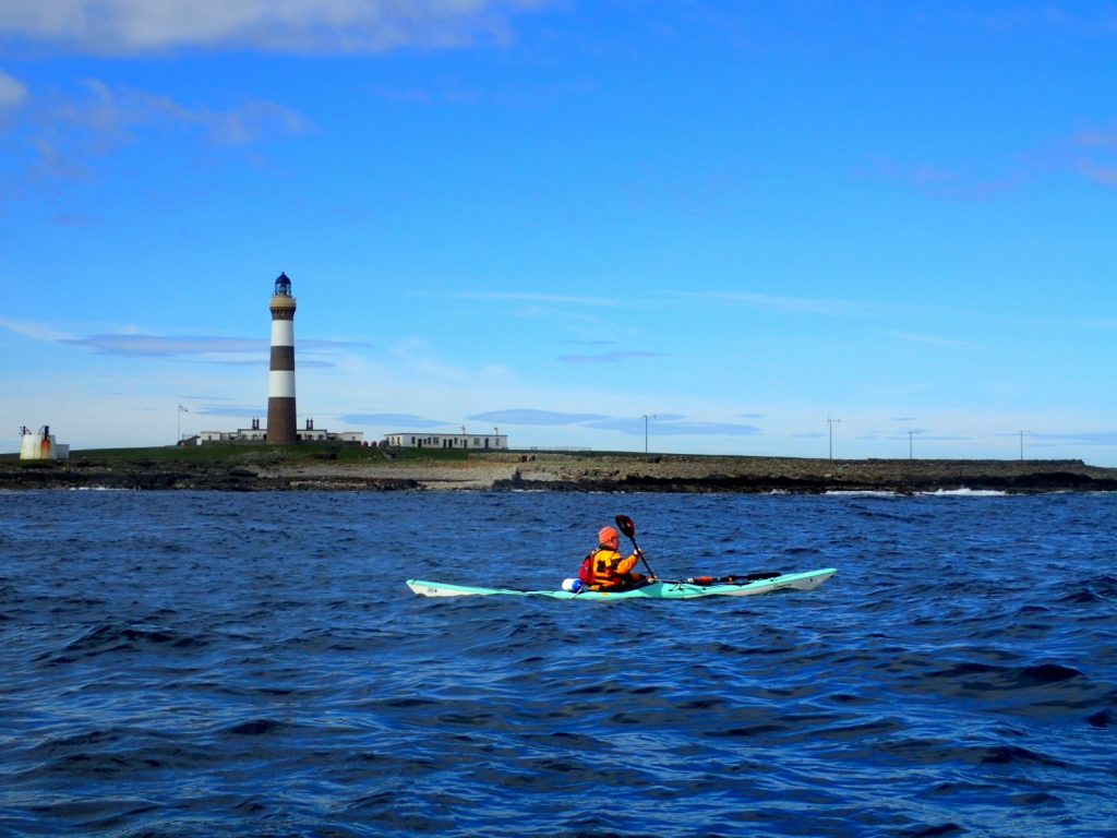
It was a gentle and easy paddle down to Noup Head and we flew down the coast towards the lighthouse in what must have been a large back eddy. The Admiralty tidal atlas, the local fisherman and even David seemed quite relaxed about Noup Head but I had worries. It was a very exposed point in a large swell and we were in the middle third of a near spring tide on the flood. We had to go round the skerries at the tip, as there was no way through the surf in the channel the fisherman suggested. Once round the skerries we turned south and paddled back to the lighthouse and the cliffs.

07. David Musk just about to paddle into the mayhem of Noup Head in a big swell and tide. We had to paddle for a good hour before the conditions eased again.

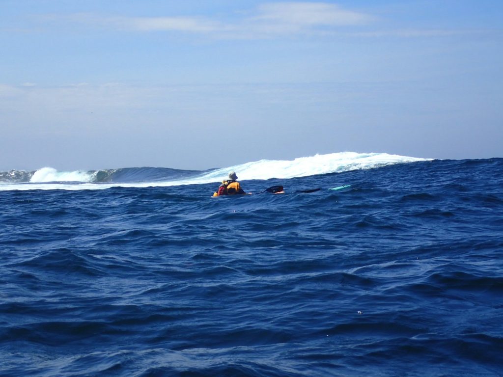
It did not take long for the sea to build. The background swell was perhaps 2 metres, but this was exaggerated by refraction round the headland into 3 metres. Then this swell was smashing into the base of the huge cliffs unabated and bouncing back. Where the arriving swell piled into the swell bouncing back off the base of the cliffs some huge clapotis was created. Frothing claws of surf leapt erratically into the air on one side and deep holes suddenly appeared on the other, and some of our paddle strokes just swept through the air where there should have been water. The kayaks were tossed about like a cork, lurching from side to side and being trust up and down.

We kept a good 300-400 metres out from the base of the cliffs to minimise the effects of this clapotis but it was still intimidating. In addition we were in a tidal stream against us and it was running at about 4 kmph so our progress was worryingly slow. Even if the tide had been neutral it was difficult to paddle fast in these conditions as the boat’s momentum was constantly halted by another climb up a eruption of water. We endured this near-survival paddling for a good hour until at last we made the 2 km to the headland of Russa Taing where the base of the cliffs absorbed some power of the incoming swell on slabs and skerries, which were exploding in huge surf.

I was very relieved when the conditions eased and the tidal current diminished. Noup Head was an imposing and frightening headland in these conditions. I was lucky I was with David Musk and could think of very few others who I could have paddled this section with. David gave me reassurance knowing there was someone else with me, and I had confidence he was at least as able, and probably more so, in handling these conditions. He also confided it had been an intimidating place and a long hour getting through it.

The remaining 10 km of the west coast of Westray saw the conditions gradually ease as the wind dropped right down to a force 2 and the swell returned to 2 metres. We still kept out some 300 metres as it was not so rough here. It was a great shame we had difficult conditions as it would have been fantastic to keep close to the bottom of the cliffs at Noup Head and further down as the coastal architecture was immense, with huge cave and arches, and all covered in a vast bird colony.

When we arrived at the south end of this bit of coast we decided not to cross over to Rousay despite the tidal current being right. It was 2200 hrs and with 42 km under our belts we had had enough. So we rounded Bakie Skerry and cruised up across calm waters for a km in the sunset to Mae Sand. Here there was was a great campsite above the arc of white sand. I was delighted to see that the wind had dropped to virtually nothing and the wind turbines stood still.

The next morning we left around 0900, a good hour or so before slack water and the start of the west going ebb across the Westray Firth to Rousay. I was keen to get across to Rousay and then across the mouth of the Eynhallow Sound before the the full power of the ebb started. It was windstill, but overcast, and the weather forecast was great for the next two days. As soon as we left the protection of Westray and were into the Westray Sound I noticed how much the swell had gone down since last night.

The crossing was quick and smooth. The minimal current did not swing us off course at all and after an hour and a half we had made the 10 km crossing to Rousay quite easily. There was nowhere to land and anyway I was eager to paddle on down the west coast of Rousay and cross the Eynhallow Sound. There was still a 1.5 metre swell and the discharging tide would be ploughing into it no doubt creating some standing waves. Of course further up the channel were two notorious tidal currents each side of Eynhallow Island, the Burger Roost on the south side and the Eynhallow Roost on the north side, but we would only be in the discharges from these.

We cruised down the NW coast of Rousay, David blaise and hugging the coast, and me anxious about the possible tiderace in the crossing, looking for white caps in the eventual standing waves each time the swell lifted me up. I think David thought I was fretting unnecessarily, complaining we were going from headland to headland. As we started across the Sound I saw nothing at first but then I thought I saw a few whitecaps.

Soon enough we were on the edge of a river of tide blasting out to sea. It must have been flowing at around 8 kmph and just short of forming breaking standing waves in the incoming swell. Nonetheless the waves which were being formed were a good 3 metres and quite steep. It was nothing compared to yesterday’s excitement round Noup Head but it was enough to have me bolt upright and alert. The tidal stream was about 1 km wide and it took just 10 minutes to cross it until suddenly we reached the southern edge of it and calm water returned. I think David was surprised just how large it was so far out to sea.

I was expecting another, even bigger, tidal current from the Burger Roost discharge on the south side of Eynhallow Island, and was nervously looking out for it, but it did not materialize. Before long we were approaching the shore of Orkney Mainland just of the east of a huge rampart of cliffs culminating in the 150 metre buttress of Costa Head. Here we managed to find a sheltered rocky bay where we could land and stretch our legs after nearly 4 hours paddling.

08. David Musk about to paddle beneath the magnificent coastline from Costa Head to the Brough of Birsay on Orkney’s Mainland

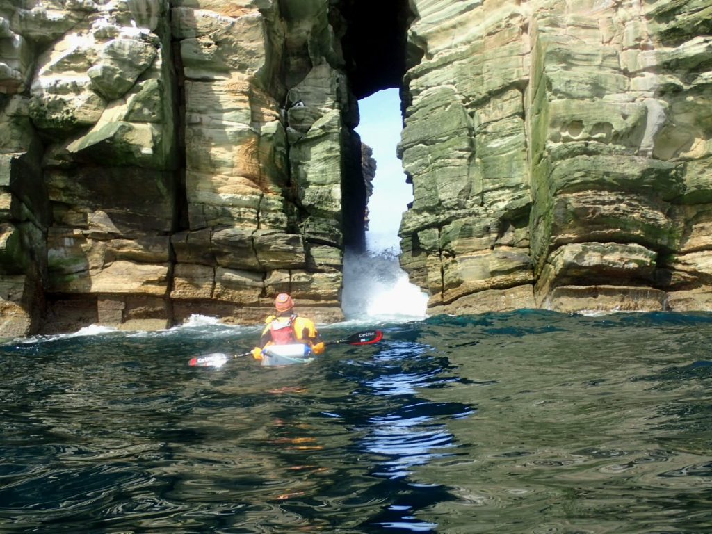
The next 10 km of paddling were perhaps the most spectacular of the trip so far and the sea had calmed down considerably, allowing us to go quite close to the base of the cliffs. They were huge and loomed up over us with their northern faces dark and damp. Here and there were a clusters of ledges dripping guano were groups of seabirds were nesting. The calm ocean was full of rafts of Guillemots and Razorbills. The cliffs built in stature culminating in Costa Head. There was an array of caves and chambers along here but the swell was surging into them so we could not enter any.

Before long we got to an enormous citadel of a sea stack called The Standard, which was covered in birds. It was nearly as high as the cliffs but separated from them by a 40 metre channel which was a bit rough when the bigger sets of waves arrived, but we waited until a calmer period and blasted through into the sanctuary on the other side. From here the impressive cliffs slowly tapered off until we got to the end of this coastline at the Brough of Birsay, a tidal island.

09. The sea stack called The Standard lies beneath the cliffs near Costa Head. It was festooned with sea-birds. The 40 metre channel between it and the mainland was calm enough to paddle through on this day

We had to go round the Brough of Birsay as the causeway was exposed. I expected it to be choppy with swell and clapotis, and disturbed by the tidal current. However it was benign and we could go round side by side having a conservation while all the daytrippers pointed at us and took photos. Just after the Brough was a deep bay with sandy area beneath a ruined palace. A bevy of swans took flight as we arrived on the sand, their laboured wingbeat eventually lifting them.

It was now time to commit to the West Coast of the mainland; some 20 km without the possibility of landing. However the swell was continuing to fall and was now perhaps just over metre, although the waves were still powerful as the period remained long, at 10 seconds, and the wind had effectively vanished. It is rare to get such easy conditions on the west coast.

After we set off the cliffs started to grow culminating immediately in Marwick Head, a 90 odd metre cliff topped by a large memorial to Lord Kitchener whose ship struck a landmine nearby. Below the crenelated memorial seabirds huddled by their thousands upon ledges in the sandstone cliffs. There is concern that this well studied population of seabirds on Marwick Head has seen a large collapse in numbers over the last 30 years.

11. The magnificent coastline on the west coast of Mainland Orkney around Marwick Head. it is rare to be able to paddle this exposed committing coast in these conditions

The remaining 15 km of coast down to Hoy Sound was full of pleasant surprises. Apart from the Bay of Skaill it was virtually one continuous rampart of imposing cliff. The base of these cliffs was riddled with caves and arches and narrow slots, which Orcadians call Geo’s. One could have spent all day cruising down here were it not for the pressure of time to reach the Hoy Sound by nightfall and the occasional larger swell which would surprise you. Here the whole geology of Orkney was laid bare and one could see level upon level of sandstone strata which had been washed onto the lake bed of the vast Lake Ocadie some 380 million years ago.

With 50 km  under our belts we paddled round Brock Ness and the beach at Warbeth came into sight. We had been told the landing was usually OK and it was a nice place to camp. The landing was indeed easier than expected but there  was so much seaweed in the surf my kayak looked like a Highland cow with dreadlocks once I was out of it. We had the tents up in time to enjoy a magnificent sunset over the bay with the glow of the setting sun illuminating magnificent and huge cliffs on the north end of Hoy.

13. Our campspot in the evening at Warbeth Beach overlooking the Sound of Hoy. The headland in the distance are the 340 metre vertical cliffs of St John’s Head

When we woke it was magnificent day with no wind and horizon to horizon blue sky. We decided to wait for slack water to cross the Hoy Sound. It allowed us to linger a bit on Warbeth Beach and we did not want to get to the Brims on the southern tip of Hoy and in the Pentland Firth too early, as we would have to wait for the ebb to finish down there anyway in 7 hours time. So we pulled off the seaweed covered beach at about 1030 and set off for the huge cliffs of Muckle Head on what promised to be an superlative day’s paddling.  

We were a couple of km into the crossing when I turned round to see the MV Hamnavoe ferry leaving Stromness. Within the space of 5 minutes it was bearing down on us its bulbous bow heaving an arc of water into the air. We stopped paddling to let it go some 200 metres to the south of us and I could see passengers looking and waving at us from the sunny deck.

14. Crossing the Sound of Hoy towards St John’s Head, which is just round the corner to the right

On reaching Muckle Head at the northern tip of Hoy, we were delighted to see the swell less than a metre and we could nearly hug the base of the huge cliffs, The next 2 hours paddling were some of the best I have ever had, anywhere, and certainly the highlight of this trip. In places the red sandstone cliffs soared 300 metres above us culminating in St John Head which at 350 metres are the highest vertical cliff in the British Isles, although St Kilda, Foula and Slieve League cliffs are slightly higher – but not vertical.

15. David Musk cruising beneath the cliffs near St John’s Head on Hoy on a superlative morning

Between these towering headlands the cliffs continued unabated with just the occasional high grassy slopes. They were speckled white with breeding fulmars who had imprenatable nests. I could see birds swirling round constantly far above. Lower down were ledges with the auk-type birds. It was an awesome bit of coastline and one felt miniscule beneath it. Just as I thought it could not get better I rounded another buttress and there was Britain’s most famous sea stack. The Old Man of Hoy,  a 137 metre high needle of Old Red Sandstone.

16. The Old Man of Hoy. This is perhaps Britians most famous and spectacular sea stacks and it stands a 137 metres

David was already at the base of it, craning his neck to get a full view. It was a teetering column of red sandstone strata placed on top of each other. It did not look stable and I had heard it was just 250 years old, when previously a huge arch on the original headland collapsed leaving the Old Man isolated. Even 150 years ago a large slice peeled off it’s side and its total collapse is predicted with 100 years. We lingered in the calm sea beneath its splendour before continuing a couple of km down the coast to the cave-ridden headland at Rora Head and then on to a surf landing, small by it’s standards, at Rackwick Bay.

There were a few sunbathers on Rackwick Beach and it was only when we landed did we realize what a sun trap it was. There was mediterranean atmosphere to the beach, but it was virtually deserted.  We still had 3-4 hours before the tide turned and the flood started at the Brims 15 km to the south so we lingered over lunch, before setting off. This section of coastline was nearly equal to that which we had paddled in the morning. The cliffs were not nearly as high but there were a vast amount of caves, arches and geos along this stretch of interesting architecture. We had plenty of time to lap it before we reached Tor Ness.

17. The coastline south of Rackwick Bay was almost not as high as earlier in the morning around St John’s Head but it was as impressive and riddled with caves, arches and geos.

I expected there to be a little tide against us here but there was nothing discernable. I was sure then it would be possible to paddle against the end off the ebbing tide at Brims Ness. So I was quite shocked when we got there in another 20 minutes to see the flood was well underway and there was quite a bumpy tiderace to surging east. Luckily it was in our favour and it was already going at 6 kmph.

We had both independently calculated the tide would not turn for another hour, but here we were and it looked as if had turned an hour previous; 2 hours earlier than the Admiralty predicted. Indeed I had noticed that it often turned up to an hour earlier than predicted but Brims Ness was exceptionally early. My conclusion for paddling in Orkney regarding this was one should always be an hour earlier that the predictions-and then perhaps another half hour before this adjusted.time. If it was too early the worst you had to do was wait an hour, but if you were late you would be punished and might have to wait 5 or even 11 hours.

We now flew down the coast of South Walls and covered the 6 km in about 40 minutes to reach Cantick Head. We had intended to go round the lighthouse here and into Kirk Bay where there was a poignant memorial to the 8 lifeboat men of the Longhope Lifeboat who died while on service attempting to rescue the shipwrecked SS Irene in March 1969. However, we found a camp spot near the lighthouse and walked up to the memorial later to pay our respects.

02. A Memorial to the lifeboat men of Longhope

I was apprehensive about the weather, as the last time I saw a forecast 3 days ago the weather for tomorrow did not look good. Now we had a phone signal I was delighted to see that the forecast was perfect. We would be able to hop over the Pentland Firth via the Islands of Swona and Stroma. We calculated our times and estimated we had to leave at 0600, some 6.5 hours before high tide Dover, for the 6 km crossing to Swona.

As promised the weather the next morning was superb, however just over the Cantick peninsula we could hear the roar of the ebbing tide which was a bit disconcerting. As we packed up the roar slowly diminished and and by the time we set off our nerves were more settled. We paddled round the beacon at 0600 and were quickly carried out into the Pentland Firth by the tide flowing south out of Scapa Flow through the Cantick Sound; which should have been flowing north against us!.

20. Crossing the North Channel of the Pentland Firth from Cantick to Swona. This was about half way across the 6 km in ridiculously good conditions

Once in the Pentland Firth the tide seemed to be in slack water so we set a transit line with the north tip of Swona and the southern tip of South Ronaldsay. We kept a good speed as if there was some tidal assistance and kept a pretty straight line and within the hour we were approaching Swona. There was a stronger current flowing north up the west side of Swona due to the flood splitting around Swona, and it became quite turbulent towards the tip. However the eddy on the north east corner had not formed yet and we easily broke out into the calm, flat, sunny east coast and cruised a few hundred metres down to The Haven, a natural harbour were we easily landed. One banana skin down two to go.

21. The Haven on Swona is a deep inlet on the NE side which the islands once used as their harbour before the island was abandoned

We fine-tuned out departure calculations. I was keen to get the last of the flood tide as I remembered how much the last of the ebb tide helped me north 2 weeks ago and was hoping for the same, but this time the southerly component. We calculated it for 1130, an hour before high water Dover, but I was keen to increase this to one and a half hours and leave at 1100.  It meant we had 4 hours to explore the Island.

Swona was abandoned a decade or so after it’s neighbour Stroma further south. However there was just one family living here and the abandoned houses seemed to be in a worse state on the path to ruin than those on Stroma, and there was no animal husbandry here as there was on Stroma with its sheep.. Old farm implements lay outside the tumble down byres and most of the houses had their roofs collapsing. Those which were open were full of cow dung, in some places up to the window sills. It was a sad scene and I could imagine the community here on a day like this 100 years ago where there would be laughter and fun, all of which was now in ruins.

The last family to leave was the Rosie’s; a sister and 2 brothers, who left for South Ronaldsay in 1974. We found their house and went in. The floor was full of mud but there were letters and receipts in tins, and even a christmas card on  the table. The large stones slabs on the roof where falling off and no doubt soon the weather would ruin all in here. When the Rosies left they turned their herd of Shorthorn-Aberdeen Angus cross of 8 cows and a bull loose. As we wondered about the ruins I saw two skeletons from the herd, but no live ones. We had been warned to stay well clear of them as they are now feral with no human contact.

28. The herd of feral cattle on the Island of Swona. They were turned loose some 45 years ago when the last inhabitants left and are not used to any human contact.

We walked to the south end of the island where there was a small lochan and a large colony of terns. Wildflowers grew everywhere especially orchids and ragged robins. The island looked peaceful and serene in the sun, especially down this end way from the recent house ruins. There were also ruins down this end but they looked older black houses or livestock corrals. In the middle of the island we spotted the feral cattle. I counted 17 of them including 3 calves.

Beyond the south end of island was a skerry called the Tail of the Tarf. The tide was ripping past here creating large overfalls and waves and a huge eddy to the SW of the island. Beyond the overfalls was the Middle Sound of the Pentland Firth and it was a smooth river of unstopable water flooding eastwards. 6 km to the south was the Island of Stroma out next step. The water in the Middle Sound was not moving with the same speed as I remember from 2 weeks ago and although both were near spring tides this one had a smaller coefficient (tidal range).

24. Looking from the Tails of the Tarf on the south tip of Swona across the Middle Sound of the Pentland Firth to the island of Stroma some 6 km away. The broken water is just the eddy line between the eddy on the SE side of Swona and the flood tide

The was a small colony of puffins on a steep hillside by the South Clett, a stack I remembered from my journey north 2 weeks ago. It was easy to sit above them and watch them come and go, many with mouthfulls of sandeels. In the channel between us and the South Clett stack there were seals swimming and hunting for fish in the south going current caused by the massive eddy. Indeed in the half hour we were here the current increased significantly.

27. Puffins on the steep grassy cliffs between Swona and the South Clett stack. The puffins were living in burrows nearby

We went round past the cattle again and headed north passing a “gloup” – a sea cave in which the inner portion of the roof had collapsed leaving an arch and a hole and returned to the boats. We did not launch until 1115 and I felt we were already late, but David thought we had good time. When we got to the South Clett I was horrified to see the current had reversed and it was now flowing strongly against us. I powered up it concerned the main ebb had started already. If we had missed the last of the ebb we would be resigned to spending another 5 hours here.

I needed to get a bigger picture so landed and ran up along the edge the tern colony getting pooped on and dived bombed frequently. At the top of the slope I looked out across the Middle Sound to Stroma and could see the flow had nearly slowed to a halt. We were later than I had hoped, for but I thought it was still manageable. We set off at once.

My fears were slightly unfounded as there was still a bit of an westward going flood. It took us south at a fair speed and were were both doing 8-9 kmph. We let the flood take us slightly to the east as I did not want to get caught up in the imminent ebb which would sweep us past the north of Stroma and into the Swelkies which formed there. After some 40 minutes we were level with the lighthouse on the north end of Stroma and then veered towards the most easterly point of the island. By the time we got there the tide was ebbing, but it took now us in the right direction down the east coast.

30. Back at Huna harbour after two and a half weeks around the Orkney Islands

We rode it into the Inner Sound and decided to skip Stroma and its southern harbour altogether, and cross the infant current to Huna. it was remarkably easy and we hardly had to ferry glide across any of it. This sound was just 2 km wide and we were across before we knew it. Indeed it had just been and hour and a half since leaving the tern colony on the south end of Swona. I pulled into the small harbour at Huna and powered up the sandy beach coming to a halt. It was the end of a great trip. I had my car nearby at a garage and the owner was relieved to see me, as he was considering calling the police. Within a couple of hours the car was loaded and David and myself started the huge drive to Edinburgh, via a few stops, arriving well after midnight and 22 hours after we started our day on South Walls.

31. The completed route around the Islands of Orkney

Back

I had not slept well having had been worried of what might go wrong but looking 3 km across the Inner Sound to the Island of Stroma my worries evaporated.  A vast determined river of water flowed steadily past with no whitecaps, standing waves or boiling eddies. Perhaps the sirens were luring me in and once I had been seduced I would be cast to the Swelkie whirlpools on the north side, but from where I stood it looked fine once the 10kmph river had eased towards the end of the flood tide. I left Huna 0940, which was high tide at Dover, on a still morning under a mackerel sky. The paddle across was totally benign with just a hint of a current as I reached the SE corner and made my way up the east coast for 2 km to the jetty at Nethertown, where I pulled the kayak up the seaweed covered ramp.

I now had nearly 5 hours to explore the Island of Stroma before my next leg across the Middle Sound. I took off my drysuit, grabbed my camera and had a quick look around the abandoned houses by the jetty. Solidly built of stone walls with large stone slabs on the roof most were still standing but the vicious winter storms had lashed rain against them and water had now rotted many of the roof timbers and most roofs were collapsing. Around the houses, in the old gardens, was a riot of nettles where birds were nesting. Beyond the houses were lush well-ordered green fields, luminous with yellow flowers where timid sheep and wary geese grazed.

01. The green fields on the abandoned Island of Stroma with a few of the houses on the main road falling into disrepair

I walked up to the “main” road, a track which went north-south down the spine of the island. Once there I followed it south past all the abandoned croft houses to the war memorial and church. 7 people from this island died in each of the great wars and I could not help but feel what a waste to be wrenched away from this caring self-sufficient community to be blown up in unknown parts of Europe. The houses themselves too oozed sadness, even on this sunny day. Most doors had disappeared and now the sheep sought refuge in them during storms. There were even fulmars nesting in some. The church was now a barn full of fencing materials and lambing pens. The attached manse was locked but in reasonable repair. I looked through the kitchen window to see the tools of lambing on the table. Powdered milk cans, bottles of veterinary medicines, an empty bottle of a perfunctory whiskey and beer cans.

Over 1000 people had lived on this island in the middle of the fiendishly strong currents which swirled past until 50 years ago when it was abandoned. Where there had once been laughter, singing, hard toil and endless crafts, were now just crumbling houses and semi-feral sheep. Those from this land were now scattered across the globe but with many probably remaining in Caithness on the mainland across the currents.

O2. Nesting Fulmars on the Island of Stroma. If you get too close they will project a foul mix of bile and fish oil at you

The people’s loss was the birds gain. On the moorland and in the longer grasses were snipe and I could hear them drumming everywhere. Flocks of geese grazed in the fields between sheep and lapwings thrived on the meadows. I walked over to the west coast from the ill-repaired church to where I knew there to be sea cliffs and bird colonies. Great Skuas watched me and wafts of guano smell drifted up from the bird colonies. When I reach Red Head I could see 100’s of fulmars nesting on the very steep grassy slopes and 1000’s of guillemots nesting on ledges on the eroded sandstone terraces below. The thuggish skuas started to dive bomb me as went and I called their bluff by crouching down as they started their approach and then leaping into the air at the last minute. Despite their size they were agile and acrobatic birds and they pulled up flaring their wings, and veered off in fright. I walked up the length of the west side on top of the cliffs, sometimes crimson with drifts of sea pinks, looking down on the bird colonies and out to sea where the ebbing  currents rushed past at 15kmph.

At the north end of Stroma is a lighthouse at Swilkie point. Here the current was racing past at perhaps 25kmph. It was a ferocious sight with much white water and confused seas. There was a strong eddy below downstream of the point and this had formed a whirlpool. Apparently there is an even bigger one on the other side in a flood tide. Swilkie is probably from the Norse word Svelge, meaning Swallow. It was no place for a kayak, or any other boat really. Beyond the lighthouse and the roaring tidal rapids was the 6 km of Middle Sound between me and my next landfall on the Island of Swona. It was now flowing west on the ebb tide at 15kmph, but again without standing waves or white caps, which was reassuring.

05. The swirling waters of the Swelkies off the north tip on Stroma. The island in the dostance some 6 km away is Swona; my next destination when the tide eases

I returned to the jetty and had a few catnaps of sleep on the concrete pier in a sun trap. Terns screeched overhead each time each time I got up to check the flow which was slowing with each half hourly viewing. I should have left at 1540, 6 hours after high water Dover, but went half an hour earlier in a bid to avoid the east going floodtide on Swona which might sweep me past the Pentland Skerries and out into the  North Sea. It paid off and I went shooting up NNE on the last of the ebb. My GPS was showing a steady 10kmph and I was going where I wanted. Within 20 minutes I was over halfway and it took just another half hour before I was fighting the last of the west going ebb tide to keep east of The Tails of the Tarf, the south end of Swoma. The sea was a bit lumpy here but I was expecting much worse.

I paddled up the east coast below cliffs teeming with nesting fulmars and puffins in the grassy slopes above. There was an impressive stack, Sooth Clett, I could sneak on the inside of disturbing some sunbathing grey seals as I headed up to The Haven where I intended to land and explore Swoma for 5 hours until the tide was ready to allow me the final leg to Burwick on South Ronaldsay.   

However half way up I noticed there was still some ebbing current so I got greedy and decided to skip The Haven and head over to Burwick at once. I made good progress towards the cliffs south of Barth Head and was halfway across before I knew it. I then eased the angle of attack and started heading west hoping the infant flood would carry me south and the two forces, mine and the floods, would bring me to The Wing, the entrance to Burwick harbour. Well beyond that I could see the distant beacon marking the Lowther Rocks Shoal off Brough Ness. I was in cruise mode daydreaming of a nice campsite in Burwick with a crossing of the Pentland Firth in near spring tides behind me.

08. Heading east from Swona over to South Ronaldsay without a care and oblivious to the strong tidal stream I was nearly caught in and swept past my destination of Burwick

However suddenly the Beacon on the Lowther Rocks seemed to be appearing at an alarming rate and The Wing was fast approaching. I had been caught out and was being swept SE on the flood tide and was still half a km offshore. With a dry mouth I sat bolt upright and started to paddle flat out. I had to otherwise I would have got swept between the Lowther Rocks and Brough Ness  in a tide race where small standing waves were already forming. A fishing boat was coming north through this gap and I could see it struggling. It took 15 minutes of a bicep pumping fury to get out of the grip of the 10kmph conveyor belt of water and into the stiller waters of Burwick Bay. I got there at same time as the fishing boat whose two crew members were watching me and could have had a wager on whether I would make it or not.

After landing I went over and chatted with them as they put rubber bands on the claws of a vast tub of Lobsters, well over 100 of them. “This fella here is probably as old as you” said the more burly fisherman holding up a huge lobster. We had a banter for 20 minutes and some tidal advice about the next 5 km. “You had best leave at low water Dover” (they all used Dover times here), which I already suspected. It was hardly worth putting the tent up as I would be off again in 9 hours. It was to be a dry, still night so I just cowboy camped, like a salty hobo, behind a wall near the passenger ferry terminal. I slept like a log with the recent lack of sleep and the lifting of anxiety, with the alarm set for 0300.

When it went off I was out for the count but the urgency of catching the tide spurred me into action. I slid the loaded kayak down the rocky foreshore on empty fish boxes and was off by 0415, 6 hours before high tide Dover. An otter saw me out of the harbour and into the infant east-going tidal flood stream. I shot through the ripples, where standing waves stood last night between Lowther Rocks and Brough Ness, and flew past the bottom of South Ronaldsay,  disturbing a few seal herds basking on rocks. I was chuffed my timing was impeccable. I rounded the SE corner at Old Head in benign water and started up the east side towards the looming Halcro head. To my left was a deep bay called Ham Geo with a pebble beach at the end where the burly fisherman last night said I could see shelter if needed.

09. The great cliffs and bird colonies of Halcro Head on the SE side of South Ronaldsay and out of the main tides of the Pentland Firth

However it was a beautiful morning and a beautiful sea and I really enjoyed my cruise up the next 8 km. Initially it took me past steep striated sandstone cliffs with eroded ledges perfect for Guillemots and Razorbills to nest on. Around Halco Head and Mouster Head it was a kayaker’s dream landscape. Dramatic cliffs and stacks, riddled with clefts and caves rose up from the calm sea. Seabirds jostled noisily on the ledges dripping with guano while many of their brethren formed large rafts of birds on the smooth sea and I had to carve a path between them. It was just perfect, and I was now away from the terror of the tides. I pulled into the white sands lining Pool of Cletts Bay after this awe inspiring coastline at 0615 with 12 km already under my belt.  

The next 14 km of coastline to the sandy isthmus between Orkney Mainland and the Deerness Peninsula were quite unremarkable. I headed from headland to headland in a light northerly wind while inland the causeways of the 4 Churchhill barriers connected the string of islands, and blocked any access into the huge harbour of Scapa Flow from the eastern side. My lack of sleep was catching up now and I struggled to keep my eyes open, getting the nods a few times.

I stopped at the Deerness Isthmus where a oystercatcher chick was struggling to get over boulders towards grassy cover, while it’s noisy parents harassed any blackback or herring gull which flew nearby. I sat at one end of the delightful sunny beach and watched a mixed raft of blackback and eiders pecking the shoreline seaweed gently lapping in the tiny waves.

11. The beautiful quiet waters of Taracliff Bay on the Isthmus of the Deerness Peninsular were is stark contrast to the ferocity of the Pentland Firth. It was a delight to relax and watch the small black headed gulls and eider ducks forage in the floating seaweed

The journey up to Mull Head was a slow return to striated sandstone cliffs again, but the the increasing northerly wind slowed my progress as I ploughed through what felt like treacle. The spectacular average of 9 kmph this morning was now down to 3.5 kmph. There was some respite from the slog at Tammy Tiffy with it’s cliffs and The Gloup, a sea arch and vent before I approached Mull Head. Here I realized the tide was ebbing north with increasing determination and the NW wind was now a force 4 and these two would meet at the point and this alerted me to sit upright again.

However Mull head was not as dramatic as I feared but I could not enjoy the seabird colony as I raced past. My plan had been to ride the tide to Shapinsay Island but the wind against tide was kicking up many slow steep white capped waves I shunned the 7 km crossing and went for the timid option of heading over to Rerwick head on Tankerness Peninsula first. Even these 5 km were a very wet ride with plenty of salt spray lashing my face at every slap of the kayak’s bow as it tipped off the wave. It was long grind over the outer jaws of Deer Sound and these hard fought 5 km took nearly two hours. I found a cleft, or Geo as they say in Orkney, to land in  at Orwick and stretched my stiff legs. It had been a long day and it was only 1500hrs. As I lingered here and looked at the charts the wind eased and the tide slowed. I sat on a sunny rock slab under the perplexed gaze of nest fulmars just above and was tempted to sleep, but at the appropriate tidal time around 1630 I had to leave again for the final leg of the day which was just a short hop over Shapinsay Sound.

The weather and tide were now so diminished the crossing was easy and by 1730 I had arrived at the white sheltered sands in the Bay of Sandgarth. I was dog tired after my 13 hour 52 km day  but still had to wrestle my kayak up the beach and then boulders above the sands to clear the highwater mark. I made a runway of wet seaweed up the beach and found an old tire to slide the kayak over on the boulders which saved me emptying and carrying it. Once the tent was up and I had eaten I looked at the charts and saw to my disappointment I would have to set the alarm for 0300 again, in just 6 hours time.

Again I was in a deep slumber when I alarm woke me. I had to get up to make the tide again. By 0430 I was afloat on another beautiful still morning. I still had an hour of ebbing tide to slingshot me over the Stronsay Firth and felt relaxed about it given the weather and my timing. I passed the skerries on the SE corner of the Island and set my sights on a wind turbine above Rothiesholm head some 10 km away across the firth. I past The Foot on Shapinsay where there was a natural arch curving up out of the sea right at the headland.

I looked down at my GPS and to my astonishment and delight I was doing 10-11 kmph as the end of the ebb carried me up the Firth. I was not too worried about over shooting Rothiesholm as I knew the tide was due to turn soon and it would carry me south again. Before long I could see the blades revolving on the turbine and make out clefts on the red cliffs on Rothiesholm Head. I was still flying along at 8-9 kmph now and still on a direct course. It was more that I could have ever hoped for. It was only when I was about 2 km from the headland did I slow down to my normal speed and then to my delight the tide caught me and started carrying me west towards Tor Ness at 10kmph again. This was not planning, one cannot be so accurate with the tidal stream predictions, this was good luck. Before long I was round Tor Ness and heading over to the greenest fields, even by Orkney’s verdant standards, I have ever seen on Holland Farm where there was a beach.

I tried to take credit for my swift crossing, but knew I had just put myself in roughly the position I wanted and luck did the rest. It was only 0700 and I was already on Stronsay where I intended to spend the night. I now harboured greedy thoughts again and considered pushing on to Kettletoft on Sanday Island where I could hunker down for 2 nights before the expected gale due to arrive in the early afternoon, as there was no sign of it yet.

12. A large grey seal colony taking to the water after I surprised them at Lamb Head on the SE of Stronsay Island

I past many more seal colonies as I reached Whale Geo on Lamb Head on the very SE corner. I later found out a cave goes right through this headland to the Hell’s Mouth cave on the north side. As I rounded the headland the great vista from Lamb Bay to Burgh Head quickly unfolded before me. There was negligible tide, a calm sea and a rampart of high cliffs, in many places white with guano, before me. I could see I was going to enjoy this 2 km section.

I skipped across Lamb Bay looking into the arches which supported the 3 different entrances into a dark chamber beyond which was Hell’s Mouth, but unfortunately did not make the detour to venture in. One of the joys of sea kayaking is going into caves, but it is very time consuming and in Orkney I have already passed 100’s. Instead I chose to cruise up beneath the cliffs. I passed 2 Skua pecking at the chest of a Guillemot they had just killed. These thuggish birds have gathered here to prey on the eggs and chicks of other seabirds, and until they are abundant have to ambush the adults to survive. They are quite wasteful and often just eat the liver of the adults leaving the rest for gulls.

13. A curious raft of Guillemots come over to inspect my kayak off Burgh Head on the steep east coast of Stronsay

Vast rafts of Razorbills and Guillemots were already on the water ahead. Perhaps they knew the Skuas were not hungry anymore as they seemed relaxed when I approached. Indeed in the middle of one raft I stopped paddling and kept still and they started to gather round. Once I lifted my paddle again those nearby took off  and induced a panic throughout the whole raft so a few thousand birds suddenly took off in a crescendo of splashing and flapping.

14. The cliffs at Burgh Head were riddles with caves, caverns, pillars and arches and were the most spectacular I had seen on Orkney so far. There was also a large bird colony here of the ubiquitous Guillemot and also nests of a large colony of the noisy Kittiwakes

Burgh Head was perhaps the most spectacular of the headlands I had passed so far on this trip. A small stack lay at the foot of the cliffs and I could paddle between. The cliffs themselves were riddled with chambers, pillars, arches and caves. The winter storm waves would slam into these and exert tremendous forces on this open structure and one would imagine it is only a  matter of time before a crucial pillar breaks and the whole edifice comes tumbling down. Within the structure there were numerous nesting sites honking with noise and guano. I sat at the foot of the edifice in calmish waters photographing and looking at the birds.

When I moved on I pretty much cut over Odin Bay to Odness Point. This was a great shame as I read afterwards I missed the Vat of Kirbuster, reputedly Orkney’s finest Gloup, which is a cave where the inner roof had collapsed leaving a hole. It was a good reason to revisit. The cliffs petered out as I past the greenest of fields to reach the rocky slabs at Odness.

I now just had Mill Bay to paddle across to reach one of the best harbours in Orkney at Whitehall. The bay was very shallow and was until a hundred year ago a forest. The trees trapped  drifting sands and the kept the soil together. When the trees were cut down the unprotected sands and soil were washed away and the sea claimed the bay.

On the north side of the east harbour entrance was the Island of Papa Stronsay, home to the Transalpine Redemptionists, an old order of the Roman Catholic Church. Their monastic pebble-dashed cabins were arranged in an ugly grid in the south field. Further in were the remains of the old lifeboat station ramp. Further i  again the bay opened out and on the south shore was the village of Whitehall. There were 2 jetties, one for the ro-ro ferry and one for the fishing boats, with their jaws to the outer harbour only open to the north. The bases of the jetties were 300 metres apart and along this was a sea wall tope with the “main” road and beyond the road was a row of about 25 houses. One was the hotel. It was still early at 1100 but the southerly wind was increasing steadily.

15. The village of Whitehall on Stronsay had a wonderful community bunkhouse which was my shelter from “Storm Hector” for two nights. Although storm Hector was just a good gale despite Met Office hype.

On landing I was accosted by a slightly unhinged English lady who did not have a good word to say about anything. She did however make me aware of a hostel and cafe opposite the dull looking hotel. I asked at the cafe and the extremely helpful lady showed me round. It was wonderful. I still had the chance to continue to Kettletoft on Sanday before “Storm Hector” arrived but this was too nice a place to pass by and a great place to hunker down for 2 nights.

Within an hour the kayak was secured beside the community owned hostel/cafe, what I needed was in my en suite bunkroom, my clothes were in the washing machine, I had showered and was eating a the cafe. I then had a small wander in the village and had a 5 hour siesta under soft cotton while the rain lashed the window.

When I woke in the evening I dashed over to the empty hotel. In contrast to the modern, spacious, bright hostel it was dark and tired. The owners who had it for 5 years had moved up from Kent and were clearly sick of the place now and the hotel was for sale. There was not one vegetarian thing on the menu, but the lady made something up for me. I returned to the hostel and made myself at home as I was the only guest. The wifi worked flawlessly and I managed to call David Musk who I suspected might be joining me on some of this kayak trip. He had just finished going round Islay. He was already in Kirkwall with his wife Hazel in their campervan and was intending on coming out to Stronsay tomorrow.

The next day I woke with “Storm Hector” just arriving. It was glorious to sit in the warmth at a table and watch the rain lash down and spray being whipped off the whitecaps in the harbour through the window. I would be going nowhere today. The weather was so poor the ferry bringing David and Hazel over in their camper van was cancelled.

David and Hazel did manage to get their campervan and David’s kayak on the ferry early the next morning and they arrived for breakfast. The wind had dropped down to a force 4 now. We spent all morning chatting, looking at charts, drinking coffee in the cafe and packing boats and eventually left at midday. By now the wind, which was forecast to drop had increased again to a force 5, and there were small whitecaps all over the harbour. We decided to head off nonetheless.

Once outside the natural outer harbour of Papa Sound it was a good force 5. We opted to keep further west than initially intended and cross from the Holm of Hulp island across the Spurness Sound to Hacks Ness on Sanday.

The crossing was quite exciting with a steep spray-filled chop which frequently soaked us. The small west-going ebbing tide (by Orkney standards) counteracted the east-going wind and waves and we kept a straight line towards Quoy Ness, when we turned and headed west. The conditions were at the upper limit of comfortable and it would have only needed the wind or tidal current to increase a bit to tip it over into survival paddling.  

Once we turned and started running with the waves and surf north of the main tidal current we shot off. The growing swell was moving quite fast but on occasions one of our kayaks was fast enough to stay on a wave’s face and we accelerated off with the nose skimming across the surface for an exhilarating 100 metres of so, until the wave overtook us or it petered out and we came off the plane and the boat sunk down to the plimsoll line again.

It was a quick 10 km as we shot past Elsness and Tresness peninsulas and snuck into to a sheltered cove, called The Crook, at the very west end of the long, bright white sands of Newark Bay.  Behind the shelter of a dune it was warm in the sun where we had a snack and pumped some water out of the boat’s cockpits which had sneaked through the spraydeck seals. Sanday was an island of beaches and this was perhaps the biggest with the far end disappearing into the haze some 8 km away. Beyond the end of the beach one could just make out Start Point lighthouse.

16. Pumping out excess water after a very bumpy crossing from Stronsay to Sanday

We followed the curve of the bay down past Newark keeping far enough out to avoid any surprise surf from a rogue wave. With the wind behind us we were carried down across the next bay past Lopness point and along the skerries towards the fast approaching lighthouse with it’s unique vertical back stripes. I glanced at the GPS and we must have been in a good current as we were doing well over 10 kmph and being carried towards the headland, were we both expected some turbulent waters.

Soon we could see the large curling dark waves of the tide race but there were remarkably few white caps on them, meaning they could not be that steep. We also noticed there was a calmer area between the tide race and the land and we both shot into that and before long were paddling north past the lighthouse into Scuthvie Bay.

Our plan was to paddle up to Toftsness and have a pause before crossing the banana skin of the North Ronaldsay Firth at slack water. However, we must have been caught in an eddy because it was a slow laborious slog across the bay to the point, meaning we we so delayed we had to skip the pause and head north before reaching Toftsness.

It was pretty much slackwater in the firth as we set off but the eddy still held us back for a while. Only when we were north of Toftsness did it release us and and allow us to reach our cruising speed of 6 kmph.

The wind had dropped and with the slack water it was quite a benign crossing but the land still took a while to approach. We reached Point of Burrian and then headed east round the South Tiang skerries, which were full of seals who crashed into the water on our approach. Just beyond was a beach with a sheltered corner to the south. We landed here both pleased to be on North Ronaldsay.

Previously North Ronaldsay had over 1000 inhabitants and good agricultural land was scarce. Now it has less than 50. Due to the previous scarcity a 14 km wall was built around the entire island to exclude the unique North Ronaldsay sheep from the cultivated land. The sheep are able to live off seaweed alone and indeed too much good grass can induce copper poisoning in them. The ancient wall is still in reasonable repair and is a Class 1 listed heritage structure, and as such is preserved. We camped on top of it. Two locals cycled over to chat to us in the evening and were astounded we had kayaked over. Before bed in the glorious sunset I looked back at the sound were had paddled over and it looked nasty.  The vast body of east going tidal water was smashing into the southerly swell and the sea was jumping with erratic surf. White claws suddenly erupted out of this mayhem, grabbing at the grey sky. It was lucky we were not 2 hours delayed. After looking at tidal atlases and tide tables and the maps we did not get to bed until near midnight but the alarms were set for 0545.

17. The campsite on North Ronaldsay looking north to the lighthouses to the tip of the island

We were on the water for 0845 (6 hours before high water Dover) to catch the diminishing tide round the top. It was a beautiful day as we set off across Linklet Bay bright eyed and bushy tailed towards Dennis Head, where there was an old lighthouse.  

We rounded this keeping out a bit to avoid crashing surf on the skerries and pulled up to north to the iconic lighthouse on the Northern tip of North Ronaldsay and indeed the Orkney Islands. There was a tremendous surf pounding Seal Skerry to the north, with huge waves, but luckily this attracted the swell and allowed a calm passage in the channel between Seal Skerry and the lighthouse, which we paddled through easily; but I noticed the tide was already against us! It must have turned early.

18. David Musk paddling round the North Ronaldsay lighthouse in surprisingly good conditions. There was a skerry further north which the lage swell was spent on

We paddled quickly over to Green Skerry, giving a wide berth to the massive breaking swell. Then on to the NW corner where there was skerry called the Altars of Linnay. It seemed to attract the swell, which was coming from the NW, and refract and exaggerate it as it wrapped round the skerry to produce truly huge waves.  We paddled towards them, watching in awe, as the benign 3 metre swell was concentrated into 6 metres which in turn, rose up into an even higher pyramid of light green water and spewed forth a crest of water over a tube before the whole edifice came crashing forwards in a biblical eruption of surf. It would have rolled any trawler or lifeboat over and dashed them against the rocks. Even a freighter would have been wrecked. After 6 or so of these reverberating explosions there was a set of 3 or so even bigger ones. We were paying attention!

We gave them a wide berth and headed about half a km out to sea to round the point until we could see down the tempestuous west coast of North Ronaldsay. After much adrenaline inspired paddling however we ground to a halt and were going nowhere. The strong tide was against us. It would have been futile and foolish to continue so after a quick and unanimous consultation we decided to beat a hasty retreat to a beach between the Green Skerry and the lighthouse.

Half an hour later the boats were on a sandy beach, we were out of our drysuits, clambering over the sheep wall, and heading to the cafe at the lighthouse to consult the charts again and see why we were a good hour too late for the tide.

19. After pausing our attempt to go round the NW corner of North Ronaldsay we wenr for a walk until the tidal stream changed.

The cafe was by a display of weaving and lighthouse history. It was run by an vegan lady whose entrepreneurial ideas were slightly thwarted by her employers, The North Ronaldsay Community Trust. We sat and watched the tide race around the Seal Skerries, but could just not figure out why we were an hour late for the tide.

20. The 5 metre swell on the NW corner of North Ronaldsay was producing some hugw waves when they crashed on the skerries. Here is David Musk negotiating one set

We returned to the kayaks in good time, launched, and skirted round the huge surf on the Green Skerry and gave the Altars of Linnay another go. The waves were just as big and frightening as before but we gave them a wide berth again and the infant ebbing tide carried us round and south down the west coast. There would have been no chance of landing anywhere here at all. At the SE corner the swell started to build again from the usual 3 to 5 metres and then tower up and crash on The Lum skerries.

We gave them a wide berth again and then paddled east fighting against the building west going tide to reach the turquoise sandy calm of South Bay.  We had to wait a good few hours for the tide in the North Ronaldsay Firth to build and then diminish before we could cross this Firth so we went up to the Bird Observatory. Here the lady of the couple we spoke to last night came out to greet us with great warmth and admiration. The Bird Observatory is a wonderful refuge with its warm sunny rooms and would have been a great place to stay, were we not obliged to take the window of opportunity at the next tide change.

Wary of what we had seen with the east going tide last night we left in good time but with the risk of getting swept north. We were perhaps two hours early.  We initially ferry-glided south to Toftsness on Sanday and then relaxed when the northerly component of the tide was crossed and let the end of the east going tide carry us to The Riv, a line of skerries protruding out from the north of Sanday. We arrived on schedule pleased with our calculations and course. To add icing to this congratulatory cake there was an easy passage through a calm channel at the base of The Riv, meaning we did not have to go round it and endure the surf and tide.

There was just one more bay to cross, another channel, The Inner Sound, to sneak through at the base of the next peninsula, called the Holms of the Chapel, before we could home in on our campsite. However when we arrived at the Inner Sound the tide was out and the waves on the far side looked prohibitive anyway. So we decided to head north to the Outer Sound and try that. It was the same story. So we decided to go round the north of the last island.

Within the space of a few hundred metres the sea swell went from a metre to 3 metres again and it continued to grow. What we hoped would be a simple rounding of a calm headland turned out to be a bad as the Altars of Linney on NW North Ronaldsay. There were deep troughs in the swell, which were valleys of full of dark ripples. We were usually out of sight of each other save when we were both on the crest of this mountainous swell. Just a few hundred metres south of us the green mountains reared up, to perhaps nearly 8 metres, and spray peeled of the crest of them as they ended their ocean journey from a far of gale in a crescendo of violence. Beyond them was a poignant reminder in the form of a twisted and battered freighter whose bent wreckage was lying draped over the rocks.

There was a tide against us to fight here and we made slow progress round this headland, aptly called The Lotheran. Slowly we pulled our way south with tired biceps until level with the island and then past it to the Outer Sound and a bit later the Inner Sound. It had taken well over an hour to get back to the Inner Sound and now were were on the west side of it. The irony of it was had we waited perhaps just 20-30 minutes and had a snack we could have let the tide flood it, the small surf here diminish accordingly, and we could have paddled through without a care and avoided the risky rounding of The Lotheran.

It was a simple paddle now down the rest of the peninsula across North Bay and into a very sheltered beach in the Bay of Brough. We got there around 2300, well after the glorious sunset, at the end of an epic day. The tide was high so we could pull the boats up piles of rotting seaweed onto a flat grassy area between the sea and some small freshwater ponds. These ponds were a perfect nursery for a large raft of Shelduck ducklings and Eider ducklings looked after by a collective of adult females who rotated their maternal watch eye on them. There was also a excited tern colony nearby. It was after 0100 before we got to bed but it was still light enough to read.

21. A female shelduck with a raft of 16 ducklings. In many duck spieces ducklings are pooled so females can rotate there parenting duties with foraging for food for themselves

A herd of cattle visited us in the night and I woke with their coarse tongues rasping the salty kayaks adjacent to the tents. I leapt up afraid for the more delicate equipment and chased them away. David was so tired he slept through the whole encounter! A few hours later when I woke again it was as forecast, a beautiful still morning.

22. Heading over from Sanday to Eday with the Grey Head on the Calf of Eday and the Red Head of Eday slightly beyond. The Grey Head was a large bird colony with my guesstimate of 5000 birds nesting.

We set off west straight across the funnel of the Lashy Sound, wary of the tide sucking us south into it. Ahead across the 6 km sound two large cliff faces rose from the sea where the north end of the Island of Eday and the smaller adjacent Calf of Eday plunged into the sea. One was grey and called the Grey Head and one ochre and called Red Head. The crossing to the first, Grey Head, was a doddle and we approached the base of the cliffs on a near calm sea with a gentle swell. The eroded striations on Grey Head formed big deep ledges and were perfect for sea birds to next. Guillemots and Razorbills crowded together on the ledges, their conical eggs rolling in small circles if nudged, rather than roll off the ledge.  Noisy excitable kittiwakes took over smaller nooks and crannies and fashioned a bowl shaped nest of twigs and wattle to lay their elliptical eggs. On steep grassy slopes, inaccessible from above, white speckles amongst the tall lush vegetation growing in centuries of guano deposits gave the nesting fulmars away. There must have easily been more than 5000 birds in this colony. We spent a good half hour watching them.

There was a cleft though the headland and a gauntlet was thrown down to paddle through. It was benign for 6-7 waves of the smaller swells which lasted for 40-50 seconds. Then it erupted into a fury with a charging wall of surf in it for 2-3 waves of the larger sets which lasted for 15-20 seconds. Wisely neither of us had to prove our bravado and the gauntlet was ignored.

24. Sea kayakers are often lured into caves and arches, but always watch them for a while to see how they behave when a big set of waves arrive. Here is the arch on the Grey Head erupting as a big set crashed through.

The next stage was to paddle over to calm Sound of Faray and make our way up the cliffs on the east side of Westray to the hoped-for calm sanctuary of Pack Wick bay. En route we passed many small rafts of puffins, who all started bobbing their heads nervously into the water as we approached prior to them diving or flying off. As we rounded the headland on the north of Rapness we passed a natural bastille called the Castle of Burrian. You could see the well-nourished vegetation and bright clusters of sea pinks on top and puffins coming and going from their burrows. Pack Wick bay was indeed calm and there were large rafts of puffins here. We landed easily and had a break.

An undiscussed issue had been looming my head and David had also been vexed with it. What to do with Papa Westray? We had both seen the forecast and knew our plan to paddle round the outside of Orkney was in jeopardy. This was the last good day on the week long forecast with force 5-7 dominating the future. The banana skins of Mull Head on Papa Westray, Noup Head on Westray and the West Coast of the Mainland and Hoy were no place for kayaks in these conditions unless you really were an elite and gun-ho paddler. We would have to rethink our plans or wait along time. More immediately though were the first of these banana skins, namely Mull Head. We would have to go past at 2100 for slack water and then paddle south down the Papa Sound into Pierowall; about 25 km in all. We would have to paddle through The Bore. When either the east going or west going tide is running across the imposing Mull Head then The Bore forms. It is a fast current of water which causes a strong eddy on each side,  similar to the Swelkies on Stroma, I had seen on Day 1. Where this eddy returns and collides into the mainstream the sea becomes quite violent. In addition if the mainstream runs into a large swell a huge rotating standing wave is formed, like a giant stopper on a river. Given the size of the swell at the headlands yesterday, the still large tides just after springs, and it being late in the evening at the end of a long day it had all the potential to be a crisis if our timings were out of kilter with the admiralty charts again. With great disappointment David and Myself both independently realized it was risky proposition.

The alternative was to cruise 8 km up the coast with a strengthening wind behind us to the fleshpots of Pierowall, check into the Chalmersquoy bunkhouse for a few days and catch up on sleep as another gale passed through. Within 2 hours we were checking in and enjoying home comforts. We had already met a few locals and the hostel owner while unloading and securing the boats. Orkney is an exceptionally friendly, warm-hearted place  and I am sure our stay here will be a great one until we see which way the weather goes and can decide further. 

Back