03. Arun Nadi River

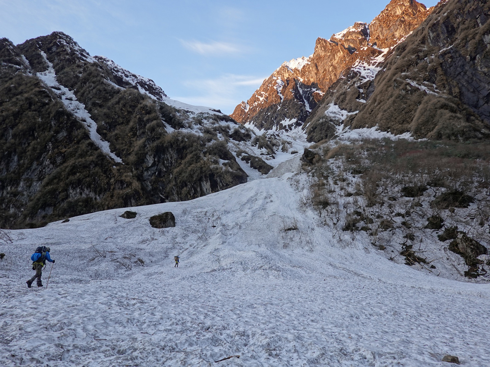
07 April. Sumba Lumba East Pass to Sumba Lumba West Pass. 2 km. 4 hours. 150m up. 100m down. After a night of heavy snow with nearly 25cm falling we were surprised to open the tent at 0600 to find a beautiful dawn. Ramesh was the first up as usual, and went outside to fire up the primus stove to melt snow and boil water for teas, breakfast and for the day. We all followed, with Dale and me being the last. They all had Tsampa for breakfast but I have never been able to like it so had a couple of packets of noodles. It was now obvious where the East Pass was, and it was just some 5-600 metres away and up slightly. We packed up slowly and did not set off until 0900, by which time clouds were beginning to obscure all the peaks in the Kanchenjunga massif, and indeed all those intervening ones, and mist was forming on the peaks around us.

048. Leaving our camp before West Pass Lumba Sumba and climbing to the pass with Kanchenjunga in the distance.
We set off through the deep new snow with Bharat in the front ploughing like a Canadian train. It only took some 20 minutes to reach the East Pass and Dale found the prayer flags buried under snow. By this time the weather had deteriorated sufficiently to obscure all the surrounding peaks and there were some snowflakes in the air. There was a brief discussion and Dale said he had to return from here as he had a long way to go back alone and was worried about conditions. He gave good instructions to the others in Nepali and I understood some, most through the gestures. He said we should reach the slightly higher West Pass in a hour at the most. I paid him and gave him a small tip. He then said his goodbyes to all and said he had really enjoyed the last three days company. Dale had had a very hard life in Olangchun Gola, including the suicide of his mother and a violent, now-estranged father, and although 23, was guided by Nima Chettin of Lhonak’s big hearted sister and husband Tashi.
We set off and went about half a km when the snow started falling heavily and the mist enveloped us. We pushed on gingerly as it was on a steeper slope we were traversing. At one point Bharat and Ramesh went on ahead to check out a rocky slope we had to pass. They were gone 29 minutes and Santos and I were getting cold and decided to follow them as we could see them. At that point the skies cleared for five minutes and Santos and I could see the West Pass but due to the spur Bharat and Ramesh could not. I made new steps to reach them with my rucksack and told them I had seen the pass and was going on. They returned to get their packs, and by the time they had reached the spur I had already reached the last section and could see the pass. I waited a good 20 minutes for them to arrive and was cold.
While they rested I set off to where I had seen the West Pass. First down a moraine ridge and then across and up a small valley to a large cairn. By now it was snowing very heavily, the wind was getting up and it was a near white out. I could not see them following me so returned on my steps and found them slowly following and sheltering behind a boulder. I explained where I had been and we returned across the small valley to the cairn. The wind in the small valley was much milder than elsewhere. When we got to the cairn we could not work anything out in the blizzard and whiteout. I saw a cornice nearby and threw a snowball to work out the slope. There was a two metre drop. We all had a quick discussion and thought it was best to return to the small valley two minutes back and set up the tent. As it was just midday we could see if it cleared.
We had the tent up in 10 minutes and all the foam mats laid out inside. It did not relent outside and it was pointless to leave the tent. To make matters more difficult the sun was warming the tent through the mist which must have been quite thin. By mid-afternoon we decided to abandon the chance of going over the East Pass and decided to stay put, firm up the tent pegs, and melt water. Inside the tent it was well above freezing but that soon changed after 1700, and by 1900 it was perhaps minus 10. We all got into our sleeping bags hoping the snow would ease so we did not have to clear the tent and hoping that the wind would not increase to gale or storm force. It was a cold night and I did not sleep so well but the others did.
08 April. Sumba Lumba West Pass to Thudam. 19 km. 6 hours. 60m up. 1570m down. I got up at about 0300 to go to the toilet and noticed how bitterly cold it was in the wind but also how I could see the stars. By 0600 I looked again and it was a perfect day. I mentioned it to Ramesh who was beside me, and he jumped up and got into gear getting the stove going. The others followed quickly. Everything was frozen solid and even the boot laces took some working to lace up on the boots, which were all frozen solid. We had quick tea and biscuits and then then packed up just as the sun hit the campsite. It did not help and was still minus 10 at least. It took 10 minutes to set off, plough down the easy cornice, which was more of a drift in the clear weather and reach the West Pass at 5160m. The wind was bitterly cold so there was just time for a few photos, hugs, then a quick descent down the west side.

049. On top of West Pass Lumba Sumba, about 5200m, with the valley down to Thudam behind. From left Ramesh, Bharat and Santos.
As soon as we were off the crest the wind eased and after just 10 minutes ploughing down through soft fresh snow on a firm base we were in a partial suntrap. We could not relax and admire the surroundings which were huge, with 6000m mountains surrounding us. Dale’s instructions for the descent were perfect, and we followed a series of small moraine ridges down for an hour until we reached a snow covered meadow or Kharka. My gaiters had long given up and I was dreading cold feet, but Santos fitted me out with a couple of plastic bags to put round my socks and inside my shoes and my feet were perfect, warm and dry. It was a very photogenic descent and I fell behind the others taking photos. We met at the Kharka for a bar of chocolate each and decided to carry on down through the soft dry snow on the hard base while the going was good. Memories of wading down through soft sugar snow in Nanga La just a week ago were still fresh.

050. Descending West Pass Lumba Sumba towards Thudam with Santos with his huge red bag at the rear.
We went on down in the sunshine across boulder fields, rhododendron groves and occasional meadows for another good hour all on firm snow until we reached another meadow at the confluence of two valleys just at the top of the juniper trees. It was at a place called Samne. The others had already started a fire and were starting to cook spaghetti. It was a lovely meadow, and at the lower end of it I could hear yak bells clunking as they munched on the emerging grass. Despite the huge effort Ramesh and Santos had already put in they were busy washing dishes, making tea, collecting firewood and cooking. It is quite remarkable how strong these two are. I noticed a couple of eagles, probably Golden Eagles, flying up and down the valley.
After lunch I set off first for the final 3-4 km descent to Thudam. I passed the herds of grazing yaks cautiously at the bottom of the meadow. There must have been about 50 of them and a very hardy looking Sherpa herdsman. After that I plunged into the flavoursome forest, full of smells and sounds. The river tumbled down beside me and the smell of resin from the various conifers filled the air. I passed a few more pastures as continued the descent on a now good path. After four nights camping on the snow, often in bitterly cold conditions above 4500m, it was a delight to be coming home to the forest again. Eventually I rounded ridge and far below lay some large pastures which I guessed were the pastures around Thudham.

051. Approaching Thudam which lies in a mountain meadow after 1700 metres descent.
About half an hour later I reached the remote Shangri-La of Thudam. It was more of a hamlet with about 30 houses than a village. I spoke to a few elderly people outside some of the first houses I came to, but realized they probably did not speak Nepali, but a Sherpa of Bhote language. The houses were much smaller than the large timber edifices of Ghunsa or Olangchun Gola but of a similar style, and they all had shingles for roofs. It was as if I had walked into a medieval hamlet. I noticed that nearly everybody here was also above 50. All the young must have emigrated to find work in the lowlands, Kathmandu or the Middle East.
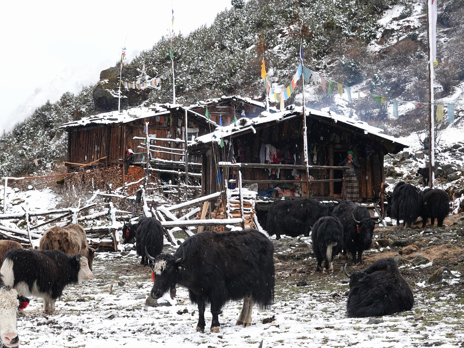
Thudam seemed to centre around Yak herding. Its 15 odd houses were all built on the north side of the large meadow at the confluence of two valleys. A stream from each valley merged to form a small river which flowed through the centre of the meadow. There were a couple of traditional stone and log cantilever bridges spanning the river, but the 200 or so yaks grazing just waded the river if they though the grass was greener on the other side. I gleaned that there were about six families who herded yaks here. After we washed clothes, thawed and dried the tent I had a snooze outside our homestay. I noticed then that a lot of yaks were being driven into groups by some of the residents. They were then all forced from the south pasture over to the north for the night. The bells, some brass, and it seemed some wooden, made quite a din as they all processed past me. Most seemed to be females, called nyaks, or calves.

052. The tiny and very very remote hamlet of Thudam consists of about 12 houses or families of which 5 earn their living from yak herding.
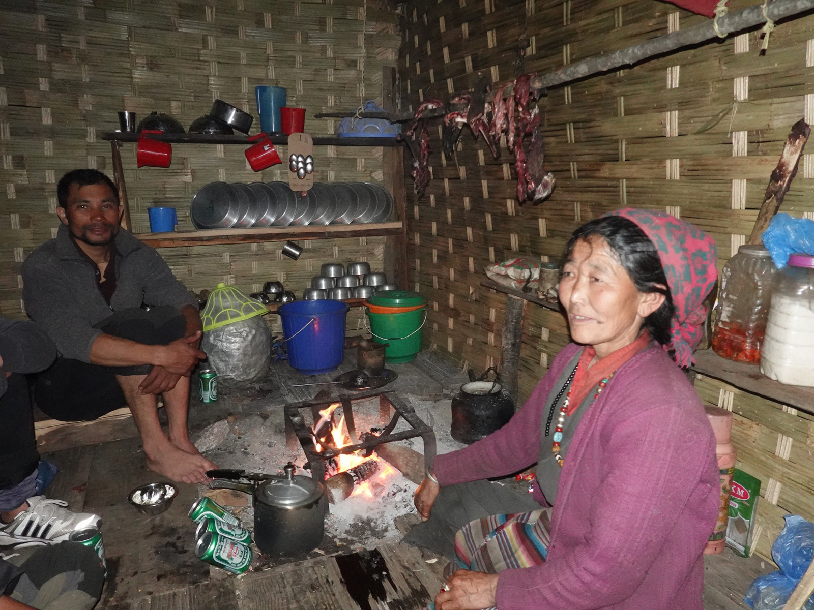
I went into the homestay when the sun lost its heating effect around 1600. It was just one room with a Sherpa lady running it with her four year old granddaughter. She had a rustic shop full of Chinese food. Indeed everything in Thudam was Chinese as the border was much easier to get to that the road end at Num in Nepal some five days away. Santos bought, killed, prepared, and cooked a chicken for the others who had worked hard for the last five days. I slept on the only bed while everyone else, including the host, slept around the fire in the Sherpa kitchen part of the room.
April 09. Thudam to Arun River. 22km 10hours. 850m up 2480m down. We were all surprised when we woke up to see Thudam covered in 5cm of snow. All the imperfections had been covered up and what showed were the rustic houses, the strings of prayer flays covering them and the yaks starting to cross the river. Smoke hung over the houses where it leaked out of their roofs from the dark kitchens inside. After breakfast we set off about 0800 by which time some of the snow was melting. We wove through the houses and the groups of small nyaks and yaks gathered around them, passively looking at us, and headed up the track. The boys were slightly ahead of me as I lingered to take photos.
054. Overnight there was about 5cm snow at Thudam. The yaks stayed close to or under the houses at night.
After about five minutes, as the track was passing through thorny scrub, I noticed a yak up ahead on the trail round a corner. A few seconds later it was round the corner, head down, charging towards me. It was a huge angry bull and while its half ton would have sent me flying, it was the horns which loomed large. If they touched me they would have punctured me, piercing a lung or disembowelling me. I instinctively leapt off the trail, down a 45 degree slope into the thorns, and landed on some stones losing my footing and crashing to the ground cutting my knee. As I lay there I heard the hooves of the beast thundering past on the rocky path as it headed down. It was a lucky escape. It took me a good 30 seconds to make sure the beast was gone and haul myself back onto the track, scratched and muddy. Bharat and Ramesh were rushing down the track to see my fate. The beast had come out of the scrub behind them but had charged at Santos who was coming up the track. He managed to evade it by leaping onto a rock like a matador as it charged past him to spot me. We were all a bit shaken.

055. A hillside of Himalayan Primroses which thrive around the 3000m mark.
After that incident all I could think about was the yak attack as we wondered down through mossy woods into a deepening valley for a good hour. The rhododendrons were now coming into full flower and I noticed that there were a lot of pink ones also on the trees, with larger leaves and a brown underside. There were also areas where the whole green mossy forest floor was covered in the purple primroses. It was drizzling a bit now which took the beauty off the place. After about 90 minutes we reached a junction and realized the lower track was just a herding track and we had to take the upper track to escape the upcoming gorge into which the tumbling stream was about to enter. It was a steep climb up the side of the valley for half an hour until we got to another junction. The upper way looked well used, but we concluded it went over to Tibet and all the litter seemed to indicate that. The lower path seemed to be the path we had to take according to the map, but it was small and barely used. We took the chance and followed it.
For the next two hours we followed this small precipitous path through a Tolkienesque landscape of rock towers, jagged ridges, deep gullies and huge buttresses through which the path wove. It could have been the home of a Taoist Monk in ancient China. I was enthralled by the landscape but the others found the convoluted ups and downs tiresome. Eventually after some two hours I at last spotted some prayer flags between two rock towers and knew we were soon at the top. When I reached it I saw a totally different landscape on the other side. It was more grazed and covered in bamboos and the primeval rhododendron and conifer forest was gone. You could even see villages the other side of where I assumed the Arun River to be. I waited for the others.

056. The mountainsides between Thudam and the Kharka reminded me of a Chinese watercolour of the mystical Celestial Mountains.
There was a Yak Kharka after the pass but it took a good two hours to get there as the path wove all over the hillside. Frequently we thought we were on the wrong path as it descended down to the gorge. After having us puzzled, it at last started heading west contouring across the hillside. There were frequent rivulets to cross and at each on the path dropped into the ravine and then climbed out of the ravine on the other side to reach the ridge to start the whole process again. The ravines were lush and verdant and fill with mossy hemlocks and bamboos. It was perfect Red Panda territory but we did not see any signs, just a large Yak who was reluctant to move off the steep trail. Given this morning’s incident we were reluctant to approach, and threw stones and shouted from a distance until it shuffled off into the undergrowth.
At last, after six hours without a break, we reached the Yak Kharka. It was a very simple bamboo shelter with a family staying there. They had about 50 yak/cow crosses called dhzo. There were young calves everywhere, and even as we chatted the son arrived carrying a new born with a concerned cow in hot pursuit. We went into their shelter for a much needed meal. I had noodles while the others had tsampa and hot fresh milk. I had a glass of milk too which was hot and sweet. We could have lingered here but we still had three hours to walk to the bhatti at the Arun river and it was already 1530. So we bought some dried milk products called Churpi, which a hard dry product about the size of a large ivory dice. When put in your mouth it takes a good five minutes to soften slightly and then becomes chewable for half an hour before finally becoming digestible.

057. After a quick break at this Kharka which herded dhzo, (half yak half cow) we continued our journey to the Arun Nadi River.
The final stage was long. We descended from the Yak Kharka to another unused one. On the way through the forest were passed groups of magnolia trees. High above the forest canopy these trees shone. On the forest floor large white petals rested on the mounds of green mossy. It was quite a sight, but the trees were difficult to photograph against the cloudy sky. In this area the Rhododendrons were also in flower giving the forest an enchanted atmosphere above the ever present bamboos. There was a 2-300 metre climb over the last ridge after the second and disused Yak Charka before we reached a crest and could begin the descent.
And what a descent it was. On top of the previous 1500m descent we had done we not started a straight 1000m steep descent all the way down to the Arun river. Initially I felt sprightly but as the zig-zags continued my legs started to feel wooden and I lost all interest in my surroundings or sounds of birds as they prepared for the night. Dusk was coming as we reached the final bends to the very long foot suspension bridge over the raging Arun River, which flows into Nepal from Tibet. Just after the bridge was a small bhatti where someone in the Yak Charka had phoned to say we were en route and to await us.

058. The huge Arun Nadi River rises in Tibet and flows south through the Himalayas in a deep valley.
I arrived at last light and was delighted with the place. Bharat and Ramesh were already there. It reminded me of some long gone jungle shanty from a colonial era. It was a spacious woven bamboo shelter with a plank floor and a fire in the corner. It was new as the fire had not blackened any of the roof yet. It was run by a 54 year old Sherpa lady and her somewhat vain spoilt son. She was a delight with an infectious smile and laugh. We were all tired and I could not write the blog. Instead I got two beers for everyone while Ramesh and Santos took over the kitchen and made the meal. The two beers each turned into four. We all then unrolled out bedding in a corner of the place next to the bamboo walls. We had now come down to 1900m and it felt warm down here, especially after our near 10 days in the snows. The one thing I thought as I fell asleep was just how remote Thudam was, as we had walked 10 hours and still not reached the next village.
059. The tiny bamboo “hotel” in a clearing just above the Arun Nadi river was run by this charming Sherpa lady. Ramesh has already taken over her kitchen!
10 April. Arun Nadi River to Hongon. 17km 7 hours. 1200m up. 730m down. I was far too tired to do any writing yesterday, so I got up at 0630 to write and then have breakfast. The guys were quite thankful of the slow morning and used the back hosepipe which ran down the sunny hillside to wash in warmish water. We eventually set off at about 0930 after saying goodbyes to the gentle happy Sherpa lady who hosted us.
Initially it was a steep climb up the hillside for 3-400 meters to reach the village of Chyamtang. As I climbed I noticed more and more of the Bhutan Pine was dominating the trees at this altitude. The village of Chyamtang did not enchant me, and it seemed everything here was perfunctory and nothing was in good repair. The main path through the village was soggy as a black plastic water pipe had ruptured and no one had repaired it. The school, sponsored by Austria, looked like it was permanently closed save for the volleyball pitch. I was ahead of the others so I made my own way through the village and up to a defunct road which was came down from China to reach out to these border villages. The road was blocked as various places by landslides.

060. The village of Chyamtang is the nearest neighbour to Thudam but is some 10 hours walk away. It has a character more familiar with the Hill Region, or Pahad.
As I walked the breeze got up and I could hear it flowing through the pines gently swishing like a Basho poem. I passed a couple of mani walls and small chortens and then followed the pines down to the village of Lingham. I cared for it less than Chyamtang which at least had a rural feel. Lingham on the other hand was something of a commercial hub with a couple of rustic hotels and a few shops selling simple wares. There were a lot of single men hanging around these shops and hotels and even at midday some were drinking. I saw one man, all his front teeth missing and one hand in a filthy bandage, staggering up the path already drunk on Raksi.
We had a meal here and then I escaped down the track to the nearly adjacent village of Chepwa. Chepwa was surrounded by green verdant fields of corn and potatoes. It looked like it had some rural charm but the fields were deserted and most houses were quiet. I did not go down into the centre but skirted round the top of it heading for a cluster of mani stones and chortens on the ridge. At the uppermost one the path split. With a smaller path heading up to pastures and just used by animals while the lower path seemed to be the main path to Hongon. I took it rounded a corner and got a sensational view of my route.

061. The path between Chyamtang and Hongon went along the north wall of the Arun Nadi gorge but about 500m above the river. You can just make the path out contouring across the very steep hillside.
It seemed to cling to the hillside and contour round a near vertical mountain for about 3-4 km. Far below was the roaring torrent of the Arun Nadi river in a very deep gorge. On the east side was an isolated village surrounded by valley after valley of near inaccessible prime jungle, where there were no paths and no one could venture. I started on the path across the very steep hillside. Although the Arun Nadi river was some 5-600 metres below me I felt if I threw a rock it might land in the river. I gingerly made my way down some very steep slopes until the path started to soften. At times there were even some trees between me and the precipitous slope. This made me more confident and I could walk with more abandon. These comfortable sections would be interspersed with more exposed sections where in Europe they would be secured with cables. It was a great walk with sensational views over the Arun Nadi valley towards the village of Hattiya.
At the end of this section was the small, desperately poor hamlet of Gimbar. Here it seemed a small herding community was just trying to establish itself on poor pastures on an isolated ridge. There were perhaps three or four families here on the margins of society. Perhaps these families were from Hongon and this was a summer pasture, if not it was a very poor community. I passed through and then started a long descent through forest and jungle to the river. This forest was full of birdsong and was a natural oasis in an otherwise pastoral world.
At the river there was a small wooden bridge before the long 300 metre climb up to Hongon which I had seen for the last two hours as I came along the sensational airy path. The climb was steep initially but as it climbed out of the forest and entered the first fields it eased. The fields below the village were alive with activity in the late afternoon. People were carrying baskets of organic fertilizer, carrying firewood, tilling fields with mattocks, or looking after small cattle. It was in total contrast to the commercial sloth of Lingham four hours earlier. As I approached the village hordes of lively confident children ran down to meet me without the usual request for sweets or pens. Even before I got to the village I liked it. Then suddenly I climbed a small knoll and it was there before me. Solid stone houses, most with corrugated iron roofs were spread out across a shelf. The houses were close together but were not crammed together and there were spacious lanes between them.
062. A warm welcome to the very friendly village of Hongon by some of the children. This large, charming, village had about 100 houses or families.
I was told Tengba Sherpa did homestays and asked for his place. When I arrived I found it was a simple rustic hotel with a shop underneath. It was called the Yangma Hotel. I was shown a simple room with old sheets and it suited me perfectly. They had a room for the others also. The host and his wife were very jolly and seemed to be having fun with Ramesh, Bharat and Santos who were a very sociable and easy going trio who put everyone at ease. The host was also the local teacher and in the other room were a couple of French volunteers who were working at the school for two weeks. We all gathered in the kitchen for the evening and it was an informative and social evening. There was also electricity here and so it was the last chance to top up the batteries before reaching the Everest region in about two weeks.
April 11. Hongon to Bakim Kharka. 8 km. 4 hours. 790m up. 90m down. After a superb stay at the Temba Sherpa’s lodge, where he and his wife entertained us with their wit and charm it was time to head on up. We just had a short day so we decided on a later start after eating the 1000am dalbhat. Nepalis generally just have a mug of tea for breakfast and then two Dalbhats a day – one around 1000 and one at 1900 in the evening. It is a simple healthy diet and a much revered national dish. We eventually left at 1100 in the hot sunshine. Again I noticed how busy everybody in Hongon was. School was off, so all the children were dispatched to collect pre-cut firewood in their baskets. They did this with good cheer despite it being almost an hour’s walk. In the fields everybody was busy weeding and repairing walls and fences. I walked with a couple of teenagers who wanted to practice their English on their way to get wood. When I asked them their caste, expecting them to say Sherpa they said Bhote. This surprised me as Bhote is also Tibetan type, but it is also used as an insult against the more Tibetan peoples who live in the mountains like the Sherpa.
We followed the very well-constructed pipeline taking water down to the small hydroplant which supplied the village with modest power. At the top the path headed off into the thick forest on a small and at times barely discernible path. It dropped down to a stream and crossed it before reaching another stream which it by and large followed for the next three hours. It went through dense moist forest with many rhododendrons, most in flower now, and also a band of magnolia trees around 2600m, which were all in full blossom in magnificent displays. The forest was really dominated though by some huge Hemlocks. These towered some 40 metres and a few had a bole diameter of more than two metres with at least one at three metres. I estimated this venerable old conifer to be at least 400 years old.
It was hard to follow the path in places, but it generally kept to the east bank of the stream as it slowly clawed its way up the green moist moss clad valley. There were mostly red rhododendrons in flower, the Laligras, or national flower, but there were also some pink ones with big leaves and rouge on the underside and another I had not seen before which were deep purple flowers and small almost round leaves. We reached a meadow with a great campspot but we knew there were three meadows and wanted the highest one. At the second one a group of porters came down the valley. Then even more, a couple of cooks, and finally a guide and four Belgians.
They had wanted to go to Molan Pokari but had been thwarted by the snow. This was not good news as there were 16 Nepalis and four Belgians and if the 20 of them could not force a path I thought what hope have we got. They blamed it on the thunderstorms 10 days ago and said many of the mountain areas of Nepal were badly affected, with the Government ordering people to come down. It all sounded a bit melodramatic and I hoped they were exaggerating. After all we had been coming over the Nanga La and Lumba Sumba passes during this time. The guide seemed to suggest we should turn back, but Bharat also seemed to think they had failed and so thought it was impossible for anyone else to succeed.
Just beyond our meeting with this group we came to the top meadow. It was small and riddled with boulders across its top half. None the less we managed to find a camp spot for the large tent. Bharat went off to start a campfire with we put the tent up and had it finished as Baharat’s fire got going. It did cloud over, but in the late afternoon it cleared up a bit and I could see the tracks of the Belgians and their entourage across a snowfield high up the valley side. It would be useful tomorrow but it only went half way.
Ramesh made a great dalbhat on then campfire as I retreated inside the tent to write. I am a little worried about the snow tomorrow as we must climb 1200 metres and descent 600 metres. It is my bad luck this had been such a snowy year and in my bid to beat most of the monsoon I started perhaps a month earlier than I should have done. But we have made it this far and the team is getting stronger.

063. The meadow in which we camped with rhododendron and Bhunia daphne. Beyond in the steep snowfield we had to climb to reach Molan Pokhari.
April 12. Bakim Kharka to Molan Pokari Pass. 8 km. 10 hours. 1170m up. 100m down. It was a great morning in the meadow, and the rhododendrons seemed to have blossomed more during the night. More importantly though the weather was good and I was keen to get going, so at 0530 I gave Ramesh as nudge. He was really my right hand-man; very dependable, always cheerful and a leader yet to find a role. We had breakfast and had the tent packed by 0700 and set off. I was keen to use the early morning firmness of the snow to follow the Belgian team’s footprints up the hillside as far as possible.
I set a good pace and the others were soon behind. The snow was firm and I was able to take steps with the nervous worry I would plunge through to my thigh. I followed their tracks up through the last of the forest at around 3400 and then onto a huge snowfield on the east side of the valley on a west facing ridge. Being west facing it did not get the early sun and I was delighted when their footprints stayed firm. I could see the others far below me but I was on a mission to reach the end of their footprints before the sun made them soft. The snowfield was quite steep in places and had the snow outside of the footprints been as hard as them then a slip without ice axe would have been serious as one would have crashed into rhododendron trees far below. At one stage their footprints crossed a shallow couloir which ended far down in the valley. I was slightly nervous crossing it and even more nervous for Santos who was far behind. If he lost his load it would slide and cartwheel into the depths of the valley we were climbing out of.
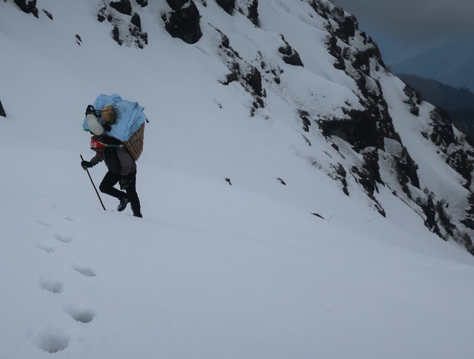
064. Ramesh climbing the steep snowfield with about 35kg in his basket. An awesome guy.
At about 3600m the inevitable happened and the footsteps stopped, as I knew they turned back. It was a shame for them as they had done the bulk of the climb and from here things eased off. I don’t think I would have been able to make it this far on my own without their footsteps. I now had to climb another 150 metres in the sugary snow on my own and it was very taxing. At last I reached a lip and the ground levelled off and I found a rock with some dryish vegetation on it and waited for the others. The great weather had gone and bands of mist swept up the valley obscuring nearly everything and then there was an interval when the sun returned and warmed my cold feet. After a good half hour the others arrived and we all agreed that was as steep as we would like it.
From my rock we all went up the final 100m to Molan Pokari lake. It was completely frozen over and the whole basin was covered in deep snow. It was a bit of a waste for us to see it in this winter state and I am sure in the summer it would be serene. There was a small slither of water where the stream left the lake and before it plunged over a waterfall into the valley we had just climbed out of, and there was a duck already there laying claim to its summer territory. I think it was a Brahmin Duck. We gingerly crossed a frozen part of the outflow and had another rest. The weather seemed stable despite clouds below us in the valleys to the south. I pointed out the pass only some 250 metres above us and we all decided to go for it and continue down the other side to Tin Pokari lakes.

065. The fabled lake at Molan Pokhari was completely lost in the winter landscape and frozen over. In the distance at the mountains on the Nepal-Tibet border.
Those 250 vertical metres across the snowy mountainside were very taxing. Again I led slowly, postholing my way up the snowfields of deep sugary snow which had been warmed by the sun. My progress was very slow and it was very laborious, but when I looked behind at Santos and Ramesh my heart bled for them as they struggled with their huge loads. They were so stoic in their determination to reach the pass. It took me about two hours to break a trail up the 250 meters over a long kilometre but at last having been up to my waist many times and up to my neck once I made the pass. When the other arrived I felt I had to apologise to them for putting them through this.
We descended some 50 metres on the other side and after 10 hours on the move I thought we had to camp. The descent from this pass involved just one more small climb before we could make the long descent past Tin Pokari lake, which would also be completely frozen, and then on down to Dhungee Kharka. It was after 1700 and it would soon be getting cold. There were some great views down the valley but we were too focused on getting the tent up to bother with them. While I crawled into my sleeping bag to write and warm up, Ramesh and Santos merely changed socks and then set about melting snow for tea and to cook the evening Dalbaht. There was no rest for them and without them I would have no hope of having completed what we had done. They were the real heroes of this trip.
April 13. Molan Pokari Pass to Dhungee Khola camp. 15 km. 7.5 hours. 160m up. 1190m down. The first thing we had to do today was climb a slight ridge to gain the valley with the Tin Pokari lakes. The weather was on our side although there had been thunderstorms nearby during the night and we had had about 5cm of new wet snow. Bharat led the small traverse and climb across and over the ridge and then seemed to hesitate on the huge downhill section coming up so I took over.I tried to keep to the slopes where I thought the sun would have least effect but it was impossible to link them all up and occasionally I was up to my waist. I thought of the poor porters. Despite the magnificent surroundings I was angry with this year’s snowfall and despondent about the task ahead even for the next four to five days to Yangri Kharka where we would meet Dawa. We just seemed to be wading or ploughing huge amounts of snow where there should be the odd snowfield and otherwise small paths. I was not enjoying it, and there just seemed to be no end in sight.
The descent down to Tin Pokhari was ok as I seemed to hit a seam where I only went in to my ankles as I ploughed down. The others seemed reluctant to follow, and I suspect Bharat was waiting to see how I got on. When I reached the lakes I did not stop but continued down the north side of the river on a ridge of firmer snow. As I reached the valley I veered away from and bushes or boulders which might mean softer snow. Before me was the large meadow of Dhungee Kharka, which was completely covered in snow. My descent fortuitously led to two simple log bridge over the infant Dhungee Khola stream. I continued down the snow covered meadow occasionally looking round to see the other following perhaps a km behind. At the bottom of the meadow were some grassy hummocks partially in the sun when it broke through the mist. I waited here for the others who arrived remarkably quickly.

066. Coming down from the highpoint near Molan Pokhari to Dhungee Kharka.
Below the snow covered meadows the route descended to the west of the stream. However it was all covered in snow as it weaved its way through rhododendrons and bamboo thickets. Somehow I managed to pick up the hidden path and followed it down for a good hour until the snow finally disappeared at around 3200m. Occasionally I took a wrong turn and had to back track just as the others reached the same fictitious junction. Because the path was so elevated in the snow the porters had real difficulty negotiating the tangle of boughs and branches which would otherwise be a metre or so above them. Once the snow had gone we picked up speed and enjoyed the utter wilderness of the valley into which very few venture.
I rounded a corner and started heading up the Kholakharka Khola on the rocky path. After half an hour I thought something was wrong as we were climbing. I though this tiny obscure rough path is leading us up the valley to a pass into Tibet. The others agreed and then Bharat and Ramesh volunteered to go on without the baggage to check it out. They came back 20 minutes later to say it was heading up the valley and not down to the stream. We must have missed the path down to the bridge on the map. Bugger! We had to back track for a good 20-30 minutes to where we assumed the other faint path might branch off.
After five minutes we all thought it might be just as easy to bushwhack down the steep hillside to the confluence of the Dhungee and Kholakharka streams, and hopefully we would intercept the path we missed. The bushwhack was arduous for me, and to make matters worse it was raining now. The hillside was steep, slippery and covered in a creeping weed which obscured boulders. I often used bamboos or rhododendron branches to stop myself falling. It was very difficult for me but poor Santos frequently got ensnared in the weed or slipped on the steep muddy slope and fell a total of five times. Even Ramesh was struggling, especially in the thickets where his basket frequently got caught. I made it to the confluence of the streams first and found no other path we missed. To my horror there was also no bridge over the stream. It would have been easy enough to wade but it would have been thigh deep and white water. I wandered upstream a bit and found a simple log someone had placed. Eventually the others followed me up and we all crossed.

067. Ramesh crossing the tiny bridge over the very remote Saldim Khola before we headed up the south side.
From the log we had to bushwhack again through wet rhododendrons hoping to find the path. It was already 1630 and we were all concerned we might not find a camp spot. At last I spotted a path coming down the valley and pushed through the scrub to it. We all let out yelps of delight when we came upon it. Following it down for about 15 minutes we emerged from the silver fir and scrub forest onto a small meadow which had a great campspot. As usual now Ramesh and I put the tent up while Bharat and Santos went off to start a campfire to dry some clothes on and cook on. We were all wet, muddy and miserable but somehow the porters kept up their good spirits. Tomorrow should be a short day to a cave camp but after that we have another three difficult snowy days around the 4000m mark. It is imperative we do this otherwise we might be trapped as I don’t think it is possible to follow the river down and the only other way out is back the way we came via Molan Pokhari. I told Ramesh the cook and quarter master we might need another five days of food and he looked concerned! This section is turning out to be an extreme boot camp.

068. Whenever we camp in the woods we make a camp fire to cook on and to dry out some clothing.
April 14. Dhungee Khola Camp to Sedim Khola Cave Camp 5km. 4 hours. 400m up. 300m down. It seemed another nice morning but we only had some 5km to go until we reached the the so called cave camp in Sedim Khola at the bottom of a 1100m couloir. The guys lit the fire again at the bottom of the meadow to make breakfast. The whole meadow seemed to have been ravaged by wild pigs. This was an extremely remote area and I am sure they seldom had to worry about humans. We set off about 0800 and followed the small path down the west side of the Dhungee Khola stream.
After about a km we suddenly reached a large and quite new bridge crossing to the east side. It was not marked on the map. I was quite sure we should not cross it but Bharat and Ramesh went off to investigate and returned saying there was a small path. In the meantime I investigated the path heading south down the west side, as the map indicted and it seemed to be ok. There was a bit of a discussion about which path to take, but as I was the only one who understood the map I prevailed. It was a total mystery where the other path went as this whole area on the map was pathless. I concluded it must go over the mountain to Hattiya, a two day (or in these snowy conditions a four day) walk away. It was possibly our escape route if the Pass from Sedim Khola was too steep or dangerous.
We continued down the Dhungee Khola for another 2km, climbing slightly through the fir, hemlock and rhododendron and then descending steeply to Sedim Khola. There was the remains of an old meadow here but it seemed the jungle was taking over again. I wondered just where people came from to bring their animals here for the summer as I cannot stress how remote it was. Just below this meadow the path met the Sedim Khola stream and crossed it on the smallest most rickety bridge which would take 100kg, which was perhaps built by the seasonal herder for his goats.
We stopped here and again Bharat and Ramesh went off to explore the path even after I told them it was in the opposite direction and we needed to go upstream. I am sure this path would have been summer herding track as the map indicated that the Sedim Khola descended into a deep gorge for some 30 km until it joined the Barun Nadi river which was also in a gorge. If in the remarkable circumstance there was a bridge over the Barun Nadi river we might be OK, otherwise we would be would be trapped after our arduous two to three day bushwhack. Our only way out was over a pass which started 2km upstream and which I had seen yesterday. From the foreshortened view it looked steep and covered in snow and I was full of dread.
We found the path up the south side of the Sedim Khola as it emerged from avalanche debris and followed its faint route up. After a km we lost it as it was frequently buried by snow. I could see the chute at the bottom of the pass about a km ahead and it was completely filled with avalanche debris. There must have been multiple avalanches down here over the last two to three months and it spilled out into a huge fan almost a km across. I was keen to look up the chute so we climbed up the hard compacted snow of the east side of the fan for at least half a km until we could look up. It was not as steep as I feared and I reckoned we could do it in a morning as long as the weather was OK. It was a 1159m climb in all.
However there was nowhere to camp here and the small cave could only sleep two in discomfort. Ramesh wanted to continue up and get to the top and camp at Kalo Pokhari but I thought it was far too late in the day. I spotted a small meadow just 100 vertical meters below on the edge of the avalanche debris and we set off for that. It only took ten minutes to get there on the hard snow which flowed right across the Sedim Khola. The meadow was a bit damp but we had no choice. The tent was up quickly and Bharat got a camp fire going.
Just as we got settled round the fire it started to rain and soon it was bucketing down. This was not the sun filled afternoon to dry the tent and make our damp claggy sleeping bags crisp which I had been hoping for. I was beginning to hate this section. I slept while the rain poured. The other played cards in the tent and told me there were frequent avalanches in the valley during the rain shower. It was a very deep valley with large 4-5000 metre mountains on each side so I could easily imagine snow avalanching from high peaks and descending on the clogged avalanche routes. It was imperative for us to have good weather for us to ascend the pass to Kalo Pokhari. From there it would be at least another night in the snow at 4200-4500 metres. It would be a difficult three days. I also felt some sort of responsibility for the others as I had led them into this predicament, which I am not sure if they fully grasp.
April 15. Sedim Khola Cave Camp to Top of Chute. 5 km. 4.5 hours. 880m up. 20m down. It was imperative we got an early start so I set my alarm for 0300. Bharat got up and got the fire going and the ever reliable Ramesh and Santos followed leaving me to empty the tent while they cooked what has become known as Sherpa stew; namely rice, lentils and anything else, in this case chunks of ginger and the last potato. We ate round the roaring fire in the dark under the stars until the first light erased all but the brightest. It was light enough to walk by 0500 but we did not set off until 0530.
Our task was not an enviable one. We had to ascend some 1200m without respite, mostly up a steep couloir. We were blessed with good crisp weather and a slight frost. We had two pairs of microspikes, and I suggested Ramesh and Santos put them on as the first 500 metres of the chute was compacted avalanche debris and very firm and with the frost it was hard. They immediately felt comfortable and left Bharat and myself behind struggling for grip. I found it easiest to follow Ramesh as he disturbed the glassy surface. Eventually the surface softened slightly and Bharat and myself could take the lead and kick steps for the porters. It took nearly two hours to climb the first 500 metres and reach the top of the chute clogged with avalanche debris. We then had to climb a small steep section to gain the upper part of the chute which was not so ravaged by avalanches coming down from steep gullies to our west.
069. Heading up the huge gully to the east end of Furling Danda ridge. The gully was clogged with avalanche debris making for a firm surface which was easy to climb.
The upper chute was basked in sunshine which was a blessing to be in, but a curse as it was softening the snow. It was always ankle deep now and sometimes even knee deep. I led the way which was hot and exhausting while the others held back. I could forgive the porters with their heaving loads but Bharat was asked to take over for a while, which became the rest of the climb as I could just not keep breaking trail. The upper chute had another climb in it and then opened up in an almost flat fan perhaps a km across and covered in blue sheep tracks I think. The views to the north were stunning and we could see right up to Dhungee Kharka and Tin Pokhari where we were a few days ago. The valley we just climbed from, The Sedim Khola, was filling with mist, but the mountain tops on the far side were proud of it.
I was concerned that the weather was playing its usual trick by being fantastic for the first three to four hours and then slowly misting over and deteriorating until there was snow in the afternoon and evening. So Bharat and I rushed to a pass at the top of the fan to see where the next and final climb was before the small descent to Kalo Pokhari at 4200m. Out of breath and with my thighs bursting, we just made it up in time to see what we thought was the next section disappearing in the mist. With the 1:100,000 Nepali map, never known for its accuracy, and a cirque of jagged mountains before us, we needed sight of where we were going in the soft taxing snow. We waited for a good half hour but realized the weather was now deteriorating for the day so we went down to a flat area and pitched the tent even though it was just 1100. The mist enveloped all in a white out and we all thought there would be no let up so I got my sleeping bag out and had a snooze while the other three played cards. I was woken by rain on the tent. There was no let up until about 1700 when the mist cleared and revealed our pass but it was too late by then.
If this weather pattern continues we will still have three days to reach Yangri Kharka where Dawa is waiting for us. There is a teahouse there and it is becoming the promised land. Just two more high altitude nights, frozen shoes in the morning and 3am starts to go before we are out of our claggy tent and into relative luxury. We will arrive like bedraggled refugees
April 16. Top of Chute Camp to half way between Kalo Pokhari and Kharka canp. 5 kn. 6.5 hours 560m up. 260m down. It was another 0300 start to try and catch the best of the weather and the firmer snow before the sun softened it. It was desperately hard to put on wet socks and frozen shoes and then grapple with the frozen tent. We eventually set off at 0500, and this time I put Bharat into the lead by telling him I was just not powerful enough to make steps today. We climbed slowly but surely up for about 200m when we stopped for a rest. Bharat was tired after a difficult spell and I took over for the last half km to the pass over to Kalo Pokhri. There were some fantastic views down the valley and even down the steep slope we had just ascended.
True to form the mist already started forming at 0800 and the sun was had already softened the snow in the east facing slopes as we climbed out of the impressive cirque of towers. The descent to Kalo Pokhari lake was generally firm but I frequently went through the crust into sugar snow underneath and bashed my shins on the hard 3cm of crust. By the time I got to the bottom of the easy gully I was into soft sugar snow again and frequently up to my knees. Kalo Pokhari lake was a typical glacial cirque lake lying at the bottom of a deep bowl surrounded by jagged spires some 500m above it. Between the spires were the start of long snowfields which fanned out until they reached the lake, which was completely frozen.

071. A steeper section on the snow chute where a ridge of moraine cut across the main gully made for a tricky section which Santos and his huge pack gallantly led.
The weather did not deteriorate much after the early mists and it was only 0800. Yet despite this the snow was soft now. I would have been ok camping but the other were keen to move on given our food situation. I again told Bharat he would have to lead as I was just not up for it. What followed was a three hour struggle through some 2km of wet soft snow where we only climbed some 200 metre in all. Bharat was tireless in his efforts and postholed constantly to his shins and I followed usually adding some 15cm to his footsteps. Our feet were soaked as no cheap Chinese gaiter could keep that amount of wet sugary snow out. We all had plastic bags over our socks and in our shoes but the sock quickly got wet and our feet were freezing.

073. In the top half of the snow chute where it opened up into a fan leading to the penultimate pass of the climb which is all we managed before the mist arrived.
We saw some prayer flags on the shallow ridge ahead and went over to investigate them. There was a pass which went down from here but it looked extremely steep and convex just to add to the foreboding. It descended a good 150 metres. We all thought it too steep to descend safely. The map showed we should have climbed just a tad higher and then slowly descended on gentler slopes into the valley higher up where it came up. Just as we were debating what to do the mist descended and obscured all in a near white out. With our cold feet, huge effort already today and the confusing mist we decided to camp even though it was just midday. We all knew the weather was not going to improve until the evening.
We had the tent set up quickly on a level patch of snow. Then the matrasses were unfolded and we all dived in to change into our diminishing supply of dry socks. We all then climbed into our sleeping bags to try and warm out feet up, except Santos who grappled with the stove to melt some snow and boil water for soup. The rest of the day was now familiar with me snoozing and the others playing cards until it was time to cook supper around 1600. We were all done by 1800 and crawled into our sleeping bags for the 0300 alarm. This will hopefully be our last night of camping in the snow but we still have to find out way down to the valley and then climb up an over a 300m ridge before we can begin out descent from these difficult mountains where we have seen no sign of anyone else for about a week in this remote snowy wilderness.

074. Our camp just after the penultimate pass. We had to camp here around midday when mist enveloped us and confused us.
April 17. 1/2 Kalo Pokhari to Kharka to Ridge east of Kharka. 6 km. 7 hours. 530m ascent. 470m descent. There were loud thunderstorms throughout the late evening and early night and the tent lit up with a flash every 10 seconds or so. Most were south of the Barun Nadi river but some were quite close. They dumped about 5cm of sleety snow which later froze. Then the temperature dropped to about minus five and everything froze. At the 0300 alarm the tent was covered in frozen sleet. We were up and running by 0500 but as soon as the light came the stars disappeared and the mist arrived. We climbed back up to the top of the very steep gully which I was sure was too steep for us to descend and no one was very keen on the idea.

075. Leaving camp at 0500 in the morning to gain the top of the snow chute pass, our first of 3 in the Furling Danda range. Behind us the mountains of Eastern Nepal are spread out all the way to Kanchenjunga in the distance.
I convinced myself and the others that it was not the pass we were looking for but a lower one which went a different way, despite the small chorton and the prayer flags at the top of it. According to the map and my altitude meter the pass we wanted was just up the mountainside a little and there we would find a rake or sloping shelf to lead us down the craggy steep valley side to the floor. So we set off to find it. The mist was all encompassing and it was difficult to see, but with Bharat in the lead occasionally throwing snowballs to see the lie of the land we slowly progressed up the hill. We became very confused in the white out and nearly put the tent up but then the mist cleared and we could see where we were. And that was still on top of the crags which formed the side of the valley. We persevered in the wet snow, our feet getting cold, but we could just not find the rake to lead us down. Eventually Bharat and myself went on to where I was convinced it was (but we were 100m too high by now) to find another disappointment. I had to admit it my altimeter and map reading deceived me and now it was obvious the steep gully with the prayer flags was the way. It did not take us long to descend but there was tension in the air as we had wasted the best part of three hours on my excursion and needlessly climbed and descended some 150 metres.
On reaching the top of the steep gully I volunteered to go first but Bharat and Ramesh insisted they check it out without their baggage. They got to the top of the convex section and saw it was a straight run down to a fan of snow some 200m below. The warmth of the day was however melting some of the new snow from last night and this was occasionally flowing down the gully in small avalanches. Underneath the old snow was soft and sugary. As they returned to come back up I started my descent and it seemed quite secure in their steps. We exchanged words as we passed and I carried on keeping to the side to be out of the way of any larger avalanche should it surprise me. I reckoned the gradient of the gully was about 40 degrees and it was 200 meters in height. At last I reached the fan at the bottom and veered north so as not to lose too much height as we had to climb up the other side. Relieved, I rested on a rock and watch the others emerge from the bottom of the gully and onto the fan.

076. The last part of the climb at the top of the snow chute leading to the pass over to Kalo Pokhari.
We had a few glimpses of the other side as we descended and it involved a 3-400m climb up to a shallow ill-defined pass. We knew all would be on rotten snow and to compound it the mist returned. With Bharat in the lead we followed in his footsteps. However I nearly always went deeper and occasionally up to my waist. It was exhausting work for all of us especially the porters. We again got confused in the whiteout and knowing it was not going to clear and afford us a view we decided not to flounder about any more with wet feet and call it a day. The trouble was there were no flat tent sites so we had to spend half an hour excavating a flat site from the hillside using the dinner plates as shovels. Once the site was level we all crawled in to warm up as the snow started to fall heavily. I snoozed to try and warm my feet up while the others crawled into their bags and played cards. Santos seemed to be on dinner duty and had to go out into the snow showers and cook spaghetti on the large kerosene stove. As he did there were frequent thunderclaps. It was a very frustrating day in these wild remote mountains north of the Barun Nadi river which seem to attract poor weather. Our last week has really been a miserable winter mountaineering expedition but without the benefits of good boots and gaiters to keep the snow out. Everybody has been fantastic but morale is now low and we need a break.

078. Our last of 3 campsites on the difficult Furling Danda ridge. We could not find a flat spot so had to dig a shelf out of the slope with our metal dinner plates.
April 18. Ridge east of Kharka to Yangri Kharka. 15km. 8.5hours. 410m up. 1180m down. There were again frequent thunderstorms in the night and some 10cm of new snow, but it was relatively warm in the night and it did not really start to freeze until the early morning by which time it was misty. Indeed the mist did not clear until 0500 and this prompted speedy activity in the tent to the extent I got slightly left behind putting on my cold damp socks, covering them in plastic bags and then putting on frozen shoes. We set off at 0630 and it was perfectly obvious which way to go now, and my excursion up the hill yesterday to find this pass, just before we abandoned everything and put the tent up, was hopelessly flawed. My second mistake of yesterday.
All we had to do now was traverse the ridge for about a km heading south and we would naturally come to the pass. The sun had long risen as we made our way along the ridge with Bharat leading the way. The snow was soft as it had been insulated by the morning’s frost by the 5cm of new snow which had fallen. As a result we frequently went through but in the sunshine and with the pass fast approaching it made it more bearable, especially with great views to the east of this gnarly little ridge we had just traversed, and beyond that a sea of peaks stretching east culminating in Kanchenjunga and Jannu rising above all in the distance.

081. The joy of reaching the last pass was shared. It had been a hard 4 days to end a gruelling week since the comforts of Hongon. In the distance is the Khongma La pass on the Makalu Base Camp route.
At the pass there was a marked change in the mood of the team. The tension which had been building suddenly vanished and was replaced by euphoria as it was virtually all downhill now to Yangri Kharka. We had been out camping in the snow for eight days now and were all looking forward to a dry sleeping bag and dry feet. To cap it all there was a small view of Makalu, the 8500 metre mountain which would dominate our views for the next few days. We had a joyous photo session at the pass before starting the 500m descent to the snow-filled meadow in the valley on the west of the ridge. It was not as simple as we hoped, as the last 200m of descent were through soft snow with rhododendron scrub and we were frequently up to our waists in wet snow with our feet tangled in branches. At last we got to the stream on the valley floor, crossed it, and then started a difficult short climb through snow to a clearing where we had seen some signs of a snow covered path.

082. The steep gully we came down yesterday which was essentially the second pass in the Furling Danda range. Viewed from the third pass before the long descent to the Barun Nadi river.
Across the deep valley to the south were the snow covered ranges of the Khongma La series of passes which trekkers and expeditions to Makalu Base Camp had to cross. It was an area notorious for poor weather. In the valley was the Barun Nadi river in a deep gorge surrounded by huge cliffs and steep slopes covered in scrub. It was into this valley we now descended, but as we were on the south facing slopes the vegetation was much richer than the bleak scrub opposite. The rhododendron suddenly changed variety to the taller large leaved variety and then there were the first of the Silver Firs at around 3800m. Before long we were in the forest. The homecoming was fantastic. The smell of resins and birdsong filled the air as the big venerable trees enveloped us. There was even some warmth in the glades but much of the ground was covered in hard snow patches with icy fringes. I saw a couple of Himalayan Monals and many Blood Pheasants and other grouse type birds. They would all be very unfamiliar with humans in this remote corner of the Arun Nadi River drainage basin. The further we descended the more we left winter behind and entered a warm spring world with carpets of the purple primroses and flowering bushes of red rhododendrons. We plummeted down the spur with the air getting warmer as the roar of the Burun Nadi river got louder until we found a small glade with a small stream and a abundance of firewood and stopped here for lunch, eating the last of our food. It now became obvious we would easily reach Yangri Kharka today.
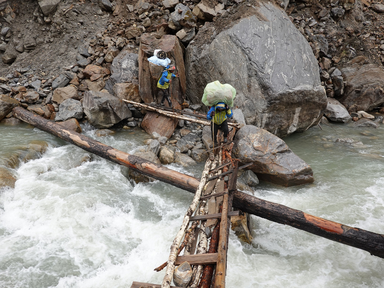
083. The rickety bridge over the Barun Nadi river took a steady nerve to cross. Here is the brave Santos having his go.
After lunch we had to walk along the tiny, tortious, and sometimes dangerous, path on the north side of the Barun Nadi River while looking across to the well-constructed path on the south side which was the main Makalu Base Camp path. We had to skirt plenty of landslide areas until after about 3km I spotted a ramshackle bridge over the torrent. It was very difficult getting to the bridge due to landslides and erosion but eventually I stood before it. It was extremely rickety and I was not sure I trusted it all at all. I went first and it seemed to hold. Bharat followed in a very cautious manner. Then Santos charged over with his huge load knocking one of the few logs into the water, much to the consternation of Ramesh who came last. There was another celebration as we now were on a major path up to Makalu Base Camp.
We immediately passed a teahouse run but a very charismatic Sherpa lady, and went in for a cup of tea. She was the first person we had seen since the Belgian group some eight days ago. She told us the ridge we had traversed along was called the Furling Danda. She also told us Dawa, our climbing Sherpa for the next high passes section, had been there this morning to try and contact Baharat’s office. He had been waiting for us Yangri Kharka now for four days while we have been stuck in the snow on Furling Danda.
The final kilometres to Yangri Kharka were glorious. The path crossed back to the north side in less than a km making our perilous bridge crossing somewhat unnecessary. For the next three to four km it wove a route beside the river across grassy meadows and sandy flats where a huge flood some three years ago had brought much silt down the valley and eroded the course of the river and destroyed the old path on the south side. I chatted with Bharat as we sauntered along here through the silver firs with the steam rising from a short rain shower. Huge mountains rose up 3000 metres on each side of us with Tu Tse (Peak 6) soaring what seemed almost vertically on our SW to a glacier covered crest above the clouds.

084. The final steps across the meadows on the valley floor before reaching Yangri Kharka, which for us had become a promised land. Dawawas waiting here for us to take us over the high passes in the next section namely; Section 04. Makalu.
At last we reached Yangri Kharka and there was a warm welcome from Dawa who was much relieved to see us. He had arrived four days earlier with two porters and all the climbing gear and some additional gear for each of us. He had brought my gaiters which I sorely missed in the last week along with my climbing boots, crampons, 200m of rope, snow anchors, harnesses, helmets and more. Our team of four had now become a team of seven for the next three weeks. There were some lively and joyous conversations over the next half hour before I went off to my simple room made of corrugated iron while the others caught up with each other. The next day would be a rest day to allow us to get cleaned up and dried off and to get acquainted with the climbing gear. Although Ramesh had been over Sherpani Col before, Santos and Bharat had hardly had a harness on.
Yangri Kharka was pretty much the end of the Arun Nadi section as although were still in its drainage area, the high passes south of Makalu, namely Sherpani Col, West Col and Amphu Labsta deserve a section of its own. The Arun Nadi section had been testing for us. Firstly the Lumba Sumba Pass to enter the section had been taken us longer than expected due to poor weather mostly affecting visibility and making us camp two nights at 5000m. After this, the section was varied and wonderful – especially the remote village of Thudam and mystical journey to the Arun Nadi River. Thereafter the villages to Hongon were lovely, but after that it became very taxing from Molan Pokhari all the way to Yangri Kharka. In retrospect it would have been so much easier to go from Hongon to Hattiya and then up the south side of the Barun Nadi river to Yangri Kharka, but that is not the route in the spirit of the Ghreat Himalaya Trail which is to endeavour to go the highest route possible. But given the winter conditions of the Molan Pokhari to Yangri Kharka due to the extreme snowfall this spring and the fact that this section attracts misty conditions as damp air travels up the Arun valley and condenses on these mountains, it would have been better to do the lower level alternative via Hattiya. The higher section we did should certainly be considered if there is a low snowfall year for a spring crossing, and especially if a post monsoon start to the Great Himalaya Trail is done. But for our trip with an early start in a very snowy year I am glad to see the back of it.
Section 02. Arun Nadi River. 127 km. 79 hours. 7160m up. 8490m down.