Section 12. Upper Dolpo
June 25. Ringmo to Phoksumdo Khola delta. 9km. 3.,5 hours. 600m up. 630m down. I had a great sleep at the Himalayan hotel and also managed to charge everything. The hostess was local and extremely helpful. Her husband was away and he was the elected headman of the village. I learnt from our host that Sitar’s wife, Lesung, had not in fact died but was away with her husband picking yarsagumba. I also learnt that it was his younger brother Urken who now stayed in the house. It was very confusing and all was made worse by translation. I checked the house again but it was still locked.
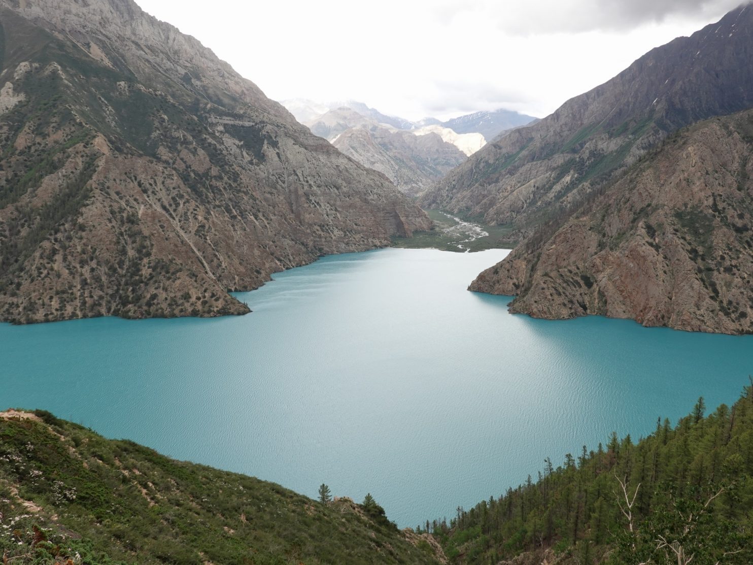
I wanted to visit the monastery, and Dawa and Santos wanted to come with me. We walked up to the outlet of the lake and crossed an old cantilever bridge over the large river. Then we wandered through pines along the edge of the lake past some chortens. We got frequent views of the monastery on the way, sitting on a small promontory above the turquoise waters in the sunny juniper and pine forest. It was the most serene setting for a monastery I have seen although the monastery was modest. The Lama, the spiritual leader, was there and he showed us around the main gomba. It was a brief tour and nothing like the extensive tour Sitar had given me 12 years ago. The Lama smelt of raksi and looked a bit scruffy and unshaven. Dawa, who was a Buddhist, thought he was a bit unprofessional. It was still a great visit and the Lama did redeem himself by showing us the prayer wheel he had made which stood two metres high. We ambled through the warm dusty pines back to the village enthralled by the monasteries location and the splendour of the whole area.

367. The outflow of Phoksumdo lake on the way to visit the Bonpo monastery on the edge of the lake about a km from the village.
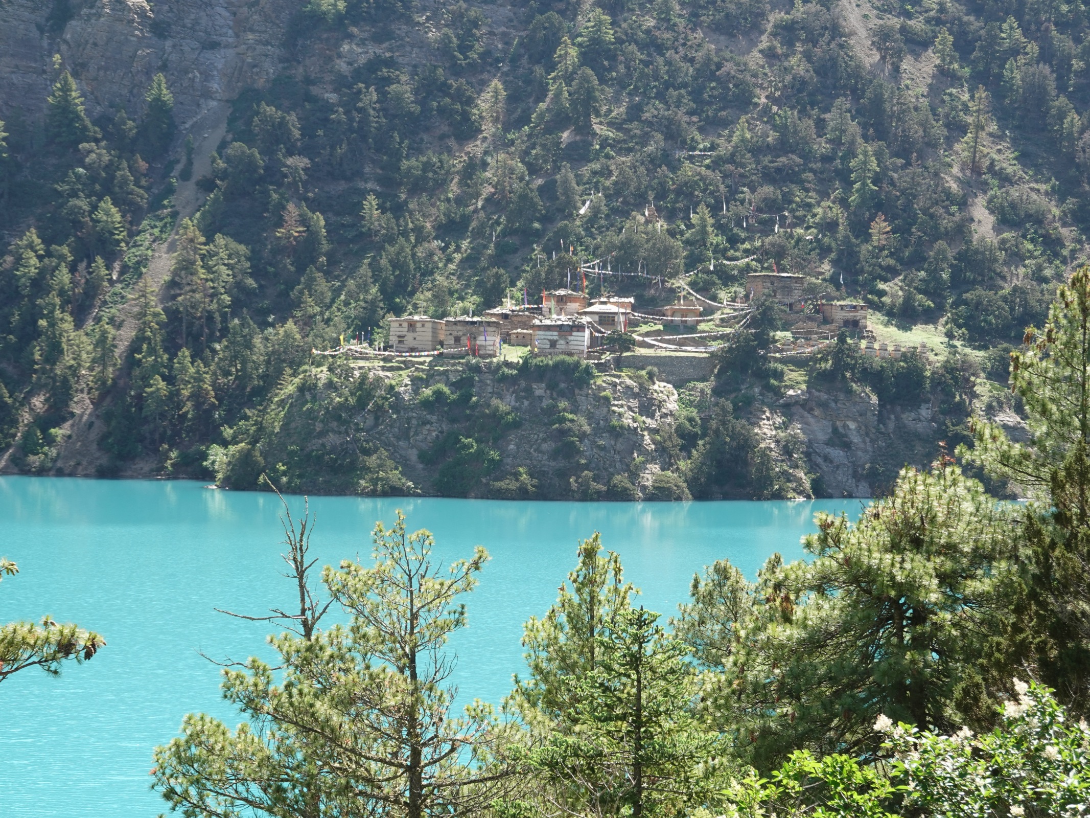
368. The absolutely perfect setting for the Bonpo monastery on the edge of the turquoise waters of Phoksumdo lake.

369. Chatting with the Lama of the monastery beside Phoksumdo lake near the village of Ringmo
On the way back to the hotel I spied another tourist, camping at the side of the lake. He was a grizzly Australian called Brian. We got chatting and suddenly I realized he was on the World Expeditions Great Himalaya Trail trip. He started about two weeks before us and we had been slowly catching them. He started with two others but one pulled out before they started, increasing his fee, and the other after three weeks. Brian however had survived. The World Expeditions Trip is annual and costs about US$25000-30000. It is a slightly more cumbersome style of expedition with a mess tent, tables and chairs, even a toilet tent. There were anything between 12 and 17 porters so Brian was treated like a king. The porters looked a bit like refugees when I passed them sitting in a shelter playing cards and smoking cigarettes. His group had followed the whole Great Himalaya Trail thus far but now seemed to deviate and follow an easier route to Hilsa via Jumla. I could have chatted to Brian for days but I had to get back to Bharat and Ramesh for an early lunch.
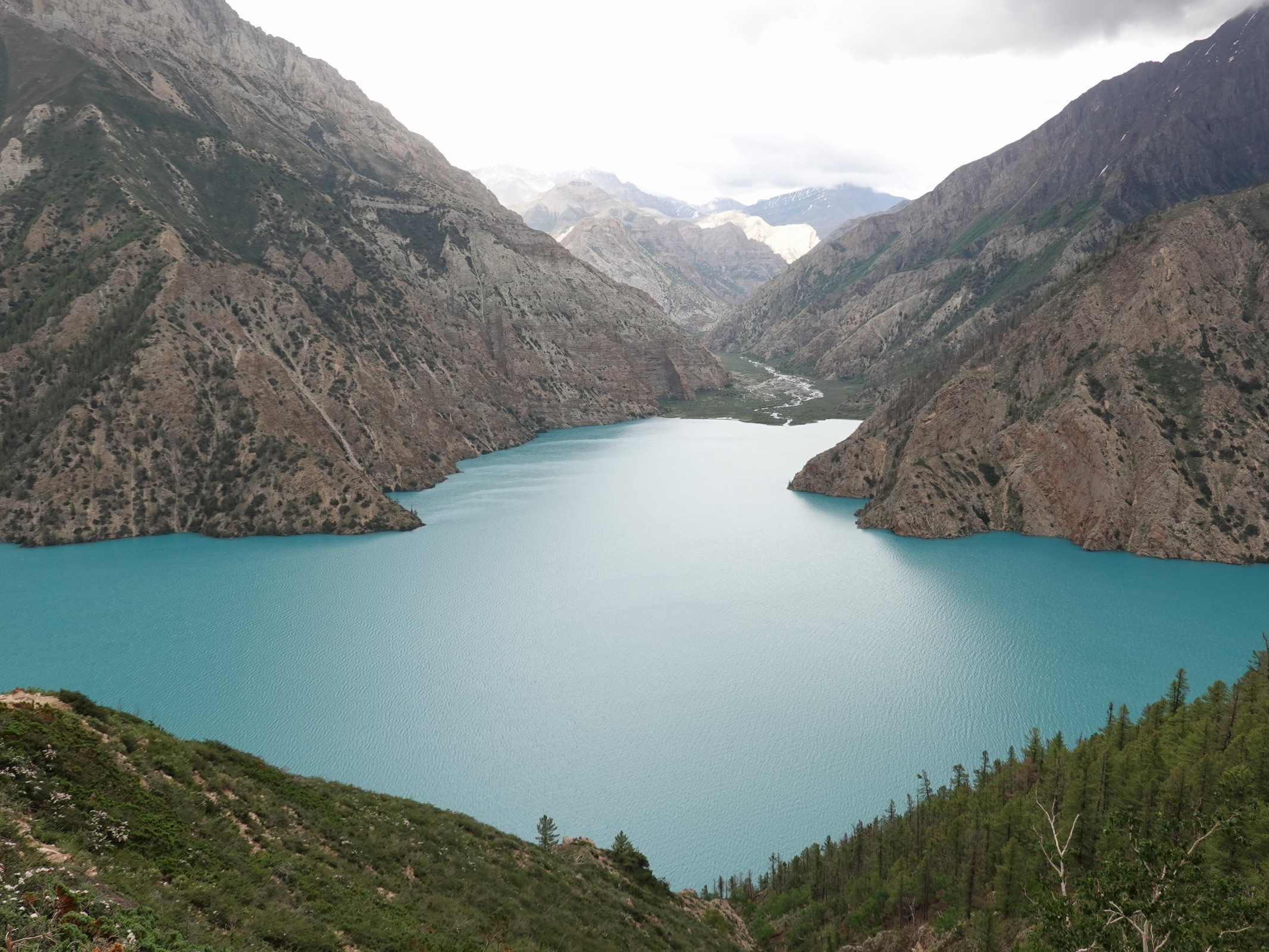
After paying the local hostess for the hotel, and chatting again with Brian, who seemed equally hungry to speak fluent English to another tourist, we set off at 1330 for the other end of the lake. I was eager to do this walk made infamous by a film called Caravan by Eric Vialli. The path followed an airy route high above the lake with a few very exposed sections.
It was indeed as airy as the film. At one point wood had been driven into rock cracks and the path built on it. If you fell you might drop 40-50 metres straight into the lake, as the yak did in the film. Across the turquoisest of waters was the monastery on the other side and up the lake the mountains rose very steeply for a good thousand metres. The path eventually dropped to a bay where a stream descended a side valley filled with Bhutan Pines.

370. Bharat walking on a bit of the path leading north from Ringmo village. This bit of the path is on a sheer face and is spanned by logs. It is the pace where Thinley’s yak plunges into the water in the film caravan.

371. Looking back to the precarious bit of path along the edge of Phoksumdo where Thinley’s yak plunged into the water in the film Carvan by Eric Vialli

372. Ramesh doing his Malla King impersonation above Phoksumdo lake. At the far end of the lake is the village of Ringmo. The Bonpo Gompa is off to the distant left in a bay.
373. The rarely visited and pathless NE arm of Phoksumdo Lake. The Lake has three arms, hence the Tibetan name.
From here the path had to climb steeply over a spur. The climb was about 400 metres and took a good hour. En route we passed a few groups of yarsagumba pickers returning home. Most were disappointed with their haul and some had not even picked enough to cover the cost of their permit. A lot of them were from Jarjakot district and a few from Jumla. Some of the groups had three to five mules carrying all their gear.
As we climbed the views became sensational, especially south to the end of the lake where the village of Ringmo lay on a small rise. Without doubt this is one of the best views in Nepal. I was so glad I chose this route option through Dolpo as Dho Tarap and Ringmo with Phoksumdo Lake are surely the jewels and there is Shey Gomba on this route option to come also. The northern route through Saldang surely cannot match this. There were many photos taken on the way up and everybody was spellbound. Moral was very high and I was euphotic with the views, the alpines and pines, and also the company.
The descent from the high spur was quite airy and we got great views across the lake to the mountains we crossed over the previous two days. The north east fork of the lake was where the river which drained these mountains lay below us virtually inaccessible. It was covered in birch and pine. As we descended we went through bands of Bhutan Pine or Himalayan Birch with their large leaves and papery flaking white bark. The vegetation depended very much on the aspect of the slope with pines on the arid south faces and birch on the damper north faces. Down and down we came until we eventually reached the north west fork of the lake where we intended to camp.

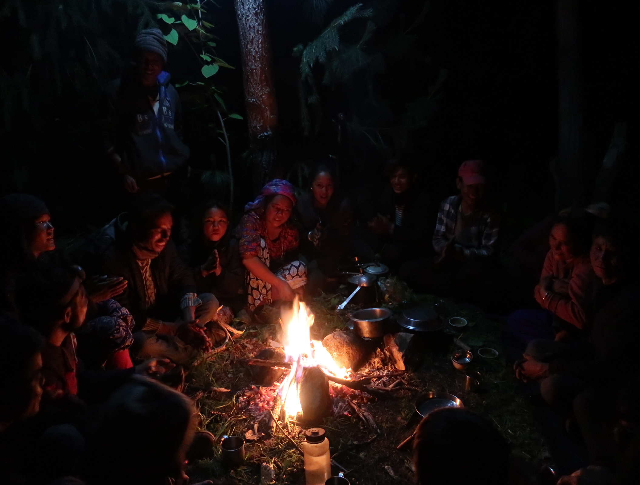
374. Ramesh and Dawa in the makeshift kitchen with the drizzle pouring down. We cooked on kerosene and Ramesh could always be relied on to produce a great dalbhat.
We found an easy campsite where the Phoksudo Khola stream entered the lake in a wide flat valley. Horses grazed the flat pastures here and horsemen galloped across the meadow on easy ground. There was a single bhatti here and we camped nearby, and beside a spring which bubbled from the ground. As we put the tent up it started to rain so we also rigged up a shelter to cook under with a tarpaulin. Ramesh was protected from the rain under it and as usual made a great dalbhat for all of us. There were streams of yarsagumba pickers heading south past the tent all late afternoon, their season over and them no doubt happy to be going back to the comfort of their village. Their yarsagumba picking month would be the same as a bunch of Europeans going on a months adventure together with lots of stories to tell when home. The rain eventually eased as it got dark and we all piled into our large tent which was our home.
June 26. Phoksumdo Khola delta to Kangla High Camp. 14km. 5.5 hours. 940m up. 70m down. It was overcast when we woke naturally in the morning. Today it was Santos’s turn to do the breakfast and as I was contemplating getting out of my sleeping bag he suddenly appeared with a mug of coffee and a plate of instant noodles spiced up with cumin seeds. We took the tent down now like a well-oiled machine and set off at 0730.
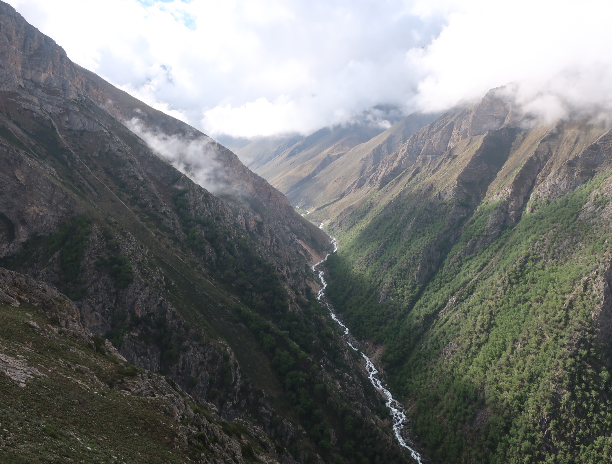
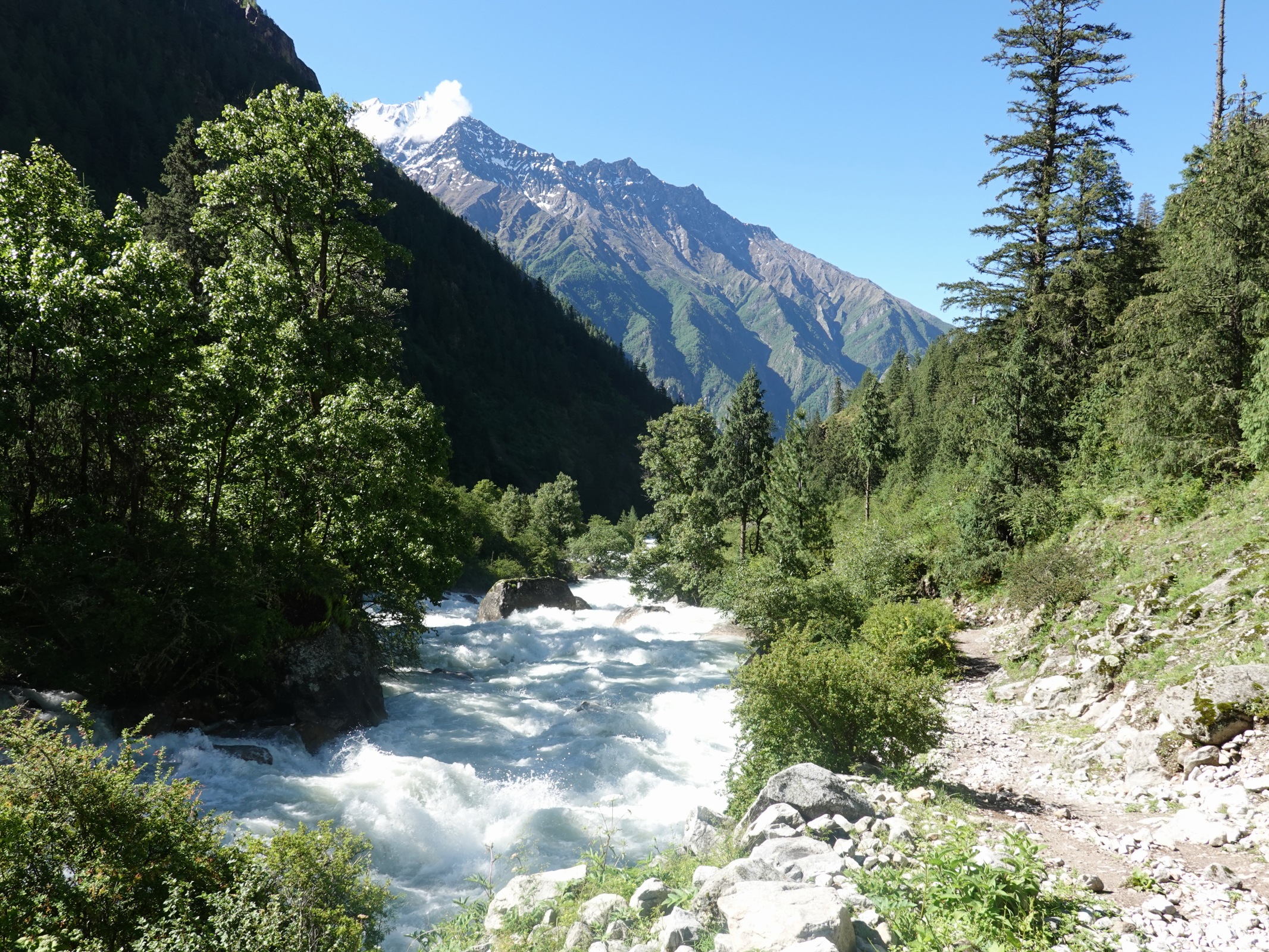
It was an easy walk up the flat meadow for a couple of km with the river flowing strongly to our east. The meadow ended in a Bhutan pine forest which stretched across the kilometre wide valley and extended all the way up to the confluence of the two main streams. It was a beautiful walk and at times I could have imagined I was in North America. The mist obscured the views especially up to Kanjiroba whose glaciated ramparts disappeared into the clouds on our west. The summit was almost three vertical kilometres above us. The path passed through many areas of avalanche debris where smashed birch and bent willows were emerging from the packed snow. There must have been a tremendous flood here sometime because the river had deposited swathes of cobbles deep into the forest. We had to cross the main river once on a log as the cantilever bridge was destroyed by this flood. It was a raging torrent and would have swept anyone away had they lost their balance. Ramesh was very wary of water and was full on concentration when he crossed. On the east side the pines continued but it was really the realm of the birch. Some 7-8 kilometres from camp the valley narrowed and the flat open floodplain vanished as we entered a gorge. At the south end of this gorge was the confluence of the two streams and we left the larger north fork and headed up the east fork.

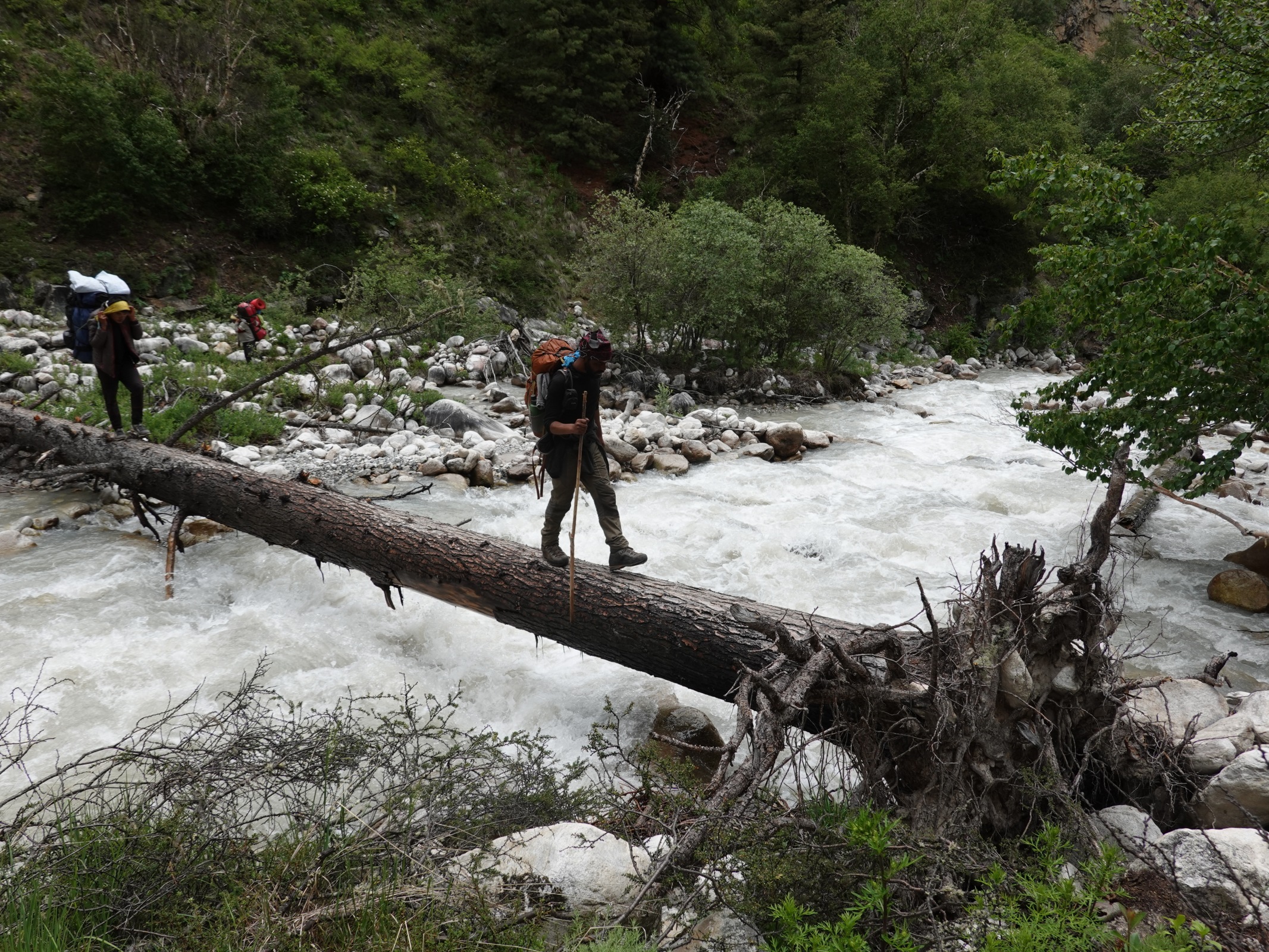
375. At the end of Phoksumdo Khola stream we had to follow a gorge with a stream for three hours. The stream had to be crossed frequently. Here is the athletic Santos leaping across with a good 30 kg on his head.

376. Looking back down the lower reaches of the gorge where a few other people can just be seen coming up and negotiating a crossing
The east fork tumbled down from high above in a deep rocky gorge whose bottom was clogged with cobbles, stones and the occasional boulder creating a 20 meter wide floor with the white frothing stream weaving a route through them. The very rough path went up the stones but frequently the torrent went right up to the gorge walls forcing one to cross it. Where it was braided it was just possible to hop across boulders but where it was a single torrent one had to wade it. There were a few makeshift bridges out of fallen birch trees and slippery logs and Ishunned these as I was already wet, and waded the torrent. A slip from a log would have meant a complete soaking rather than a wash from the knees down. We had to cross the stream about 10 times in all. As we climbed there were a lot of snow bridges where avalanches had crashed down in the spring and these bridges were still thick and strong.
There were a few horses coming down and one just behind me and the snow bridges were thick enough for them also. I chatted with the one who caught me up. The horseman was called OnJok and he was from Bhijer. He was a wild looking Tibetan who was a strong as his horse. He was leading his horse up the slope as it was laden with the baggage of a policeman who was going to Bhijer to take up a 6 or 12 month post. The young policeman spoke to me a few times but I found him obnoxious so let them get ahead. After a good hour, perhaps nearer 90 minutes the gorge finally opened out into a high stony valley.

377. Gonjok and his horse crossing a snow bridge in the gorge while carrying a policeman’s belongings to Biher. I was later to contact Gonjok in Biher and he helped us.
This U shaped valley was full of wild flowers and alpines. Many varieties of Saxifrage grew amongst the stones. Unfortunately it was misty and drizzling, so the steep mountains on each side were largely obscured, only revealing themselves momentarily when the mist weakened for a minute. There was a small cave beside the path and I waited in its mouth to avoid the drizzle while the others appeared. By now Onjok and the policeman were well ahead. When the others arrived they dumped their loads, put a cobble on a large boulder 30 metres away and we then all stood in the mount of the cave hurling stones at the cobble. The Nepalis were remarkable shots and Santos would make a great cricketer with powerful and accurate throws. It was inevitably his rock which dislodged the cobble after 15 minutes of hurling. By the time we were finished the rain was off and we were all in high spirits. From here it was just another 15 minutes up the shallow u shaped valley to the high camp.
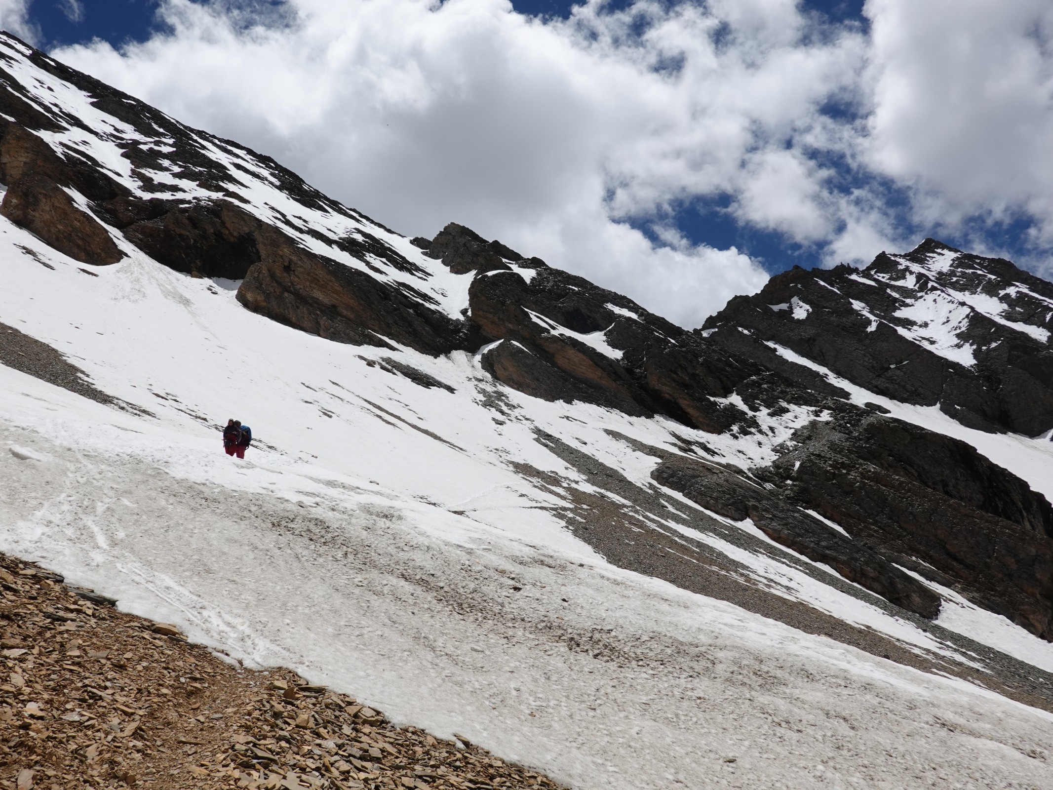
It was a poor campsite but going on ran the risk of not having one at all. There was one space where the tent would fit and it was stony but softened with years of mule dung which had broken down into a peaty mix. With the rain returning we quickly put the tent up beside a stone shelter which had collapsed due to this springs snowfall on its once flat roof. With the tent up we made Ramesh a kitchen area using the remaining wall of the stone shelter and a tarpaulin, and in return he made us a kettle of tea. Once in the tent it was dry and cosy and the others soon followed suit for a relaxing afternoon of playing games while I wrote. Occasionally they would break into song with Dawa and Santos leading the folk songs. Despite the rain morale was high. There was just a glimpse or two of the pass we had to go over tomorrow which was about 800m above us at 5560m.

378. Approaching the top of the Kangla pass 5350m, between Phoksumdo and Shey Gompa. Here is the view SW to Kangiroba Himal, (the mountain not the range)
27 June. Kangla High Camp to Shey Gomba. 16km. 4.5 hours. 760m up. 1050m down. When I woke at 0300 the weather was disappointing as the mist had failed to clear overnight. However when Santos sprung up at 0530 it had cleared and there were even rumours of blue skies. When I got up at 0600 with the others there were indeed clear blue skies and down the valley we slogged up yesterday rose the magnificent Kangiroba Himal. It was just one peak around 6600m and rather confusingly the Kangiroba Himal range was some 20 km to the NW and slightly higher. As we had breakfast though some high cloud formed on the surrounding peaks and a bit of mist condensed in the valleys. My heart sank; here we go again I thought.
It was a short 15 minute hike up the valley to the start of a 200m climb. The spots I thought might be good for camping were hopeless and we were right to camp where we did. The 200m climb took us up to a new U shaped flat bottomed valley and it looked like the pass was straight ahead. However the map, Bharat and Santos pointed up a steep scree covered hillside which looked much more arduous. Santos and myself took the long way where the path made a gentle long zig-zag while the others took the short cut up the steep hillside. A good hour later Santos and myself reached the top first and had better views as the cloud was retreating and the mist vanished. There was a magnificent view at the top down the valley we were going to descend by. I could not see Shey Gompa but the adjacent Crystal Mountain was obvious.

379. Looking E from the top of the Kangla Pass to the Dansilla Lek range. Beyond these mountains is the Tarap valley from a week ago.

380. Looking back up to the Kangla pass from the north side, before starting the pastoral descent to Shey Gompa.
The descent was initially steep but then we traversed across easy small broken scree to drop down towards a large pasture. There were many wildflowers among the stones and they were getting nourished by small trickles from the melting snowfields. We passed a small azure silt laden lake beneath some magnificent geological folds before entering the pasture. I was on my own now as the others stopped for a break and I suddenly found myself amongst enormous yak, which must have all been male. They looked at me and then slowly shuffled out of the way to my relief. At the end of the long pasture the path followed a stony flat valley for a few km. A group of about 15 horsemen came towards me and were very warm in their greetings. It seems that Namaste had now been replaced with the Tibetan Tashi Dalek. The horsemen almost looked like they were on an official outing but they were all of Tibetan origin and were returning to Dunai, the district capital.

381. Grazing yak in the valley between the Kangla Pass and Shey Gompa. The pass itself is out of the picture to the left.
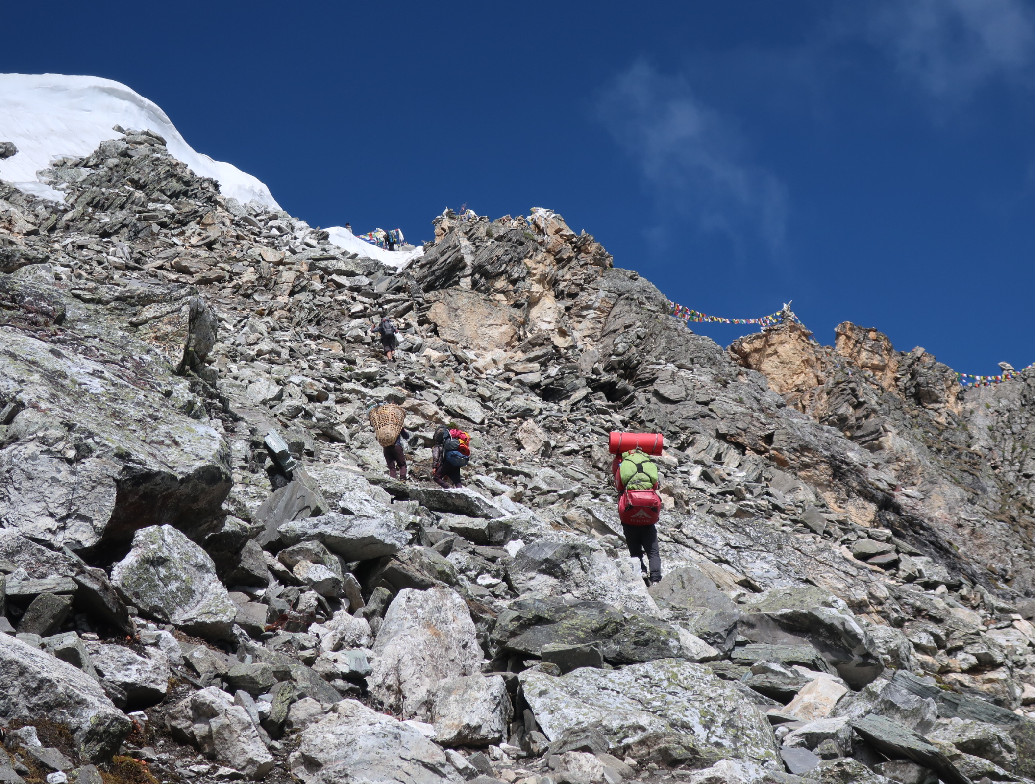
As I neared the area where I thought the monastery was mani walls became more prolific. Then I heard a tapping sound to see someone beside the river inscribing a rock with a hammer. The script he was inscribing on the boulders was in Tibetan and it looked like “Om Mani Padme”. I passed a line of clear springs bubbling up through the rock and then flowing across the path into the clear river. I stopped to drink at one spring and it was cold and refreshing. The weather was just getting better all the time; it was now still and calm, the sun was hot and the skies almost completely a deep blue velvet.
I reached another long mani wall, rounded a spur and there just a couple of kilometres away on a shelf above the river was the treasured Shey Gompa, the spiritual heart of Dolpo, which was a 1000 year old monastery. It was quite small and there looked like there was no monks’ accommodation, just the Lamas and the caretakers. Around it were a few small houses which looked like they belonged to ordinary herding families. Shey Gompa has long had a fascination with westerners who regard it as a mystical place. Beside it is the large mountain of Crystal Mountain, and some devotees take a day to circumnavigate the mountain, clockwise off course as it is a Nyingma monastery and not a Bonpo one. I was enthralled to be arriving at Shey Gompa after all these years of reading and hearing about it. It probably owes its importance also due to its location on the side of the side on a green grassy slope at the confluence of two streams, but more significantly it is central in Upper Dolpo and easily accessible from Bijar and Saldang and marginally accessible from Dho Tarap and Phoksumdo.

382. Shey Gompa from the river in from of it. To the left is the caretakers rooms and some storage rooms. To the right are some of the few houses in Shey Gompa.
I went down to the bridge over the river where there were a cluster of prayer wheels driven by water chutes and waited for Santos who was just behind me. He led me up the slope to the grassy field to the west of the monastery where there was an official campsite. It was a lovely place and the monastery and few adjoining houses were our neighbours. Down in valley just below on the other side of the bridge and water driven prayer wheels was a large flat area, which would once have been great pasture but now was a collection of tents, comprising the yarsagumba pickers who had not thrown in the towel yet, a few bhattis, and a few herders. I hope they do not despoil the area with glass as they often do, for this is a special place.

383. Shey Gompa. Perhaps the spiritual heart of Dolpo and certainly one of the best known monasteries in the area.

384. The large imposing chorten at Shey Gompa with the all seeing eyes. It was the first structure when one came up from the river.
We put the tent up near the room which was designated as a kitchen. Ramesh approved of it and he soon had it laid out as he wanted and started cooking us a dalbhat. After the meal I went over to look at the monastery. The Lama was away but there was a delightful old couple, he was a bit of a mischievous monk and she was kindly, who were the caretakers and they showed me round. It was not as impressive as I expected and it was essentially just one room with an altar, drums, an special chair for the Lama, many good condition paintings on the walls depicting Buddhist lore, a large collection of statues and a large collection of old holy scripts in their pigeon holes. However there was nowhere for more than three or four monks to sit and it seemed the monastery was almost dormant. Bharat explained that there is a huge fair here every August on the flat land across the bridge and I should imagine the place become very lively then. After the visit I went into the caretakers’ quarters where I had tea with the couple who Bharat later told me had lost two children in the last two years due to avalanches on the paths.

385. The caretaker at Shey Gompa. He looked after the place with his wife. They had just lost two children in different avalanches in the last years

386. Inside Shey Gompa with the unbound books, paintings and drums used during pujas. The lady is the caretakers’ wife and would walk round the whole compound many times a day.

387. The old unbound books used during the prayers. These are probably photocopies with the originals being too fragile and valuable to use.
I returned to the camp to discover the black hose providing a trickle of water flowed down the bare hillside for a while and it was warm when it left the hose. I stripped down to my shorts and had a makeshift hot shower at 4350 metres which was almost pleasant. I dried quickly in the hot sun under the still blue skies and then went down to the flat area across the bridge to take some photos of the monastery. The others also had a shower and then then all had a well-deserved snooze on the grass with the sun making them lethargic. They did all go and visit the monastery and the caretaker couple later. It was the type of afternoon we all dream of really; the simple pleasure of a warm water hose, soporific sun, a special Shangri-La type place and a 1000 year old monastery.
28 June. Shey Gomba to Biher. 27 km. 8 hours. 1320m up. 1820m down. Santos, who slept in the kitchen brought us all a cup of tea at 0500 and we drunk the first cup in our sleeping bags and the second cup milling around the green pasture where the tent was. It was overcast and the nice weather of yesterday seemed to be on the retreat. However when we set of at 0630 and headed straight up the hill more and more blue sky started to appear, and it seemed this charge of monsoon rain did not have the momentum to make it over all the Himalayas to the south and petered out around Phoksumdo.
The path did not follow the map but went straight up the hill above the monastery and then veered north for a km before heading east into a high valley where there was a summer pasture. It comprised of a large single storey stone shelter and four or five tents. There were sheep and goats just leaving the safety of their night compound to go a graze the hillsides while the chauri were wandering about being milked or waiting to be milked by the woman of the herding family. Across the main valley were many other pastures and I could just make out the cluster of tents in the pastures and the dark brown circles of the goat compounds which were bare earth and manure. From this kharka the path continued to climb up the spur on the north side of the side valley for another half hour or so until it reached an unmarked pass at around 4850m.
The weather was now great and I could look across the main valley to Crystal Mountain on the other side with its geological folds and small snowfields. The next stage of our day’s journey was laid out before us to the north and east. The path dropped down into side valley of the Den Khola curved around the bowl where there was a confluence of rivulets and then climbed up the spur on the north side to a distant saddle. The whole crossing of the Den Khola took about two hours and was made all the more interesting by two clusters of stone shelters in kharkas. I made a small detour into the heart of one of them just to see what was going on and ask some banal question to which I already knew the answer just to strike up some simple conservation like a mutual “where are you from; where are you going” type of thing. I was well ahead of the others and it empowered me a little that I could have a simple conservation in Nepali now, albeit at the level of a three year old.
I stopped at the bottom of the climb up the north spur of Den Khola side valley and the others caught up and we lazed in the morning sun on a path of grass. Large yak grazed nearby but they seemed wary of us and kept their distance. The climb up was a slog for a good hour but the plants, especially the alpines which were all in flower kept my interest. In the main valley the river, called the Tarting Khola was deep in an impenetrable canyon, perhaps a 600-800 metres deep and this is why the path had to follow the hillsides and side valleys far above it. As I made my way to the saddle I came across a group of Bijer horseman having a picnic. They were on their way to Dunai, the District headquarters of Dolpo. They offered me a tea and invited me to sit with them. Their English was great due to the French sponsored school in Bijer. We chatted for 20 minutes on the grass until the others arrived and the four horsemen packed to continue their journey.
At the saddle another side valley unfolded in front of us. It was steep and quite short but there was an excellent path which almost contoured perfectly round the loose small scree to the next spur. It only took half an hour to reach the prayer flags on the far side. En route there were some quite exposed sections but the horses had managed so I should also. From this spur the fourth and final side valley of the day lay before me and it looked easy and pleasant.

388. En route to Bhijer I came across the Lama of Shyamling Gompa, a Bonpo monastery off on a detour to the west of the path.
There was a small drop down to a large pastoral bowl. On my way down I passed near two men picking something. I assumed yarsagumba. They summoned me over and I was surprised to see he was a lama. He was picking the small yellow rhododendron flowers which he would use as incense in the monastery. He was the lama of the Shyamling Gompa near the village of Tata. It was a Bonpo Gompa as opposed to a Nyingma Buddhist Gompa. The Lama and his assistant, a young 15 year old had ridden up here on their horses. Both were enthusiastic talkers and both had good English. We chatted for a good 15 minutes and I found the Lama very warm hearted. His gomba was not on my route which was a shame as it must have had an excellent view over the Tarting Khola canyon. Just quarter of an hour later I met another horseman at a stream. He was tightening the saddle for the climb. He happened to be the Lama of Shey Gompa returning from a meeting in Bijer. Again I chatted with him for 10 minutes, and found him to be kindly also but his English was as bad as my Nepali.
In the middle of this pastoral bowl was a very well organized Kharka called Taro. It had about eight almost identical single store stone shelters in the middle of the main pasture. They were all empty bar one which had a very wild unkempt shepherd who refused a photo. He had about 200 goats and sheep on pasture. After a very brief chat with him I climbed to the top of the last spur and then began the long descent to Bijer which revealed itself quite soon down in the bottom of yet another side valley. The descent was not that steep but the vegetation was sparse with just thorny scrub and many types of alpines.

389. The green corn and barley fields of Bhijer in the sun. Bhijer was like an oasis in the dry scrub covered brown hills. It was green because of the irrigation.

390. Looking down on Bhijer from the ridge to the north of it while en route to Pho. The ridge opposite was the one we came over yesterday.
Arriving in Bijer was exciting. I could see it was a beautiful ancient village dating back hundreds if not thousands of years. It had a collection of perhaps 75 old stone houses. The top floors were open sided rooms used for storage and in front of them the flat roofs were good for drying crops and then processing them. The middle floor was living quarters and the ground floor was storage and perhaps some animals. All the floors were connected by simple loft ladders. There was not the same attention to store wood on the parapets as there was say in Chharka Bhot, but the houses looked just as imposing. There were some huge chortens at the top and bottom of the village and a Bonpo Gompa at the top end and a Nyingma Buddhst Gompa at the lower end.
I crossed the bridge, found Onjok’s house, which was locked, and then wondered up the village path where I saw a group of people. One was Onjok’s cousin and he confirmed the house and said the local shop was just up the path. He was a teacher at the French school and his English was great. I must say I have found the people of Dolpo, the Dolpapa, extremely helpful and friendly as a group. The local shop had most of the items we needed, rice, kerosene, noodles, powdered milk etc for the next seven days until Mugugoan. As we milled around the shop Onjok walked by, returning from the fields. I was pleased to see him as I had been hatching a plan. The next two days were very long and the porters with their large loads topped up by the local shop would probably not manage. So I wanted to hire Onjok and his horse for these two days to carry 50kg. Thereafter the three porters would manage. Onjok agreed and a price of 4500 rupees a day for him and horse was established. When I told Ramesh, Santos and Dawa they were surprised and delighted.
After this I went for a walk in the village which took nearly two hours. It was fascinating and perhaps even exceeded Ringmo as my favourite Dolpo village, or indeed village on this whole journey. The solid castille like houses were surrounded by bright green well irrigated fields of young corn and buckwheat. The irrigation looked very well organized and turned the whole village into an oasis in an otherwise parched arid landscape. As I wandered through the alleys and passages between houses people greeted me with enthusiasm. The Nyingma Monastery was quite large with monks’ quarters for perhaps 20 monks. The actual monastery looked very old and I guess it was over 500 years while the Bonpo one looked perhaps just 100 or so. I returned to the campsite full of awe and joy that such places still exist in today’s world. Bijer really was a Shangri-La and I was very much looking forward to travelling with Onjok for the next few days as he seemed one of the village’s respected elders.
29 June. Biher to Pho. 19 km. 7 hours. 1670m up. 1470m down. Konjok arrived at 0600 just to what was happening. Despite getting up at 0430 we were still packing and sorting out the gear to get 50 kg for the horse. Eventually we were packed and the horse was loaded just before 0700 and we set off as the sun warming the village and turning the wheat fields a bright green. We wove through the houses and then started a steep climb up the ridge on the north of the village. Unfortunately even at this early hour we were getting hit by the sun and everyone was down to one layer after a couple of hundred metres. I walked ahead of Gonjok and his horse who was slowly gaining on me. The others were already trailing despite their 15 kg loads. The path was of an even relentless gradient but it was well made and the gradient was just right to gain height without getting exhausted. It climbed for about 600-700m up the ridge with the view of Bijer getting ever more impressive. It was a lovely village here tucked away in a remote and arid corner of Dolpo, well off any trekking route or trading corridor.
From the top of the ridge I could see the path to the high point of the day, the Yumbar La pass, about 4800. The route to it was reasonably easy and I again walked with Gonjok and his horse as we contoured round the bowl of the Yumbar Khola. The bowl descended into a gorge then plunged down to the main valley where the Tarting Khola flowed in a deep canyon. Konjok pointed out a Gompa to me. I could barely see it at first as its ochre walls camouflaged it in the yellow and sienna rocks of the gorge. It was perched on a large shelf and was very remote. Gonjok said it was very old, perhaps 2800 years. This surprised me as that was some 300 years before Buddha, but perhaps there was a building here long before him and it was used for religious purposes, but the valley looked totally unsuitable for farming. At the end of the bowl we climbed steeply for half an hour up to the pass. Just before it we saw a herd of 50 blue sheep and Gonjok said there was snow leopard in the area.
391. Looking north from the Yambur La Pass, 4813m, between Bhijer to Pho to the Palchung Hamga Himal. The pointed mountain to the right is Damphesail, 6100, on the Tibet border.
I expected a view at the pass but the one which burst on me in the final steps was breathtaking. To the north were the Kanti and Palchung Humga Himals. They were not that high at around 6000m, but they were covered in glaciers and steep ridges of fluted snow. Below them were barren, parched mountain sides of a dull yellow and above them was the clear velvet blue sky. These mountains formed the border with Tibet, and the flat Tibetan plateau was on the other side. To the south where were had been was range after range. Unfortunately the highest of the all, the Kanjirobi Himal with its near 7000m peaks were partly obscured by cloud. Konjok was keen to descend to a meadow on the north side of the pass just five minutes away so we went down there and unloaded the horse so he could rest and graze.

392. Looking NW from the Yambur La Pass to the village of Pho. There is a deep canyon with the Dolpo Karnali in it between us and the village though. Tomorrows pass, the Nyingma Gyanzen La, 5563m, is actually one of the highest mountains on the right.
The others caught us up in the meadow and we all snacked and then snoozed for 15-20 minutes. We could see the path descend into a very deep valley before climbing up an arid bare rocky slope to the green oasis of Pho whose houses sat on the barren hillside above the striking green terraces fields. Gonjok started to get ready first and we loaded the horse and set off down the slope past the not very pastoral Pho Kharka and on down into the deep gorge. It was carved by the river which drained the north of Dolpo and it was locally called the Dolpo Karnali. It eventually joined the Mugu and then Humla Karnali to form a huge river. The descent was relentless and try as I might I could not keep up with Gonjok and his horse. They were 10% faster than me and I also stopped to take photos, which widened the gap. The others were far behind. We plunged down some 1400m from the pass with the landscape getting drier and drier. We passed more blue sheep but I could not see what they ate except the thorn bushes.

393. The deep canyon which contains the Dolpo Karnali. It was spanned by a single old rickety stone and log cantilever bridge which Gonjok remembers from hs childhood.
Gonjok stopped at the first and only small trickle we came to so the horse could drink and graze a bit and he could get a stick from one of the willow trees which formed a strip down the rivulet. He was 53 and his knee was sore. He told me his horse was 30, which surprised me. I caught him up here and we walked together for the rest of the descent to the Dolpo Karnali. It was a very deep gorge and the path was quite convoluted. At one corner the whole gorge suddenly opened up and I could see the infamous wobbly stone and log cantilever bridge over the dark deep river. It was perhaps the largest of these bridges I had seen and it was old. It was a remarkable construction and it kept the hamlet of Pho in contact with Bijer and then the rest of the world. I went first across the bridge so I could get some photos of Gonjok leading his horse across.

394. Gonjok leading his horse across the bridge over the Dolpo Karnali.
The bottom of the gorge was about 3400 metres and we now had a 650 metre climb up the west side of the gorge to Pho. It was a long hot dry climb and I regretted not drinking from the rivulet half an hour before the bridge. I put myself into low gear and just did the climb in one go with Gonjok and his very tired horse following. He said he liked the slow steady speed so I was not pressured into letting him past. The others were far behind and we were well up the west side of the gorge and onto the barren hillside, with just a few willow trees where some underground spring trickled under the boulders, when they reached the bridge. It took well over an hour to finally reach the top of the steep, hot, dry and uninteresting climb and arrive at the lowest of the green fields in the oasis of Pho. The fields were quite extensive and were planted with young potatoes and wheat. In the middle of the fields was an old gomba which while in good repair looked like it was no longer used. We circled the north side of the fields slowly climbing towards the cluster of houses and chotens. At the lowest chorten Gonjok signalled that we should leave the path and head off to a terrace where there was the official campsite. Beside the campsite was a spring gushing out of the ground and down a chute. It was beautiful, sweet cold water and I drunk two litres. The spring was also the source of the oasis like green fields as it was sufficient to irrigate them all. There was a lush small meadow under the spring with 20 cm high grass and wild flowers. Once we unloaded the horse he made a beeline for it and starting gorging himself. Gonjok and I snoozed on the horse blankets waiting for the others to arrive an hour later. They were not too tired but were thirsty. Ramesh unpacked his basket into the three sided stone shelter which was the kitchen and made us tea and me noodles while we put the tent up on the flat terrace. The horse was still gorging himself without let up.

395. The green fields of Pho with the old monastery in the midst of them. The village of 10 or so houses lies at the top of the fields and above the beautiful spring, which allows the village to exist.
I went to explore the village before the sun went down. There were perhaps 10 houses in use and 10 in bad repair. Of the 10 in use nearly all were at some lake looking for yarsagumba and there were just two older ladies and some young children here. It was so far away from any beaten track even one old lady would have been enough to look after and guard the village. It perhaps ranks equal with Thudam as the most remote place on out walk so far. I should imagine in 20-30 years everyone here will have either immigrated to Bijer or died and the village will be abandoned. What happens in the rest of the world makes no difference here, not even a nuclear war. What matters here is what occurs in this small oasis, the bridge over the Karnali connecting Pho with the Bijer and the price of yarsagumba this year. It is a shame this village will be abandoned as it has probably been inhabited for many centuries and this heritage will go to waste. In the evening the two ladies visited and we bought potatoes and tsampa from them as the chura we bought in Bijer was riddled with weevils and mouse droppings and has to be thrown.
As night fell it became windstill and calm. The blue sky became colourless and then darkened as the stars got brighter. It was an incredibly peaceful place where each day is much the same as the next but with different subsistence chores in the fields. The simplicity of life here has long vanished from most other people’s lives.
30 June. Pho to Pung Charka. 24 km 8.5 hours. 1850m up. 1220m down. The alarm went at 0430 again. Gonjok was up like a shot to check on his horse. I got Santos up who was sleeping in the kitchen and he got started on the teas. By the time we were ready to go it was 0630. We wandered up through the village and one of the older ladies came out and gave Gonjok a thermos of Tibetan tea with some salt and butter in it and also a thick greenish roti bread made out of buckwheat flour. I had assumed now we were so far north in the Himalayas the weather would be similar to Tibet, but another monsoon rain was trying to get past the ranges to the south and the day at Pho was overcast with mist higher up.
We headed up the path behind the village at the start of 1500m climb. Gonjok insisted I go in front of him and the horse as my slow steady pace suited them. However I knew that team was slightly faster. The others were trailing up at their own speed probably quite relieved they had there minimum loads of 15-20kg with the horse taking 15kg each from them. I wanted to do the whole climb in one go, probably taking four hours, and this suited Gonjok, who was a strong man. We climbed up together for a good two hours to reach the top of a ridge at about 5000m, already an ascent of 900m. However the top of it was all in the mist and I knew I was missing some great views. At the top of this ridge we turned north and followed the ridge as it gently climbed up the crest for another hour. Again the mist obscured any view but occasionally it cleared for a few hundred metres and it could see the crest ahead. Gonjok and the horse now went ahead and there were some very atmospheric views of this hardy Dolpopa leading his horse along the crest of a 5000m plus ridge with snow fields each side in the mist. Eventually we got to a top and I thought that was it but no there was another. It deflated me and I felt sapped and was now struggling to keep up. I hoped Bharat and the others had taken the right route in the mist as they were perhaps half an hour behind.

396. Gonjok leading his horse along the ridge, well above 5000m, towards the Nyingma Gyanzen La Pass further up the ridge. He was very good to his horse.
We descended from the false top and Gonjok stopped for a rare pause. I caught up and then took it as a cue to pause for lunch as it was approaching 1000 and my tank was empty. Gonjok gave me some buckwheat bread to have with the potato curry Ramesh had made. The bread tasted like the houses smelt, smoky and a bit musty, but it was certainly filling. As we ate the mist cleared a bit and I could see the climb up to the final top. It looked quite steep and there was the odd snowfield. On starting up though the path was not as bad as it looked and the snowfields were soft and the horse skirted round the edge of them. At last after nearly four hours we reached the top with its modest collection of prayer flags. I don’t think many people come this way. It was not a pass as such but a mountain top and as path went over it, as the only alternative, it was called a pass; the Nyingma Gyanzen La, 5563m.
Just beyond the top was a deeper snowdrift across the path and Gonjok was worried about the horse but he just made it up. However not far beyond was a huge steep snowfield at about 35 degrees and 200-300 metres high and 100 metres wide with a steep exit on the far side. Gonjok said it was not possible for the horse to cross it and in the likely event of it slipping it would either die or have to be put down. He had had the horse for decades and it was part of his family and I could see he cared for it. There was no way round the snowfield so it seemed he would leave the bags here and turn back. Our conversation was a bit muted so we waited for the others to arrive. Dawa was first and as an experience mountaineer he went to have a look at the snowfield. He returned to say that even for the humans it was dangerous and a slip would result in crashing into stones at some speed far below. We found an alternative route along the sharp crest of the airy exposed ridge but there was no way a horse could manage that. The 50 kg of luggage the horse carried were distributed between Ramesh, Santos and Dawa. I felt their loads and they were huge, perhaps 35 kg, yet none complained. I paid Gonjok for the full three days which were agreed, two days carrying and a day to return even though he could not complete the two days load carrying. It was not his fault but I did wonder if he knew the route would be impossible for his horse before we started. He would return to Pho tonight and Bijer tomorrow. We all agreed he had no intention to cheat us and was in fact an honourable man. The losers were the three porters who would have to carry a huge load at the end of a long day. We all shook hands with Gonjok and wished him well for his return and then watched him lead his horse into the mist and back to Pho where the horse would enjoy the lush pasture again.
We continued north along the knife edge ridge for 200 metres. The rock was exceedingly sharp and a slip here would result in bad cuts. Santos, full of bravado as always, headed off first and lead the way. At the end of the ridge there was a route down a bouldery slope of the sharp stones until it met the path as it emerged from the snowfield. We followed the path down on the west side of the ridge for 15 minutes until we got to a saddle. Here there was a deep notch in the ridge, called Ridge Pass, and we slipped through it to the east side.
Initially on the east side the descent was very steep and Dawa said the horse would have had great difficulty here on the gravel covered rock. After 100m of descent an easier path formed and this led down to an open bowl where the side valley which came up from below fanned out into a crescent of snowfields leading up to a crescent of jagged ridges, with the notch in the middle. We had a second lunch here. It was a 1000m descent from the notch down the side valley into a deep canyon far below. We had just done 200m of this before our break so had another 800 to go. It was a knee jerker as the path was mostly composed of sharper stones loosely packed together in a shallow trench. It wove down between boulder fields and small crags and occasionally zig-zagged. It was certainly a seldom used path and at times difficult to see its course. A few hundred metres before the end it plunged more steeply into the gorge of the Swaksa Khola river. As I started down the final plunge I flushed a herd of some 50 blue sheep. They initially ran up the slope and then the lead male with huge horns lead the herd up some very steep crags. They bounded up from shelf to shelf nimbly and with such ease you felt a snow leopard would be hard pushed to follow them in this terrain.

397. On the descent from the Nyingma Gyanzen La Pass I flushed a herd of blue sheep who scampered off across the craggy buttress with ease.

398. After the decent from the Nyingma Gyanzen La Pass we reached the canyon of the Swaska Khola Valley which we had to follow for two hours up to the pastures of Pung Kharka.
At last I arrived at the Swaska Khola whose crystal clear waters flowed from the Tibet border. I waited for the others before we began our final push of the long day. It was basically a long gentle 4 km climb up the west side of the stream. The others were surprising fast with their loads as they followed the stony path. It took a good hour and a half to haul ourselves up. Far ahead I could see yak wandering about Pung Charka, unfortunately they looked tiny and I hoped they were goats, but they were yak. Slowly the valley opened out as we gently climbed up it. At the last bit there was a slog up a sandy embankment which the river had eroded to reach the large pastures. They were cut by a stream coming down from a side valley and all the yak were on the other side. I decided to camp on the south side of this stream away from the yak as some of them might bother us or as has happened before to me in Dolpo, chew on some of the guy ropes. The pasture was lumpy but we found a less lumpy sheltered bit and collapsed around it. The others soon recovered and we put the tent up while Ramesh made a kitchen in the late afternoon sun. The weather was certainly improving and I hope it is clear for our 21st 5000m pass tomorrow the Yala la.

399. The pastures of Pung Kharka and the kharka above were full of grazing yak who had been brought up here to graze on the rich summer grasses watered by glacial streams and the monsoon.
Pung Charka to Kaitpuchonam Khola. 18km. 8 hours. 910m up. 1520 m down. Despite the free rein regarding the alarm clock Santos was woken just after 0500 and hoped up to make the teas for the rest of us, which we had in bed as it was overcast and threatened to drizzle, as it had done in the night. We were away by 0700 and headed up across Pung Charka. It was a beautiful undulating pasture but the tufts of grass here were large and made camping difficult. We spotted a couple of sites on the north side of the side stream. It was a long pasture perhaps as much as 3 km and offered some great grazing for the yaks. The weather started to improve almost immediately and by the time we reached the end of the pasture in the U-shaped valley there were many blue patches of sky.
We now walked along beneath some impressive craggy mountains beside the lazy stream which was so clear. Along the bottom of the craggy mountain were vast slopes of scree and at the bottom of them were the valley floor started was a line of bubbling springs. Some were large enough we could not hop over and had to detour up the scree a bit to get round them. We then turned a corner and arrived at another charka with a large tent in the middle of the meadow. All the yaks I had seen yesterday were now gathered here with perhaps 100 grazing. There were also a few yarsagumba tents and there was a large group which seemed to be leaving with their rucksacks loaded high. The charka was quite idyllic with the stream meandering across the pastures and the yak either grazing or sitting on the grass in the sun chewing there cud. Many were huge with large ferocious horns curved back at the sharp tips. It seemed to be fashionable here to weave a segment of a prayer flag into the long hair on the yaks shoulders. We left this idyllic scene in this far flung corner of Dolpo and started up the steep slope to the Yala La pass. We pretty quickly caught up with the large group of yarsagumba hunters who were searching as we climbed. They found quite a few between them and I could see them occasionally digging with their narrow mattocks. I chatted with a few on the ascent and found out they were from near Jumla, one of my favourite places in Nepal.
We chatted as we climbed and they searched. All of a sudden I was beckoned over by two men who found one and asked me to photograph the harvest. It was almost invisible to me but to the trained eye the fungus protruding from the earth must be obvious. It was dug up and then proudly displayed. They reckoned this one would be about US$ 10, a day’s wages in Jumla, and I think he would get about 10 a day. They had been picking for about 30 days, with five days travel in addition at each end, and it represented a significant proportion of the years income for most families, even in this poor year where there were very little and the permit was about US$300. It was a steep climb for about 400m. At a small stream I passed by a very large blue sheep which must have died in an avalanche this winter.

400. At the end of his finger is the fungal stalk of the infected caterpillar which is now dead. It is this tiny sign which all yarsagumba collectors want to see for beneath lies about US$10.

401. The yarsagumba collector and his recently dug up bounty. This fat one is worth about US$13. It now needs to be cleaned with a toothbrush and dried, before being sold to a buyer who visit the collecting grounds frequently
At the top of the climb I could look down onto the meadow and see the yak slowly lumbering about in the sun as the stream meandered in its stone bed. At the north end of the meadow was a huge wall of snow and ice which was part of the Palchung Hamga Himal with its 6000m peaks. It formed the border with Tibet. Looking west from the steep climb I could now see the pass up a headwall beyond a great bowl of scree. The others were ahead and stopped by boulders near the small stream which drained the bowl. A few of the yarsagumba hunters were also gathering there and when I arrived there were about 20 people. We all left in groups to climb up the scree to the headwall. I chatted to a few but when I spoke to the younger women they just giggled. I felt tired after the last three longer days and was the last of our group up to the pass as I found the headwall taxing, even though the pass was just 5400m.

402. En route up to the Yala La Pass and just where the yarsagumba was found. Below is the kharka above Pung Kharka.

403. The steep descent to the west of the Yala La Pass, 5414. The yarsagumba collectors descended with ease in the crocs while we were much more cautious in our boots.
The descent was much more difficult than I had anticipated with large steep snowfields on the west side. They were about 35 degrees but as they were south facing they were generally soft. However where rocks protruded they were icy. I was thankful for the yarsagumba hunters who had come this way a month ago when it was all snow. They bounded across the slopes with great confidence and even the giggling girls caught me up and overtook me. Beneath the snowfields were slabs, covered in wet gravel and between the snowfields were slabs covered in dry gravel which had been levelled by 1000s of feet into a loose path, which I don’t think even an unladen horse would have managed. Santos took an unusual route and got into a bit of difficulty on the icy interface between slab and snowfield and even Dawa was very unhappy at a couple of sections as both had shoes with virtually no tread. I moved very gingerly until I was off the steep sections and onto a large shallower snowfield when I overtook the giggling girls.
404. At the bottom of the snowfields after Yala la Pass. The steeper snowfields cannot really be seen. The pass is centre right.
The path now had two more sections of steeper descents on zig-zags covered in dry gravel. Where this sat on bare rock everyone had to be quite cautious until at last we spilled out onto the valley floor. The yarsagumba hunters from Jumla now fanned out and dropped to their hand and knees and a few had a lot of luck and found a couple in half an hour. I left them and followed the path down the crest of a small moraine ridge for a good couple of km. The sun came and went and lit the grassy valley up when the occasional clouds did not obscure it. I noticed there were people on their knees everywhere in the valley, I spied perhaps 100 of them. After the moraine ridge ended the valley opened out even more into a huge grassy shelf between the high craggy mountains on each side and the burgeoning stream. After the Chyandi Khola entered the valley from the north where it rose at the bottom of a glacier beneath a large mountain covered in icefalls, the stream swelled and was now a raging torrent. There were some nice camp spots here, and I waited for the others at one and slumbered in the sun. The yarsagumba hunters all streamed passed and after half an hour Bharat and Co arrived. He wanted to forego these campspots in favour of the large cave down valley which the yarsagumba hunters were staying at and said had good campsites. I was sceptical and warned all that if the cave was unsuitable we would not stay but would push on. It was a gamble and a few were hesitant about continuing.

405. Yarsagumba collectors’ tents high up the Chayandi Khola valley at about 4800 metres. About 6-8 people will spend a month in these tents looking for yarsagumba all day, before packing up and returning to their villages hopefully with a few hundred pieces each.
The grassy shelf in the valley narrowed and started to slope a bit when we reached a large yarsagumba camp with about 30 conical tents. A few tents had already gone leaving a circle of yellow grass where the storm flaps covered the grass and an inner circle bare earth and detritus of plastic wrappers and bottles, some glass, where the inhabitants had stayed. When I saw this I was worried about the cave below where we were heading. As the valley narrowed more a gorge started to form and the path was forced down to the tumbling torrent. It followed a difficult line at the bottom of the eroded embankments for a good hour. At one stage it climbed over a very slippery steep buttress and I after watching the others struggle thought it was easier to wade the torrent to avoid it. I was lucky as there was a birch log bridge to recross 100m lower down. As I finished shuffling over the bridge, shorts dripping wet, I found myself at the cave camp.

406. Santos descending a tricky bit in the lower part of the Chyandi Khola before it got too difficult to follow and a buttress force us up and over a high spur.
It was much worse than I feared. The cave was barely an overhang and it was full of old fire paces many of which the Jumla yarsagumba hunters were now using, there was no room for us under the overhang which would not have kept us dry in a rain shower if there was any southerly wind anyway. Beyond the overhang was a flatter area but about 15 tents had recently vacated the area and it was covered in rubbish and broken glass and what was natural was dense clumps of thorn bushes. I told Bharat the tent was not getting unpacked in this area. The three porters also thought it was grim. I used Bharat to quiz the friendliest of the Jumla hunters and he said there was another spot at the confluence of the 2 rivers half an hour downstream. I guessed the half an hour would be an hour but there was no option as I was not staying here.
We had a quick meal of noodles and I set of while the others packed. There was no bridge across the raging torrent below here so we had to stay on the north side of it, as crossing it now was dangerous. However the path was virtually non-existent or I lost it. I followed the torrent down beneath crumbling eroded banks, usually very steep. After half an hour when I was once forced into knee deep water but a buttress I arrived at an impasse. A buttress rose from the raging waters and it was impossible to climb round or wade round. The others arrived after 10 minutes and we had a conference. In the meantime Ramesh had a hunch the path was higher and went off to explore while Dawa, our climbing expert, had a go at the buttress. Dawa said it was too difficult with loads but Ramesh returned to say he found the path and it lead, very, very steeply over a spur.
The climb up to the path, which was barely visible, and then up the spur was indeed steep. I could hardly get traction on the sandy soil and the others were slipping under their loads. After 100 metres or so of this struggle up through the scrub and thorn bushes we crested the spur. The descent was just as steep but it was down through Himalayan Birch, with the woodland floor covered in blue geraniums. After slithering down the earth slope we arrived at the much smaller Kaitpuchonam Khola which looked wadeable. The spur we just climbed over was the spur between the two torrents, each in its own canyon.
We all waded the Kaitpuchonam Khola and to its west bank and there under some large birch trees was a lovely camping spot which we could just squeeze the large tent into. Everyone was delighted, especially the porters who had been carrying their very heavy, but diminishing daily, loads for well over eight hours. Ramesh set about making a kitchen, while Bharat and Dawa collected firewood to dry the shoes and socks. It was a nice peaceful end to another long day, with just the roar of the torrents audible. We were supposed to stop three hours upstream in the meadows but I am glad we have got the difficult section down the north side of the Chyandi Khola out of the way as it mean we can go for the high camp of the next 5000 metre pass tomorrow, which will make its crossing much easier.
June 02. Kaitpuchonam Khola to Chyargo La High Camp east. 12 km. 5 hours. 1130m up. 840m down. After a nice night tucked away between the large birches beside the roaring river we woke to a foggy damp morning. As usual Santos was up first to make the team tea. We then got up, breakfasted, packed up and were off by 0700. The path had to climb some 450 metres over a spur between the Chyandi and the Takya Khola streams, both of them in gorges. Our first task was to climb west out of the gorge we camped in.
Dawa led the way up a steep and muddy path in the mist. There was very little to see except the scrubby bushes which were wet with dew and soaked our legs and feet. After 200 metres the others paused to rest but with my lighter load I wanted to carry on to the top. I climbed perhaps another 100 metres and seemed to break through the mist getting the occasional view down the Chyandi khola valley. I could see it remained in a gorge with steep sides and these were often covered in birch or a conifer, Bhutan pine I think. As I climbed further the gradient eased and the views improved with frequent sunny intervals. I could see all the way up the Chyandi Khola behind me to where the cave camp was, then the silvery ribbon of the torrent led up to the flatter grassy areas where the yarsagumba camp was and in the far distance I could see the pass we came over yesterday. Ahead the small faint path curved round the bowl as it slowly climbed up to the crest of the spur.
407. Looking east back up the Chyandi Khola from the spur between it and the Takla Khola. This descent down the north (left) side of the stream gave us problems yesterday.

408. Looking west from the spur between the Chanandi and Takla Khola streams up the Chhimaru Khola stream valley to our next campsite at the last green. The pass goes up left of the camp and small pointed peak.
It was a lovely traverse up, full of flowers and small shrubby bushes in bloom. However many were thorny and overhung the path and my bare legs were scratched. After nearly two hours I finally scrambled up the last band of rock to reach the three small chortens which marked the crest of the ridge. It was sunny and most of the mist had cleared but some lingered on distant ridges and gave the landscape a mysterious atmosphere. To the west the spur dropped away to Takya Khola deep in the valley some 700 metres below. It seemed remarkably close and I could easily make out individual trees on the valley floor. The Takya Khola stream seemed massive though and there was no way we could wade it so I prayed for a bridge. Beyond it was the gently sloping Chhimimau Khola valley which looked green and verdant with many copses of birch trees. Near the top of this valley was a meadow just at the foot of the Chyargo La Pass. It was here we intended to camp.
I could not see the others so I had my snack and was just about to snooze in the sun when they appeared at the top of the side ridge. We relaxed for 15 minutes before setting off. On the descent we passed through a vast patch of white flowers, which had geranium type leaves but were not geraniums. It was a spectacular and soothing sight. The path traversed down the hillside to a side spur and then crossed it to arrive at the top of a steep gully full of old venerable birch. The path now plummeted down through this verdant wood zig-zagging wildly. Occasionally I dislodged a stone and it just rolled down through the grass and geranium undergrowth so steep was the descent.
It took us down to the valley floor where the stream roared. On the other side at the confluence of two streams was a flatter area covered in large Bhutan pines and birch. One of the pines had been undercut by the torrent and had collapsed across the stream spanning it creating a natural bridge. I was ahead so crossed and then took up a viewing seat amongst the pines waiting to photo the others crossing. They all crossed with aplomb and confidence. There were some nice campsites here but it was just 1100. Instead we decided to have a full blown meal which took 40 minutes to cook and another 40 to eat and digest. It was a rare moment to relax in the middle of the day. While Ramesh cooked we tidied up the campsites and burnt some of the discarded plastic and clothing, left by hundreds of yarsagumba hunting groups. It was a lovely setting and I could easily have been in the Sierra Nevada mountains of California such was the temperature, the mix of trees and the roar of the streams.
409. Bharat crossing the Takya Khola on a fortuitous log which saved us wading the powerful and cold torrent.
After lunch we headed up the Chhimimau Khola side valley towards the 22nd 5000m pass, the Chyargo La, 5150m. This valley was a paradise. Huge Himalayan birches, many specimen trees, grew in copses of diminishing size as we ascended. Between the copses were masses of rose bushes all in flower, with either white or pink flowers. There were also some meadows where umbellifers thrived, especially Angelica and what looked like wild rhubarb. There were mauve geraniums everywhere especially under the birches and when we ascended more there were pink ones. The ferocious frothing tumbled down boulders and it was still frequently spanned by snow bridges of avalanche debris, now dirty as the embedded grit and stone was coming to the surface. It was so green and verdant I could easily have imagined I was in the mountains of west Norway.

410. The view up to the Charygo La Pass, 5150m, from near our campsite. The last section was quite steep.
411. The last section of climbing to reach the top of the Charygo La Pass. The top of the pass was covered in chortens and prayer flags.
As we ascended though the sun became more hesitant to show itself and the lush birch woods and verdant undergrowth vanished and the berberis, dwarf juniper and tussock grass took over. By the time we reached the green plateau I had seen a few hours ago rain threatened and the meadow surface was actually scrubby and lumpy. In addition there was a cold wind. However we found an exposed breezy site for the tent and had it up just as the rain arrived. We could not fashion a kitchen for Ramesh and he had to endure an hour and a half of miserable weather while he cooked the evening meal for us. He was wrapped up well but had water dripping off the end of his nose and fingers the whole time. He brought all the pots into the tent to serve up to the rest of us who were sheltering in the warmth. Now we have left Dolpo and the protective ranges to the south of it I think we can expect wetter weather for the next fortnight.

412. The view east from the top of the Charygo La Pass. At the bottom is our campsite and in the distance the mountains around Yala La Pass from a couple of days ago.
3 July. Chyargo La High Camp east to Shilenchaura Charka. 22km. 8.5 hours. 810m up. 2240m down. The weather had completely changed by the morning and it had all the promise of a glorious day. Santos as usual made us all tea at 0530 and we were off by 0700. As we prepared to go a large team of some 30 yarsagumba collectors from Jumla went past. They were all of the Lama caste and were friendly and chatty. We walked past the enormous spring, crossed the tiny stream about the spring and started up the slope to the Chyargo La pass. It was a straight 700m climb up a mix of grassy sections and less frequent boulder sections. The Lama group were going the same way and we often walked together. With the sun out it became warm very quickly. Towards the top of the climb some great views opened up but cloud patches obscured some of the peaks. The Kanti Himal range to the north looked very impressive.

413. Looking north from the top of the Charygo La Pass to one of the mountains in the Kanti Himal on the Tibet border some 8 km away.

414. Looking west from the Chargyo La Pass down the Chham Khola valley where we are about to descend to Thajuchaur meadow and on to Shilenchaura Kharka to camp.

415. A group of yarsagumba collectors heading home to Jumla after a month in the mountains. This group were all lamas, an ethnic group in Nepal of Bhuddist folk you live in the higher hill regions.
Towards the top was a section where stones embedded in the snowfields above broke free and rolled down the slope. It happened about three times. There were shouts from the Lamas to warn everyone each time one came down. I passed the alley where the stones rolled down and then heard shouts. I looked up to see a stone rolling down to Ramesh and co who had stopped in the alley. I shouted “dunga” but I think they were already aware of it. It missed Dawa by about five metres. There were a few small snowfields to cross before the pass which was surprisingly steep for the last 20 or so metres. The pass itself was covered in stone chortens. There were about 30 of them, and all were connected by prayer flags. It was a very colourful pass. Half the lamas were here having a picnic. The views here were great and I took many photos. To the west lay the rest of the day which involved a long 2200m descent all the way down the valley to the Mugu Karnali. The mountains each side of this valley, The Chamm Khola, were relatively modest at under 6000m, but held a surprising amount of snow and ice and were very imposing.

416. The Lamas all heading down the west side of the Charygo La pass. They were heading home to Jumla some 3-4 days hard walking away.
The descent was down boulders, the remnants of snowfields, and the steep grass for about 500 metres. The Lama group just behind were singing and whooping as they slid down the snowfields on their bums. There was a festive mood with them now they were returning to their village after a month in a tent, grafting all day on their hands and knees. Some had collected as many as 700 yarsagumba which they would sell for about US$7 each.
After this steeper, taxing section the valley became a gentle grassy slope for the next hour all the way to the huge meadow of Thajuchaur. It was easy walking, the flowers were stunning, the scenery was breathtaking, and the weather was great. It is rare one gets such a gentle stroll in Nepal but this was certainly one. The white geranium type flower was everywhere and the whole meadow was covered in it. There were also copses of birch and amongst them were small tents of yarsagumba collectors. It seemed through there was an exodus from the hunting grounds back to the villages. At the end of Thajuchaur were a couple of seasonal tent bhattis selling provisions at inflated prices to the collectors and then the Babar Khola stream, which I could just cross by hopping across stones.

417. Approaching the large lush meadow at Thajuchaur. The meadow had some yarsagumba collectors’ camps, but no herders were based here.
After this the valley changed drastically as it became heavily wooded with birch and it also narrowed into a V shape with an ever increasing roaring torrent to the south of the path. Often the birch woods were a joy to walk through as it was cool, verdant and lush. The path crossed the torrent to the south side over a log bridge, then back to the north across a vast snow bridge, then back to the south side again over another snowbridge of avalanche debris and finally to the north side again over a log bridge, all in the space of 2 km. If the snow bridges were not there I am not sure where the path would go as each side had buttresses which the crossings avoided. The vegetation was lush and it smelt of full summer with the umbellifers pungent as they dominated where the trees were absent.

418. Some of the very fertile vegetation just below Thajuchaur meadow. The valley was warm, humid and everything was bursting into summer foliage.
About half way down on the south side was a vast bowl which rose up nearly 3 km to glaciated ramparts of a cirque of peaks. Huge avalanches must crash down this bowl each winter as the bottom of the bowl was bare, all vegetation devastated annually. On the north side of the torrent only willows and short lived plants could survive, at one stage there was a field of umbellifers nearly my height.
After this bowl the path entered fir forests, they were the western form of the Himalayan Silver Fir I think, although they were no bigger than the normal variety. They still had the same resinous smell. The firs and birch grew together in a delightful forest with sparse undergrowth except in the glades where lush, verdant plants erupted. The path in some of these areas was also a delight as it was easy underfoot and near level due to the topography of the valley. However it was not to last.

419. As the path descended to Shilenchaur Kharka and the great Mugu Karnali river more and more conifers appeared and the path was a delight until the valley sides closed in and a gorge formed.

420. The gorge just before meeting the Mugu Karnali river was deep and the path steep. The sides of the gorge were lined with conifers were the rock allowed.
Soon the torrent started a ferocious descent towards the Mugu Karnali gorge a kilometre down over 3 kilometres distance. The path stayed on the north side dropping steeply but occasionally it had to climb over spurs, some with frightening exposed drops into the gorge. The trees now became very mixed with Bhutan Pine and West Himalayan Spruce and all manner of deciduous trees including poplars. All the conifers were heavy with cones forming, purple erect ones for the firs and drooping green ones for the pines and spruce. All the time the roar of the torrent, which was just short of a waterfall, was everywhere reverberating off the walls of the gorge. It took a good two hours from the bowl and four from Thajachaur meadow to descend roughly down to the level of the Mugu Karnali. Here the path could not really follow the north bank any more due to the bouldery terrain so it crossed over the Chhar Khola, which was now just a rushing torrent rather than a shade short of a waterfall, on a solid log bridge. The path on the south side undulated through the exclusively spruce forest now, with some huge trees, for a km until it came to a tent bhatti. There was another good bridge over to the north side and a flat sandy area at the bottom of the spur between the Chhar Khola and the Mugu Karnali. There was a sheltered area in the mixed woods here which was ideal for camping. I went on a bit to look at the bridge over the Mugu Karnali but could see there were a lot of bhattis on the other side and did not want to enter into that kind of commercial life just yet so retreated back to the clearing to camp. The others arrived after a few minutes.
We had set up the camp when suddenly the 30 or so Lamas arrived. They had five large conical tents and cut down five small trees as a centre pole. They then lit five fires. I was worried sparks might land on our tent but they kept the fires small. After nightfall the others went over to one of the tents where there was some singing and joined in. The women of that group were very melodic and kept a good harmony. I imagine that Santos and Dawa, both good singers, quickly found their voice.
421. The returning group of Lamas who were going to Jumla camped beside us. There were about 30 of them in all and they were delighted to be going home. They sang songs round their camp fire for a few hours and Bharat, Ramesh,Santos and Dawa joined them.
4 July. Shilenchaura Charka to Mugugoan. 9 km. 3.5 hours. 590m up. 150m down. There was a thunderstorm as it was getting light and the rain poured down on the tent. Santos did not spring up at 0530 but had to be encouraged at 0600 just as the rain was easing. The group of lamas in their five tents were already well on the way to dismantling their camp and setting off. We eventually set off around 0730. It was wet underfoot and all the branches we had to push through were dripping wet. I walked with four Jumla ladies who were returning from the yarsagumba and they showed me where the bridge was. It was a good km upstream from where we camped. En route up to it we walked beside the Mugu Karnali on the bank with branches dripping on us and slippery boulders underfoot.
I had expected the Mugu Karnali to be big, but it was huge and certainly in spate. This winter and spring’s heavy snowfall was leading to an increased melt and the water level was lapping at the trees and shrubs along the bank. The river itself was very powerful and very fast. I reckoned it was moving at over 15kmph, about as fast as I could run. It would have swept the biggest horse away and even an elephant would have to be extremely selective where it crossed. Me and the four Jumla ladies cross on a log bridge. Usually I was blasé about the log bridges but on this one I was very cautious as one slip into the river would be my last slip. On the other side the Jumla ladies lined up for a photo.

422. Crossing the Mugu Karnali on a log and stone cantilever bridge. One slip here on the wet logs and it was all over. These ladies crossing were also yarsagumba collectors on the way home.

423. The four ladies crossing the Mugu Karnali Bridge and now on their way home with their yarsagumba to sell. They were also going to Jumla.
On the map there was a road from here to Mugugoan, and indeed on to a 5000m pass on the Tibet border. However there was no road at all to Mugugaon, it was just a mule track with occasional rocky parts or stream crossings. You might be able to take a scrambler motorbike along most of it but that was all. Walking was easy and pleasant though as the gradient was shallow. I walked up the west bank now and was soon into spruce and pine forest. Poplars were also common, their leaves fluttering even though there was no wind. All the time the roar of the river was ever present and almost oppressive. Where the path was very close there was a spray in the air which occasionally formed small rainbows. Behind me the skies were clear now and I could see the snowy ridges of the mountains we walked beneath yesterday.
After two hours there was an old long bridge across the river where a gargantuan boulder overhung the track. It lead to a path on the other side which went up to Ura Gompa sited on a spruce clad spur on the other side. I could see the glistening stupas and the prayer flags fluttering. I did not visit as I had been before. A little after was a new suspension bridge to yet another monastery which looked new. The tall conifers now petered out and the small junipers took over the hillsides. Beneath they was a blaze of flowers especially the iris type plant and white geranium type flowers. I photographed many of them. Ahead I could see the river continue to rise up to a lip. I knew that beyond the lip was a beautiful meadow where the river was much lazier and braided. It was beside this meadow that the village of Mugugoan sat.
424. Looking down the torrent of the Mugu Karnali as it crashed down the valley towards our previous campsite at Shilenchaur Kharka. About six rivers this size join to form the Karnali, a major tributary of the Ganges.

425. The Mugu Karnali as it leaves the flat valley where Mugugaon village is. For the next 10 km the valley above Mugugaon is a pastoral Shangri-La.
At the lip I passed a variety of chortens and kami gates to enter the meadow. The village had a lot more tin roofs and had added many more buildings since I was last here. I crossed the small bridge over the slower deeper river as it meandered across the meadow and entered the village. Many of the older rickety stone buildings which seemed to have unique stick and mud walls seemed to have collapsed or fallen down. And newer stone built one with tin roofs built in their place. I met someone who had a tent bhatti and he said his uncle had a nice homestay. It was in one of the newer buildings. His English was remarkably good. There was a great kitchen Ramesh could use and the four lads could comfortably sleep in it while I had a musty room beneath them with lots of wooden chest sealed with mud so mice could not get to the grains stored inside. It had a balcony with a great view over the meadow and he river, which formed a flat island. On the island was a statue of Buddha emerging from a lotus flower. I showed our host pictures from our last visit and they included the families’ prayer room of the homestay we used. It was the same family. They had knocked the previous house down and built this one on the same plot. The previous host was now in the monastery and his son had taken over.

426. One of the rickety houses in Mugugaon with its log ladders to go from one floor to the next. Since I was last here about half of these older houses had been pulled, or fallen, down. There were replaced with stone houses with tin roofs.
The village had a couple of provision suppliers, a small hydro plant, the monastery and a large presence of police due to its proximity with Tibet and the trading route over the nearby pass. The police were also here to monitor the yarsagumba collectors who might number a few thousand in the valleys around here. The only issue was there was no kerosene. We had three litres to get us from here to Simikot, about seven days away which was not nearly enough, but much of it was below the treeline so we could use wood. The host said he could also organize a horse for us to take us over the Takya Lek pass, about 5020m, about one and a half days march north of here. It is not a trekking pass at all but one which must be used by yarsagumba collectors and one which I went over 11 years ago when last here.
This resupply point at Mugu seemed the best place to end Section 12. Upper Dolpo, even though we left Dolpo three days ago at Yala La pass. Lower and Upper Dolpo, from Kagbeni to Mugugaon, had been the most fascinating sections so far and also one of the most challenging. The passes had not been that hard but there were eight of them over 5000 metres. I had expected a more rolling landscape but instead there were high mountains and massifs riven by huge impassable canyons and gorges. What added to the enjoyment of trekking through Dolpo was the culture, from the medieval villages like Chharka Bhot, Dho Tarap, Ringmo and Bijer to the mysterious gompas like Phoksumdo and Shey and the eclectic Buddhism they practiced. The people of Dolpo were also genuinely friendly and like no others in Nepal, except for Limi Valley. The people here are essentially Tibetan and by quirk of geography and politics remain part of the original Tibetan culture now being erased in Tibet by China. It has been my equal favourite section so far, along with the high passes between Makalu and Everest. The Next one, Section 13. Mugu to Humla, is well off the beaten path and off piste.
Section 12. Upper Dolpo. 10 Days. 170 km. 62 hours. 10580m up. 11010m down.