Raja Ampat Paddle

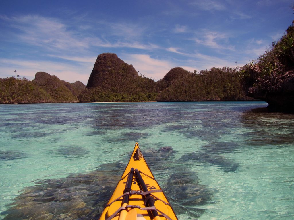
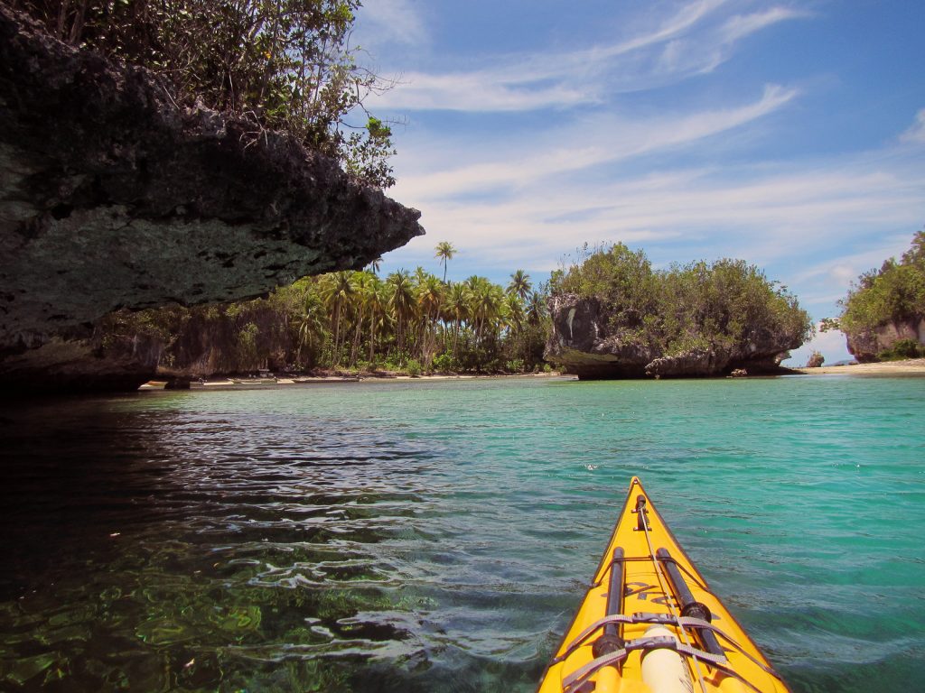
Raja Ampat Kayak. Day 01. 10 Feb 2016. Seporkreng to Feey yef. 20 km. 5 hours. Sony and I left Mandos homestay, where the kayak rental is currently based and headed west to Seporkreng village, a typical West Papuan fishing village. Just beyond we said farewell to the Dampier Strait and headed up a channel between Waigeo Island and Gam Island, the end of which is marked by 3 forested islands. After passing through the islands and entering the large sheltered Kabui Bay, where we will spend the next 2 days.
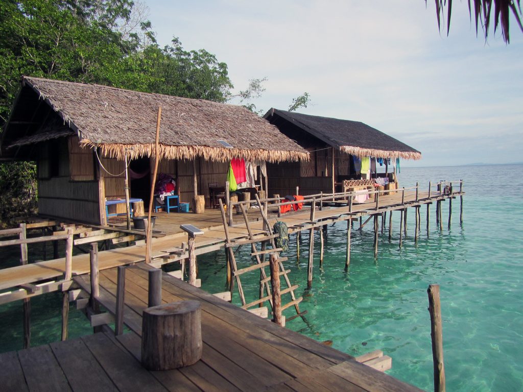
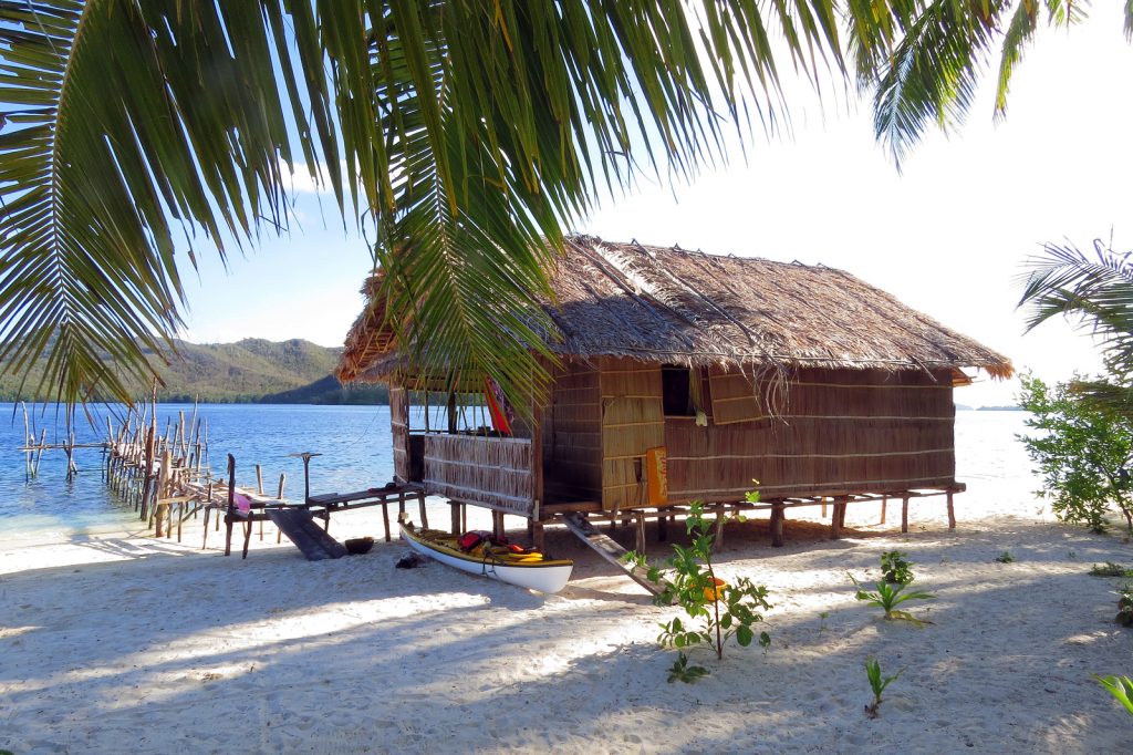
02. The small Mandos Homestay was built on stilts over the sea. There were 4 rooms and a dining area. The kayaks belonging to RARCC organization Kayak4Conservation were stored near here and I was lucky to be able to rent one
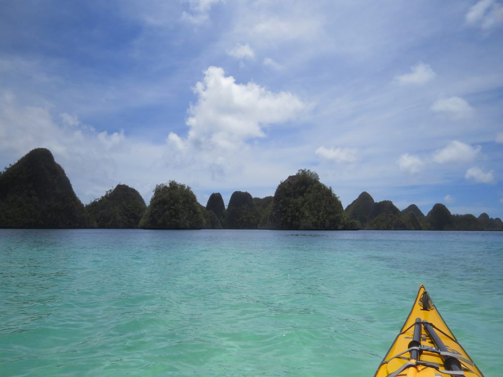
As we paddled into this forested wonderland the beaches soon made way for karst. It is only visible along the shore as everything else is covered in thick jungle with some tall trees and palms. Every bit of karst shoreline is undercut by at least one metre and occasionally 10 metres. They are impenetrable from the sea for their entire length. We paddled north up this east shore line passing occasional mangroves in clogged bays and also some alluvial plains where coconuts grow or have been cultivated. There are some sparse shacks from time to time on this stretch. We landed at one and the grove owner, a relative of Sony’s, cut down 7 coconuts. I drank the milk from three and scooped the jelly-like flesh forming in them. It was 1300 now and we were tired after the early start and many tweaking problems, so we had a 2 hour siesta under various canopies.

03. The kayak I rented was made in Raja Ampat by RARCC. It was very robust. As part of the rental package I had to take a guide who I later had to dispense with. My guide was called Sony and he wasa local from near Saporkreng village
We set off again at 1530 and continued north though the increasingly bizarre karst landscape, which was becoming more rugged with every km. Soon the coast was part of a limestone spur which descended into Kabui Bay. The remnants of the spine forming citadels in the sea like giant chessmen. It was like nothing I had seen before. Sony continued to cut under all the overhanging limestone but I was more wary of their jagged undersides despite the tiny swell. At the North West end of the bay we cut through the perforated spur and crossed the mouth of a large side bay. The NE wind whistled out of this bay ahead of a squall. We crossed to a large convoluted karst island across much of the mouth of this side bay. One reaching the island it proved to be more of the towering chessmen we just left. There were perhaps 20 of them rising from deep undercuts. We threaded through these also until we passed into the north entrance to the side bay.

05. Approaching the North East corner of Kabui Bay where there was a cluster of islands and karst towers which spanned the mouth of a side bay where the village of Waroffa (Wawiyai) lay.
Here a large village with some 50 houses and a school appeared. It was the village of Waroffa. We did not go there but headed west for half a km to more karst towers. Here between 2 shorter towers was a RARCC sponsored guest house. It was deserted when we arrived but Sony went off to tell the hosts in Waroffa while I pulled myself and kayak onto the stilt platform. The hosts arrived an hour later with a full meal and lights powered by motorbike battery. It was a simple guesthouse but perfectly suited. It was dark by the time the meal arrived.

06. The simple unstaffed guesthouse at Feey Yef where we spent the first night. The food was brought by the care taker who lived in Waroffa who cooked it there and brought it to us
Raja Ampat Kayak. Day 02. 11 Feb 2016. Feey yef to Warikaf by Passage. 22 kilometres. 4.5 hours. We left Feey yef cove and turned right (west) to go immediately into the rows of giant limestone chessmen. Those to the south are obviously smaller and more eroded than those further north against the ridges which first spawned them. After a few kilometres we reached a small and easily missed beach. At this beach there is a long log ladder which leads up past the ramparts of a karst chessman and onto the vegetation above. It is not that high but if you brave the ladder the view must be worth the 30 metre climb. We did not do the climb but instead continued to paddle west across the bay for a few kilometres along the coastline which was lined with mangroves. It was prime crocodile habitat and Sony indicated some were as big as the kayak, so we stayed half a kilometre off shore and did not linger. Sony told me Kali Raja is an ancient temple up the river here in the middle of the mangroves.

07. Heading west from Feey yef homestay across the northern shore of Karoei bay. Just after these karst towers is a river estuary covered in mangroves where there were some large crocodiles apparently
On the west side of these mangroves was another concentration of karst chessmen. There were a myriad of channels through them and some of the towers even had small tunnels. We followed these channels wary about going too far in and being trapped in a cul de sac. After a good hour with a following breeze we reached the end of this magical maze and the karst chessmen vanished leaving a stretch of open water for a good kilometre to reach a headland. After passing this forested promontory the karst chessmen reappeared as we started to head down the funnel of the V shaped entrance to the Passage. We kept to the north side and passed through some more magical passages between squat karst towers. Often the water between adjacent towers was quite shallow and where it was it was covered in coral structures and reef fish. At other times it descended into the darkness down steep plinths the karst towers sat on. After a couple of kilometres of this we crossed the narrowing neck of the funnel to the Warikaf homestay which is located on the south side near the Passage entrance.

08. Warikaf homestay was in a small bay off the main Karoei Bay. It was near a tidal stream called Passage where the water flowed in and out with the tide.
There was a local boat taking an eccentric American called, Bob Ostertag, to float snorkel down the passage on the flooding tide. On his return he said it was full on and like class 2 white water and he was out of control. I went for a more sedate snorkel round the side bay the homestead was in. That evening there was a nice meal at the homestay and I chatted with Bob and 3 Austrians I met in Mandos homestay at the start. The heat of the day was tempered by an overcast sky today, but it was the main factor for feeling tired. I slept above the water with the lapping just below the floor at one stage.

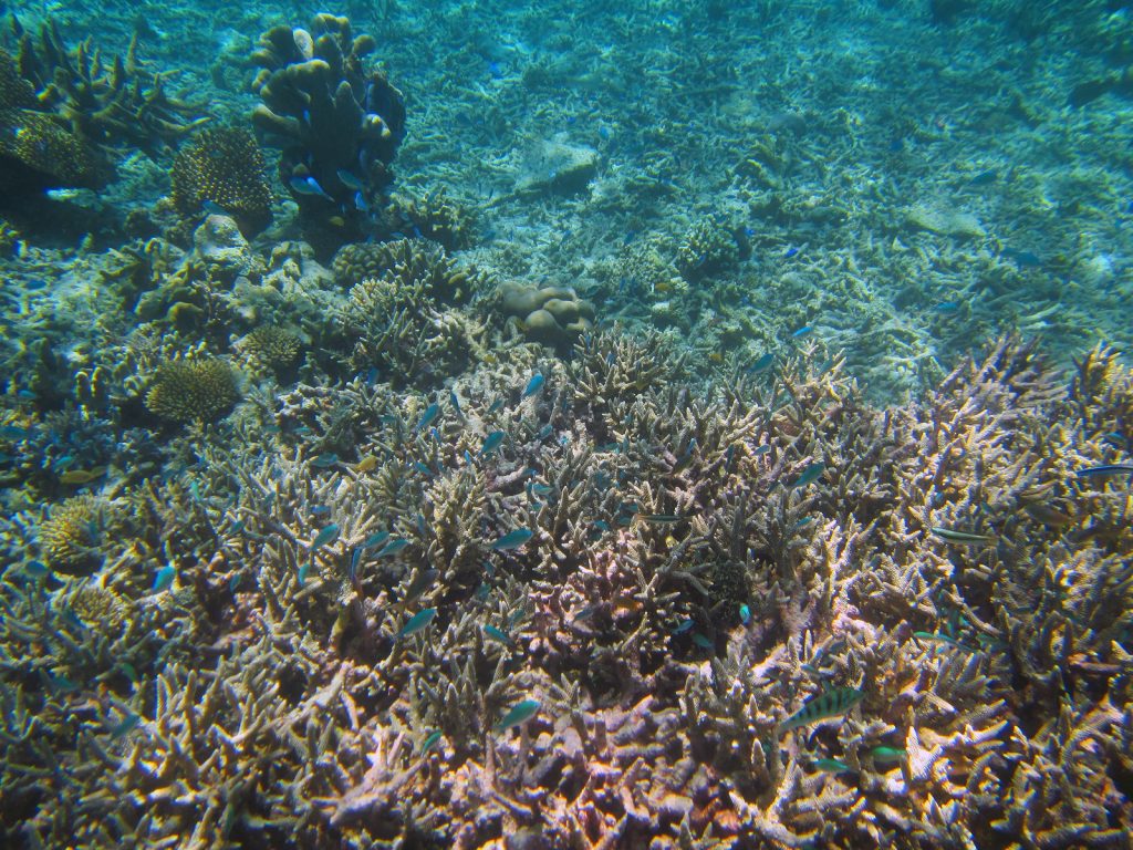
09. There were some small coral beds around Warikaf homestay some right under the houses on stilts and there was some good snorkeling around here.
Raja Ampat kayak. Day 03. 12 Feb 2016. Warikaf to Selabalam Lapo Homestay by Sarpele. 49 kilometres. 9 hours. The day started easily with an easy drift down the ebbing tide where we were carried down the 3 kilometres of the Passage and into the open sea. It was like a grade one river with a few eddies to contend with as you were swept over the corals. It would have been a marvellous drift dive at this flow. Once in the open sea we decided to go straight to a coral surrounded island where there was a homestay called Paniki. It was north of Pef and about 15 kilometres NWW of the passage outlet. There was nothing in between as we slowly closed the gap. We had to make a detour to the north of Paniki to avoid corals. The homestay was on the adjacent islet but it was deserted which was a shame as the setting was idyllic and snorkelling looked great.

10. About to head down the Passage which connects Warikaf homestay in Karoei Bay to the open sea. It was about 3 kilometres long and had a rich marine fauna.
We decided to head off to another homestay some 15 kilometres to the NWW by the village of Waisilip. There were huge coral fields to detour around en route at the midway island of Palau Gof Besar. Sony stood up in his kayak and paddled for about a kilometre to find a way through them and I was amazed at his nimbleness and skill. These corals here would have been superb to snorkel off but we pushed on. As we approached Waisilip, just to the east of two southerly peninsulas I was perturbed by the fact we did not go into the village and homestay but seemed to carry on. When I mentioned it to Sony it seemed I had inadvertently said I wanted to carry on to the next one by now and it was too late to return the 3 kilometres to Waisilip.
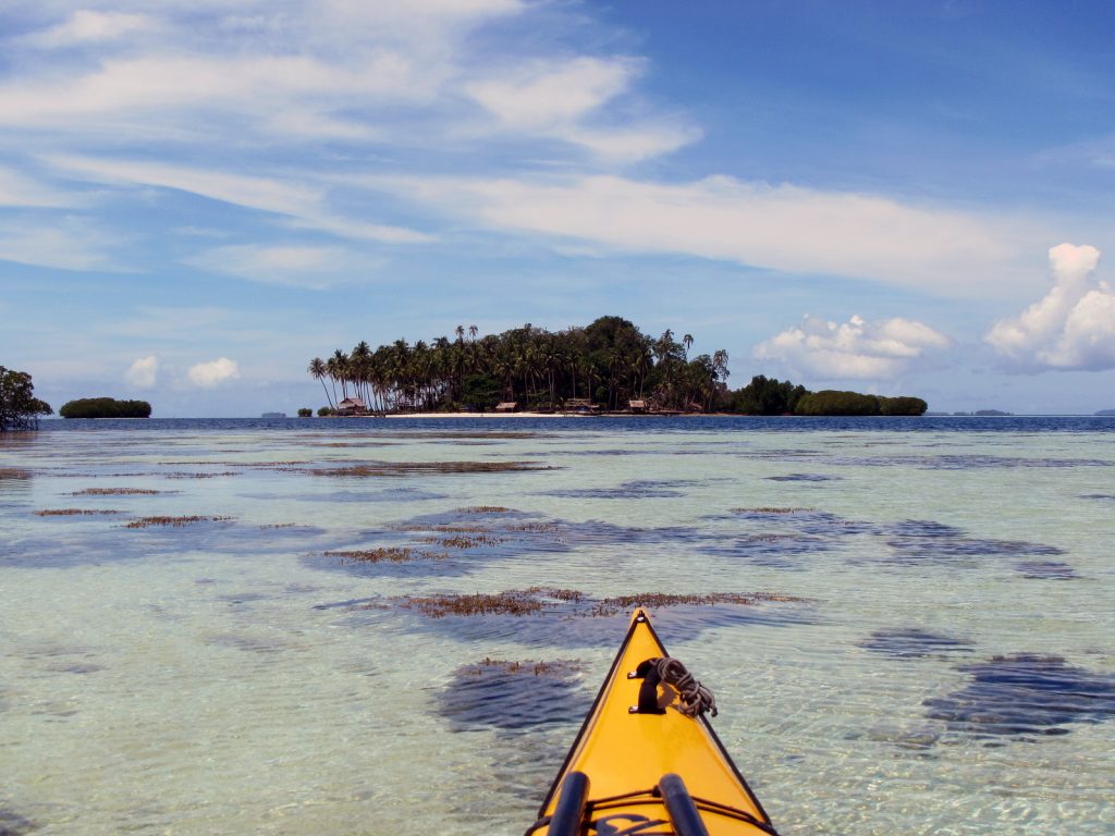
11. The small island of Paniki was a tropical paradise with a simple homestay which unfortunately was closed
I did not know where the next homestay was and Sony clammed up a bit when questioned. We rounded the twin peninsulas and then hugged the coast up a large sweeping shallow bay. It was slow progress into the headwind but slowly the rich green forest passed. Each time I thought we might reach the homestay, each time I was disappointed and it was round the next headland. After some 15 kilometres of this and with dusk approaching we pulled into a beach with a homestay but it was deserted. Sony decided we should paddle on another for another kilometre where there was another homestay called Selabalam lapo. However it too was deserted but decided to stay. Sony opened a coconut for me and I drank the juice and spooned out the flesh. Then we had one of my dehydrated meals each before crashing out. It was just shy of a 50 kilometre day. In retrospect we should have lingered at coral islands of Paniki and then headed to the homestay near Waisilip.
13. Some of the coral atolls and reefs which surrounded the east side of Pulau Gof Besar. Just beyond is the main Island of Waigeo and the unseen fishing hamlet of Waisilip
Raja Ampat kayak. Day 04. 13 Feb 2016. Selabalam lapo by Sarpele to Prajas by Salio. 18 km. 5 hours. After yesterday’s heroics we had a lazy start and we did not get going until 0900 hrs. We carried on along the south coast of this larger peninsula passing the odd homestead until after an hour we rounded the tip and reached the village of Sarpele. Here we landed as I had to buy a ticket for Wayag. It was an expensive 1 million rupiah. This seemed to be the standard boat price and a kayak paid the same as a liveaboard dive boat. I grumpily paid and wondered if Sony was on the fiddle as we could have passed by and ignored the extortionate fee. I then visited the shop for some carbonated drinks.

14. Heading west from Selabalam lapo homestay and just about to go round the end of the peninsula at the western tip of Waigeo Island to reach Sarpele village
We then set a course for the gap in the islands to the north of the Sarpele peninsula. It was a slow pull into the wind but the arrival was made exciting with a strong current flooding north through the passage to the north. Once past this junction it was a gentle cruise up 3 kilometres of calm channel with the forest covering the undercut karst. At the end of the channel we headed north up the coast to the NE tip of this island some 2 kilometres away. There was a homestay here but I did not care too much for the cigarette and beetle nut macho atmosphere. It was called Talaip and had great snorkeling options.

15. The fishing and administritive village of Sarpele where I had to buy a very expensive and unnecessary boat entry permit to visit Wajag island in a weeks time.
Sony wanted to stay but I insisted we continue to Salio so we set off heading north. We went to the west of the sandy beaches on the first island giving the corals there a wide berth and then cut across the north of it to cross the channel and enter a NW facing bay on the NW tip of Waigeo Island. Here there was a great village called Salio and across the bay on the west side was a homestay called Prajas. They were not expecting us but went on to prepare a magnificent fish grill and cool showers. I ate well and caught up with the digital duties.
Raja Ampat kayak. Day 05. 14 Feb 2016. Prajas by Salio to Prajas by Salio. 17 km. 3.5 hours. We set off in stable weather for Uranie some 25 kilometres to the north. The barometer was a constant 1010mb. We left the bay at 0830 and passed the village with some bells chiming. As we approached the headland the swell started to increase and by the time we had drawn level with the twin islets guarding the middle of the north entrance to the bay the swell was up to a good metre. We pushed on in the relative calm with just a slight wind against up. Palau Uranie looked a long way off; about 21 km to be precise. The two small islets I had identified on the map as a half way emergency stop were unsuitable. They were karst chessmen likely to be surrounded by a raging sea. We carried on with the odd whitecap appearing. Sony started to lag here and I noticed he did not have a spraydeck to hand when I asked him which alarmed me.

16. Just about to set off from the Prajas homestay to go out into the open Pacific Ocean for the 30 kilometre crossing to Uranie Island. Sony is on the left and the homestay owner in the middle
Somewhere here I saw two huge creatures in the swell with the surf lapping them. I drew closer and noticed a board back on them and a small dorsal fin. I reckoned they were a good 5m long. One slowly swam towards me with its mouth wide open. In Scotland I would have guessed a basking shark as opposed to minke whale so perhaps they were whale sharks surface feeding in the upwelling currents. Sony was still lagging so I went over to him. He did not like the current moving us out to sea where were in between Waigeo and Kave. This current was into breeze and swell direction but it was not causing anything but the smallest whitecaps. But Sony was not happy at all so I suggested going to an island on the equator off the NE tip of Kave. It is called Manamono Island. After a couple of kilometers heading towards Manamono Sony was lagging again. I returned to him to find him slumped in the cockpit complaining about a headache. The amount of super strength cigarettes and beetlenut he had been consuming I thought this likely. It seemed there was no option but to return to Prajas by Salio. I was frustrated.

17. Heading out into the Pacific Ocean from Salio en route to Uranie Island some 25 kilometres to the north. Sony was a good paddler in the sheltered waters but the exposure and swell unnervered him and we had to return to Salio where I had to get rid of him.
All is all Sony had been nothing but a nuisance. If he had been free he would not have been worth it. On the way in I decided, and I think he had already decided, it best he returned to Seporkreng. There was a good flow south of the islets guarding the bay. I paddled across the bay to reach the homestay with Sony a good 10 min behind me. I tried to phone Tertius at Kayak4 Conservation who rented me the kayak and provided me with Sony. There was no answer so I had a long rest while I worked out what to do next. Sony was back with his chums smoking and chewing beetlenut in no time. He was worse than useless and I did not want to pay for him at the homestay. Eventually Tertius phoned and spoke to Sony, me and the homestay owner. I would just pay for myself and Sony would leave on his own tomorrow while I could carry on unburdened. The rest of the afternoon was spent getting all the stuff I needed from Sony’s kayak and finding out where the water on Kave Island was, which I would need in a week.
Raja Ampat kayak. Day 06. 14 Feb 2016 Prajas by Salio to Palau Uranie West Bay. 36 km. 10 hours. I set off from Prajas at 0830 on an overcast day. I was glad to be rid of Sony as I paddled out to the citadels marking the north end of the bay. There was a current ebbing north here between them and the swell which was getting through had some confused whitecaps. As I was on my own I decided not to head straight across but to head NW for 10km to the islet on the east of Kave. There were apparently some dangerous overfalls in the flood between it and Kave Island. From this islet I would then head north to the island Sony called Manamono, which was right on the equator to the NE of Kave. If needed, I could land and camp here, or push on to Palau Uranie if I felt up for it.
The swell was the same as yesterday outside the islands with perhaps the odd one at 2m but the crests were a good 10 seconds apart. It took a while to close on the island with the dangerous overfalls and I felt little benefit of the ebbing tide. An occasional force 3 squall would come through but otherwise the weather was benign. After 2 hours I had made the vicinity of this island but could see no sign of the 2 metre standing waves which occurred on the flood tide. It was still an ebb tide I think. I turned now to Manamono, dark and jagged in the overcast sky. The journey here took longer than I thought and perhaps the flood was against me now. Certainly the was a force 3 breeze dead against me coming from the N. Slowly I pulled level with it doing just a average of 3.5 kmph. As I neared I decided to go for Palau Uranie and passed some 3 km to the east of Manamono.

18. Crossing the equator some 3 kilometres to the west of the small island Sony called Manomono. This island was just off the NE corner of the large Kave Island
Soon there was some excitement as I looked to my GPS which was telling me I was approaching the equator. When the time came it went from S to N readings. I stopped to take a photo and was shocked how quickly I drifted south again. Indeed I was now only doing 2 kmph north. The flood tide must have kicked it and I was in the middle of it. The next 4 hours were a bloodsome slog north where I only did some 10 km. The tide and the force 3 wind conspired against me. I contemplated returning to Manamono but had put too much effort in by now and the day was still young and I felt strong. Very slowly Palau Uranie got closer but I could not make our individual trees. It was a 4 hour fight from the equator north until I could make out the trees. Then suddenly conditions eased and I was up to 4 kmph again. What a relief. The island slowly appeared and after some 9 hours of paddling I was approaching a landable beach on the south side.

19. My idyllic campsite in the West Bay of Uranie Island. This whole island conjured up images of what Robinson Crusoe’s island must have been like
It looked nice but the satellite image printout showed a bay on the west which looked better still. I set off knowing I could return. The swell returned along the SW coast and the jagged karst was heavily undercut and impossible to escape up. There was big clapotis at the SW corner to negotiate but then I was nosing into a bay with swell breaking on the coral in each side. Suddenly the depths of the bay unfolded and it was gorgeous. A few beaches tucked away right at the end with no surf. The beaches were protected by some 10 heavily undercut karst chessmen which where ringed by corals. The beach I opted for was 10m of white sand ringed by dense green jungle. I was 300m long. I pulled up and it was an effort to extract myself from the kayak after 10 hours. I set up the tent and pretty much crashed out straight away without supper. It was a well deserved rest.

20. Looking south down the beach I was camped on in the West Bay of Uranie Island from the north end of the beach. My campsite and tent is just visible on the left and the baus entrance is on the right of the photo.
Raja Ampat kayak. Day 07. 16 Feb 2016. Uranie West Bay to Uranie West Bay.11 km. 2.5 hours. I had a nice lie in until 0800 and then rose to survey the gorgeous bay. Firstly I wrote yesterday’s blog in the shade of the trees which lined the beach. Secondly I forced myself to eat two freeze dried meals. It was now 1030 so I went for a snorkel. Straight away there was life in the corals and many fish. I also saw many seahorses as they grazed on algae. I swam round the large stack near the beach. By midday I just lounged around in the sea as it was the most comfortable place to be. I was feeling quite as home on my beach and was naked most of the time. By early afternoon I thought it would be good to paddle round the island. I was curious what was on the other side. I paddled west with an empty kayak to the north arm of the West Bay. Towards the tip the current seemed to be heading south, i.e. flooding. It made no sense as the tide was beyond high on the beach. The clapotis and chop should have made me wary but I had the bit in my teeth.

21. A sea horse feeding on the plankton and algae on the coral beds around the base of the karst citadels in the West bay on Uranie Island where I camped for 2 nights
Soon I was into full paddling mode with huge clapotis extending at least a km off shore. In addition to this a tidal current was definitely stirring things up more at I was doing a good 7 kmph most of the time. The clapotis was huge because on my left was the open Pacific and out of it was tearing a good 2.5m swell. This swell was smashing straight into the undercut karst edge of Uranie and often exploding with great violence. Any ship would have been matchwood here left alone a kayak. The jagged rocks and the undercut shoreline with frequent explosions would have afforded no second chance. What swell was not dissipated in these violent and continual explosions was reflected back to create this massive clapotis. Frequently the entire bow or stern was out of the water and then I would plunge into a hole. I had to brace many times in these over exciting 5 kilometres. The need to roll was just half a second away. Repeated failure to roll would have been a fatal smash as one would be dashed against the sharp rocks just half a kilometre shoreward. I was at my limit and very uncomfortable but my mouth was not dry with adrenaline as I have noticed before when frightened. It took a good hour being tossed around by the sea full of white claws of surf for the east end of the island to come into sight. The South African Kaskazi kayak felt remarkably good in these conditions and I had all the confidence in it to look after me if I did my bit. However I could feel the stability diminish as the leaky spraydeck allowed a good 10 cm of water in which sloshed about a lot. This was the Achilles heel and I could not take either hand off the paddle to pump in out as I needed both for bracing. Photos were also out of the question. As the east tip I finally saw water which was not covered in whitecaps and to my relief was soon in it.
22. Looking back from calm waters after paddling 5 kilometres along the north side of Uranie Island in an extremely lumpy sea with the threat of a undercut. razor-sharp, limestone coast to get dashed against it anything went wrong.
The tide seemed to be flooding now and I was carried between the east tip and a rocky islet beyond at 8 kmph, surfing the swell into the calmer waters. Suddenly it was all over. It was not an experience I would like to repeat in a hurry and it was definitely one of the most full on hours paddling I have ever had, and with such a violent shore and outcome just half a km away. The Southside was a breeze and I saw two fish eagles circling near the beach I paddled to yesterday. It was still landable. Just after the reef by this beach here I got two hard strikes on the rudder. The first shook the rudder pedals. Then 10 seconds later was another strike which again shook the rudder system and the stern even. It must have been a small reef shark. I paddled towards the rocks and it stopped. When I returned to my tent in the tranquil bay I noticed the rudder was slightly bent but there were no teeth marks. The final kilometre to the southern arm of the bay and then the km into the bay was uneventful. It was nice to be back at MY beach. No one else would visit here and I knew I had this Robinson Crusoe idyll to myself. I swam naked again just to cool off before the calm insect-free evening closed in at 1900. I just had the swallows for company as the rest of the birds and butterflies had vanished before dusk.

23. Back in the tranquility of the West Bay on Uranie Island afte having gone round it with the dangerous north coast and possibily the angry shark ramming on the south coast.
Raja Ampat Kayak. Day 08. 17 Feb 2016. Uranie West Bay to Palau Quoy south beach.18 km. 3.5 hours. I woke late and did not rise until 0800. I was a bit apprehensive about paddling to Palau Quoy after the shark strike yesterday. As a consequence I lingered with breakfast and the packing and then had a lazy wallow in the sea under the shade of a huge tree. Elsewhere it was hot. Eventually at 1130 I launched and set of out of this gorgeous bay which I hope I revisit one day.

24. Aproaching Palau Coquille Island where there was a large swell on the exposed and north and east side (in the pioctures middle) onm the south side, beyond the tower to the left it was calm with a beautiful beach.
It was a short, perhaps a long kilometre, crossing over to Palau Coquille. I choose to go on the inside after yesterday’s epic. I passed a couple of karst citadels and then was into the peace and quiet of the sheltered side which essentially was one sheltered beach with no big surf visible. The beach was a couple of kilometres long before reaching an undercut buttress. On the far side of this was another bay, largely facing west and protected from the northerly swells. It also looked very landable. This was the launch point for a 10 kilometre crossing. The wind was a force 3 from the NW and the sea state was with just a smattering of white horses. The tide should be flooding south but I could see no evidence of this. It was a law unto itself. I took a deep breath and set my sights on Palau Quoy 10 kilometres across the strait. Even from here I could see explosions of surf on the rocky karst islets to the south of it.

25. Threading a route through the islets on the south side of Palau Quoy island as I make my way to the beach under the steep peak to the photos left. This beach on Palau Quoy was still 3 kilometres away
I made good time and initially the kilometres ticked away at 6 kmph. However about half way something happened with the tide and it seemed to be ebbing. – against my intuition. I decided not to head for Palau Quoy anymore, but to the islands to the south where the spray was exploding. I was down to 3.5 kmph now but the islets were slowly closing in and soon individual trees were visible. After quite a lumpy half hour I was in amongst them. The tide here was definitely flooding and I had to paddle hard up the channels between the islets to reach calmer water on the north side. There were beaches on some of these larger islands which looked very landable.

26. On the beach on the south of Palau Quoy island looking south over the small breakers on the reef and beyond to the cluster of islets I had passed through en route from Palau Uranie island earlier in the day
I now just had an easy 2 kilometre paddle north to the huge limestone cliffs of Quoy. They were perhaps 300m sheer in places. Beneath them was a near 2 km unbroken white beach. There was a reef outside the beach and a max 0.5 swell was breaking erratically on them. If one timed the smaller sets on could cruise over it into a lagoon on the beach side. As I entered a turtle or flatfish was alarmed and scooted off. I landed easily and hauled the kayak up under a large overhanging shady tree. I was learning to avoid the sun. The tide was still coming in so I hauled the kayak into the crinkly leaves of the cycad and palm forest and decided to set up the hammock. With the tide peaking at about 1500 I decided to go for a swim at 1700. I stayed in the shallow lagoon inside the reef where it was just 2-3 foot deep but there was still plenty to see on the coral bastions. It was a glorious sunset over Wayag where I hoped to be heading tomorrow.

27. Sunset on the beach on the south side of Palau Quoy where I spent the night camping in the hammock slung between trees hoping it would be cooler.
Raja Ampat Kayak. Day 09. 18 Feb 2016. Palau Quoy to Wayag and East Lagoon Tour. 23km. 5 hours. I woke late again at 0800 after a disturbed night in the hammock. It did not suit me. After breakfast I noticed I was camped near one of the “evil giant” spiders and got some photos keeping a healthy distance. I left around 1030 and made straight for the north side of Palau Stephanie. It was only 5 kilometres and after the last few days a mere jaunt. I noticed that there was an empty homestay complex at the west end of the beach on Palau Quoy, which would be more handy than camping. The journey over to Palau Stephanie had its moments especially for the last kilometre where the swell was crashing into the first of the karst citadels. I passed a couple of beaches on the north side of Stephanie but they had a good 2 metres of green water pounding them or the reefs just off them. Once I had gone past these citadels I found myself on the north west side and somewhat protected from the heaviest of the swells by the east end of Wayag itself. Indeed soon I paddled into a sheltered bay with a beach on the west side on an island to the north of Palau Stephanie.

29. About to head off west from Palau Quoy in the excellent Kaskazi kayak which was produced locally. The voluminious hatches were vital as I had to take 40 litre bottles of fresh water with me, enough for about 12 days.
I continued to the beach on Wayag but skirted it and continued round the small headland to what I thought was another beach. It was but it had a jetty also. I paddled over and saw movement. It was the park headquarters. I paddled over and was greeted by a Papuan his mouth red with beetle juice. I looked around and saw toilets, information panels, a dormitory and a few shelters, one of which I earmarked for my tent. Soon another 8 people appeared. I introduced myself, said I paddled from Salio to Palau Uranie and then here and showed them my 1,000,000 rupiah visit fee for “kayak”. They seemed impressed so I set up in the small shelter to an approval of thumbs up.

30. I had assumed I would be able to get a wide brimmed hat in Sorong before I left but the few shops only had hats which ladies could buy to go to church in. This kayak trip was one of the very few times I ever used sun cream such was the intensity.
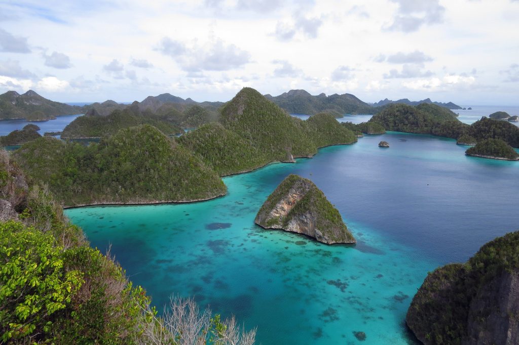
I then went for a snorkel at the jetty where were five 1.5m black tipped reef sharks were cruising between reef and shore. They were harmless, apparently, so I snorkeled after them and got some photos. Apparently they were always here as they were fed. It was cool to be swimming amongst them. In the late afternoon I thought I better take an exploratory tour in Wayag lagoon. It was just a couple of kilometres to the entrance. I decided to explore the east half and see if I could get round. It certainly was impressive with many karst citadels but I could see from the photo copied aerial images I was on the edge of it.

31. Arriving at the Ranger Station on Wayag Island where I was to spend the next two nights. There were about 10 rangers here who worked on weekly rotas

34B. The narrow passage throughj the island of Wayag from the lagoon to the north side was blocked by a wall of 2 metre breaking waves
I paddled north up the side of Wayag itself hoping to punch through the incoming tide see if there was a way round the north side. The sandy channel, full of corals, was crystal clear but it was a good 5 kmph southerly flood tide to battle with. I managed and then went into a side arm to the east. There was no current flowing in to it, so I suspected it was a cul de sac. It was but only by perhaps 20 metres or so but these were impassable with steep rock. I paddled out to the fast tidal stream again and then headed north to huge breakers crashing onto a reef. There was no way out through these 2.5 metre monsters and then it would be onto the exposed north coast anyway and I had had enough of that on Uranie. I took some photos of the violent surf and then returned down the fast flowing tidal stream over the crystal clear waters again. It was like a drift dive over the coral and I could see the reef fish scatter as my shadow appeared.

35. Having failed to paddle through to the passage on the north side of the archilelago I returned to the main lagoon and headed west into the heart of the dramatic scenery. Here I paddled over a shoal of fish.
I soon reached the entrance to the sea again, turned left and was back at the park office having a cold shower with half an hour. I was well set up in my little shelter and cooked noodles before crashing at 2100. The generator kept going until that time at least meaning I had enough light from the bulb above the tent. By and large everyone ignored me in the evening which was perfect.

Raja Ampat kayak. Day 10. 19 Feb 2016. Wayag 25 km. 6 hours. I slept well on my small covered platform with the breeze keeping me cool. When I got up at 0700 it was a great day and I was ready to go off and explore the lagoon and hopefully find the tracks. It was difficult to get any information on them as no one could read a map to point out where there were. All I knew is that there were 2 paths up two different towers. I set off eager to explore and with a light kayak. I initially crossed the two bays and then turned north into the lagoon. I headed straight up to a big mangrove fringed beach beneath a tall limestone spire. The tide was flooding and the water above the shallow sand was hot. I was looking for a place to climb but there was no sign.
Heading north in the huge convuluted lagoon of Wayag exploring the various passages between the towers and ridges. Here I was trying to find the routh out to the north
I decided to go anti clockwise round the perimeter of the lagoon. The walls to the north were quite narrow as I could hear the swell pounding the cliffs and corals on the other (north) side. About half way along I got distracted by an impressive set of spires and citadels rising straight out of the lagoon. I abandoned my circumnavigation of the perimeter and headed straight south over to them. They were some 100 m high and virtually sheer. There were about 20 of them all heavily undercut and totally impregnable. I paddled around their bases in awe, while at the same time looking for paths. A good hour later I was cruising the south side of them but still could not see any path despite covering every channel. I then end I ended up heading back to the large beach in front of the mangroves. I landed here to explore the sandy shore but there was no sign of a path. I now re-embarked on my anticlockwise circuit of the perimeter. It was impressive here too but my eye was drawn to the karst towers which previously distracted me. I continued round going into most nooks and crannies over the clear water with sands or corals below and steep bush clad karst above. I reached the west bay and then headed south and exited the lagoon into an outer lagoon.
36. On the second day I returned to the lagoon to paddle amongst the towers and search for an elusive route up one of the towers which was I knew existed but could not get information on its whereabouts
I saw a boat anchored up at a beach in the distance to the SW of this exit from the inner lagoon. After a kilometre I reached the boat. It was a bunch of Jakarta holidaymakers with 3 of the guides from the Rangers office where I was staying. The Indonesians said a path started right here and showed me the route. No one could help me out on the whereabouts of the second path though despite the Indonesians translating what the Papuans said. They Indonesians had already done the hike and were now just snorkeling and getting ready to pack up. I hauled my kayak up.

37. After many hours exploring I found by chance the route up a tower from the beach below. I was very steep with the occasional rope to haul up on. Here is the view looking west
I changed into my hiking boots and headed up. It was initially quite steep and then became very steep, almost scrambling really but there were excellent holds and trees to hold onto. After roughly 20 minutes I had climbed 100m and reached the top. What a view burst forth over the outer lagoons and the inner lagoon with the karst spires where I had previously circumnavigated the perimeter. It was a photo fest with inner and outer lagoons in all directions and from these rose karst ridges, pinnacles and towers from the blue green turquoise waters, depending if it was sand, coral or deeper water. I must have take 100 photos from this one spot. It was without question one of the top 5 views of my life. After enjoying the cooling breeze and taking in the beauty for a good half hour it was time to return. From this perch the route was clear. I should go west slightly to enter the outer lagoon on the south and then follow this back through towers and across coral and sand. In a few kilometres I should then reach my usual entry/exit point into the lagoon and then it was just the two bays back to the park office and my camp. I returned gingerly down the steep slope. A slip of this jagged karst would be a festering wound until treated and the salt water would make sure the pain was prolonged.
38. Here is the view from the tower looking east over the archipelago and Wayag Island beyond. One of the most incredible places I have ever been.
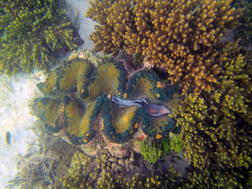
40. A giant clam just by the jetty at the Wayag Ranger Station. This one was about a metre long and filtered water through it body inhaling in in the shown intake valve and expelling it in an unseen valve to the left
Back at the kayak I did as planned and went via the outer south lagoon. I felt I had a good explore over the last two days here but I was still at a loss as to where the other path was, despite an extensive search. I was back at the park office some 7 hours after I left and there was still just time to swim with the Black Tipped Sharks. I noticed many of the 1.5-2 metre adults had a single small fish under them. I don’t know if this was a baby or a parasite fish. I think it was the latter. There were other fish in the corals here and also a few large clams I got some photos but the light was poor and the sand stirred up. A couple of the Papuans borrowed my kayak for a short spin in the bay while I got some fresh water and coffee in return from them. One of the Papuans now also explained to me roughly where the second path was a said it was impossible in a kayak as the overhangs would defeat me. I needed a large boat to step onto the top lip of the overhang. He said both paths were the same in magnificence. I crashed at 2100 with great memories of the day and also a tad of sun burn.

41. One of the Black Tipped Reef Sharks which was swimming in the bay off the Wayag Ranger Station. The sharks were apparently harmless despite being nearly 2 metres long
Raja Ampat Kayak. Day 11. 20 Feb 2016. Wayag to Palau Kave South Bay. 34 km. 6.5 hours. I woke up with a tour group of Jakarta professionals posing beside the kayak for selfies. They seemed amazed that I had paddled it here. They were off to Wayag lagoon. I decided to miss my second day at the lagoon as I had done all of it except the second trek. And this seemed too difficult to find and execute. There seemed to be a shift change at the park office with one crew returning with bundles of wood they cut to take back to Sarpele, while another 5-8 arrived, some from Salio. I packed up under the watchful eye of many of the new Papuans on shift and then set off at 1000.

33. The kayak on the beach by the ranger station at Wayag where I made base camp to explore the archipelago over the next 2 days
It was a glorious day as I paddled off over the black tipped reef sharks heading for the west corner of Palau Stephanie just a couple of km away. It was a beautiful island and the sheltered west and south sides were fringed with landable and camping beaches. Once past Palau Stephanie I made for a single islet in the middle of the Strait. I had hoped for wind and tide assistance but there seemed to be little tide and it was a calm still day. Frigate birds circled and then swooped en masse to where schools of aggressive tuna were chasing the smaller fish to the surface. It took just 2 hours to reach the islet, which was landable in these gentler seas.
However, just half an hour later I was approaching the beach on the NW side of Palau Kave, where there was a bit of surf. I continued south past the headland and into the Southern Hemisphere again. I was looking for a freshwater place Sony showed me on the map. I thought his directions were suspect but I could find no more information. Once past the headland I was into a huge bay. I had to paddle hard to get into the bay as the tide, against all my intuition, was ebbing north. Or was it perhaps flooding north from the Indian Ocean and this was causing my confusion. I crossed the bay with two beaches and went round another headland. Palau Kave was not limestone and as a consequence it was different with no undercutting. Apparently there was an abandoned nickel mine here and there were plenty of red scars on the hillside in this first large bay. I went round the second headland and into a deep bay.
There was plenty of green vegetation so perhaps there was a stream after all. I fantasised about wallowing in a cool freshwater pool. However when I landed at the beach I could see no sign of it. There was a stagnant mostly fresh pool beyond the beach but no freshwater. I went for a walk to explore. It was a godforsaken scene. The brackish pool was muddy and mud fish thrive around its periphery, jumping across the water when I approached. Further inland mangroves clogged the pool and pandanus palms with serrated edges lined the water and forest. I went some 300m into this primordial Jurassic scene but the water was foul. On my return I inadvertently knocked a rotten tree from which some 50 bees/wasps emerged. One stung me as I fled ready even to hurl myself into the foul water. I escaped though and after an intrepid hour was back at the kayak. I was not staying here nor drinking the water. If there ever was a perfect breeding ground for mosquitoes and the malaria they carry this was it.
I continued south into the next bay. It had the bamboo left from Papuan tarp shelters so I thought this must be the freshwater. But although it was freshwater it was muddy and covered by mangroves, I would not bath in it let alone drink it. So I carried on south. Round each headland the corals were stunning and the water so clear. I could see reef fish 10 m below me. I passed the penultimate beach on the west side and thought about going in but it looked like a sandy beach with malarial ponds, clogged with mangroves just behind the beach. There were no empty homestays anyway. After the final headland of crystal clear water and corals again I entered the southern bay on Palau Kave. It was a km deep so I paddled to the sunny beach at the end of the bay. The beach however was composed of broken bits of staghorn coral with no sand. It was also covered in jetsam of plastic and most uninviting. There was a creek beside it with the tide slowly entering it. I went up into another mangrove covered lagoon. The water tasted slightly brackish, if not sweet, but it was most unappealing.

42. The beach in the south bay on Kave Island had no fresh water for bathing, which I craved.
I returned down the west side of this southern bay where I noticed some horizontal bamboo for a Papuan camp. It was much nicer but had a stagnant lagoon behind it. I thought I could easily camp here. I am not surprised Palau Kave has no settlements as the lagoons must be infested with mosquito larvae. After setting up the tent and eating I watched an army of hermit crabs emerge from the sea and clamber over everything. Within an hour there were 10 on the stove alone. It was a peaceful night but I was well covered in insect repellent. I crashed at 2030 looking forward to a kiosk on Manyaifun tomorrow. My daily diet of freeze dried soya packets for breakfast and noodles for tea, all washed down with water, was Spartan.
Raja Ampat Kayak. Day 12. 21 Feb 2016. Palau Kave South Bay to Manyaifun. 32 km. 5.5 hours. I had a better night on Palau Kave than I anticipated and even woke up slightly cold at one point which was a luxury. I got up at 0800, had the usual dehydrated soya mince cottage pie for breakfast plus a litre of water and was packed and ready to go by 0930. The tide was still going out and not far from the lowest. I left the bay with herons scooping up the jumping sprats which the tuna were sending into a frenzy about like piranha fish. It was a very still day and I would not get the anticipated assisting breeze. However I was doing 5 plus kmph and that was ok.
It took a good 1.5 hours to get to the 2 small and one tiny islet. Here there was a stronger current but I think it was against me. Just beyond it was in my favour and the breeze kicked in also. I was doing up to 8 kmph and was flying along. Palau Bantanpele was still a long way off though, perhaps 20 kilometres. To keep myself amused I began playing games with the GPS and my average speed. I got it up to an average of 6 kmph and kept it there. It was quite easy with the following breeze and current which must have been in my favour. I was crossing the Selat Bouganville, the Bougainville Strait. I passed a log with about 6 sandwich terns sitting on it and also passed a couple of marlin leaping high into the air for 4 or 5 leaps at a time. I now reckon it was a marlin which hit my rudder on Palau Uranie a week ago. Where the current met still water or where there was an upwelling, tuna seemed to thrash about feeding on fry. The tuna would often leap into the air too. They were about 30 cm long.
Eventually after 4 hours and 24 km I finally pulled level with the island, called Palau Kodor, to the west of Palau Bantanpele. I followed its north coast over crystal clear waters perfect for snorkelling off the pristine beaches. At the end of this island I crossed the sound between Palau Bantanpele and the island to the south, called Pulau Manyaifun. The village of Manyaifun came into view and so did a couple of shacks, which looked like homestays. As I neared one I saw a red towel drying. It was on the inside of a small island with a graveyard on it. As I approached I saw a tourist and then another. I pulled onto the beach pleased with my efforts after 5 hours and 31 km.

43. The longboat at Sea Fans Homestay on Manyaifun Island where I stayed with 3 French, a Serb and a Russian for a night
There were 3 French tourists here, one of whom I had met before at Mandos homestay when I was ill with a cough. The homestay had a room free in one of the two shacks, the other guests liked it and they said the food was good. Great! How easy was this?. I carried the kayak up beside the lodge which overlooked the beach and rustic jetty and unpacked. I was in the other shack sharing it with two men, a Serb and a Russian, both of whom spoke English apparently, but were away at the moment with the homestay owner in a longboat snorkelling. Then I had a fresh water bucket shower and loved the luxury of soap lather. I washed some clothes and got into fresh ones.
44. The relative luxury of the shack which I shared with Sasha and Sergey. Here I ate fresh food and had a sweetwater shower
I went with the French into the village. I needed a sweet sugar drink and some spare batteries for the GPS, which I loved for the data it gave me about currents and speed. The half km walk to the village was half submerged by the tide. The village was a main concrete lane with perhaps 50 houses on each side. Most were concrete on the landward side and looked bare inside. On the sea side of the lane were mostly wooden shacks, many of which were fishermen’s enterprises with wooden longboats and empty stalls to sell wares. I walked back conscious of the fact that it hurt between my toes. Perhaps the sand rubbing has caused an infection.
I returned the half km to the bamboo shack on stilts over the water which was my luxury home for the night complete with mattress. I wrote the log as I watched the sun go down as I waited for supper which the French promised would be sumptuous. The Serb, Sasha, and Russian, Sergey, had now returned from their snorkelling trip and had swum with manta rays and dugongs. Sergey had two Gopro cameras, mounted to film in 3D and had some magnificent footage he showed us that evening.
Raja Ampat kayak. Day 13. 22 Feb 1016. Manyaifun to Yefnabi Kesil.14 km. 2.5 hours. The 3 French at the Sea Fans homestay by Manyaifun had arranged to spend the night on a small island south of the heavily coral fringed islands of Mangara and Miosarar, both of which had small villages with kiosks but no homestay. They said I was sure to see manta rays and invited me to camp there that night also. I eagerly accepted their invitation. I left Sea Fans homestay at 0900, paddled past the village (kampong) of Manyaifun, which seemed to be half Christian and half Muslim. I went round the small bump at the end of the island and then turned my back on Batang Pele island and headed south east.

45. A fisherman on a longboat beside Miosarar Island which I passed en route from Manyaifun to Yefnabi Kesil islands
I had aimed to poke my nose into a horseshoe shaped island with a coral lagoon in the middle of it called Palau Islap, en route to Yefnabi Kesil. I saw the islands as I turned southeast some 6-7 km away. I set my sights just west of the island with this lagoon but unfortunately ended up one to the west and ended up paddling down to Miosarar instead. I had already virtually passed the new Christian village on the Miosarar before I realised my mistake. The tide was very low and I had to make big detours for the coral reefs. I doubt I would have got into the lagoon on the island of Palau Islap further to the east. I had a good breeze and current and was blasting along at 7.5 kmph so decided to continue for another 5 km to Yefnabi Kesil. When I got there I noticed that Sasha and Sergey were already there. I chatted with them before I noticed a manta on the east side of this tiny island, not to be confused with the larger Yefnabi Besar which had a resort on it. We went into the water and I caught a fleeting view of it 10 m below the surface after Sasha pointed it out. I then swam round the entire island with Sergey who was filming much of it. They then left with their longboat and I had the island to myself. I swam round it again, quite leisurely, which took a good hour. The corals, especially the fans, were fantastic and so were the myriad of reef fish many of which I recognized from other parts of the world. I saw no mantas though.
49. Swimming with Sergey, the Russian photographer, around Yefnabi Kesil island we passed over a paradise of corals and fish
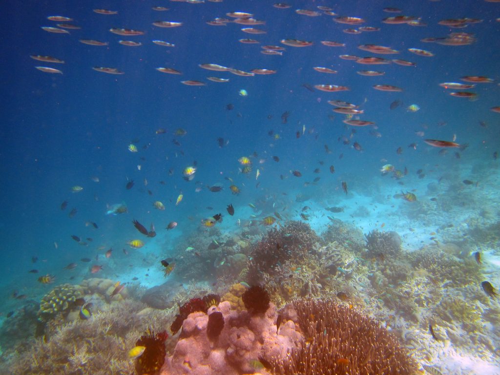
47. The sea around Yefnabi Island was teeming with corals and shoals of fish
After my swim I was tired and had a snooze in the shade on the beach. I woke at 1600 to the sound of an outboard with 2 Papuans and the 3 French. We greeted and then the Papuans showed me the best place to put up my tent, which I had already discovered. The others were keen to snorkel and by 1500 we were in the water with the longboat in attendance. Initially we were slow to see anything but then Andreas, a Papuan, started spotting manta rays and guided us over to them. Suddenly we were in the thick of them. I saw about 6 gliding past. They were huge and very graceful and about 3 metres across. We followed them and then other groups when Andreas, who was on the boat pointed to the direction they were in for them for a good hour until it dusk arrived. I was at a distinct disadvantage with no fins and a poor mask and baggy shirt to keep the sun off. That hour of swimming with them was one of the highlights of the trip so far.
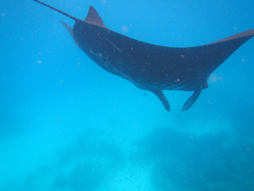
52, A near three metre manta ray gliding past me as I snorkelled amongst them. They were graceful filter feeders and completely harmless
In the evening I was tired after all the swimming and had to lie down on a bamboo mat by the fire while the 2 Papuans prepared a fish barbecue and fish. We had 4 large fish between the 6 0f us yet we only managed to eat one and I had half of that. It was a full moon over our islet with a nice sea breeze to keep us cool. We chatted for an hour until 2130 then we all crashed out. I liked the 3 French, who were all from outside France. Patrice and Mariepiere were from Reunion and Natalie was a Quebecoise. I would have slept well but was sunburnt on my legs and the sea breeze all but died so it was hot.

51. Andreas, who acted as lookout on the boat to spot the manta rays, preparing a meal for us in the evening on the small island of Yefnabi Kesil where I camped with the 3 French.
Raja Ampat kayak. Day 14. 23 Feb 2016. YefnabI Kesil to Piaynemo. 21 km. 4 hours. We woke early eager to get into the water and swim with the mantas. So much so that breakfast was forgotten. I initially thought the others went to the wrong spot to see the mantas, namely the NW coral and sand spur which headed off from the islet. I instead went in from the shore on the west hoping to get to the SW corner where we saw them yesterday. Unfortunately I had some 200 metres of shallow hot sandy coral to get over before I was in and 5 metres above the glorious sea fans and the kaleidoscope of fish. Unknown to me Natalie was shouting at me to come over as they had up to 6 mantas swimming around them for 20 minutes. By the time I got there they had gone.

48. There were perhaps a hundred different spieces of fish swimming in the corals around Yefnabi Island, some in very large shoals with thousands of individuals
I decided to stick with Andreas, the Papuan, and Natalie as they seemed to know what they were doing. Again, I was at a disadvantage with no fins and the poor mask especially with these two natural divers who could free dive 15 metres without any problem at all. We saw a few but I would struggle to keep up. Eventually Natalie took my camera and took some footage of 3-4 mantas and an eagle ray. We even saw sharks. Andreas suddenly alerted me to a manta which swam towards me and turned just a few metres away. It was the encounter I had been hoping for. Unfortunately Natalie had the camera. After 1.5 hours swimming and 5-6 manta encounters for me I headed back in. By now Sasha and Sergey had arrived and were already snorkelling somewhere. The French wanted to get going to another place so we said our goodbyes and I started to pack.

54. An eagle ray which Natalie, one of the free diving Fench, took when I lent her my camera. It was about 15 metres deep and too much for me to dive down to.
I left at 1000 and at the first stroke realised how hungry I was. I thought I could manage a few hours. I left and went anticlockwise round the island to where the mantas were yesterday on about SW of the island. As I approached I saw the calm sea was alive with mantas. There were at least 20 of them, wingtips breaking the surface and their massive bodies causing bow waves. I paddled into the midst of them and they seemed largely unperturbed. I noticed Sasha was snorkelling in the thick of them and he must have had some 20 circling, diving and surfacing around him. He was in the dream position. I stayed still while they circled around me, also putting my camera in the water as they almost brushed the kayak and entirely filled the photo. Eventually I drifted over to Sacha and we shared our wonderment before saying goodbye for the third time.

53. The near metre wide mouth of a manta ray swimming towards me as I snorkelled in a pod of about 6 of them. They gracefully veered to the side to avoid a collision with me
I then turned SW and aimed for the north tip of Fam Besar some 15 km away. They crossing was easy, but not a good one. It was hot, I was tired and my shoulder was sore. In addition the rudder was not working well. Just short of 3 hours I made landfall on a sheltered beach on the north of Fam Besar. There was a group of Muslim Papuans here. The men were prizing clams from the sea with a screwdriver while the women, who were large and in burkas, all greeted me with the red lips and gums of beetle nut chewers. They were a formidable sight. I left after 10 minutes and headed south down the east of the rocky island for a few kilometres before I got to the entrance of Piaynemo lagoon. I paddled into to this mini version of Wayag.

55. The homestead at Piaynemo on the island of Fam Besir where I stayed for 2 nights was in a very spectacular archipelago
At the end of the lagoon was Piaynemo homestay. It looked like I was the only guest. I was greeted with such apathy it was obvious they had no concept of hospitality. Everything was a problem and they had no food. Eventually I got a room and hauled the kayak up and unpacked. I was then given a coffee. Things improved quickly and I had a cooling shower and then sat down to write. Half way through at 1700 I was given my supper of rice and a tuna omelette. Everyone seemed to be shuffling around in a dream. One older guy was ambling about with no particular aim. He came and spoke to me in perfect English. He was the owner and had been a foreman for Conoco for 30 years constructing oil rigs. The other two people loafing around were his son in law and nephew. At least I knew who to go to get things done. He was 65 but did not look it. A few dinghies came and went taking punters around the lagoon and up to viewpoints in the dusk but I was beaten by the sun and swimming to have any energy left over for anything other than an early night. Besides, I had a free day here tomorrow.
Raja Ampat Kayak. Day 15. 24 Feb 2016. Piaynemo to Piaynemo. 14 km. 3 hours. I had a great sleep in the breezy room and was up at 0700. However, I felt lazy and my plans to paddle round Fam and the islands to the south were soon shelved in favour of a more local day. First I had a couple of coffees sweetened with condensed milk. The breakfast I was served by the owner’s son was five fistfuls of dough fried in oil. I took a bite of one ball and put it aside. I then prepared some instant noodles in my pot and asked them for some boiled water. He seemed upset at this but, it did the trick and from now on food was great.
After the noodles I chatted to the owner, Airlie, for a good hour. He was a wise man and I liked him a lot. His son and nephew fished for sardines in the mangroves below foul hooking one every cast after a few seconds. Once he caught a black tipped reef shark and put it back. Airlie had been a construction manager and understudy to an American who he viewed as a brother. Airlie talked to me about the imperialist ambitions of Indonesia and were it not for Australia administrating PNG then Indonesia would have probably overrun this country also. A few speedboats with Indonesians came to the pier, looked around and then went off to the 5 sided lagoon. I had a snooze and at 1300 was woken to be served 2 large fish and rice. I had no idea it was coming. I could only manage the smaller fish. Then 2 more boats with divers came in to use the place for lunch and as a toilet stop. They were mixed groups with some Europeans.
I decided I would paddle around the lagoon and then the south half of the island. I launched off the jetty steps and then explored a couple of nooks and crannies hidden by small passages. The rock here was karst and heinously sharp. I looked at the one walk you could see from homestay but it was low tide and the landing was too difficult. So I carried on round to the walk with the 300 odd wooden steps. The landing here was easy but there were some 5 boats already there, most of them dive boats. I tied up to the outer one and clambered over 2 to get to the jetty. It was clogged with Papuans selling souvenirs and drinks, coconuts and even crabs. There must have been at least 10 stalls, probably all from the village in the Fam archipelago, just south of Piaynemo. The walk up was easy and the steps barely 15cm so it was just a 50m climb. The view was well worth it. I have heard it described as mini Wayag and it was a bit like that. However, with the business and the small hut built in the middle of the view to collect ticket money it did not have the wow factor Wayag had.

56. The Piaynemo archipelago on the island of Palau Penem in the Fam islands. It was like a small version of Wayag
I was back in the kayak in a jiff and then started my trip round the south half of the island of Piaynemo. Much of the east side was bounded by a coral reef and I chose to go inside the coral in the lagoon, being careful not to hit anything. There were a few bays with what looked like abandoned homestays. At one it seemed the beaches on each side of the island met, creating an isthmus similar to the one Piaynemo homestay. In fact the island was about 4 humps connected by 3 isthmuses. There was a good northerly force 4 pushing me to the south tip of the island which seemed to go on longer than I thought. There were also a couple of nice beaches on the south side which was longer than I expected. Up the west side I had to paddle hard into the wind and perhaps the incoming tide to make good progress to reach the first isthmus. Here I found shelter up the coast to go round a bumpy headland to reach the bay of the second isthmus where my homestay was.
As I pulled into the beach the chef came to greet me. I did an Eskimo roll for him when he asked what I would do if I capsized. I landed at the toilets and we carried the empty kayak some 50 metres to the east side jetty to complete the loop of the southern half. After a brackish shower I wrote the blog while sipping fizzy drinks Airlie had got from a kiosk. I listened to the waves of airborne sardine shoals splashing back into the water as they were being chased and hunted but the 0.5m black tipped reef sharks. Herons perched on the roots of mangroves hoping to snatch a fish as they panicked with some leaping into the air.
Raja Ampat Kayak. Day 16. 25 Feb 2016. Piaynemo to Arborek. 29 km. 5.5 hours. This was to be my last biggish crossing of the trip. It was some 28 km directly to Arborek, a bit longer if I detoured via Palau Janggelo on the west tip of Palau Gam. The winds had been up for the last few days so I was anxious for an early start. I was up at 0630 and packed by 0700. Then after an early breakfast I said goodbye to my host Airlie and left by 0730. It was a short paddle out of the lagoon, across the gap to a small archipelago east of the lagoon and out into the Dampier Strait. The wind must have almost been a force 4 from the north. I set my sight on the distant Palau Janggelo some 20 km to the east in the blue haze.
After a couple of km the wind eased to a low force 3 and I cruised along at nearly 6 kmph. The falling tide did not seem to produce an easterly current as Airlie had said it would. It took a while to get anywhere near half way and Janggelo seemed to keep its distance. There was nothing for it but to keep plugging on km after km. Again I played games with the GPS regarding my times and averages. Occasionally a marlin would do multiple leaps in the distance creating splashes. They must have been well over 100 kg, perhaps even 200kg. At one stage I saw a fin nearby. I then realised it was the sail of the dorsal fin of a marlin some 40 metres away. It was just swimming about the surface. Then it was back to the relentless pull towards Janggelo.
About 3 km before Janggelo I decided to head straight to Arborek. I had been paddling for 3 hours and had done 17 km. I reckoned Arborek was another 10 km or 2 hours. However the tide was not helping at all and a squall got up with heavy showers on Gam and then Mansuar islands. Even the flat Arborek just about vanished from view and my speed was down to 4 kmph. It did take the other 2 hours plus more to reach this tiny island. I did not know what to expect at all other than it had some 5 homestays. The water was low with large reefs exposed on the SW and NW sides. I paddled round to a busy jetty with a few small dive boats tied up and a few liveaboards in the bay to the north of the jetty. I then noticed many local longboats on the beaches above the exposed coral fringe. I paddled under the jetty and landed at a small beach and went up.

57. One of the homestays on the island of Arborek. The island was quite busy with a handful of homestays, a small shop and a few diving businesses
It seemed Arborek was actually a largish village with some 50 houses. I wondered about and found a few homestays but only one, Lalosi, which I liked the look of. The tide was still too low to paddle round to this side so I took what I needed from the kayak and walked across the small island. It was about 1400 hrs now and it was the heat of the day so I went for a tour round the rest of the island which was just 500m long and 250 metres wide. There were men cutting up large barracuda with machetes. Presumably for the homestays, although 3 seemed empty, and to feed the dive liveaboards.
I had a load of emails to attend to and then wrote the blog until the sun went down. I phoned Tertius in the afternoon and he said Sandy Robson and Justine Curgenven would be at Mandos homestay in a couple of day’s time when I planned to finish. They were two of the world’s top expedition paddlers and it would have been an honour to meet them. Sandy had actually paddled here to Indonesia from Germany and was en route to Australia!
Raja Ampat Kayak. Day 17. 26 Feb 2016. Arborek rest day. 0 km. 0 hours. I felt lazy when I woke up and I only had some 25 km to go and 3 days to do it in. I thought I might have a rest day and do some snorkelling. First off, after the dire breakfast which earned the homestay owner a complaint was to find out about diving. Some French were going and it was about £30 for a mornings hours dive. Trouble is I did not like the sound of the dive site as it was sandy rather than corals. But this was good for mantas, it was explained. I decided to give it a miss.
Instead I bought 15 poor quality razors and started to get rid of my beard. I did not stop there and soon started on my scalp also. Unfortunately I could not see what I was doing and made a mess of it and by now had clogged all the razors up. I had to abandon it and get the teenage boy from the homestay to get scissors and dry shave me to finish the job. In all the whole shaving operation took 2 hours. By this time it was too late to launch the kayak as the reef had appeared and it was a bit too hot to snorkel. Instead I lazed around in the shade drinking coffee. By mid afternoon I was ready for a snooze and slept on a bamboo bed in the shade. I was woken by heavy rain but as I had nothing in my pockets just stayed put and enjoyed the cooling refreshing water. The rain finished and the water evaporated quickly.
I then got a phone call from Tertius to say that Sandy Robson and Justine Curgenven were arriving on Arborek sometime in the afternoon and were staying at Indip homestay. I went round to meet them but they were not there at 1500. I went back at 1700 and they had just arrived. I helped them up with their kayaks and then said I would return at 1900 when they had showered and sorted themselves out. I returned to my homestay, wrote up the blog and told the German couple also staying there that I would be back at 2100 and keep food for me. When I went back to Sandy and Justine they were tired, especially Justine who was floored by today’s sun. However, they soon started chatting.
Sandy was soon holding court being prompted by questions from me. In short she was following the 7 year kayak odyssey of Oskar Speck who started from Ulm in Bavaria in 1932 and arrived in Australia in 1939 just in time to be interred for the duration of the Second World War. Sandy had likewise started in Ulm, gone down the Danube into the Aegean and to Lebanon via the Turkish coast. Oskar Speck then went through Syria and down the Euphrates and Shat al Arab waterway to the Iranian and Pakistani coasts. Sandy could not do this safely as a woman on her own. She almost had permission for the Iranian coast, but it was then withdrawn so she went from Lebanon to India. There she paddled down to Sri Lanka, and went round Sri Lanka to boot. She was the first person to do so in a kayak. Thereafter up to the Myanmar border. Her permission was denied except for the Myeik archipelago in the south where she resumed. Since there she paddled everything to West Papua bar the odd 100 km Indonesian island crossing where she took 3 ferries. She had a multitude of stories to tell like having Indian Special Forces leap from a helicopter into water beside her and having a white lipped viper in her cockpit in the morning.
I could see Justine struggling to keep awake and she looked beat by the sun. She complained about the stuffiness of her tent so I offered to lend her mine. It was easy to warm to Justine and be amazed by Sandy’s stories and feats. Although Justine certainly had a few epics in her time. These two were probably in the top 5 sea kayakers in the world. I returned to my homestay at 2130, and the meal was still there.
Raja Ampat Kayak. Day 18. 27 Feb 2016. Arborek to Yendebabo Beach. 31 km. 5.5 hours. After breakfast Justine came round and we put the tent up. She was feeling a lot better and we chatted enthusiastically. She liked the airiness of my tent and we agreed to swap in Seporkreng tomorrow. We chatted for a good hour before Justine thought she better return. I packed up, said my goodbyes to the Lalosi homestay staff and then launched at 0930. My route took me back north across the strait to the entrance to Besir Bay. It was 8 km.
I had to pass over an enormous coral reef, some 4 km long and 2 wide. The falling tide was swirling round it causing some currents. By and large I could paddle over it and look down at the platform of corals perhaps a metre below me. A lot of it was dead and bleached and it would soon be exposed to the bare sun once the tide fell further. However, around the edges and in lagoons inside this plateau were rich coral areas which remained submerged and here you could see large sea fans and plenty of fish. I dare say these would be excellent spots for diving and snorkelling, notwithstanding the tidal currents. Past this coral it was another few kilometres to the east lip of Besir Bay. As I went in I passed a cluster of karst islands with beaches between. There seemed to be a homestay here. I went in to check it out and noticed the Germans were here. It looked nice. I wanted to go and paddle in the SE part of Besir bay so I ordered lunch in 1.5 hours time and headed off. It was a very convoluted coastline with plenty of karst islands. However after Kali Raja in Kabui bay it was not that spectacular. I returned to the homestay for lunch with the Germans and then said goodbyes again.
58. Going up the channel by the eastern entrance to Beser Bay to the homestay where I pre-ordered lunch. Afterwards I went into the Jellyfush Lagoon to explore its warm waters surrounded by mangroves.
Initially I went into a kilometre long lagoon called Jellyfish Lagoon. It was shallow, ringed by mangroves and was warm. It thought it was the perfect breeding ground for dangerous jellyfish and crocodiles and wondered what I was doing in here. There was a longboat of tourists who were covered in suits and were snorkelling in one netted off area. I had to retrace my steps to the homestay and then go round the long way to get into the Dampier Strait again as all exits from the lagoon were blocked by corals at the low tide. Once in the Dampier Strait I headed south past a village with a huge jetty and then turned east. There was another village here with an even bigger jetty which a few tourist boats were tied up too. It seemed as if it were a day trip mecca and the houses on the jetty were selling souvenirs. I paddled past at 7 kmph with the wind in my back. I paddled past another smaller village and then a posh resort called Papuan Explorers which seemed mostly geared towards divers.

61. Another one of the rustic homestays on Yendebabo beach. This one was called Kordiris Homestay and was quite simple with a few sleeping shacks on the beach and a lodge built on stilts over the water for dining in.
The wind was still in my back but surprisingly I noticed there was a current with me too. Perhaps the tide was flooding again. If I went a few hundred metres offshore I was getting up to 9 kmph paddling normally. I rushed past a headland, past the southern entrance to the Bluewater Mangroves and then reached Yendebabo beach guarded by its 5 islets. The homestay I was looking for was Tauyado and it was towards the east end of the beach. The homestay was simple but the host made a real effort with soap in the shower and apples in the fruit bowl. There was a South African couple here also who had rented kayaks and were doing a smaller trip. They were good company. I got a message from Justine saying Sandy’s wrist was sore and she wanted a rest day so we would not meet up tomorrow after all. I made an arrangement to leave my tent at Mandos homestay for her. I wrote most of the blog and then had a great sleep.
Raja Ampat Kayak. Day 19. 28 Feb 2016. Yendebabo Beach to Seporkreng. 16 km. 3.5 hours. I had a slower start and then went snorkelling after breakfast. I just went straight out from the homestay across the sea grass then the fragments of tidally exposed corals until I reached the fringe of the reef which gently sloped down in an abundance of colourful corals teeming with fish. I snorkelled for about an hour before returning to the homestay and getting into my kayak.

59. Sorkelling off the beach by the Tau Yado Homestay on Yendrbabo Beach was a magnificent and easy site with a rich variety of corals and large shoals of tropical fish
I initially retraced my steps for a good km to reach the south entrance to the Bluewater Mangrove lagoon. The water was ebbing out of it so all I had to do was paddle against a small current to find the way through the network of mangrove lined channels. The water was about a metre deep and crystal clear. After 2 km the channels led into a large lagoon some 3 km long and a km wide. The water was more of a murky green here and I could not see the bottom. I paddled to the far end, the east end, where I found the channel which led for a kilometre to the sea again. Again here the water was crystal clear and the bottom was covered in coral. As the flow was ebbing it did not take long to reach the sea.

60. A typical longboat which is used all over Raja Ampat as the main means of travel. Ths one was at Tau Yado Homestay
Once I flowed into the sea I found myself near the Island of Friwen, which was quite small, very tropical looking, and had a couple of homestays or small resorts on it. I paddled up the coast towards it and past a lovely looking village called Yenbeser. Here I paddled up the shore looking at the fishing boats and village activity keeping inside the reef and current until I noticed 4 dolphins feeding the other side of the reef. By the time I got to them they disappeared. I then only had another km of kayaking before crossing the mouth of Kabui Bay to reach Seporkreng. In fact I could see Mandos homestay. The crossing was about 5 kilometres but with the following wind it was quite quick and before I knew it I had approached the karst islet at the west end of the beach. I cruised down along the village towards Mandos and landed at the freshwater spring here.

62. Passing the peaceful village of Yenbeser on my way back to Mandos Homestay at Saporkreng on my final day.
Tertius came to meet me and we soon emptied the kayak, flushed out the sand and then stored the kayak on the rack. It was some 430 km and 19 days since I removed the kayak from the rack. I spent the next few hours chatting with Tertius, rinsing gear under the shower on the jetty walkway and just spent time standing under it enjoying the cool fresh water cascading over me. Once this was done I spent the rest of the evening and dinner chatting with Tertius. We chatted about the kayaks, the guides and the whole project, which essentially was a development project and was non-profit. It was all very commendable. The whole thing was essentially the brainchild of Max Ammer. A Seventh Day Adventist who introduced tourism to Raja Ampat. He set up Papuan Divers on Kri Island and Kayak4conservation, both to be run sustainably using the local population. Tertius now runs the kayak project. Tertius had really been extremely helpful in organising my paddle here and without him I doubt all the pieces to make it successful would have come together. The three week trip was exactly as I had hoped it would be if not better.

63, Returning to the homely Mandos Homestay at Saporkreng after 3 weeks with 430 kilometres paddlinmg behind me since I left it. Here I met the very helpful Tertius again who was based here for the season managing Kayak4Conservation
After a day relaxing at Mandos I took the ferry from Waisai on Waigeo Island back to Sorong on the Papua mainland. I had to spend the night here before beginning the series of 5 flights to get home. On the way home I had the absolutely shocking news that Sergey the Russian who I had shared the shack with at Sea Fans Homestay and gone snorkelling with on the small island of Yefnabi Kesil had been killed. He had gone on his own to snorkel and film among the mangroves on the south side of Manyaifun Island in a seldom visited bay and had been attacked and mauled by a large 4 metre saltwater crocodile. It was thought the crocodile was defending its territory and viewed Sergey as a threat.