Sarek Ski 2023 / Gallery
-

- 01. Day 01. Heading south across Akkajaure Lake from Ritsem to Akkastugorna with the pulk loaded with its 60 kg including 12 days of food.
-

- 02. Day 01. The beautiful and graceful Ahkka massif is on the south side of Akkajaure lake and near the Akkastugorna cabin. Here it is in the late afternoon sun.
-

- 03. Day 01. The Northern Lights between the birch trees above Akkastugorna cabin on a very cold night of minus 25 C
-

- 04. Day 02. Leaving Akkastugorna with the short cut to Ruohtesvagge through Sjnjuvtjudisjavrasj looking tempting as it was 10 km shorter than the detour via Kutjaure lake and Kisuris. However there were steep banks to negotiate with the pulk.
-

- 05. Day 02. Looking SE across the open outflow of Kutjaure lake down towards Nijak and the start of Ruohtesvagge where I would camp.
-

- 06. Day 02. A mountain hare (Lepus timidus) in the birch woods near the cabin near Kisuris cabin.
-

- 07. Day 02. Heading up the frozen Sjnjuvtjudisjåhkå streambed near the treeline at 700m between Kisuris and the mountain of Nijak
-

- 08. Day 02. The steep north buttress of Nijak, 1922m, marks the NW point of the near 25km long Sarek massif. Ruohtesvagge goes up to the right of the photo.
-

- 09. Day 03. Early morning at my camp near Nijak after a cold night. Ruohtesvagge valley goes up to the right.
-

- 10. Day 03. Looking north to Ahkka Stortoppen, 2015m, from the northern end of Ruohtesvagge valley. The top is to the left of a small notch which has a small narrow very exposed apex of rock to straddle for 5 metres if coming from the right (east)
-

- 11. Day 03. Heading up Ruohtesvagge valley looking south to Boajsatjåhkkå. It is a great side trip up and over the saddle to the right of the mountain with great views to the right ( south) up the glacier into the heart of the Ruohtes massif.
-

- 12. Day 03. The snowy bitterly cold inside of the abandoned reindeer herders hut in Ruohtesvagge where I spent a night. Except for the fact I could sit and write I would have been warmer in the tent.
-

- 13. Day 03. The single Finn I met in Ruohtesvagge heading south to Mikkastugan with Mihkatjåhkkå, 1735m, in the background.
-

- 14. Day 04. Leaving the abandoned reindeer herders cabin in Ruohtesvagge after a bitterly cold night around minus 30 spent inside.
-

- 15. Day 04. Looking SW into the heart of the modest Ruohtes massif from Ruohtesvagge valley.
-

- 16. Day 04. Heading SE down the large arterial Ruohtesvagge valley towards Mikkastugan with Mihkatjåhkkå on the left.
-

- 17. Day 04. Looking NW back up the arterial Ruohtesvagge valley from near Mikkastugan with the pointed Gavabakte, 1906m, dominating the Sarek massif on the right (north)
-

- 18. Day 04. The highest mountains in the Sarek massif are Sarektjåhkkå Stortoppen, 2089m, (centre) and Sydtoppen, 2023m (right).
-

- 19. Day 04. Sarektjåhkkå Stortoppen, 2089m, in the evening sun from Mikkastugan. I hoped to go up the west ridge ( left) the next day from the unseen glaciated saddle.
-

- 20. Day 04. Mikkastugan is a small uninsulated shed in the middle of Sarek National Park. It is just big enough to sleep in and has a table and emergency phone. It was to be my basecamp for 2 nights.
-

- 21. Day 04. Inside Mikkastugan shed with the emergency phone in red by the door and my stove making a futile effort to stave off the minus 33 that night.
-

- 22. Day 05. Heading up the Mihkajiegna glacier on old tracks to the saddle ahead where the climbing starts.
-

- 23. Day 05. On the saddle between to glaciers looming up at the west ridge of Sarektjåhkkå Stortoppen. The route goes up the steeper ridge initially then eases off for the final section to the summit.
-

- 24. Day 05. Heading up the steeper, quite exposed west ridge of Sarektjåhkkå Stortoppen which at times felt like 45 degrees.
-

- 25. Day 05. Looking back down the steeper lower section of the west ridge of Sarektjåhkkå Stortoppen to the glaciated saddle below and my just visible tracks.
-

- 26. Day 05. The final steeper part of the lower section of the west ridge of Sarektjåhkkå Stortoppen before the gradient eased.
-

- 27. Day 05. The final shallower summit ridge of Sarektjåhkkå Stortoppen took half and hour of lofty hiking to the small conical summit, 2089m.
-

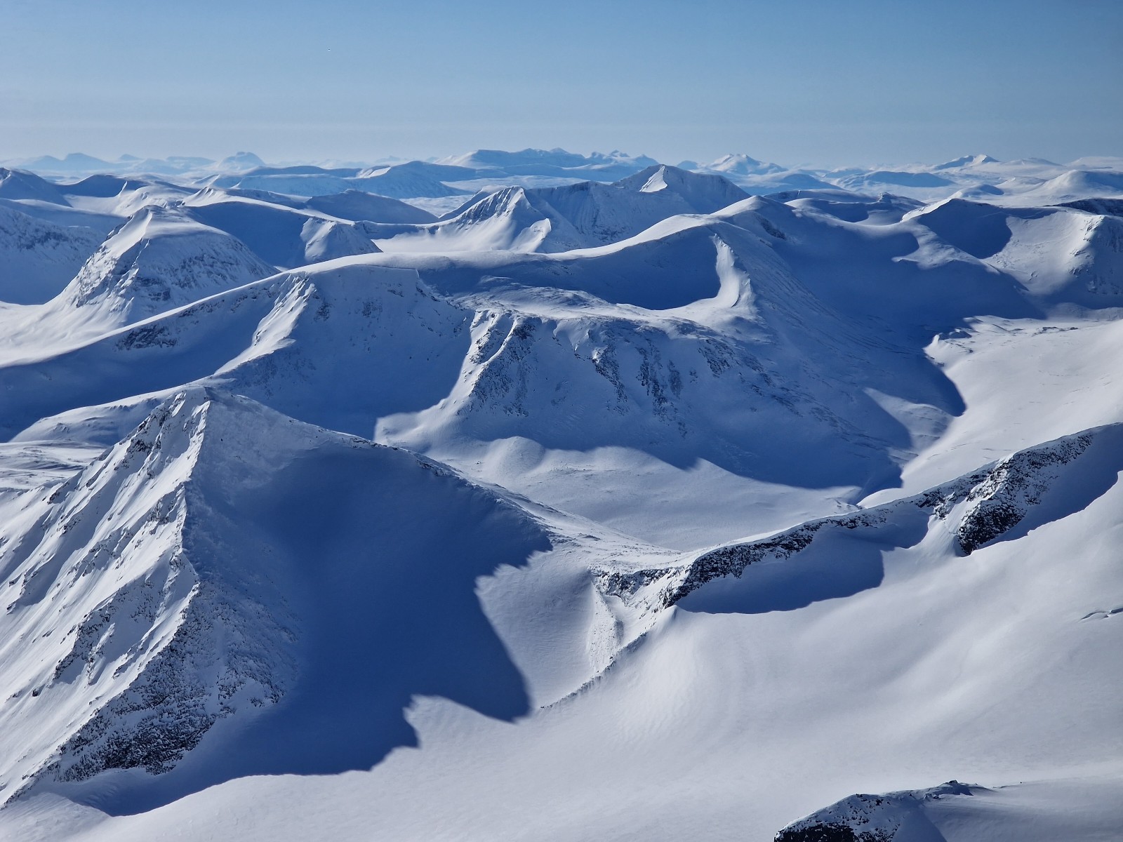
- 28. Day 05. Looking NNE from the summit of Sarektjåhkkå towards the Ahkka massif some 25 kilometres away.
-

- 29. Day 05. Looking SSE from the summit of Sarektjåhkkå towards Buchttoppen, 2010m, and the Skårki massif in the distance.
-
- 30. Day 05. Looking NW from Sarektjåhkkå over the Mihkajiegna glacier I came up to Vargtoppen, 1807m, Gassatjåhkkå, 1912m, and the rest of the Sarek massif.
-

- 31. Day 05. Looking south from Sarektjåhkkå Stortoppen to Sarektjåhkkå Sydtoppen, 2023m, just 500 metres away along the arete. In the distance are the Bielloriehppe (left) and Pårte (right) massifs.
-

- 32. Day 05. Looking SW from Sarektjåhkkå Stortoppen down the couloir which leads to Mihkajiegna glacier. It was the way I descended.
-

- 33. Day 05. Looking NE from the summit of Sarektjåhkkå Stortoppen to the Nordtoppen, 2056m. There is a sensational arete connecting the main top to the Nordtoppen.
-

- 34. Day 05. Looking NW from the summit of Sarektjåhkkå Stortoppen with a view down the west ridge to the glaciated saddle I came up from.
-

- 35. Day 05. Looking south from Sarektjåhkkå Stortoppen towards the Pårte massif across the deep unseen cleft of Sarvesvagge. These mountains are perhaps 20-30 km away.
-

- 36. Day 05. Looking east from Sarektjåhkkå Stortoppen down the crevassed Gaskka Sarekjiegna glacier.
-

- 37. Day 05. Looking NE along the sensational arete between Sarektjåhkkå Stortoppen and Nordtoppen from the former. The 600m passage involves some exposed scrambling or easy climbing in the summer.
-

- 38. Day 05. Looking NW from Sarektjåhkkå Stortoppen over the Alep Sarekjiegna glacier and the north facing side of the Sarek massif.
-

- 39. Day 05. Looking west from Sarektjåhkkå Stortoppen over the Mihkajiegna glacier and the south facing side of the Sarek massif.
-

- 40. Day 05. Descending the Mihkajiegna glacier towards Mikkastugan and looking up a accumulation bowl to the east beneath the impressive peak of Svarta Spetsen, 1842m. Note the wind formed “vindgryte” with the huge snow cliffs.
-

- 41. Day 06. Leaving Mikkastugan and heading west up Guohpervagge to its confluence with Alggavagge. The two valleys are separated by the long ridge of Harrabakte, 1704m ( centre).
-

- 42. Day 06. The small reindeer herders cabin in Guohpervagge at the confluence with Alggavagge ( on the left). These sparse cabins are used during the summer months by the Sami during various herding tasks, such as marking and culling.
-

- 43. Day 06. A last look back to the Sarek massif (distant left) from the watershed in Alggavagge valley as I start the imperceptible descent to Alggajavrre Lake and Alkavare Kapell.
-

- 44. Day 06. Alkavare Kapell is a very remote chapel used by the the now Christian Sami reindeer herders who come here in the summer. It was recently restored and with the roof in good shape I had high hopes to spend the night inside.
-

- 45. Day 06. The interior of Alkavare Kapell was completely full of snow which had blown through the stone wall as spindrift during the winter storms. “The Lord giveth and the Lord taketh away”
-

- 46. Day 06. I camped beside the Alkavare Kapell in great weather as the chapel itself was full of snow.
-

- 47. Day 07. In the morning after my night camped beside Alkavare Kapell the good weather had broken and there was a gentle snow shower and very limited visibility.
-

- 48. Day 07. As the day progressed I headed south and then east into appalling visibility and an increasing wind, and at time could see nothing except whiteness – like scuba diving in milk.
-

- 49. Day 07. After a trying 13 km I finally threw in the towel and camped some 4 km to the west of the watershed in Sarvesvagge, which it had been my intention to go over.
-

- 50. Day 08. I was stormbound in the tent all day as a blizzard raged outside. I was fortunate to have such a solid tent; a Helsport Patagonia 3. My pulk is just visible to the left of the tent.
-

- 51. Day 08. Although there was a small storm outside the tent held up well and I managed to keep quite cosy in my sleeping bags and caught up with the office work ofcthe blog from my chaise longue thermarest.
-

- 52. Day 09. I had to dig the tent out of a drift in the morning after the storm when it was windstill. The pulk was buried under a metre of snow. The visibility was poor but not appalling so I decided to make a break from the watershed in Sarvesvagge.
-

- 53. Day 09. Within an hour of setting off the wind had increased from Force 1 to Force 10 and as I crossed the watershed the visibility was appalling, especially in the gusts, one of which had the pulk airborne and me yanked round onto the deck, breaking a drag stay for the pulk.
-

- 54. Day 09. The further east I got down Sarvesvagge the better the weather got so after midday it was increasingly pleasant.
-

- 55. Day 09. As I approached Rovdjurstorget (predators meeting place) where Sarvesvagge met Rapadalen the wind ceased, the sun came out and the barometer shot up.
-

- 56. Day 09. Looking back up Sarvesvagge valley from the junction with Rapadalen. The watershed, where I had taken such a battering, was 17-18 km behind me now.
-

- 57. Day 09. My tranquil campsite beside the open, braided river valley near Rovdjurstorget in the upper part of the delta and lagoon area of Rapaselet.
-

- 58. Day 10. Skiing across the Bielloriehppjavrre lagoon in Upper Rapaselet looking NE to the Skårki massif.
-

- 59. Day 10. Looking back up Rapaselet with the Bielloriehppe massif on the left and Skårki massif on the right. The winters wind had stripped the snow off some of the ice in the delta land.
-

- 60. Day 10. Looking from the delta land of lower Rapaselet in Rapadalen up towards the steep and intimidating mountains of the Bielloriehppe massif.
-

- 61. Day 10. Heading down Rapadalen towards Alep and Lulep Spadnek (centre). I stopped for lunch here on a levee formed by the River Rapatno.
-

- 62. Day 10. A chance meeting with Geoffroy (left) and his team from Belgium. I had met Geoffroy 3 years ago and he gave me some Old Amsterdam cheese which he did again now to create a tradition.
-

- 63. Day 10. Near the 2 hard Rock knolls of Alep and Lulep Spadnek the Rapatno river fell more rapidly and I had to divert into the woods on the south side to avoid obstacles. Luckily I could follow Geoffroy’s tracks.
-

- 64. Day 10. Approaching Nammasj, a Nunatak in the middle of the Rapadalen valley. After Nammasj the Rapatno river entered a 7 km long detla, hemmed in by Skierffe (left) and Tjahkelij (out of pic on right) to spill into Laitaure lake.
-

- 65. Day 11. My campsite beneath Nammasj was blessed by the morning sun which soon banished the minus 20 chill of the night. The craggy hill in the background is Ridok.
-

- 66. Day 11. A last look up Rapadalen to the large convoluted Bielloriehppe massif bathed in the morning sun.
-

- 67. Day 11. The south face of Skierffe, 1183m, towered above the delta landscape of the Rapatno river as it entered Laitaure lake at 497 metres. The 300-350 metre cliffs were vertical.
-

- 68. Day 11. Beneath Skierffe, on the shore of the Sajvva lagoon I came across this Sami Kåta. They are traditional turf shelters use for brief periods during the year for a few weeks at a time. This one like most had a stove.
-

- 69. Day 11. The fabled homestead at Aktse belongs to the Lanta family. They are Sami who gave up their reindeer over 100 years ago to farm on the fertile ground.
-

- 70. Day 11. The STF huts are largely built on a design by Abrahamson. There are 2 such room which Mitton image each other. Each room has a stove, cooking facilities and two 5 bed cubicles for sleeping. This 50 plus year old design is great for getting the occupants to chat and work together until the candles get blown out around 2100.
-

- 71. Day 12. I had a day off at Aktse washing my clothes and myself during the day before the next intake of skiers and dog sledders arrived. That evening was exceptionally sociable with 3 great teams of other people and me.
-

- 72. Day 13. Crossing Laitaure lake en route between Aktse and Pårte cabins and looking NW towards Rapadalen with Tjahkelij on the left, Nammasj in the middle and Skierffe on the right.
-

- 73. Day 13. Skiing through the beautiful warm mixed spruce and pine woods in the vicinity of Lake Rittak near the delightful Pårte cabin.
-

- 74. Day 13. Me standing in from of Pårte cabin, also an 50 years old plus Abrahamson design cabin within touching distance of a razor at Kvikkjokk tomorrow. This photo re enacts one I took in 1986!
-

- 75. Day 14. Skiing across Stour Dahta lake between Pårte cabin and Kvikkjokk with the sharp spires of the taiga like spruce lining the shore and the large Pårte massif, which has two 2000m mountains in in a a host of glaciers.
-

- 76. Day 14. The last few kilometres to Kvikkjokk are an absolute delight as the mixed ski and snow scooter trail zips down through the mixed spruce and fir forest with some exciting sections.
-

- 77. Day 14. After 14 days and over 200 km of a magnificent ski trip, more of an expedition really, I finally glided under the archway of Kvikkjokk Fjallstation to some culinary treats and a fist shower since leaving Ritsem.