Shetland Kayak Eastern Seaboard

This Section follows on from the previous Section, namely; Shetland Kayak Western Seaboard.
Day 17. June 21. Baltasound. 0 km. 0 hours. I had a lot of writing to do today and just wanted to relax and charge my body battery and gadget batteries. After Willy served a large hearty breakfast I started to write. Soon after Willy put his overalls on and went to help a friend with a job, leaving me alone in the house. I looked at the charts to see where i had gone wrong yesterday in the tiderace but it seemed I read the m correctly. I then wrote all morning. The nearby shop sold sandwiches so I went over for some. It was a large well stocked shop with a couple of jolly ladies running it. Apparently Helen who had given me the delicious date flapjacks in Yell had lived next to the shop before she moved. I wrote more in the afternoon and evening and watched some television in the room. Tomorrow is not a good day to paddle to Fetlar so I asked Willy if I could stay another night and will probably go for a local walk.
Day 18. June 22. Baltasound Hike. 28 km. 9 hours. The weather was probably good enough to go to Fetlar but the forecast was good for the coming weekend so there was no need to push it. I also wanted to walk up to Hermaness and have a look at that extraordinary place again. I left after another of Willy’s hearty breakfasts, which included fried bread.
I walked through the spread out village passing another shop, the Junior Secondary School on the island and the typically well catered Leisure Centre, of which Shetland abounds. Then out on the road to the south end of Loch of the Cliffs. It was a glorious calm sunny day as I walked up the track towards the east of the Loch onto the remote moorland. There were quite a few Golden Plovers here which seemed to hop across the heather keeping an eye on me as I climbed up.
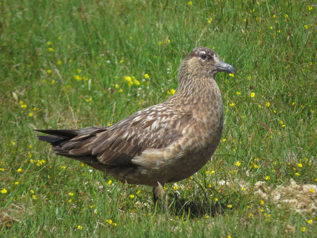
Once I got to the rounded top of Houlina Gruna I was up on the ridge and followed it north. I could barely see the Atlantic and the Loch of the Cliffs was now out of sight in its deep slot under the convex hillside. It was isolated and barren up here, and quite remote. There seemed to be a lot of Great Skua and they were watching me, occasionally swooping low to warn me. I sauntered along in the sun and suddenly saw a movement on the ground just before I stepped on it. It was a very young Skua chick. No wonder the Skuas were so aggressive; I was wandering through their nesting grounds.

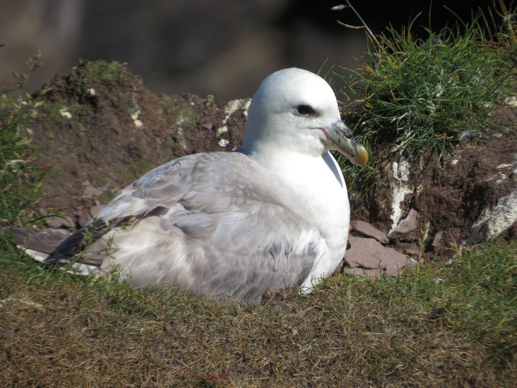
34. Even at a few days old the Great Skua chick has attitude and confidence. Its parents were dive bombing me intensely while I took the photo. It was a hiking day.
I lay down beside the chick to get a few photos. I held an arm aloft so the adults might clip that rather than my bald pate. The chick was quite helpless, perhaps a day ot two old. When I put my finger near the chick it opened its beak as if to receive food. Meanwhile the adults continued to swoop over me but never came closer that a metre. They were not as defensive as terns which would have made contact. As I continued north I came across 3 more Skua nests, which were little more than scrapes in the heather. In one a chick had recently hatched, while the other was just starting to emerge from the egg. Another just had 2 eggs and no chicks. It seemed very late for the chicks to be hatching.
There were other birds up here too trying to breed, like snipe and pipit which seemed quite foolhardy given the number of Skuas was about 2-300, and they would have a pipit chick as a snack. A bit further on I came across a small pond with a red throated diver. It was not breeding here, it was too small a pond and there was no islet. It was just here to preen itself and wash in fresh water. I watched it for 15 minutes before moving on north to Tonga headland where more Skuas had gathered.

35. A red diver at a small lochan on the Hermaness peninsula. The diver was just preening here and not breeding here. This was a hiking day.
I was now approaching the gannet colonies and got my first whiff of guano as it wafted up the cliffs. More and more feathers appeared on the moreland and the fringe of the plateau above the cliffs became verdant and grassy. The small delicate Shetland sheep grazed here on the close cropped, well fertilized pasture. As I approached the Neap the glistening white gannet colony came into view. There were thousands and thousands of birds breeding here on the steep slopes and ledges. The rock was not sedimentary with nice ledges, but sloping so the gannets had to build up a wedge shaped nest. I spent half an hour watching them circle round in a throg and occasionally landing to bicker with the neighbours before settling down. The throng did not seem as big as it did over me in the kayak, and I am sure it was a magnet for them.
From the Neap I walked on into the heartland of the spectacular scenery around Hermaness. The stacks here were covered in gannets and the air was full of them as they circled round. I could not see any young through my camera lens but it was quite confusing to see much on the steep rocky slopes. There were about 5-6 stacks altogether and they were perhaps more visible from here on the hillside above them, than the kayak. I walked on, almost to the end of the peninsula where the path went down to a grassy prow.

36. Looking over to the rocky islands of Muckle Flugga from Hermaness. Out Stack, the most northerly point of the British Isles, is just out of the picture to the right. This was a hiking day
As I neared the prow I noticed a few puffins flying around but it was only when I got to the end I could see the grassy slopes below were teeming with them. I came across Rob and his wife who were lying in a sunny hollow watching them. They were enchanted with the birds here and had spent all day for several days now at this very spot watching them. I asked them if they had seen a kayak pass by 2 days ago and they said “yes, I fact I have some photos of the kayak with a huge mass of gannets out there at Muckle Flugga” I explained it was me and he promised to send me the photos after he got home in 2 weeks.I chatted to Rob for half an hour smitten by his enthusiasm at watching the birds and his thoughts on their behavior.
I returned along the cliff top path past many more puffins burrows, with nervous puffins standing sentry outside the entrance. I did not see one with sandeels and nor had Rob so obviously the eggs had not hatched yet which again seemed very late. I retraced my step back past the gleaming stacks of giant teeth, sharp and glistening in gannet, and up to the Neap again. From here I went down the duckboard walk for a couple of kilometres to reach the parking place for the usual walk to Hermaness. It was located in the deep Burra Firth, a fjord like inlet, with a great sweeping sand beach at its head.

37. Many puffins nest in burrows along the turf fringes ontop of the cliffs at Hermaness. This was a hiking day
At the sandy beach, there was a kilometre wide bar which damned Loch of the Cliffs and separated that freshwater loch from the salty Burra Firth, otherwise I am sure the firth would have extended right up the loch. Hundreds, perhaps 500, Skua had gathered here to preen themselves in the freshwater at the north end of the loch.
From Burra Firth I walked the 4 km through a cultural landscape of scattered crofts to Harolds Wick. Here there was a replica Viking Longhouse and a Viking boat, both about 25 metres long. The boat sailed from Scandinavia a decade ago en route to North America ro replicate a voyage but only got as far a Shetland before the project ran out of steam. I now had another 4 km walk over the Keen of Hamar hillside where I heard snipe drumming and saw many curlew. I knew I was nearing Baltasound where I reach the infamous “Bobby Bus Shelter”; an ordinary bus shelter which Bobby had done up with table and chairs, a small library, a clock and even a television. I walked into Baltasound past the scruffy hotel, of which many locals were disappointed in it’s demise and I had been told to avoid. It was nice to get back to Willy’s B&B in the early evening and put my feet up. I was now ready to move on to Fetlar and the weather looked ripe tomorrow.

39. Near Haroldswick is a replica of the Gokstad ship. It was built in Sweden in 2000 and destined for North America to emulate Lief Erikson’s discovery of the continent some 500 years before Columbus. The ship made it to Unst and the project was abandoned. This was a hiking day.
Day 19. June 23. Baltasound to Houbie. 35 km. 7 hours. There was no hurry today as it was an improving forecast from the morning force 4 to the predicted winfstill evening. I signed the Winwick B&B visitor book, got lunch from the shop and eventually set off at 1100 and was gently blown down the sound by the westerly wind. Passing mussel farms I rounded the corner and came across two delightful white sandy beaches. Just after the first I saw only my second otter of the trip. I stopped paddling and it swam towards me and got with a few feet before it gently dived. II think it was oblivious to the fact I was a human and though I was marine bouy. I had the headcam on for the whole encounter.
The small southern island guarding the entrance to Baltasound haven was almost connected to the mainland by a white sand tombola. If the sea level was to fall perhaps just a metre I would wager that at low tide it would be dry. A bright finger of sand stretched out from both island and Unst towards each other, like the Creation of Adam painting by Miichaelangelo. A little south of the tombola I saw another otter, but this one saw me dived and the swan underwater to the shore and scurried up between the rocks.
The wind had dropped to a force 2 now and it was a pleasant paddle down very jagged rocks along the coast. Just above the rocks was pasture where sheep grazed. I passed two cleared or abandoned townships, Colvadale and Framgord, each with about 10 crumbling stone croft houses surrounded by grey stone dykes, which apportioned the grazings and potato fields. On a summer’s day 200 years ago these townships would have been full of laughter and the incense of peat smoke. Now they stood forlorn and forgotten. The descendants of the inhabitants now baristas in Auckland or graphic designers in Toronto unaware of their roots 10 generations ago. It was sad to reflect on those halcyon days but in reality life would have been hard and the Auckland barista will live twice as long as his crofting ancestor.
I hugged the coast on the way down until I got to Sand Wick bay. It is often a mistake to paddle from headland to headland as it is often only 10-20% longer to follow the coast. The foreshortened viewers the cockpit of a kayak make it look a much bigger detour to follow the coast than the map shows. It is an optical illusion as it is usually not much shorter and there is nothing to see. No otters, birds or seals venture far from land. My rewards for hugging the coast was a couple of Great Northern Divers between the jaws of Sand Wick – which I did cut across having said all that about detours.
After leaving the bright sands of Sand Wick behind me I paddled round Muness. I could see the ruined castle on the knoll in the middle of the peninsula surrounded by modern croft houses, standing white and proud against the verdant pastures. It had a very easy coastline today and i could explore and weave between the skerries as I went down. At the southern end of the peninsula I decided to paddle across the strait to Haaf Gruney island and have lunch. The swell was perhaps 30cm and there were no waves or tides so I could pretty much land at will anywhere.
As I approached the island hundred of geese which were grazing on the pastures here, along side sheep, took off in a tornado of flapping and honking. This frightened the sheep who all ran down the island, not realizing that the geese are always far too nervous. I saw a sheep fank and remains of a stone shed on the western edge of the island and guessed it would be a good place to land. I was a calm rocky inlet full of the large oarweed stalks which much have got ripped off in a winter storm, but had yet to rot. They cushioned my landing and I could get out and stretch.
After lunch I headed directly south to what looked like an interesting coast at Birrier Head. The cliffs here looked white as if they hosted an auk colony. It was an easy 3 km with the wind behind me. While there were no birds and the white was the recently exposed rocks after a landslide the coastline was teeming with grand architecture. There were an few impressive stacks, many caves and geos and even a long arch. I weaved through them in the virtually still sea following passages which always lead through to the next feature. There was just one cul-de-sac. This lasted for a good kilometre before I cut across Wick of Grunting bay to Hesta Ness a couple of km away.
Hesta Ness heralded the start of a magnificent piece of coastline. The rock here was conglomerate of small boulders cemented together by a igneous or metamorphic mortar. I was surprised it was hard-wearing enough to withstand erosion, and even form a headland. For the next two kilometres I followed a series of channels beneath stacks and wove between slots. At one stage I saw a tunnel through a stack, Inner Brough, and decided to go through it. There was a bird here at the entrance to the tunnel pecking the exposed seaweed and I could not work out what it was. It was small and delicate like a sandpiper but more elegant and rufus. Then I realized it was a red-necked Phalarope, one of Britain’s rarest birds, just 6 foot from the end of my kayak, and the head cam was filming.
Elated by this I then paddled on to the tip of Strandburgh Ness round the corner where there was another stack; Outer Brough. I could see from the map there was a iron age fort here and now in reality I could see why. It was a impregnable citadel of vertical rock rising out of the ocean on all sides. It was separated from Fetlar by a slot some 10-15 metres wide and 200 metres long. I paddled into the dark slot with the sides rising vertically on each side of me for 30 metres until it opened up again on the east side. I presume when the Brough was a fortress homestead there was a driftwood and woven grass bridge over the slot from Fetlar.

41. Off the northern tip og Strandburgh Ness on Fetlar a narrow channel some 200 metres long separates Fetlar Island from a stack called Outer Brough. There was once a monastic Norse settlement here on the stack and the adjacent Strandburgh Ness peninsula
The east side of Fetlar was perhaps 6 km. It could have taken me an hour, but it took over 2. It was a world class paddling trip in benign conditions. The first section to Head of Housta was probably the best. Here the rock reverted back to uniform grey rock from the conglomerate of the headland. Within this bay of grey rock were many arches, caves and stacks. Scambro Stacks at the southern end of the cliff ringed bay were a collection of 3-4 stacks with channels between most of them.
42. The east side of Fetlar is rich in coastal features with many stacks, caves and arches. It is possible to weave around the base of the Stacks of Scrambo between channels
As I paddled south I disturbed many groups of seals dozing on the rocks and skerries. Sometimes I was upon them so quickly there was no time for them to shuffle into the water and they just looked at me hoping I was not a predator, while I could smell their breath and see their bristly whiskers. There were no stacks here but there were plenty of small sharp skerries to weave amongst. High on the cliffs above were occasional fulmars and in the water, the solitary Black Gullimots, or Tiest, sheltered in the deep lagoon caused by the skerries. I saw a couple of tiest with brown wriggling butterfish in their beaks.

43. On the east side of Fetlar there are many skerries which are used by seals as pull outs between the tides. Most of thre seals are Grey Seals here.
I crossed Funzie Bay and headed to the south side where there was another fantastic collection of stacks. After one dead end on what I thought was an island, but was just not, I managed to tread a way through. Shags dived into the water from ledges above as I paddled by, while fulmars looked on from their nests above. I saw the odd puffin here but could not see any colonies, but the tops of these stacks looked perfect habitats for them. The coastline continued to be spectacular all the way down to The Snap, the southern headland of east Fetlar. Across the ocean I could see the shallow grey silhouettes of the Out Skerries and Whalsey Island, both about 15 km away across the open North Sea.
There was a slight headwind as I pulled up the south coast towards the village of Houbie in the large Wick of Tresta bay. The coast line here was still impressive with quite a few caves and bays, one with white stacks, They were specially plentiful around the Wick of Airth bay which seemed to have a huge arch and caves on each side. However I was now wanting to reach Houbie so did not go right in to investigate. After one more small headland, Airth Ness, I saw the pier. There was a smaller slipway beside it which I landed at, put the trolley together and heaved everything up onto the grassy fringe between beach and road.
I had made arrangements, with Lucy who ran the shop with her sister, to camp in her field near the village hall. I phoned here as agreed and she came to meet me and showed me where to camp. The village hall had toilets and water so I was made. She also ran the islands B&B together with her sister but unfortunately it was fully booked as the forecast tomorrow was not good. However she said I could use the residents lounge in the B&B to relax and write in. It was beside the shop and cafe so I would invariably take her up on her offer. After Lucy had gone I pitched my tent. A neighbour, Kenny, came over and chatted. He owned the Old Manse beside the village hall. He was from Edinburgh so we hit it off and he quickly filled me in oon the politics of the island which had about 60 residents. He ran the history museum by the pier so I knew I would see him again.
Day 20. June 24. Houbie weather day. 0 km. 0 hours. When I woke in the morning after a good nights sleep there was a warm glow in the yellow/red tent. It was a very strong Helsport Patagonia and was rock solid with its double set of poles so I felt cosy in my sleeping bag. There was the sound of drizzle on the flysheet but I ignored it. When I eventually went out at 1000 it was a foul day with a force 5 wind and sheets of rain. After a few minutes I was drenched and fled back inside.
There was nothing else to do today than flee to the shop/cafe with the adjacent B&B’s residents lounge and write. As the day progessed the weather got worse with the wind increasing to a force 6 and the rain becoming very heavy. I was confident my tent was OK, out of sight by the hall, with what the weather was throwing at it. I had two stints in the cafe which was largely occupied with wildlife tours. They seem to be very common in Shetland and are usually made up of very well spoken people, but I did notice a lot of one-up-manship among the group members about far flung places they had travelled to with celebrity naturalists. In the B&B the clients were all local Shetlanders who were shot blasting the ferry pier. In a previous incarnation I was a blaster/sprayer so had a great affinity with them. They had me down as a twitcher with my accent, so were surprised and enthusiastic when I showed them my scars from the hogger (blast hose).
By early evening I had finished writing and returned across the sodden landscape to my tent. The rain had now ceased but the air was damp and the north wind was cold. It will be an early night. Tomorrow promises to be a dry day but it will be too windy to paddle the 16km to the Out Skerries.
Day 21. June 25. Houbie weather day. 15 km. 4.5 hours. There was still the occasional shower in the morning so I stayed in bed until 0900. Kenny had invited me over for morning coffee so I went there at 1000. He had moved up from Edinburgh 40 years to Fetlar where his wife was from. He worked for the council while his wife ran a guesthouse at the East Manse. However some 30 years ago she had fall down a rocky grass bank and was lucky to survive but had to give up taking guests. Kenny pretty much ran the croft on his own managing his 120 sheep. The conversation moved on to the Bellis family. Everyone on the island had an opinion on them.
I could not complain as Lucy had allowed me to camp in her field and her sister, Juliet, allowed me to sit in the cafe and resident’s lounge of the B&B during yesterdays downpour. However it seemed few of the locals were enamoured with them. Some 15 years ago they ran business worth £400 million. But all that went belly up in 2007 leaving a lot of investors out of pocket. Iain Bellis was struck off as as QC and his wife Juliet as a solictor. From what I could garner on the internet they managed to squirrel enough money away despite the liquidation of their firms to leave Sussex and head up to Fetlar in 2016 to start a new life. According to all the locals they had not changed their spots and were now using their fortune to slowly acquire the island, piece by piece as they came up for sale, out bidding the locals by paying over the odds from their bulging coffers.
Before I went for my walk I went into the Heritge Centre. Fetlar had been a well populated island with well over 1000 inhabitants 200 years ago. The Sir Arthur Nicholson started to aquire it and eventually had enough to be the dominant landlord. He then proceeded to clear the island of its tenants, whom he considered troublesome and not profitable. Starting with Gruting he cleared some 10 townships along the north coast of Fetlar. He made his tenants destitute by removing and destroying the roofs of their croff houses. They had to make their own way to Mainland Scotland or pay for passage on a ship to New Zealand, Australia or Canada. He became a hated figure
Another historical figure of Fetlar was Willian Watson Cheyne, who grew up at the West Manse. Already middle class he went to Edinburgh University to study medcine and became Lister’s right hand man in Antiseptic research. He went on to become chairman of the Royal College of Surgeons and a weathly man. He adored Fetlar and retired there building beautiful and modest Leagarth House in Houbie. The Cheyne family still own the house 100 years later and a fair chunk of the island. He is a greatly admired figure.
After lunch in the cafe, where I read all about Judith’s business shenanigans on the internet as she served me, I went for a long walk. Intially I went down to Tresta Beach. It was a vast crescent of golden sand and near the West Manse, Church and Graveyard. Inland from the beach was a grassy meadow of machair. This meadow formed a dam containing Papil water, a freshwater loch. I looked for birds here but only saw 100 skua who were preening themselves in the freshwater. I did flush a snipe who was hiding in the long grass and it flew off darting and weaving very acrobatiically for a bird with such a bulbous head and cumbersome beak. I continued to the south of the grassy links meadow between salty beach and freshwater loch and then climbed up onto Lamb Hoga, the great peninsuula of SW Fetlar. There was an old track here which had been used for centuries to bring peat back from the cuttings on Lamb Hoga to the village. The track climbed for 2 km until it petered out in the peat beds. There were hundreds of Skua gathering here and it must have been a major breeding site.
I wanted to walk round the perimeter of the peninsula so left the track as it faded and slogged across heather over the highest point, Gillis Field, and then down steeper grassy slopes which lead to the top of the coastal cliffs, which were about 100 metres high in places. I could look down the slopes to the calm sea below and see some small stacks and scattered colonies of fulmars tucked away in lofty nests, usually in natural pockets and often surrounded by prolific growths of rose root. Even in the near gale these nests looked very sheltered. After I passed Big Holm the peninsula became a verdant grassy plateau suurrounded by 50 metre cliffs. It was prime pasture for the hardy semi feral sheep which grazed here. Unusually the sheep were very nervous of me and ran off at 200 metres distance. I wondered along this lost world of velvet close cropped grass for a kilometre to the very tip. Here unbeknown to me I had driven some 10 geese and 20 goslings to the very tip. Some of the geese leaped off the cliffs but the goslings could not fly and darted about looking for an escape. I backed off before the Skuas discovered them and picked a couple of the defenceless youngsters off.

44. Lamb Hoga is a peninsula on the south side of Feltar. The are Phalrope, Skua, Geese, Fulmars and Auks breeding on it. This was a hiking day.
The south tip of the peninsula was a wild place. the sheep here seemed to have their lambs very late and a few looked newly born. They all fled as I approached. I got to a stone dyke and came across a sheep which had just given birth, but the lamb seemed stillborn and the sheep was lying beside it. It seemed a ram had got to these ewes around end end of January which must have been unintentional. Skuas were already starting to gather.
From the map I could see there was a small lochan nearby. I went to investigate and saw it was fringed with small rushes and had a couple of small islands on it. Perfect Red Throated Diver habitat; but there were none. Instead I saw a Red Necked Phalarope in the rushes darting about, then another, and another 4. There were 3 breeding pairs here in all. They were not too perturbed by me and I sat for almost an hour watching them. I got some photos with my compact but cursed the fact I had left me zoom camera in the tent. The 6 Phalaropes where zigzagging through the rushes searching for insects and larvae. Occasionally they would head off to an islet and go into a a thicket of marsh marigold which is where I assumed the nests were. It was quite a privilege to watch these busy, delicate birds, sometimes just 2 metres away, go about their business. There were also a couple of pairs of Dunlin foraging around the edge of the lochan, their chests an unnatural black as if they had bathed in tar.

45. A cluster of Red Necked Phalarope on a lochan on Lamb Hoga. The Phalarope breed all over Fetlar. This was a hiking day.
I continued round the edge of the peninsuula poast a couple of small arches and then headed across north across the spoungy heather and moss to the faint track I left 3 hours ago. The route took me through a large skua nesting site and they dived bombed me frequently as I approached their nests. I only saw one and it had 2 eggs in it. Like typical bullies the Skuas were also cowards and I never felt uncomfortable as I knew they would pull of of their dive a good few metres from me. I crossed a few old peat cutting areas and then found the track. I followed it in the breezy afternoon sun back to Tresta Beach and then on to the cafe which was closed.
I heard a motorbike approach and knew it would be Pete, the ferry skipper. I had met him previously in Shetland and we had a mutual friend. He invited me back to his for a cuppa which turned into dinner. Pete was a high performing outdoors man and a champion kayak surfer. He had a living room wall display of all his greenland paddles, all of which he had made including the hollow carbon fibre ones, which is tremendously skillful. His girlfriend Julie was also an acomplished climber and outdoors women. I would not have expected a house on Fetlar to be so full of ice tools, climbing racks and ropes. Pete and Julie were kindred spirits and I felt very much at home chatting to them. The confirmed what I had already garnered from other locals and the internet that the newly arrived Bellis family were not popular and not straightforward. It was after 2200 when I finally left and walked back to my tent by the village hall. A quick look at the tide charts and weather forecast showed I had to be quite sharp tomorrow, so I set the alarm for 0500.
Day 22. June 26. Houbie to Out Skerries. 24 km. 4.5 hours. I managed to pack up early and saw Kenny as he walked his dog. The wind was from the NW and was a force 3 or 4. The sea looked calm but one should always be aware of a offshore breeze as one cannot see or judge the waves. I knew far out to sea, beyond my vision there would be a big NE swell once I left the lee of Fetlar. I could see my destination, Out Skerries, distant and grey-blue on the horizon, with no features visible other than their shallow silhouette. I hoped their would be a small current in my favour as it would soon be flooding southwards. I eventually left at 0800 and paddled over to Head of Lambhoga on the peninsular where I had been yesterday, and where I trapped the goslings on the cliff edge. It was a gentle 3 km paddle.
After that I was into the raw North Sea for the 16 km open crossing. I set my bearing on the lighthouse which I could just see at the easty end of the Out Skerries. The wind was westerly now and I had lost its advantage so I factored in a vector for this and another for the south going tide I eventually hoped to meet. The crossing took about 3 hours altogether and there was very little influence from the force 3-4 starbord side west wind and even less from the tide. Byy the time I got a quarter of the way across the full NE swell generated over the last couple of days started to charge of the North Sea. It was a lazy undulating swell with a 10 second period and occasional peaks which might have been 3 metres. It never really got that steep and I was relaxed paddling across it.
The crossing took longer that I expected and it was all of two hours before I overcame the curvature of the earth enough to see the surf crashing on the northern shoreline of the Out Skerries islands. When I could see it clearly I knew I was about 5 km away. By this time the tedium of the crossing had taxed my patience as I imperceptably saw my destination darken and spread out across more of the horizon. It all happened at a snails pace but I was thankful for reasonable conditions. A few kilometres out I could make out the the two inlets to the safe harbour beyond, the North Mouth and the North East Mouth, seperated from each other by the island of Bruray. To the east of them was a large skerry with a lighthouse. I wanted to go on the outside of the lighthouse so veered east.
47. Out Skerries are a cluster of 3 larger Islands separated by channals and a lagoon. To the east of the Out Skerries is a rocky islet with a lighthouse
It was only when I was about a km from the Out Skerries did the tidal current appear. It woyuld be parting with a stream going each side of the island cluster. I was very wary of it after the Muckle Flugga fright and especially with this 3 metre swell so I scanned the distance for anything untoward. My pace picked up and I was soon doing 10 km p h as I sped towards the lighthouse. There was alot of turbulence nearer land, especially at Flat Lamba Stack, but a km out there was no clapotis or white water. The tide swept me to the lighthouse quite quickly and I was quite close to land when I passed it. The swell was steeper but it was not breaking.
However, once I passed the estern tip there must have been a powerful eddy current flowing north from Horn Skerry and it was slamming into the residual swell which had made it through the primary tidal flow and it was very choppy for a few hundred metre with many small white crests. I had to paddle hard here to overcome the flow in the eddy. I passed a couple more smaller skerries with the tide flowing out of the gaps between them like a river as it flooded south until I reached the relative calm on the south side of Grunay Island in the lee of the swell and much of the wind.
The Out Skerries are made out of 3 principle islands, Housay, Bruray and Grunay. Bewteen the islands are the channels which lead into a sheltered lagoon flanked by all the three islands. It is a superb natural harbour. I entered this lagoon by the South Mouth. I had to ferry glide across the tidal river which was flowing into the sheltered lagoon by the 2 northern entrances and exiting out of the south against me, but it was a calm, waveless stream. After some stronger paddling I had gained the calm of the lagoon and it was another world. A few rafts of eider duck and ducklings swam along the gentle edges and in the bays off the lagoon the water was mirror calm and crystal clear. It was a sanctuary from the turbulent sea just beyond the protective embrace of the islands.
Two of the islands were inhabited and they were connected by a bridge. On Bruray I could see the pier and school. It looked slightly more the working side while Housay looked slightly more residential. There was no one about so I paddled up to the bridge and under it into another bay where there was an abandoned fish farm and a small marina. I met Ethan at the marina, his hand covered in black oil as he tinkered with an engine, and asked him about accomodation. He suggested his Grandmother and pointed out a large house beyond the marina. I landed and went up to it and was greeted by Alice. Immeadiately I could see she was a strong and warm character. She invited me in for lunch. At the table were Alice’s mother and mother-in-law, both of whom were born here 85 years ago, and soon we wewre joined by Ethan and Alice’s husband. They were a very warm and jolly but I struggled with their strong Shetland accent.
After lunch Alice explained that 2 of her children and a few grandchildren were coming on the boat for the weekend and the house would be chaotic. She suggested I would be better off in a self catering cottage she had, called Hillside. It was on the other island. We went over to it and it was perfect. A washing machine, shower, kitchen, comfortable lounge and well equipped kitchen. There was a large glass porch with a dining table overlooking the lagoon where I could write. It was near the Bruray shop (which appently is better than the Housay shop). I had really landed on my feet here after cmping in the field on Fetlar. Alice and her husband even lent me a car so I could drive the 1 km of road on the two islands, 500 metres on each. They did they utmost to make me feel at home and comfortable. I am going to enjoy my time on the exceptionally friendly Out Skerries.
I washed clothes, showered, enjoyed the peace of the comfortable house and wrote for the rest of the afternoon. About 5 years ago Out Skerries had a population of 60, mostly employed in fishing from the superb harbour or on the fish farm. It even had a small cinema. However the fish farm closed and is lying abandoned and with its demise many men who worked on it left the island to find jobs on the mainland. They took their wives and kids and suddenly the school had no pupils and had to close and the po[pulation dropped to 24. It also had an incomer landlord who bought the unpopulated Grunay a decade ago and later bought the other two islands. I have not found out yet if he is liked or not.
Day 23. June 27. Out Skerries Weather Day. 10 km. 3.5 hours. I woke in the comfortable bed, delighted I had a windy weather rest day. It was dry forecast, but the winds were due to be force 5-6. It gave me a great opportunity to continue my current pattern of a paddling to a new destination and then a day exploring it on foot. Out Skerries with its two smaller connected islands will be a joy to walk round. I lounged around the house, luxuriating in the space and comfort and then set off after lunch.
I walked round the perimeter of Bruray first, starting at the main pier, where the ferry came in. There was a smaller scallop dredger moored up. It is a frowned upon form of fishing as the metal cages literally plough up the sea bed scooping up everything and destroying the sea floor. The sea bed takes a few years to recover however the sandy bottom is usually repopulated by king scallops quite quickly so is regularly trawled allowing the sea bed no time to recover its ecosystem. There was a shipping container size ferry terminal which was open and had a microwave and kettle. It would have done nicely in an emergency.
I then walked up the NE Mouth of the lagoon to a bay with a stony beach. Rabbits were everywhere and scurried for their burrow complexes as I approached. There was a great view of the lighthouse on the skerry just to the east. I was shocked just how benigh the sea was now. The 3 metre swell of yesterday had completely vanished and the sea was gentle. The turmultous seas yesterday around Flat Lamb Stack and it’s neighbouring stack were almost mirror calm now. There were lots of shorebirds here especially the ringed plover and oyster catchers. The plovers must have had young in hiding in the grassy and sea pink meadows as many of them were feigning a broken wing to lure me away. I carried on round the north coast to the North Mouth, a narrowing channel between the two main islands which funnelled down to the connecting bridge. Just before the bridge I noticed a course of half glazed pipes traversing the hillside I followed their course down to a dam and realized they were to collect rain water for the islands water supply.
At the bridge I crossed to Housay, the biggest of the Out Skerry islands. I walked round it clockwise going along the south coast first. It was a rugged coastline with 15-20 metre cliffs, full of geos, small stacks and jagged skerries. I did not see many seals here in the bays as I would have expected. The tops of the cliffs were rocky as if the sea spray from winter storms washed it frequently eroding any soil which might gather. Where the soil clung on it was covered by carpets of sea pink in full blossom. Terns gathered in groups on the rocky crest of the cliffs but they were not breeding here and flew down the coast for 100 metres each time I approached them.
As I approached the end of the island I came across a deep gash which cut across the whole peninsula and blocked my path. There were ropes down into the bottom of the slot and back up the other side but they looked a bit suspect and not worth the risk to reach the end. In a storm I am sure the sea would have swept through this deep gash from one side to another. On the far side of the gash fulmars snuggled into their nests some 10 metres away on the other side
I turned and walked back along the NW coast, passing the cable where the electricity came ashore at Cobbi Ness and then reached a deep bay, called West Voe. The entrance was just 20-30 metres wide but it opened up into a sheltered inlet 300 metres wide and a kilometre long. There was an abandoned fish farm here also with 6 cages left in situ. Parts of it had washed ashore as the rest of it would in the next decade. The barges supporting the feeding containers and another with the washing equipment were rusting hulks, just fit for scarp if that. I have heard it said that fishing gear accounts for 50% of marine pollution. Not here on the Out Skerries where I think it was closer to 99% with fish farming cages, tubes and bouys accounting for nearly all of it. It was quite shocking to see the extent of it and Shetland Council have to really take some responsibility to remove this one and the one by the bridge. The Out Skerries community cannot remove it alone as it seems to be on its knees financially.
After the abandoned rusting debris of the fish farm I met the road and followed it up the short hill to the saddle where the houses started. There were perhaps 20 in a loose cluster on this island, including Alice’s where I was yesterday. I crossed the bridge and returned to Bruray Island. I dropped in to the Rocklea Guesthouse, but it seemed to be dormant. Then the grumpy English incomer who owned the place told me it was closed, which is not what his flowery and embellished website said.
I really liked the Out Skerries, it reminded me of a Norwegian “Fiskevaer”. Both thrived in in the 1800’s as a place where folk moved to to fish more distant, deeper waters, and then they boomed in the herring fishing era. However with the invention of the engine it was not so necessary to live on the edge of the ocean, and with the demise of the herring fisheries these places were slowly abandoned. As with the Norwegian “fiskevaer” I think the writing is on the wall for the Out Skerries unless it can attract another marine industry. Despite the similarities the Norwegians would never have just left the two abandoned fish farms in situ to rust and wash ashore in storms to degenerate and would have kept the place clean and tidy.
Day 24. June 28. Out Skerries to Symbister on Whalsay. 21 km. 4.5 hours. I cleaned up Hillside house as much as possible and went to the post office which was from a bygone era to get some cash out. The tide was out when I dumped my stuff beside the kayak and went up to Alice’s. Her mother and mother-in-law were there and the three of them went on a mission to find me somewhere to stay in Symbister in Whalsay. The mother-in-law who lived on Whalsay eventually managed to get hold of a friend who rented out a small chalet and it was free that evening. I was quite content to camp but having a shower and table to write at is always a joy. I had a coffee with them while the squad of great-grandchildren ran amok outside. I found out a bit more about the owner of the 3 skerries islands. He was Richard Briggs and ran a company called Skydock. I looked him up later. He seemed to be an arms dealer and possibly trained insurgents in Lancashire, almost with the approval and certainly with a blind eye of the MOD. What is it about small vulnerable Shetland islands which attracts such suspect characters. Perhaps Richard will use Out Skerries to train insurgents and militia when enough of the population leave.
I launched at 1100 and paddled out with the current under the bridge, across the lagoon and out of the south entrance. It was much windier in the North Sea than predicted and I thought it was almost a force 5 ;-and it was directly into my face. I hugged the coast I had walked down yesterday to try and get some lee from the wind. It was much quicker paddling than walking and in no time I was at the chasm which separated the most western kilometre of Housay from the rest of it. To my south were the green Benelip islands, which although small, had great pastures. As I left the shelter of the Housay the wind was a good 4 again. It was certainly going to slow me down today. Also at the west tip of Housay I paddled into the south going tide and the sea became quite choppy as this tide hit the small east going waves. The tide carried me a little to the south before the strongest stream nearest Housay started to fade away.
It was only some 8km to Skaw point on the very east of Whalsay. However it took over two hours to paddle it. The oncoming waves often sprayed into my face as the kayak slapped into them. Skaw Point did not seem to be getting any closer and looking at my GPS was disheartening as I only seemed to be doing about 4 km p h. On and on I plodded into the oncoming waves with very little changing. Looking at my track I was herding too far to the south and this must have been due to the flooding tide heading south and my current trajectory would have taken me well to the south of Skaw Point. So I pointed the boat to the NW and plodded on. My speed dropped to 3.5 km p h. I was bursting for the toilet but dare not take my hands of the paddle in this choppy sea so paddled furiously to speed my arrival until the urge had passed. Eventually after a two hour crossing I was finally approaching land. My original plan was to go down the south side of Whalsay, but after looking at the small white surf down the coast and the SW direction of the wind I opted for the easier north coast.
As I approached Whalsey I saw a ride-on lawn mower cutting grass and then a golf green and pin flags. I had not expected that but I had heard Whalsay was a well heeled island with many fishing millionaires. It was certainly a far cry from Out Skerries. As I crossed the bay on the north of the golf course towards Inner Holm of Skaw the wind stopped and the sun came out. It was quite a relief. There was a river of current flooding south against me and I had to paddle hard to burst through the narrows formed by Inner Holm to gain the north coast of Whalsay. However to my dismay the westerly force 4 wind had returned and it looked like it would be with me for the rest of the day. I think the south side would have been worse though. I plugged on into the wind hoping for some tidal lift as the current would go north along Whalsay before going south into Linga Sound but there was nothing discernable. I eventually gained the Chalister Ness headland and the next heat land Kirk Ness appeared in the distance. It was a grassy island really connected to Whalsay by a narrow isthmus or tombola of gravel. Sitiing in the middle of the flat green island was the solid stone church. It took nearly an hour at 3 km p h to reach it. One thing I did notice about Whalsay was how well kept it was. All the fields round the houses were rich pasture and the land here was productive. I was also quite surprised how large many of the houses were. There were no abandoned derelict ones and the old ones were still maintained, even if a bigger, more modern one was built beside it.
At last I picked up a kilometre of tide as I entered Linga Sound. I was almost in Symbister now. The Out Skerries ferry went past and I could see the skipper waving from the bridge. I paddled past a dormant fish farm and got to North Voe. I could have gone in here as it was closer to the Jean Mary’s Chalet but I needed the shop and was interested to see Symbister. Wearily I paddled through the breakwater just in front of the car ferry to enter a sheltered port. I heard there were some very large trawlers based here but they must have been out at sea. The port was full of wharfs and marinas and I paddled into the inner sanctum and found a nice concrete ramp neat the sailing dinghy club. I puled up here and extracted myself from the kayak. I must have trapped a nerve in my front left hip and I was stuck standing beside the kayak for nearly 10 minutes until the painful spasm receded. I then pulled the boat up and was changing when the skipper of the Out skerries ferry, which was moored here for the night, came and chatted to me.
I could see Whalsay was affluent. Even the dozen sailing dinghies looked very technical and they were well anchored down with new cargo straps to metal bolts. The marina was full of leisure craft, some quite fancy. I took just what I needed and walked round to the Aladins cave of a shop. It was huge with many different departments and sold everything from anchor chain to brie cheese. I got enough food for the next 24 hours and then struggled up the hill to an old church. The gardens here were also well kept, with lots of shelter trees to protect them. I got to the chalet with Jean Mary waiting for me. She showed me in. I was a far cry from Hillside on Out Skerries but had everything I needed. I was only 1730 but I was surprisingly tired but managed to cook, shower and write. The headwind had taken its toll.
Day 25. June 29. Symbister to Noss. 33 km. 6 hours. it was easy to get up early, but it still seemed to take about 3 hours from getting out of bed to launch, but today was even longer as I had a breakfast to cook. I eventually set off at 1030 on a calm morning with a slight northerly wind. I filled up the water bottles from the ferry terminal and chatted to a couple of people at the sailing dinghy club who were working on their skiffs, which were all a local design. Whalsay had a population of 1100 but it seemed more as there was a lot of activity in the village and in the harbour.
After leaving the breakwaters I realised I would have the gentle breeze and the tide with me for most of the morning. Without much effort I was doing over 8 km p h. It was a far cry from yesterday and I sped down the remaining coast of Whalsay and then crossed over a large bay, Dury Voe, to Neap on the North Nesting headland. Before I knew it I was approaching the two sandy beaches at Wick of Neap. The map showed there was probably an island here but I could not see it. I trusted the map anyway and at the last minute a gap opened up between the Neap headland and Hog Island. Waves which had built up in the fetch across the mouth of Dury Voe vanished and I picked up speed again in the ripples. The problem with a following sea is my chunky barge of a kayak tends to wallow in the waves, surfing a bit and then sliding down the back of the wave as it passes underneath so I don’t get a constant speed unless I paddle furiously and keep abreast of the waves, but that is exhausting after a few minutes.
I repeated a similar crossing across South Nesting Bay to the Eswick peninsula 4-5 kilometres away and got there in just over half an hour. It was the perfect wind direction and strength for me. There were a couple of small stacks here which I could go inside as I paddled down the peninsula until the headland ended. I now had to make the longer 9 km open crossing to the northern tip of Bressay Island. It was a joy to paddle in these perfect conditions and I sped south passing Hoo stack. I saw a couple of porpoise here, their small fins breaking the water in an arch before they dived again. These were the only cretenans I had seen all trip so far. There were more and more sea birds appearing as I crossed the bay; both gannets and the auk type birds. It took a good hour before I was approaching Score Headland.
There were two possible islands here according to the map and if I could go inside them it would save a bit of doubling back. They were called Inner Score and Outer Score respectively. I hedged my bets and tried to go between the two but the channel which was marked on the map was a deep slot and it was blocked so I had to paddle round Outer Score. At the end of it about 100 geese took to the water. I must have chased them up to the headland. I looked back on land and there must have been at least 100 goslings looking lost and frightened, not knowing whether to follow their parents or flee from me. Once I rounded it a beautiful beach appeared on the south side of Inner Score. I needed a break so I paddled towards it. As I approached the beach in the sheltered bay a couple of Great Northern Divers flew off, their wings surprisingly far back on their fuselage, like Concorde. As I landed I noticed a gap between Bressay Island and Inner Score which a kayak could have got through, certainly above mean tide. It would have saved me 20 minutes had I gone for this channel rather than the other. It was a peaceful serene beach, windstill and with no surf, Even the sun tried to break through. I had lunch and lingered on it.
After lunch I paddled down the craggy coast with cliffs dotted with fulmar nests until I got to a deep bay and then cut over its mouth to the headland, Loder Head, on the other side. The Isle of Noss now filled the horizon. It sloped up in an even grassy slope from west to culminate in the 180 metre cliffs of the east. It had the profile of a nose and I am sure the name would have come from the Norse for nose. As I paddled across the sound to Noss I passed just half a km where I eventually intended to camp in a bay on the south of Noss.
49. The east coast of the Island of Noss risises up to the 180 metre high cliffs of the Noup. It is home to a huge gannet colony.
The sea was a bit rough paddling along the north coast of Noss due to the clapotis caused by the rebounding waves from the small vertical cliffs. However it was nothing to that of Eshaness or Papa Stour. More and more seabirds appeared and I heard the honk of gannets frequently now as they tried to evade and warn the attacking skuas, often to no avail. After a couple of km the coast became more jagged as I reached the NE corner and turned south. Suddenly it became very dramatic very quickly but the sea was calm and gentle so I could explore.

50. Thousands of Gulklimots breed on the sandstone ledges of Noss below the gannet colonies. They lay conical eggsa on the shelves so they dont roll off. If Shuas attack they all defend with a mass of spiky beaks presended like lances
The cliffs got bigger and bigger with each buttress I passed, first 40 metres, then 80, then 120 and 150.metres. between each was a quiet pool full of auk type birds, mostly Gullimots, with many being of the bridal variety. The cliffs were composed of striations of sedimentary rock and they were eroded into shelves. The auks filled some of the lower shelves with perhaps 1000 to a 50 metre long ledge. This offers them protection against skuas as an attacking skua will meet with a defence of spikes as all the bills point towards it. The auks will lay their conical eggs on the shelves so they do not roll off. Surrounding ther Auks were 1000’s of gannets, some on ledges, some in pockets and some on the open face where they had built a nest. Despite all the birds on nests or ledges I could not see any chicks. Gannets swirled in a throng above me and skuas picked out individuals in the throng and attacked it. The were usually only 2-3 skuas involved in an attack and often the gannets managed to evade them. It was not like Hermaness where 20 skuas forced a gannet into the water and threatened to drown it unless it disgorged its crop.
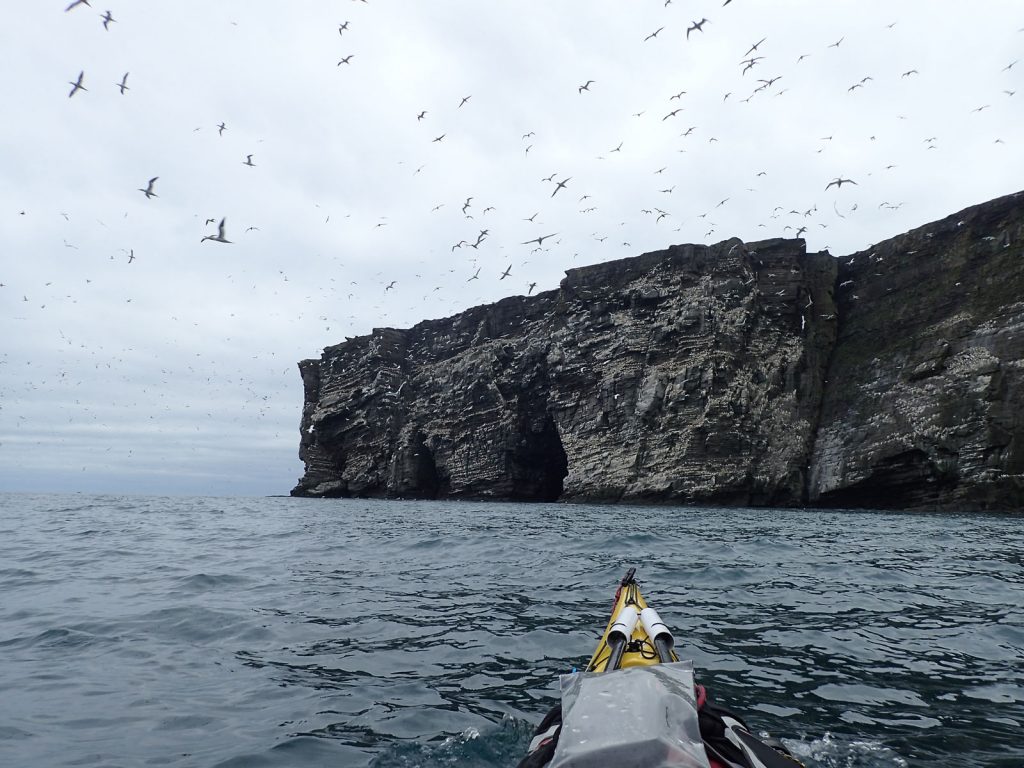
51. The main gannet colony of Noss contains many thousands of birds whjo nesy on the cliffs above the caves. They travel far each day for food but are attacked by skuas on their return and forced to disgorge they catch.
While the sea birds here were a huge spectacle the landscape almost outshone them. The cliffs culminated in a 180 metre prow which I am sure was slightly overhanging. It soared into the sky beside me and I almost got vertigo looking up it. There was a U shaped cave with two entrances which I went through and many other caves, To the south of this high coast was a vast vertical stack and it was just possible to paddle the kayak up the narrow deep slot which separated it from Noss. At low tide I don’t think it would be possible. In the caverns on each side of this dark slot shags were nesting and they honked and hissed as I went past. They were perched in nests of seaweed stalk and nylon rope fragments. This stack marked the end of this magnificent east side of Noss and I felt privileged to have seen it so close in such calm conditions,

52. On the SE corner of the Isle of Noss is a great stack seperated from the Isle by a narrowe channel up which it was possioble to paddle at all but low tide.
There were a few more seabirds on the south coast but the cliffs diminished quite quickly. There was a skua pecking the chest cavity of a dead gannet floating on the water. I don’t think the skua had killed the gannet, although they are capable of drowning them. Perhaps the gannet was vulnerable because of a broken wing or other injury. Two kilometres up the south coast of Noss was a deep bay with a sandy beach and the visitor centre for day trippers arriving by boat. The bay had many rafts of eider duck and young which moved to the sides as I paddled on to the golden sand. Above the beach was a grassy meadow teeming with rabbits. I found a nice place to camp here and had the tent up before the wardens came to greet me. I was ready to stand my pitch but they were very welcoming and said there would be no punters on the island tomorrow. As I retreated into the tent to write and cook I noticed the rabbits come out of their burrows in the early evening. There were literally hundreds of them and the meadow was swarming with them as they ate and frolicked. This is what it must have been like before miximatosis struck.
Day 26. June 30. Noss to Mousa. 20 km. 3.5 hours. I could hear the wind rustling the tent and when I put my head out I could see the red flag put out by the wardens to show the island was “closed” was taut. The south bay looked fine, but to the north there were plenty of white horses in the force 5 northerly. It was not what I wanted but it was sunny. Rabbits continued to swarm over the ground by my campsite. There must have been hundreds in this complex of warrens.
Before I left Noss I wanted to walk round the perimeter and knew that would take a few hours. There was also a small visitor centre where I went first to glean some knowledge about the place. The information boards were aimed at children but there were some good facts there. I started the circuit at 1000 and went anti-clockwise along the pastures of the south coast. They were being grazed by the delicate Shetland sheep, most with a plump lamb. There were many wheatear here, and oystercatchers were chasing each other. In the centre of the island was a sensitive area of ground nesting birds. Tern and Arctic Skua apparently, which seemed incongruous as the two are mortal enemies. It did not take long to reach the SE tip along the undulating path.

53. The great Syack on the SE corner of Noss as seen from the land. The watery channel is in the chasm. The surface of the stack was a breeding ground for gulls.
At the SE corner I reached the great stack. It’s surface was a grassy plateau at the same level as adjacent pasture on Noss. As there were no sheep here the vegetation was higher and I could see it was a breeding colony for Black Backed Gulls with at least 50 looking alert on it. There was a deep gash separating it from Noss, through which I had paddled yesterday. I could see now the channel I went through was dry.

54. The Noup of Noss from the cliffs beside it. The Noup rises some 180 metres out of the North Sea. There are about 25,000 gannets nesting in this bouyant colony. A hiking morning
From the stack the path climbed up to The Noup, a great prow 180 metres high. Occasionally the path afforded a view down the vast cliffs and I could see thousands of gannets. I watched some and saw there were indeed chicks. I photographed one couple feeding their fluffy grek chick for 20 minutes. The returning gannet was disgorging fish into the mouth of the chick, and it seemed its partner also. I looked down to where I paddled yesterday and it was a different sea down there today with near 3 metre swells crashing onto the rocks. The gannets dominated the cliffs here, but I also saw a few puffins and many fulmar. There were off course plenty of Great Skua also and I saw one Arctic Skua fly off into the swirling throng of gannets.

55. A pair of gannets feeding their chick. The gannets fish far at sea and when the return they have to run a gauntlet of waiting Great Skuas who force them to disgorge food intented for the chicks.
After the Noup the east coast cliffs now ramped down for a good kilometre until they were just 20 metres. On the cliffs here the Auks dominated, with a few deep ledges with hundreds on. I came across a small loch and went to see if Phalarope were there but it was a Great Skuas preening and rinsing pond so nothing else was there.

56. The Noup on Noss from the cliffs to the south near the Great Stack. There is a large cave at the base of these cliffs.
The north coast was pretty much devoid of birdlife except for nesting waders and oyster catchers. In the middle of the island I could see hundreds of Great Skua nesting in the marshy interior of the island and a few flew low over me to investigate. I returned to my pile of luggage in the midst of the rabbit warrens and carried it down to the sea in the sun. By now the wind had dropped to a force 4 but in the lee of the sunny south facing bay it seemed calm. The walk round the island was about 8km and took 3 hours, but it was thoroughly worthwhile.
57. A fulmar nesting on the turf just at the top of the cliffs. They and their helpless chicks would be vulnerable to Skua predation were it not for the oily vomit they discharge which matts predators feathers or fur.
58. A Great Skua. A agile and fearless predatory bird which survives by plundering gannets and eating the eggs and chicks of any bird.
I did not launch until 1400 and quickly paddled out of the bay and into the Noss Sound with the wind behind me, and a small south going tide. I paddled over to the impressive east coast of Bressay. About a third of the way down was a bay called Grut Wick. In 1995 I worked offshore with a group of 19 men for 3 weeks. We had a helicopter for the work to ferry us backwards and forwards to Teeside each day. The helicopter pilot was Johnny and the winchman was Bill. A few years later a ship, called the Green Lily, floundered in this bay having lost power in a SE force 11 with monsterous seas. The crew of 10 were all rescued, 5 by lifeboat and 5 by Bill and the helicopter. However, after the last two crew had been winched up Bill remained onboard for the winch to be lowered but a large set of waves came through and a 15 metre wave broke over the boat and swept Bill away to his death. For his heroics Bill was awarded the George Medal. So it was quite poignant for me to paddle across the bay, which was now almost benign.

59. One of the passages through the stack of Stoura Clett which is just to the south of Green Head on Bressay. The stack was riddled with passages and caves.
Just after Grut Wick was Green Head, a steep grassy headland covered in fulmar nests. At the foot of the cliffs was a large stack covered in green weed and algae. I could paddle between the stack and Bressay, in the calm green water with the honk of seabirds echoing in the air. Half way through I noticed a cave with light at the end, but as I paddled into it I realized it was an arch with plenty of room to go through. I went in and half way through another passage appeared to the south so I took it. It seemed much of this stack was riddled with caves and passages. There were a few more caves on the series of impressive headlands as I paddled down to Bard Head. Here the NE swell in the North Sea was coming round the side of the Isle of Noss and it was sometimes 2 metres. This was confused by the south going tide so the last kilometre before the head was quite lumpy. It was a relief to get from the point and into the calmer waters on the west of Bard Head. I could see a couple of impressive caves here but I was now on a mission to get across the next bit so skipped the cave, called Bard’s Cave, which I soon regretted as it was easy to paddle and calm by its entrance.

60. The SE corner of Bressay was a row of high headlands with vertical cliffs punctuated by a few caves. There was nowhere to land until you were round the corner at Bard Head in the distance
I now started the crux of the day, the large bay between Bard’s Head on the south end of Bressay and Helli Ness on the Mainland. It was a 9 km crossing and with the NE swell, which I would soon meet, and the N force 4 wind it was likely to be an exciting 1.5-2 hour crossing. After a quarter of the total distance the swell appeared and it was consistently 2 metres and the wind was blowing quite a few of the crests over. My kayak was surfing a bit, but spent most of the time wallowing at 5 km p h. I was listening for surf behind me but it alway just missed me to one side or the other. It took a long time until the land finally drew close as Helliness approached. However there was one more trick to perform before I found sanctuary and that was rounding the skerries off the Ness. If I went too close the breaking waves would catch me and if I went too far out the waves would be meeting the tide and they were very steep with a series of 2-3 standing waves. I managed to find the sweet spot and surged through into the calm.
There was nowhere to land however so I decided I would just go on to West Ham on Mousa Island. It was only 4 km away, but 3 of them would be in the NE swell and northerly wind. However, it was not as bad as I feared and after half an hour I was heading down the west side of Mousa Island and every paddle stroke was taking me into calmer waters. Finally the boulder beach appeared and it was a delightful cruise up the length of the bay with the warm sun behind me. Eiders moved to the side as I approached. It was a stone beach of green slippery cobble sized rounded rocks. I landed carefully and then heaved the kayak up the green rocks, on which it slid perfectly.

61. West Ham on Mousa island was relatively sheltered compared to East Ham on the other side of this isthmus. The bothy here was “soft locked” so I slept inside it but cooked and ate in the glourious evening sun outside
West Ham was very sheltered but I could hear East Ham across the narrow isthmus roaring away as the surf crashed into it. Just above the beach was a small stone bothy with a stone tile roof. It was basking in the evening sun and the bench in front of it was sheltered and warm, if not hot. It was locked but I found the key and went in. It was a working shed and belonged to the laird, apparently, but there was a lot of RSPB stuff in there too like fence posts and pamphlets. There was a bunk bed and grubby mattress, a table and some chairs; and it was warm. It would do perfectly but I locked it up again and waited until after my walk round Mousa before I took up residence.

62. The broch on Mousa is Iron Age and 2000 years old. There were brochs like this all over Scotland but Mousa is the best preserved and nearly full height at 13 metres.
I left almost immediately for the walk as I wanted to see it in the sun. It was a short walk up the rise, crossing the 60 degree parallel of latitude comerated by a bench to the top. There Mousa Broch burst into view. It was much bigger and more complete than I anticipated. Having seen perhaps 20 stumps of Brochs I was quite elated to see this almost complete Broch which was some 2000 years old. I walked across the walkway past the roped off boulder beach to the base of it. It was in fine condition despite its age, but I heard there were a lot of repairs done in the 1960’s. It was covered in strands of grey lichen.

63. Mousa Broch has two circular walls joined together with spiral staircase. It would have been 3-4 stories high and was they home once of a Pictish chieftan 2000 years ago.
The gate into the broach was unlocked so I went in. Apart from this gate the broch was impregnable. I was astounded how thick the walls at the base were, perhaps 4 metres in all. The entrance tunnel led into the circular interior where there was a well on the floor with a pool of water in it. The walls rose vertically up for about 8-9 metres. A series of openings or vents or chimneys went up from the floor to the top above the door and in 3-4 other places. They could also have been where floor joists were inserted into make a two, three or even a four story building. Exploring the base I could see that there were two parallel circular walls, one internal and one external and they were joined by flagstones and stone staircase treads the whole way up. At the base before the two parallel walls became distinct it was more of a solid 3-4 metre thick wall with 5 chambers. These chambers were like monastic beehive cells on the inside, 3 metres high and perhaps 2 wide. I thought they must be for storage of crops or shelter for animals. I circumnavigated a covid barricade to the stairway and went between the walls above the beehive cells and then went up the very well made stair which tied the two walls together. There was an opening for a floor which had long since rotted as it was wood. before the stair continued to the top floor which had also vanished. The stair continued up to what must have been the ramparts and a course of flagstones which tied the two walls together here and formed a flat circular passage. Above this, parts of the broch were missing, but one quarter seemed intact. The walls of the passage were about 1.5 metres high and they were capped by sloping flagstones which must have been the perimeter of the roof.
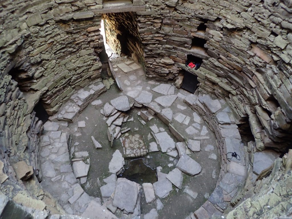
64. Inside the broch there was a well on the floor level. Chambers for storage were built into the walls which were perhaps 3-4 metres thick at the base before the two concentric walls rose from them.
I was overwhelmed and quite emotional to be in the broch and see it in its nearly complete glory. It is interesting that this Broch is so similar to the ones in Lewis or Sutherland or Glenelg or Orkney despite the distance between these places 2000 years ago. It was as if there was a building blueprint and craftsmen followed its plan, like today’s builder would an architect’s drawing. After a good hour exploring the broch I had to leave to continue the tour.
I went past a ruin where the last inhabitant of Mousa lived and farmed up to 1840, when she died. The stone of her old laird’s house looked similar to the broch and it looked like it was quarried from the hard sedimentary stone of the bedrock by the shore. The southern hill of the island was mostly grassy pasture with little feature, but I heard many snipe drumming and it seemed great skuas nested here.
As I carried on round to the SE corner I came across two remarkable Pools, West Pool was the bigger and East Pool the deeper. They were large inlets with a mantle of beach and marsh around them. At high tide they were connected to the sea while at low tide they were separated. The larger West Pool was perhaps 250 metres wide and 500 metres long. Between the pools and on each side were grassy peninsulas and I could see geese fleeing me even though they were 500 metres away. One can see why they make good guard animals with their sensitivity. There was also a tern colony here in the stony edge of a peninsula with perhaps 1-2000 birds. They were busy attacking any intruder and even the Great Skuas got chased out by 10-20 fearless terns.
The two pools were a haven for wildlife and in the larger West Pool common seals have their pups in June and then rear them in the sheltered protected waters. But I could not see any. There were many eiders here with rafts of young. The geese which were here had all fled to the other side and over the peninsula. Sheep also gathered on the sandy waters edge to eat seaweed. In the smaller East Pool seals come ashore to molt in July but I did not see any here either. There were a couple of red throated divers here and they came quite close. The divers would not be breeding on the island though.

66. Red Throated divers feed in the sea but nest on fresh water lochans with small islets of vegetation. Here are a pair on the East Pool of Mousa , a sea inlet.
I returned to the bothy past East Ham beach where the surf was crashing, but there was an inner sanctuary to the bay where it was calm. The West Ham was the better harbour in any east wind direction. The coast here was full of Oyster catcher and plover. When I got back to the bothy after the 2 hour, 5 km walk I was hungry. It was already 2130 yet the sun was still up and warm. I brought my stuff up and left it outside and I cooked outside making sure it looked like I would be staying out. Then I opened the bothy and set up the table and chair in front of the door to write with an eye on the sea in case I needed to make a quick exit in case a warden came.
I wrote for a good hour enjoying the comfort and ambience of the evening and was in a world of my own when suddenly the Mousa Boat appeared. Panic spurred me into action and within a minute I had vacated the bothy, locked it, and was sitting on the bench writing when the boat pulled up and started to unload some 40 punters. They gathered around me and the place stunk of soap, perfume and eau de cologne. It was an awkward stand-off as I think they looked to me for advice, while I ignored them, their inane jokes about “rowing over”, and their fine smells. It turned out there was no warden with them, just the boat skipper and his crewman who had charged them to transport them over to see the Storm Petrels. After they had secured the boat they came up and the skipper cajoled his flock into a circle to explain safety concerns and then led the sheep towards the broch. I chatted with the crewman and said I would follow him over in half an hour. It was quiet when they had gone but I felt the serenity of the island had been violated.
It was 2300 when I got to the broch and heard the skipper read out his fact sheet on Storm Petrels without any wit or flair. Apparently they can live for 25 years and pair for life, returning to the same nest in a rocky crevice every year. Mousa has about 10,000 pairs with 500 on the broch alone and another 1500 between the boulders of the roped off beach. They lay eggs in June, chicks appear in July and the young fledge in August and then they all migrate to African or Indian Ocean waters in Late September. Once the eggs are laid they take it in turns, with one parent at sea for 3-5 days and one on the nest in the stones. The changeover is a vulnerable time for them so they do it at midnight.
As it approached midnight the skipper noticed a few but said it would be late due to the bright evening. We could hear them calling their partners from the crevices but none were coming. Apparently they would be in rafts, just offshore out of predators’ reach, waiting for darkness. The chirping from within the broch walls got louder and then suddenly I noticed one. It could have been mistaken for a bat such was its speed and darting flight. It went to a hole, paused for a few seconds and then went in.
By 0100 in the morning the punters all left and walked back to the boat while I could stay alone. By 0130 it was as dark as it was going to get and the changeover started in earnest. I could not see what was happening on the beach but around the broch it was swarming with Storm Petrels. They were swirling round and round looking for their partner and the right hole to go into. Once they were sure they would land on the lichen and then flutter up to the crevice entrance and quickly disappear inside. Eventually its mate would come out and dart out to sea. By 0200 I had seen enough and was tired after my long day so headed back to the bothy and prepared it for the night. I slept on the slightly grubby mattress in the still warm bothy and fell asleep at once. It had been a long but fascinating day. Perhaps the best all round day of the trip so far with 2 walks, a demanding paddle and the broch with its history and petrels to top it all off.
Day 27. July 01. Mousa to Eastshore.17 km. 3.5 hours. I knew the Mousa boat would not be back until 1100 in the morning so there was no hurry to pack up and go. There was very little to pack as I slept in the bothy. I had a calm breakfast sitting on the bench outside in the sun. Then I manoeuvred the kayak down some planks to the waters edge at this low tide. A seal sauntered into the bay hoping to pull out but saw me and moved on. I eventually set off at 1000 and paddled out of the West Ham bay and down the coast to the massive, solid broch again. It stood proud and defiant on top of the small grassy mound above the coastal outcrop as it had stood for 2000 years.
Beyond the broch the a hard finger of the Mainland, called No Ness, which jutted out into the North Sea. I could see breaking surf washing at its base, sometimes with large explosions of spray. The NE swell of yesterday had obviously not diminished in the night. There was no reason it should have done as the wind was still a good force 5. The further I paddled away from the lee of Mousa island the more I realized I was going to have a bumpy ride today down the coast. More and more white caps were appearing and soon they were everywhere. As long as it stayed like this it should be OK, but if the wind ramped up a notch it would start to get increasingly uncomfortable. At the headland itself, at the base of the cliffs the sea became very choppy. It was obviously to do with the tide and I guessed it would be going south as it ebbed, but it was going north. As the tide piled into the swell it steepened the swell causing them to slow down and topple over. It was only a 100 meter section but it was an exciting patch. The waves had slowed down enough so I could surf them and I surged round the tip, struggling to keep the kayak pointing in the right direction as it constantly wanted to broach.
With a little relief I surged into the lee behind No Ness. There was nowhere to pull in here as it was all cliff so I crossed the bay over to the next headland. Again I was initially in the lee of No Ness peninsula but soon I was out in the North Sea again with the swell piling out of the NE behind me. I eventually reached the Shetland Mainland at the rocky headland of Troswick Ness. Here I had to repeat the wind against tide rollercoaster for a few hundred metres. I had to be careful here as I could see many darker patches in the turquoise sea. These were shallow reefs and shelves, and occasionally a larger swell would erupt over them. Sitting upright I threaded a path through them and then surged in on the surf in the calmer waters south of the headland supported by its ring of cliffs.
There was a small detour here to a bay, Tros Wick, which was sheltered from the wind and swell. I had not been paddling long but was already half way on this short day so decided to pull in. The large leaves of the brown oarweed were glistening in the sun, still wet from where the low tide had recently exposed them. I paddled through the floppy strands to find a rocky shelf on which to land and stretch my stiff legs. I realized it was the first time I had been on the Mainland since the beautiful sandy isthmus at Uyea some 2 weeks ago. Since then I had just been on the islands.

67. The cliffs from Troswick south to Voe were impressive with arches, small caves and stacks. These continued down the coast to a lesser extent from Voe to Sumburgh
After the break it was back onto the exposed coast. A near continuous line of cliff extended south for nearly 2 km, some overhanging and with a smattering of arches and caves to enrich their grandeur. Again it was a bumpy section and it was only when I got to the large opening of Voe did I get some shelter. It was short-lived and I was soon on the final stretch, a 3 km section of cliffs and jagged headlands. These were also lively and I had to keep a little out to avoid the submerged skerries and clapotis rebound of the cliffs. It would have been an interesting paddle in calm conditions as the coast was full of natural features.
After half an hour the cliffs, which had been gradually diminishing, disappeared and I got to a shallow headland with an inlet beyond. There was a roaring in the sky and a plane suddenly appeared on the rocks in the middle of the inlet. It was the reclaimed runway of Sumburgh Airport which extended into the inlet to allow larger planes to use the airport. I headed west up the inlet between runway and pastoral fields for 10 minutes until the breakwaters of the protected marina appeared. I paddled between their embracing comfort and up beside the small fishing boats to the slip to complete my circumnavigation of Shetland after 410 km. I landed on the slip and pulled my kayak up the weed covered concrete until it was dry. Then put the trolley together and heaved the laden kayak up to flat ground and rummaged around for my car keys. Luckily the abandoned car, which had been standing for a month, started. It took nearly two hours to sort everything out, load the car and find my clean clothes.

68. The marina at East Shore by Sumburgh where I started and finished the tour 410 km later. The “mast” on the kayak is actually an airtight drain pipe for a camera mount.
I then looked at the weather forecast. I needed a 3 day spell of exceptional weather to tie up the loose end of paddling out to Foula, which I had to skip previously as the weather was not good enough. However there was no weather window coming up to do this, so I threw in the towel and phoned Northlink about the possibility of a ferry that evening. There was one but I would have to go on the passenger ferry, while my car would have to go on the freight ferry. They were both leaving in about 3 hours and would both arrive in Aberdeen the next morning at about 0700. There was no space on the ferries for the next 2 days. It seemed too good an opportunity to miss. 3 hours later I was washing half a week’s worth of salt off in the cabin shower.
As with many trips the much anticipated end was a bit of an anticlimax. The marina at Eastshore was deserted when I pulled in so the first person I spoke to was the ferry check in officer in Lerwick and I never mentioned I had been kayaking to him. It would have been nice to go and see Malcolm and Val at the Brae hotel or Paul at Hillswick hotel, both of whom looked after me so well, or explore North Roe and meet up with Wendy and Barry who I met nearly 3 weeks ago but there was no time for that now. However, I had really enjoyed the spectacular grandeur and menace of the Shetland coast. Combined with the many walks I had done on the windy weather days I had seen many aspects of Shetland, it’s coastscape, wildlife and even some of its history, and sure I will cherish them in the future as precious memories.