Trans Africa Cycle / Gallery
Section 10. East Central Tanzania
-

- 693. Looking east across the vast Kilombero Plain to the hills on the other side. Each edge of the plain was cultivated but the centre with the flood prone channels was the real of wild animals.
-

- 694. East of the road were many villages before the agricultural land on the Kilombero Plain. There were many vegetable nurseries here bring on seedlings to transplant.
-

- 695. The Udzungwa Mountains rose steeply on the west side of the road for most of the day. Much of it was a national park.
-

- 696. There where many villages between the road and the corporation farmed sugar cane fields south of Ruaha. Most looked similar to this.
-

- 697. The vast corporate sugar cane fields where part of a huge plantation and a sugar cane factory near Ruaha.
-

- 698. North of Ruaha the Udzungwa Mountains started to diminish and the sugar cane grew on their lower slopes. I think these were individual cash crop farmers growing it here.
-

- 699. There had been baboons along the road all day but as I climbed up a jungle clad valley to the plateau where Mukumi lay the baboons became more numerous.
-

- 700. At the entrance to Mikumi National Park there were many signs encouraging drivers to keep their speed down for the next 50 kilometres.
-

- 701. There were quite a few giraffe in Mikumi National Park. This group of 4 were beside the road near Mikumi town
-

- 702. The were many baboons beside the road in the Mikumi National Park looking for discarded food I think. The were quite traffic savvy and quite confident when I went past.
-

- 703. There were also quite a few gazelle in the park and I alo saw wildebeast and buffalo a little distance from the road.
-

- 704. At the east side of the park nearer the town of Doma I saw 10 giraffe sheltering from the sun under the canopy of a vast tree.
-

- 705. Leaving Doma for Msongozi i initially passed through a strongly muslim village where there was a lot of vegetables grown, especially tomatoes.
-

- 706. The smaller village, I think called Kibungo, which was just west of Msongozi. The village was friendly and there were some Maasai herdsmen here.
-

- 707. The larger village of Msongozi was based on irrigated agriculture and also the tall legumes bushes producing “pigeon peas”. It was quite remote with the way I had just come for 14 kilometres as the lifeline to the world.
-

- 708. My rural sojourn came to an end at Melela Mlandizi where there was a small roadside town through which the main T1 road and all its traffic passed. I had to follow the T1 for 10 kilometres next.
-

- 709. After 10 kilometres on the main T1 road I could escape again and go down to Kipera and along the base of the mountains on an older minor road for 30 kilometres to reach Morogoro city.
-

- 710. On the route down to Kipera on the earthen road I passed a few hamlets and fields and some coconut groves.
-

- 711. Before reaching Kipera I passed coconut groves under which were large fields of irrigated maize watered by hose from streams coming off the adjacent Uluguru Mountains.
-

- 712. Passing through Kipera under the Uluguru Mountains my hopes were raised by a lovely tarmac stretch but this soon reverted to bumpy dirt for another 15 kilometres all thr way to Morogoro city.
-

- 713. The lovely tranquil gardens of the quiet Mama Pierina hotel in the middle of Morogoro was an easy place to spend a rest day before the final push.
-

- 714. Leaving Morogoro city and looking south towards the high jungle clad peaks of the Uluguru Mountains.
-

- 715. Leaving Morogoro and looking north over some homesteads to the flat drier savannah.
-

- 716. To the east of Morogoro there were some hamlets blessed with streams and springs from the Uluguru Mountains which allowed farming, even rice farming, throughout the year.
-

- 717. The track through the village of Pangawe to the east of Morogoro and halfway between it and joining the busy T1 main road.
-

- 718. I had to cycle along the T1 main road for about 43 km between Mkambarani and Ubenazomozi. The real problem was not the well driven trucks but the long distance buses and the 4×4, especially those with government number plates.
-

- 719. Beside the T1 main road there were many market places selling fruit and vegetables all stacked in pyramids with colourful ladies at the stalls.
-

- 720. At Ubenazomozi I left the main T1 main road and headed NE on a small road. At Ubenazomozi I stopped for a chip omelette in a local cafe.
-

- 721. The small dirt road from Ubenazomozi and Lugoba was about 30 kilometres and very rural with a few remote villages, mostly of cattle herders.
-

- 722. The architecture of the herders houses between Ubenazomozi and Lugoba was different and it was mud daubed on a wooden framework. The were few brick houses on this stretch.
-

- 723. At Lugoba I left the small gravel road and joined the T2 highway. It was much quieter than the T1. I followed it for 15 kilometres in all.
-

- 724. From Msata to Bagamoyo I followed the T35 highway for 65 kilometres. It was quite a fast road but had a tangible verge.
-

- 725. The villages beside the T35 showed more and more of an Islamic influence with more mosques than churches and many people in Islamic dress.
-

- 726. There was some agriculture around the villages and grazing between them. Here are pineapples growing under teak trees growing under coconut trees at Kiwanga village.
-

- 727. Towards Bagamoyo the road crossed a number of rivers and grazing areas between them. The were a few herds of the Sangea type breeds about with large horns wich the Maasai favour.
-

- 728. There were also many rice fields between the rivers and these fields looked like they irrigated so could produce rice throughout the year not just in the rainy season.
-

- 729. On the beach at Bagamoyo there were lots of small dugout outriggers and larger boats which fished the more protected waters of the Zanzibar Channel between Bagamoyo and Zanzibar Island.
-

- 730. After 5639 kilometres and 40340 metres of ascent I finally reached the Indian Ocean having left the Atlantic Ocean and crossing Africa in 119 days.
Section 09. West Central Tanzania
-

- 580. Climbing up the ridge towards Tukuyu on the main road quickly took me out of the valleys below and I got great views of the distant forested hills.
-

- 581. The homesteads were much more substantial here with high corrugated iron roofs and productive vegetable gardens around the house.
-

- 582. Many of the homesteads also grew tea in addition to cassava, maize beans and bananas. They would sell the tea to the tea factory supplement their income.
-

- 583. Near Tukuyu was the Kyimbila Tea Estate which looked like it was well managed, especially compared to the neighbouring Chivanjee Estate.
-

- 584. Between Tukuyu and Kiwira there were near continuous homesteads and clusters of hamlets. This is the scene just leaving the outskirts of Tukuyu.
-

- 585. Many homesteads also grew tea between Tukuyu and Kiwira but there were larger areas growing bananas and beans.
-

- 586. The beans which seemed to grow everywhere were similar to kidney beans.
-

- 587. On the way up the endless climb from Kiwira to Isyonje i passed many banana groves at the beginning some with a lower tier of crop like coffee here.
-

- 588. The homesteads were all surrounded by banana groves, potatoes plots and bean fields. Beyond the homesteads was green forest on the hillsides
-

- 589. Halfway between Kiwira and Isgonje there were more and more farmers with potatoes and many were harvesting them.
-

- 590. The village of Idweli was just before Isyonje and you can see the roof designs clearly with the tall roofs
-

- 591. On the climb between Kiwara and Isgonje the road had a small verge. Motorbikes are the common mode of transport, here with two baskets of chickens.
-

- 592. As I cycled up to Isyonje potatoes became not only the dominant crop but the only crop.
-

- 593. After the T junction at Isyonje I took the small bumpy dirt road up the crest only the ridge to Igoma (pictured) and beyond onto the Kitulo Plateau.
-

- 594. The penultimate climb from Igoma to Kikondo was about 400m of ascent on a rough dirt road in the forest.
-

- 595. The final push up the last hill at the end of the day to reach the potato fields and village of Kikondo where I spent the night.
-

- 596. Looking south of the main ridge on the lip of the Kitulo Plateau down the escarpment slope to the Rift Valley some 2500 metres below.
-

- 597. The Giant Groundsel, Dendrosenecio, spieces I saw at about 3000 metres in the mist. They are prolific on the bigger mountains of East Africa like Mt Kenya, Kilimanjaro and Ruwenzori.
-

- 598. A protea species on the top of the Kitulo Plateau. This Plateau is sometimes called the Serrengetti of Flowers and is ablaze with 350 types in the rainy season from November to March.
-

- 599. On the way down the east side from the Kitulo Plateau I came a Ross a large ranch with 500-1000 Holstein-Fresian cows. In the distance are white potato bags on the hillsides.
-

- 600. On the hillsides and valley floor around the villages of Ujeni, Kitulo and Nkenga every piece of land was devoted to the potato.
-

- 601. Looking across the segmented Bhutan Pine plantations interspersed with maize fields to the distant village of Makete, where I should have been.
-

- 602. The trees are cut where the grow and then are planted into lumber where the fell before being carried to transported to the roadside for a small lorry to collect them.
-

- 603. One a small lorry picks up the lumber and planks it is taken to a village like Ivalali or town like Iwawa and stacked as part of the curing and drying process.
-

- 604. The town of Iwawa was pleasant with wide, clean streets and a variety of shops for many trades. It had a planned feel to it.
-

- 605. The view to the hills around Iwawa. The land is cultivated right up the hillside and between the stands of pines grown for lumber.
-

- 606. A good view of some of the homesteads showing the house architecture and how the homes are surrounded by maize fields.
-

- 607. Looking down the valley from below Iwawa towards Ikonda where I was heading. You can see how much lumber is grown here.
-

- 608. At Kisinga there were large stacks of lumber. Every roadside village had huge stacks of lumber drying. None was locked and secured showing how Tanzania is relatively crime free.
-

- 609. As I descended below 2000 metres potatoes pretty much vanished and maize returned as the staple crop.
-

- 610. It is difficult to overestimate just how much lumber is stacked up in the villages. This was one of many piles in the village of Lupalilo near Ikonda. It was all plantation grown.
-

- 611. The view from the peaceful garden of the Udiakonia Lodge. It was part of a Lutheran charity which helped disabled people to aquire skills to practice in the villages around here.
-

- 612. The brass band and the choir at the Udiakonia Centre at Ikonda at the celebratory meal I was invited to.
-

- 613. The whole Udiakonia Centre and project was due to the warm-hearted Fidus, with help from the congregation of the Neuhausen Lutheran church near Stuttgart.
-

- 614. The guesthouse at Udiakonia was arranged around a lovely internal courtyard with all the rooms facing off it. This is a view in the early morning.
-

- 615. The giant lobelia were a seldom seen sight today at some of the higher passes. The two in the foreground with purple tinged leaves are ready to flower while the tall spike is the flower.
-

- 616. A view down one of the valleys from one of the passes near Ikonda. A lot of the hillsides here were covered in forestry plantations of Bhutan Pine.
-

- 617. Between the higher passes were saddles and ridges were the was a lot of farming. It was mostly maize but there were also many fields of wheat.
-

- 618. Nearly every homestead had a tree in blossom. I think they were apricot trees, but there are also apples in the area
-

- 619. Throughout the day there were many yards of lumber drying and the hillsides nearer Njombe I felt were in danger of being over harvested.
-

- 620. At many of the lumber yards men were restacking and loading or unloading lorries. The price of the lumber rises in the rainy season as harvesting is minimal then.
-

- 621. At the larger roadside village of Kepengele I stopped in a local restaurant for rice, vegetables and a bean stew. It usually costs about 3000 shillings or £1 and is simple and healthy.
-

- 622. The 3 wheeled motorbikes with a tipping trailer behind the driver are a common form of transport and are frequently moving sacks and goods around. Here is one having the tipping trailer cleaned
-

- 623. The town of Njombe was capital of the region with the same name. It was much bigger than I expected with a population of about 200,000.
-

- 624. In NNjombeI saw a few saws like this one which are attached to a diesel engine with a belt to turn a circular saw blade. It was undoubtedly similar to the portable sawmilIs heard in the forest making the lumber.
-

- 625. Njombe had a few covered markets. This one was selling a large variety of vegetables and dried beans. There misy have been 5-7 different type of fresh vegetable in this dry season.
-

- 626. In the same covered vegetable market there were many different types of beans and pulses. There were perhaps 15-20 different varieties of beans.
-

- 627. Passing the large tree plantation after leaving Njombe on the road to Lupembe. The trees were mainly eucalyptus like this dense stand, but also Bhutan Pines and Grevillia
-

- 628. After the dull plantation on the flat plain east of Njombe the landscape started to have a bit of character from Kidegembe village eastwards.
-

- 629. The road was packed red earth with a lot of rubble type stones embein it. It was quite dusty and not as smooth as it looks.
-

- 630. The large village of Matembwe was where I intended to stay but I could not see and I liked so decided to carry on to Lupembe.
-

- 631. Between Matembwe and Lupembe the road passed quite a few small tea fields which the farmers grew as a cash crop. The trees are grevillia and are for shade.
-

- 632. One of the many churches in Lupembe. This simple one will no doubt be a beacon of happy singing on Sundays.
-

- 633. Looking back up the hill to Lupembe after leaving it on the way to Madeke.
-

- 634. The Lutheran Church at Lupembe was built in 1890 and is the oldest church in the whole Njombe Region.
-

- 635. The village of Igombola with the Lupembe Tea Factory located on the hill above it.
-

- 636. Passing a small cash-croppers tea garden and a recently harvested and planked in situation eucalyptus patch between Igombola and Mfrika.
-

- 637. Looking north down one of the side valleys from the ridgetop between Igombola and Mfrika which the track tries to follow.
-

- 638. Some of the individually owner tea garden plots at Mfrika which are grown as a cash crop to sell to the Lupembe Tea Factory. These buildings looked like they were from the colonial era.
-

- 639. Looking back down to a hamlet beside Mfrika with the track winding along the hilltop ridge back to Igombola and Lupembe.
-

- 640. On the ridgetop track between Mfrika and Madeke. Virtually none of this track was flat. It was either steep up or steep down.
-

- 641. Looking back towards Madeke after leaving it in the morning for the arduous journey to Taweta. You can see fields of pineapples here and there.
-

- 642. Looking east along the ridge leading out from Madeke with the taxing track running along its apex from knoll to knoll through fields of pineapples.
-

- 643. There were also orchards of mango and avacado beside the ridge top road leading east from Madeke to Taweta.
-

- 644. Most of the pineapple groves were small and manageable by a family. However, there were some farms like this one with a larger farmhouse where the owner employed labourers to work on the larger farms.
-

- 645. The pineapple crop on the road between Madeke and Taweta was just starting to ripen but there were some bushes already producing mature fruits.
-

- 646. The track between Madeke and Taweta was very convoluted with plenty of steep descents and climbs but generally it dropped down the ridges to the flatter lands in the distant east.
-

- 647. Before it reached the flatter lands to the east around Taweta it passed through a very poor village lost in jungle and only connected to the outside world by this rough track.
-

- 648. Once the track had descended out of the hills it passed a couple of small hamlets in the flatter valleys before reaching the Mnyera River and the very small town of Taweta.
-

- 649. The Mnyera River drained the area to the north of the ridges i had been following for the last 3 days since Njombe. It was one of 4 large rivers which flowed onto the flat Kilombero flood plain where I would be for the next 4 days.
-

- 650. The very small town of Taweta had a couple of local restaurants on the main street, a secondary school and two lodges, one being attached to the mission station. One restaurant is on the extreme left.
-

- 651. After leaving Taweta I immediately crossed over the Mnyera River which drained the northside of the ridges I had been on for the last three days.
-

- 652. Between Taweta and Ipinde the track went alongside valleys where the were some poorer homesteads with banana groves and some maize and rivers plots being reclaimed from the encroaching jungle.
-

- 653. After Impinde track went through some thicker areas of jungle where the track was very rutted and near impassable in the rainy season I should imagine.
-

- 654. After the jungle section following the village of Ipinde the track crossed a few ford which flowed over the track on concrete ramps.
-

- 655. As I approached the village of Mpanga the rice fields became more organised and established as if they had been there for a generation or two.
-

- 656. In most rice areas the farmers have a nursery where the rice shoots are planted and nourished before being uprooted and taken the the prepared main paddy fields where they are planted much further apart and in rows to mature
-

- 657. Before Mpanga the rice paddy fields disappeared as the track left the flat valley for shallow hillsides and the homesteads became poorer as they relied on maize and cassava.
-

- 658. The dusty town of Mpanga was thr main market town for about 10 kilometres in each direction.
-

- 659. I was passing more and more Maasai herdsmen with small herds of cows. This herdsmen passed me on the bike carrying a live sheep across his shoulders.
-

- 670. Entering the town of Mlimba which was the largest town with the most amenities since leaving Njombe four days ago.
-

- 671. Leaving Mlimba and looking north west to the start of the Udzungwa Mountains which quickly approached the road and formed the NW boundary of the large Kilombero Plain and wetlands.
-

- 672. Looking east on the road leaving Mlimba across the start of the vast Kilombero Plain and wetlands which was about 200 kilometres long and 40 wide and hemmed in by mountains on each side.
-

- 673. As I approached the Kihansi Dam offices and social club 20 kilometres NE of Mlimba the Udzungwa Mountains were now right beside the road and covered in jungle.
-

- 674. Approaching the village of Udagaji whose main street and adjacent homestead compounds where heavily shaded by large trees, mostly mango.
-

- 675. There were frequent rice mills where the rice was dehusked by machine all the way along the road every two kilometres or so showing how much rice was grown on this part of the Kilombero Plain.
-

- 676. At Udagaji the kids were much more forthcoming and wanted to be photographed.
-

- 677. The homesteads continued all the way from Udagaji to Chita with many shaded by trees and palms. Here are coconut and palm oil palms (the shorter) and a mango trees. There were banana groves everywhere. The main farming was done on the adjacent Kilombero Plain.
-

- 678. Leaving Chita in the morning and heading NE along the edge of the Kilombero Plain with the Uzungwa Scarp Nature Forest Reserve rising steeply to the NW.
-

- 679. At Ikule I was spotted taking a photograph by these kids who burst into an excited run and followed me for about 2 kilometres all the way to their school.
-

- 680. North of Ikule I passed these three characterful ladies selling bananas and ripen payaya by the roadside and stopped to buy some.
-

- 681. Around Mngeta village the dusty road veered onto the flat Kilombero Plain and away from the mountains but the streams from the mountains still flowed and irrigated large areas of vegetables like the pictured tomatoes.
-

- 682. At the village of Njagi the homesteads where lush with irrigation and idyllicly situated at the foot of the mountains. The palms here are oil palms.
-

- 683. Starting to enter the edge of Mbingu which was a thriving market town and it seemed this was where the lorries dropped their loads which were then redistributed to smaller lorries by traders serving the villages on and along the Kilombero Plain.
-

- 684. Just outside Mbingu was a Spritual Retreat run by the Fransciacan Sisters who lived and were based in a large adjacent complex housing 1000 nuns.
-

- 685. One one the quiet peaceful verandahs in the Mbingu Sister’s Spiritual Centre where I spent the rest day writing.
-

- 686. The central building in the Mbingu Sister’s Spiritual Centre had been commandeered as a prayer room by the Catholic priests and clergy who left in the morning after a few days retreat.
-

- 687. The unnamed river which drained an arc of the Udzungwa Mountains a little to the north. It crossed the road some 5 km east of Mbingu.
-

- 688. The digging hoe is the main farm implement I have seen in the Central and East Southern Africa. The next most popular is the slasher for clearing land.
-

- 689. The homesteads here were not so sheltered from the sun and where not so overhung by large trees.
-

- 690. The Maasai cattle had huge horns with some bulls having a tip to tip span of over two metres.
-

- 691. As I got closer to the regional capital of Ifakara the landscape got drier and the maize and rice crops were not irrigated and would only thrive in the rainy season.
-

- 692. St Andrew Catholic Church in Ifakara seemed to be the main Catholic church in the region and had connections to the Mbingu Convent and Retreat and also the St Francis Hospital in Ikafara.
Section 08. North Malawi
-

- 531. The lush fertile farmland of the plain before the climb started. The homestead is surrounded by large mango trees.
-

- 532. At Mpamba just at the start of the climb there was rice laid out on tarpaulins on each side of the road. It was to dry it completely before dehusking it at the pictured adjacent mill.
-

- 533. The small town of Mpamba was typical with small shops, mostly grocers, back from the road and market stalls in front of them, allways with tomatoes, beside the road.
-

- 534. As I climbed the road tended to follow the main ridges. On each side were side ridges and valleys where homesteaders farmed on steep ground and lived on the ridgelines.
-

- 535. The digging hoe, or mommaty, is the farmers main tool. It is swung into the earth and then the chunk is pulled towards you turning it over.
-

- 536. The two clerics at the Ekwendeni CCAP mission church and guesthouse. The sign they are holding is the 100 year celebration of when the various presebytarian synods of South Central Africa merged.
-

- 537. The supposedly 150 year old CCAP church in red brick in Ekwendeni. When I arrived there was a service with singing bursting out of the windows.
-

- 538. The stained glass windows might have been made in Scotland and shipped over in the earliest colonial times. There are a few Scottish names mentioned at the bottom and these were perhaps the founding ministers.
-

- 539. Inside the CCAP church at Ekwendeni which could probably seat at least 500 worshipers and singers during a service on the wooden pews.
-

- 540. The early morning service at 0730 in the packed church at Ekwendeni. One choir were on the yellowish dresses at the front. The other choir is out of sight.
-

- 541. The red earthen road between Ekwendeni and Engucwini was easy to cycle and took me through less verdant homesteads.
-

- 542. To the west of the track were tobacco and maize growing homesteads and then the hills which rose to the west which eventually led up to distant mountains.
-

- 543. To the east of the track were more homesteads which stretched out onto the plains where the busier M1 road I was trying to avoid was.
-

- 544. The well respected Bright Chirwa on his old bike in Kacheche village where he went to support his village’s football team.
-

- 545. The small social track between Kacheche and the tarmac road near Rumphi was great on a bike but occasionally sandy.
-

- 546. This young woman was only about 14 yet was quite happily carrying 15 litres of water on her head taking it from the communal bore hole to her homestead.
-

- 547. Just east of Rumphi the South Rukuru River tumbles through a narrower valley before spilling out onto the plains beneath the mountains to the west.
-

- 548. Looking west from the road between Rumphi and Mhuju to the western edge of the plains where they meet the mountains which rise up into the Nyika National Park.
-

- 549. Tobacco is the cash crop in this area and virtually every homestead grows and dries it. It is then sold and the leaves are squashed into bales using presses with a screw plate.
-

- 550. The pressed dried tobacco leaves are squeezed into steel crates and then wrapped in hessian cloth to form a square bale which must be about 100 kilos.
-

- 551. Nearly all the larger hamlets and all the villages now have a maize mill for turning the kernels into flour to make nshima.
-

- 552. The kids are everywhere and very excited to see me. Whenever I take a landscape photo I am soon surrounded. As the kids in North Malawi are less likely to pester for money I can relax more with them and lend them my sunglasses.
-

- 553. After the village of Haniniya a significant climb started up to Livingstonia. As I climbed I could look west across mountain hamlets on the eastern edge of the Nyika National Park which largely grew tobacco, cassava and maize.
-

- 554. Some of the homesteads on the edge of the Nyika National Park were remote and without road, but most had electricity to them. The land must be lush and well watered for them to preserve growing crops on these steeper hillsides.
-

- 555. Old motorbike tyres are the favoured toy to practice skills on and have taken over from the bicycle wheel and hooped wire a generation ago.
-

- 556. At the top of the 400 metre climb i had some flat respite before the final 100 metre climb to the small plateau on which Livingstonia sat on top of the pictured hill.
-

- 557. The Livingstonia University was set up by Robert Laws, a Scottish Missionary in the 1890’s to train Africans in engineering, entrepreneurship, bookkeeping, teaching and the ministry.
-

- 558. The Livingstonia Mission Church was built by Scottish Missionaries, notably Robert Laws who ran the whole mission at Livingstonia for over 40 years.
-

- 559. The stained glass window in the the Mission Church at Livingstonia features David Livingstone and his 2 trusted companions Susi and Choma (to the right).
-

- 560. The cabins at Livingstonia next to the Stone House were quite simple. Just to the left was a long steep slope down rge escarpment so they had a great view.
-

- 561. The main building at the David Gordon Memorial Hospital at Livingstonia was set up 130 years ago by Scottish Missionaries and still operates.
-

- 562. The dining room reception and relaxing area of the Mushroom Farm which was built right on the edge of the escarpment overlooking Lake Malawi.
-

- 563. Starting to head down the track descending the escarpment. Livingstonia is on top of a further rise on the right and out of the photo.
-

- 564. Half way down the 30 something hairpin bends of the track looking back to the cliffs on which the Mushroom Farm sits.
-

- 565. One down on the lakeside M1 main road at Chitimba i passed a few fishing villages with millions of net caught fish drying in the sun on racks.
-

- 566. After Chitimba there were a few rice growing areas where the muddy paddies had already been prepared and young grass shoots were being planted.
-

- 567. St Anne’s Church was part of a Catholic Mission originally started by nuns in 1948. It comprises a secondary school, small hospital and this church.
-

- 568. Stephanie (father) and Rei (son) are a team of well seasoned African bike packers and this year were cycling from Uganda to Mozambique.
-

- 569. Ngara is a fishing village and harbour with a thriving industry in netting cichlids and drying them on racks in the sun.
-

- 570. Malawi is full of good natured kids. They are all quite confident and well socialised and they must be well nurtured in their homes and villages. No one has a normal pose and they all like to show off with the camera.
-

- 571. Well to the south of Karonga near the village of Mulale were two lagoons which were separated from the main lake with a drift of sand which now has trees growing on it. There was a lot of grazing nearby.
-

- 572. Between Ngara and Karonga it seems most of the farmers have let their fields run riot and they have not been cultivating them in the last year.
-

- 573. Beside the Mikoma Beach Lodge was an active fishing village with boats and dugout canoes landing their catch of cichlids.
-

- 574. Approaching Karonga the road was busy with pedestrians, cattle and motorbikes but relatively few vehicles.
-

- 575. North of Karonga the agriculture was much more vigerous with all the flat lands beside the rivers irrigated and ofter planted with fields of rice.
-

- 576. Where there was no irrigation the field were fallow and would probably remain so until the rains came in November when they would be planted with rice.
-

- 577. In the rice growing areas the homesteads were much more substantial and better built showing how rice is much more profitable than maize.
-

- 578. Frequently there were areas of irrigated fields with rice growing in them next to fallow fields with livestock grazing them. The cowherds must gave a difficult job making sure they dont encroach onto the verdant rice shoots.
-

- 569. After the border on the Tanzanian side the agriculture looked very organized and these plots of maize must have been irrigated to thrive like this in the dry season.
Section 07. Central Malawi
-

- 462. The craggy outcrops on the border with Malawi. The border was on the watershed of the tributaries of the Luangwa River in Zambia and Shire River in Malawi. Ultimately both flow into the Zambezi River.
-

- 464. In Malawi brick manufacture was at least as prolific and artisanal as it was in Zambia with many homesteads involved in it.
-

- 465. The earth was much redder organised anything I had seen in Zambia and the land was extensively farmed with farmers living in simple brick houses.
-

- 466. The market town of Mchinji was a thriving and vibrant place even in the afternoon. I was able to get everything I needed here.
-

- 467. On both sides of the road were the fields of the homesteads. A few were getting tilled by the farmers, male and female, who were forming furrows with 90 bent spades.
-

- 468. Virtually every tree was living under threat of being made into charcoal to sell or burnt on the homestead kitchen hearth. Even this benevolent mango had been butchered.
-

- 469. An increasingly common sight as I cycled east was to come across younger men selling mice which you could buy for 600 kwacha (£0.25). Apparently they are best grilled.
-

- 470. The M12 road through Malawi went from the border by Mchinji to Lilongwe, the capital. There were quite a few smaller towns along its 120 km length.
-

- 471. The homesteads were now all made from bricks with some having a grass roof and others a corrugated roof, often covered with grass and bricksto keep it in place.
-

- 472. This field was one of a few which had already been tilled by the men and women of the homestead with a digging hoe or mommaty.
-

- 473. Around the town of Namitete there were many tobacco drying sheds where homesteaders dried their produce before selling it to a dealer.
-

- 474. At Namitete there was a huge concern with many hectares and thousands of trees growing macadamia nuts in a vast orchard
-

- 475. As I neared Lilongwe i passed more and more cyclists with huge stacks of charcoal. All were heading to the capital to sell their wares.
-

- 476. The Flame Lodge was in in the brick lined backstreets of Msundwe which were busy with women carrying water and livestock returning home after a day’s grazing.
-

- 477. There were quite a few of the more eccentric denominations on the road between Mchinji and Lilongwe. This was over and above the usual ones and the mosques.
-

- 478. The market town of Msundwe had small shops and stalls lining the main street. I hoped to stay here but the rustic Flame Lodge was full so had to continue.
-

- 479. After the totally charmless urban sprawl of the uninspiring Lilongwe, the capital city of Malawi, it was nice to be back in the countryside on the east side of it.
-

- 480. It was quite undulating on the farmed plateau with distant villages lost to the fast pace of change in the Western World and China.
-

- 481. The Lumbadzi River was one of many rivers which drained the plateau and flowed into Lake Malawi. It was still running with clear water in this dry season but you can see the raging torrent it must be in the rainy season.
-

- 482. On the hard climb from the Lumbadzi River to the village of Chankhungu I passed a near continual line of homesteads.
-

- 483. The village of Chankhungu where I spent the night in a rustic lodge. There was a vibrant market here as most roadside villages in Malawi.
-

- 484. The standard Malawi fare. Green vegetables called rep. The white maize meal called nshima and the goat stew which can be changed for chicken or fish, whatever is available that day. I often eat this twice a day and skip breakfast.
-

- 485. Even at 0700 in the morning the market in Chankhungu starting to bustle with vegetable saleswomen and a few men.
-

- 486. The hamlets and homesteads even beside the road are very poor and few have corrugated iron roofs with most having to make do with grass thrown on in an untidy manner.
-

- 487. Where the land was steeper the furrows were cut so they contoured the hillside to prevent erosion in heavy rain. Every 10 furrows or so there was also a large drainage bank to lead water off the hill if it overwhelmed the furrows above it.
-

- 488. Wherever there was water available the farmers planted neat vegetable gardens with tomatoes, potatoes, casava, onions, pepper and eggplants. Often it was watered by hand.
-

- 489. The beginnings of a brick. The homesteaders would start by digging piles of loose red earth and then wet it and stamp it into a paste as seen here. It would then go into forms and which would be tipped out to sun dry before being fired to harden.
-

- 490. The M14 road between Lilongwe and Salima with an excellent section of verge as it makes the final descent from the plateau to the plains beside Lake Malawi.
-

- 491. There were quite a few ponds and rivers on each side of the road between Salima and Nkhotakota. The rivers drained the plateau and flowed from springs to the west.
-

- 492. Some of the fields in the flatlands between the plateau and the lake were big enough to plough with a tractor which was hired from a cooperative.
-

- 493. I crossed a number of rivers between Salima and Nkhotakota, perhaps 7 in all, which flowed down from the plateau and were fed by springs as they flowed east into the lake
-

- 494. Since coming into Malawi I have seen quite a few signs for ‘doctors’. I would not hesitate to guess Dr Chiwanda is a traditional doctor specialising in witchcraft.
-

- 495. Whenever I stop kids come running up chanting ‘Muzungo’ and ‘give me my manny’. As a rule I dont photograph them but I already had the camera out and they insisted.
-

- 496. I stopped to have some fried sweet potato for lunch, dipped salt (top right) and flavoured with chilli sauce (top left).
-

- 497. As I passed the large village of Benga there were some large areas which were used to cultivated rice. The population was denser here with a strong Muslim presence.
-

- 498. The road was very variable between Salima and Nkhotakota with long good wide gravel sections waiting to be tarmacked and some excellent new tarmac. However there was also some pot-holed old road as seen here yet to be upgraded.
-

- 499. Nearly all the houses in Malawi had a balcony or verandah similar to this one at the least. I think shoes are not really allowed in the house and are left outside.
-

- 500. The closer I got to Nkhotakota the more mosques there were sometimes every 500 metres and they completely outnumbered the churches.
-

- 501. A tall pile of bricks covered in straw and mud insulation ready to fire with wood already in place in the channels at the bottom and more wood stacked outside to feed in once the first lot was burnt.
-
- 502. The beach just outside my cabin on the shores of Lake Malawi at Nkhotakota. It was windy in the afternoon so the waves were quite big.
-

- 503. A typical Lake Malawi fishing boat. These boats have 3-4 paddlers powering it or a small sail similar to a show, as pictured in the background.
-

- 504. Two fishing boats having just landed in the morning near Nkhotakota Safari Lodge. They are quickly surrounded by people with small bowls taking away the smallest fish.
-

- 505. The large flatbed lorry with the 3 cows and 5 goats tied up as the new farmers travelled with these purchases to a new farm they were setting up.
-

- 506. Following the undulating ridge as it dropped down to cross a river before climbing again. This is looking east to the lake as I headed north.
-

- 507. I stopped at one village mid morning for some fried cassava which seems to mostly be cooked by men and boys. The cassava was dried than the sweet potatoes.
-

- 508. To the east of the road there were some large fields of sugar cane owned by a company called Ilsovo. I did nor see cane crush factory but there must be one.
-

- 509. On the other side of the road with the sugar cane plantation was a plain were there was rice and cassava plots and fields.
-

- 510. As I neared Dwangwa I passed about 5 operations like this. I later found out they were brewing and distilling a spirit. The primitive set up with oil drums looks very suspect but apparently.
-

- 511. If the homesteads did not have rice or sugar cane they grew cassava, which is seen growing in front of the simple houses which are overshadowed by mango trees.
-

- 512. Just before Ngala was a fishing village on the beach with racks for repairing nets and drying fish.
-

- 513. Around Ngala and Kasitu the field to West of the road where well watered by streams and rivers and were ideal for rice cultivation.
-

- 514. One of the larger rivers and streams flowing from the mountains into the lake. I think this was the River Dwambazi
-

- 515. Looking west from the road to a cassava field. Note the huge mounds where sticks of cassava are taking root and which eventually grow into tuber bearing shrubs like those at the back of the field.
-

- 516. A field of maturing cassava in front of a homestead house surrounded my large mango trees. Behind are the green forest clad hills of the South Viphya Forest Reserve
-

- 517. After Chintheche the road climbed into the Ngazi Hills and was covered in a thick jungle like forest which was impenetrable.
-

- 518. After the thick forest around the Ngazi Hills but before Nkhata Bay the land had been cleared for and extensive rubber plantation with secondary timber production.
-

- 519. The busy junction above Nhkata Bay was a bustling market town. Lake Malawi was just 4 km to the east here down a steep road to the bay itself.
-

- 520. One of the dugout canoes on Nkhata Bay which were usually paddled by one as they fished in a more subsistence way.
-

- 521. The jetty at Mayoka Village Lodge, a reasonably priced lodge with a bohemian vibe made up from many rustic cabins and a central bar/dining/relaxing area.
-

- 522. The dining and relaxing area of Mayoka Village Lodge was very quiet and relaxing and right beside Lake Malawi.
-

- 523. Lake Malawi is home to some 800 species of cichlid fish and they are found round its shores. It is possible to spot many while snorkelling.
-

- 524. Unfortunately all cichlids and any other fish are caught by net from dugouts and fishing boats and then sold at market or consumed by the thousands of fishermen.
-

- 525. The markets are full of fish and here are some of the medium size spieces caught by the fishing boats.
-

- 526. Every market is dominated by tomatoes at this time of year. Sweet potato, greens, cassava, potatoes and onions are also sold now but tomatoes outnumber everything else put together.
-

- 527. There are vegetable plots wherever the land is flat and there is a stream or the lake nearby so they can be watered. Cabbage and greens are the main vegetables at the moment.
-

- 528. A view of Nkhata Bay with the first peninsula dividing the bay, and the town in two. Mayoka Village Lodge is at the end of the second peninsula.
-

- 529. A view of Mayoka Village Lodge with the cabins on the photo’s leftvand the bar/restaurant/relaxing area bottom right.
-

- 530. The sun setting over Nkhata Bay and the sun also setting on Section 07. Central Malawi for tomorrow I start Section 08. North Malawi.
Section 06. South East Zambia
-

- 377. Looking downstream from the Luangwe Bridge over the crocodile infested river.. Bridge Camp is about 3 km downstream on the right side.
-

- 378. Many of the houses on the homesteads east of the Luangwa River were made of wooden poles, or even bamboo.
-

- 379. I stopped at a shop called the Green Home Project 2020 where a grandfather ran the shop while his grandchildren played in the compound.
-

- 380. The Great East Road was very hilly to the east of Luangwa Bridge with lots of corners in the road to as it threaded a route through green forest clad hills.
-

- 381. Many of the homesteads between Luangwa Bridge and Kacholola were also made of woven bamboo which grew abundantly here.
-

- 382. The tailor just before Kacholola who repaired my stuff sack strap.
-

- 383. The row of simple restaurants in Kacholola. The all served the same thing which was maize meal (nshima), green vegetables, and then either chicken, goat or fish.
-

- 384. After leaving Kacholola the landscape started to flatten out a bit with less hills and the start of the plateau.
-

- 385. There were still some very traditional villagers and hamlets, often made from bamboo as the hills gave was to the plateau east of Kacholola
-

- 386. A view of the Great Eastern Road as it heads down onto the plain on which the town of Nyimba lies.
-

- 387. In the last few days I had seen a few mosques, but this one at Nyimba was the largest and looked quite active. It is a sign the east coast of Africa is approaching.
-

- 388. A man repairing the thatched roof on his mud brick built rondalval in the large traditional villages to the east of Nyimba.
-

- 389. There were many roadside stalls outside homesteads where farmers sold their sunflower oil in litre bottles. I think the oil was squeezed from the seeds in local presses.
-

- 390. The plateau became much flatter after Nyimba and the farming seemed to be easier. There were few trees here and virtually not charcoal for sale along the roadside
-

- 391. The ox cart was the villagers main form of transport for wood, hauling water drums back from the borehole pump and moving the heavy 50 kg sacks of maize and flour around.
-

- 392. Before the roadside village of Minga I met these two cyclists with at least 15 chairs each battling the wind. The truck and bus drivers were quite considerate.
-

- 393. A couple of the granitic “stocks” which protruded up from the plateau. They were scattered all over the place on this eroded plateau.
-

- 394. The restaurant in Minga where the jolly owner gave me nshima, green veg and chicken, which is fast becoming my staple fare.
-

- 395. The games of draughts seems to be played everywhere and i am sure Zambians have a range of opening gambits and moves.
-

- 396. The skillful carpenters of Minga were producing complicated doors and furniture using simple hand tools ob rough trestles
-

- 397. The Great Eastern Road, T4, with its usual ups and downs as it approached Petauke. Note the wonderful verge i had enjoyed all day.
-

- 398. Children seemed to be enthusiastic to go to school despite the walk of 2-3 kilometres each way sometimes. They were always cheerful as I passed
-

- 399. Part of the market in Petauke which was a kaleidoscope of colour and chatter. Note the huge wheelbarrows with the car wheels and tyres for moving a few sacks.
-

- 400. One of the bicycle taxis at Petauke market. The passenger would sit on the back and hold onto the handlebars welded on behind the seat.
-

- 401. After leaving Petauke the red earth road drops down from the ridge Petauke sits on onto the intensively farmed plateau which is peppered with hamlets and small villages.
-

- 402. Many of the homesteads on plateau were traditional with a few mud brick buildings and bamboo huts, nearly all of which were thatched.
-

- 403. Many of the homesteads on the plateau had a stockade, either a small one to keep the animals safe at night or a large one to prevent animals coming into the courtyard.
-

- 404. Two chicken cups for sale. These are made of bamboo and are then placed on a high solid platform with a log ramp so the chickens could roost safely at night.
-

- 405. After dropping off the plateau after Chilembwe the track descended through hills down to Sandwe and the Luangwa River valley.
-

- 406. Just before reaching Sandwe I passed another village where there was a passionate football match with a neighbouring village.
-

- 407. One of the homesteads just as I was approaching Sandwe as the sun was setting.
-

- 408. The signpost to Chief Sandwe Palace and offices where I spent the night camped under mango trees.
-

- 409. Chief Sandwe has a representative when he is not there. It was his nephew who was the one I met last night and gave me permission to camp under the mango trees.
-

- 410. The maize granaries were very common and every homestead had one. More recently I have been seeing the smaller tall granaries on the right and they were for groundnuts which were stored in the shell.
-

- 411. The pile of bricks which are stacked in such a way there are channels into which wooden logs can be placed to fire the bricks so they are harder.
-

- 412. Chief Sandwe’s Palace which lay in a large courtyard surrounded by offices. At the back was the farm with poultry seeds, pigsties and the corrals for the cattle and goats. His niece showed me round.
-

- 413. In the hamlets around Sandwe the farmers frequently further the forest floor. On the occasions birds like this Lizard Buzzard and Drongos gathered to swoop on the fleeing insects and reptiles.
-

- 414. Initially the track from Sandwe heading north was in good graded condition but after 10 km it deteriorated.
-

- 415. Many of the homesteads north of Sandwe were built of logs driven into the ground and were under a thatched roof.
-

- 416. Between Sandwe and Malama I lost the main track and detoured to the east of it on a remote rural path linking up idyllic hamlets lost in the bush.
-

- 417. Some of the hamlets were very remote and poor and I dont think many of the children here would have gone to school. People were certainly surprised to see me.
-

- 418. Just before Malama I had to cross two riverbeds and push the bike through short sections of deeper sand before reaching the graded road.
-

- 419. After cycling for 60 km non stop I reached the comfortable oasis of Malama Umoyo lodge on the banks of the Luangwe River. Here I could look down on crocodiles on the opposite bank.
-

- 420. There was also a herd of hippopotamus in the side creek just below the cabin and these were wallowing in the shallows.
-

- 421. The cabin I was given at Malama Umoyo Lodge was a delight. The roof had been repaired because two male baboons had been previously fighting on it and wrecked it.
-

- 422. After a night of foraging in the dark in the bush grazing on vegetation the hippopotamus had returned to wallow in the creek below the cabin for the day.
-

- 423. In the morning at Malama Umoyo Lodge the largest of the 3 crocodiles was floating in the creek just below the cabin. It must have been 4 metres or 13 feet.
-

- 424. The gravel road from Malama Umoyo Lodge to Wildlife Camp was 40 km but it essentially went through a National Park and there were elephants, lions and buffalo in the area.
-

- 425. I saw 2 herds of elephant on the cycle both 500 meters ways from the road. This one was a family group with mothers, teenagers and babies. The teenagers are the dangerous ones in this situation.
-

- 426. I didn’t see any lions but heard them in the night at Malama Umoyo Lodge and saw this fresher prints about half way along the day’s cycle.
-

- 427. On the latter half of today’s cycle I passed a couple of large clearings where I thought I might see elephants crossing but didn’t.
-

- 428. I cycled past many forest areas which have been shaped by grazing elephants. The underfloor only grows 8 foot high as it is continually stripped and the canopy starts out of reach of elephants trucks.
-

- 429. In the evening we went for a game drive and on crossing the bridge over the Luangwa River were could look down on a young bull elephant on the riverbank.
-

- 430. We saw a younger giraffe which was on is own and seemed somewhat vulnerable especially as there was a pride of 14 lions nearby.
-

- 431. Two of the lions from the pride of 14. They were still sleeping and relaxing at the end of the hot day but would soon get up and begin to hunt around dusk.
-

- 432. At sunset we went to the banks of the Luangwa River to watch the orange sun set. The camp on the east side of the river are fishermen just outside the park.
-

- 433. After dark we spotted a leopard which was just starting to hunt in the early night. Impala would have been the prey of choice.
-

- 434. We saw a pair of leopards up a large tree with an impala which they had dragged up there some 10 metres above the ground.
-

- 435. Below the tree where the leopards had carried the impala up was a hyena patiently waiting for flesh or bone which might fall from the tree.
-

- 436. As I was sitting on the verandah of the chalet writing overlooking the flood plain of the Luangwa River a small herd of elephants wandered past right in front of me.
-

- 437. Across the flood plain there were impala and warthog grazing peacefully in the sun all day.
-

- 438. My thatched chalet with the verandah facing the flood plain and river whereci spent the day.
-

- 439. The were also a large troop of baboons which arrived in the afternoon and spent time grazing on the flood plain.
-

- 440. In the dusk two large warthogs strolled past, confident there speed would keep them out of danger.
-

- 441. Sunrise over the Luangwa River on our way into the park for an early morning game drive.
-

- 442. The pride of 14 Lions eating the bull buffalo the managed to kill just a few hours previously. They will spend 2 days feasting on the carcass.
-

- 443. The small dugouts which the lock fishermen used to cast their nets in the crocodile and hippopotamus infested Luangwa River.
-

- 444. A large hippopotamus resting under a tree rather than returning to the water for the day. It was either an outcast or wanted a wound to heal first.
-

- 445. The large Nile Crocodile was about 4 metres long and about 300 kg. Easily big enough to capsize a dugout if it wanted to.
-

- 446. Lilac Breasted Rollers were a common sight throughout Southern Africa and not just in the National Parks
-

- 447. Part of a breeding herd of elephants in a shallow weed covered pond near Wildlife Camp. The elephants were drinking water beneath the weeds.
-

- 448. Three hyenas were waiting patiently in the evening for the lions to leave their buffalo and go and drink hoping to steal a meal before they returned.
-

- 449. The usual vibrant African sunset on the evening game drive was also the sunset to my stay at South Luangwa National Park as tomorrow I would leave.
-

- 450. Just before reaching Mfuwe i cam across this pond at the side of the road with about 10 hippopotamus eating the weed on the surface. It is probably my last wildlife photo of Zambia.
-

- 451. Women walking down the road chatting amicably to each other is a common a Zambian sight as you can find.
-

- 452. Beside the main road to Jumba were numerous small villages and shops with more solid homestead houses. But beyond these were the more traditional homesteads. However I saw very few granaries here.
-

- 453. Looking downstream from the ridge I climbed over to the large plain where the small town of Jumbe lay.
-

- 454. On each side of the ridge before Jumbe there were still quite a few ponds and pools in the river beds. It must be far better here than the Kariba area.
-

- 455. The most unsalubrious Council Guesthouse in Jumbe. In its prime 20 years ago it must have been tolerable but it had not seen any maintenance since then.
-

- 456. The extensive plains covered in agricultural hamlets around Jumbe which were all part of the traditional lands of the Chief of Jumbe.
-

- 457. Slogging up the ridge after leaving the plain Jumbe was on. On the far side of the ridge (eastern side) was another agricultural plain.
-

- 458. The plain on the east side of the ridge after Jumbe. The haze is from deliberate grass fires. Note the brick houses in the hamlet.
-

- 459. The small town of Kalichelo where I had lunch in a simple restaurant.
-

- 460. A typical homestead now was made of brick under a tin roof. There was often and unfinished building and a pile of loose bricks.
-

- 461. Bicycles carried everything from sheet of corrugated iron to goats and pigs. Here is a goat probably on the way to a market or the butcher’s
Section 05. South Zambia
-

- 243. The new bridge over the Zambezi River just at the confluence of the Chobe and Zambezi Rivers and the meeting of Namibia, Botswana, Zimbabwe and Zambia.
-

- 244. Looking upstream from the bridge to the confluence of the Chobe on the left and the Zambezi on the right
-

- 245. Despite the modern construction of the bridge and surrounding area there were still some traditional fishermen by the bridge across the Zambezi
-

- 246. The road between Kazungula and Livingstone was narrow as it went through hamlets which had used the adjacent scrun for charcoal. The water ahead is the Zambezi River.
-

- 247. The Catholic church in Livingstone is one of many churches from a huge variety of denominations.
-

- 248. The large giraffe in the middle of the road would not move and I had to ask a pickup truck to shield me as we passed it.
-

- 249. My first view of the Victoria Falls was the Eastern Cataract. It was quite awesome inspiring and moving to suddenly be face to face with it.
-

- 250. Another view of the Eastern Cataract as it plunged over the precipice for 100 metres into the slot.
-

- 251. A statue of David Livingstone at the Victoria Falls. He was a much revered person in these parts.
-

- 252. Looking at the top of the falls by the Eastern Cataract as the Zambezi was just about to plunge over.
-

- 253. One of the brazen baboons on the path who would accost tourists if it suspected the tourist was carrying food.
-

- 254. Looking across the Boiling Pot pool which was a violent eddy under the bridge.
-

- 255. On the bridge looking south and downstream over the Batoka Gorge where the middle Zambezi flowed in a series of some 30 named rapids
-

- 256. There are lots of cyclists in Zambia who use their bikes for work. Their loads made my paniers look paltry.
-

- 257. The Victoria Falls are 1.7 km wide and fall into a 100m deep slot. This slot has a opening on the downstream side leading into a gorge. The falls thunder into this T shaped gash on the plain.
-

- 258. On my day off in Livingstone i joined a raft crew for a 15 km trip down the Zambezi River past 12 named rapids, all about class 3.
-

- 259. As I left Livingstone cycling up the road to the north there were a few cyclists heading down with bags of charcoal to sell in the town.
-

- 260. The scrub extended each side of the road for an eternity but there were not many larger trees. Occasionally goats and cattle foraged on the parched floor.
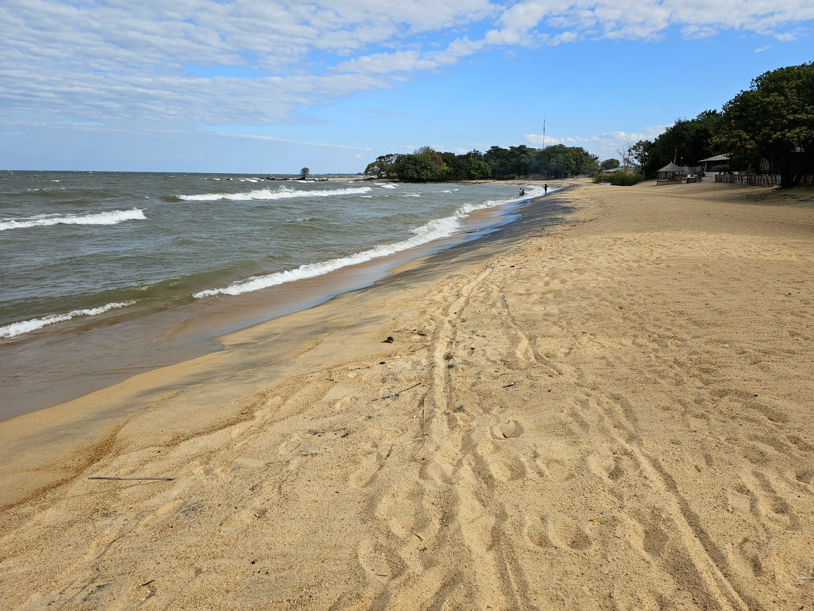
-

- 261. There were also quite a lot of charcoal sellers along the roadside in the 78 km today I guess there were more than 100. 1 bag was 60-70 Kwacha (£2).
-

- 262. When I got a catastrophic puncture and had to change the tyre Terrance, who was cycling past stopped to help.
-

- 263. Many of the charcoal makers lived in traditional mud huts near the road. It was very much a cottage industry but a prevalent one.
-

- 264. As the main road went through Zimba it widened out with market stalls and small shops lining each side of the road.
-

- 265. Even the side streets leading down to thr Floating Attic Guesthouse where busy with stalls. Zimba was a market town for the surrounding rural districts.
-

- 266. It was a joy to be back on the gravel roads. This one was just outside Zimba heading towards the villages of Chuundwe, Mankubu and eventually Kasikilis
-

- 267. After about 25 kilometres i reached the River Kaloma which was still just running.
-

- 268. There were plenty of homesteads each side of the road. They all had a new square brick house with a tin roof as it were a free government issue.
-

- 269. Often the water source or hand pump wasn’t near the homesteads and it was common to see women carrying water in buckets on their heads or transporting drums on ox carts
-

- 270. There were occasional hamlets of shops. Usually one would be a bottle store/pub with men sitting chatting. The other shops were ofter run by or had women at them but not the bottle shop.
-

- 271. All the homesteads had somewhere to store maize so rodents didn’t eat it. There were usually round and on stilts like these two – which were full of maize.
-

- 272. On the last 20 kilometres before Kasikilis the road became narrow and much more potholed and washboarded., but it remained a firm surface.
-

- 273. At Luyaba I fully expected to camp somewhere but found this small basic lodge for 150 Kwacha (£6). It had toilets in a separate rustic shed
-

- 274. Leaving Luyaba in the morning with the sun shining on the small collection of shops in the heart of the village.
-

- 275. One of the graneries at a homestead which was packed full of maize from this year’s harvest. The 3 small shelters are for chickens to roost in.
-

- 276. One on the many covered outdoor kitchen designs were the morning and evening meals are prepared and the family gather.
-

- 277. The steep section of road leading off the rolling plateau where Kabanga lay and heading down through the bush to Mapatitzya.
-

- 278. Mapatizya village with the traditional homesteads on the photo’s left and then the newer commercial street with shops.
-

- 279. The simple accommodation at the Deep Purple Lodge was adequate and had a hot water bucket shower in the yellow bathroom. The name is from amythyst rather than Rock and Roll.
-

- 280. The restaurant in Mapatizya. The pot on the left contained chunks of beef in a gravy and the one next to it salty green vegetables. The nshima was in a bucket.
-

- 281. The very tasty meat and vegetables were needed to make the bland nshima tasty.
-

- 282. From Mapatizya the road deteriorated and descended quite steeply in places for a good 5-6 km to reach the village of Siwaza.
-

- 283. The idyllic homestead, probably for and extended family on the steep descent from Mapatizya to Siwaza.
-

- 284. By the time I had descended even further to Siameja village the landscape had become very arid and baobab trees were becoming common.
-

- 285. Well after Siameja village and just before Muunku village I reached a large river bed which still had a few pools. I think it was called the Zhimu River.
-

- 286. Between Muunka and Siabaswi the road became quite sandy as it went over a arid sand strewn shallow ridge for 20 km.
-

- 287. The meal at Enedge’s restaurant with drumstick, some cabbage and the ubiquitous nshima.
-

- 288. Enedge’s restaurant had just a single chicken drumstick sitting in the plastic container and some sweet buns when I arrived.
-

- 289. My room and the bathroom and toilets at Enedge’s Lodge in Siabeswi. I was grateful for the accommodation otherwise I would have been in a tent somewhere.
-

- 290. The main cluster of shops beside the main road in Siabeswi. The lane with the welders quarter was on my right.
-

- 291. In the early morning people flocked onto the road to start the day some with enormous loads on their heads.
-

- 292. Where the gravel road from Siabaswi met the tarmac road near Maamba was a larger shop. Here the owner’s mother made up some nshima from maize flour on a charcoal stove.
-

- 293. The tarmac road out of Maamba was busy with people heading between hamlets. We all had ro dodge the occasional slow coal truck.
-

- 294. The Kenzinze and Zongwe Rivers met in a wide sandy valley. On each side water was used to irrigate a second harvest of corn.
-

- 295. Where the traffic had to slow down to negotiate the large pot holes younger women sold boiled maize to the almost stationary traffic and passers-by.
-

- 296. The avenue of baobab trees leading down to a cluster of shops and the load bottle store/pub near Sinazongwe.
-

- 297. On the sandy tracks through the dispersed village of Sinazongwe there were frequently cattle and goats on the road.
-

- 298. The tracks of Sinazongwe where also busy with people, from nurses returning from clinics and health posts to excited children.
-

- 299. My small chalet at Lake View Lodge. It was deceptively big with a attached bathroom at the back.
-

- 300. The view from Lake View Lodge looking across the lake which was about 20 km wide here to Zimbabwe on the other side.
-

- 301. The reception and dining area of the Lake View Lodge where I sat on the verandah all morning and wrote the blog for the last few days.
-

- 302. There was a slight beach below the lodge amongst boulders. In areas with much more reeds than this the Bilharzia snail can be found around Lake Kariba.
-

- 303. Despite warnings of crocodiles there were a few small dugouts and canoes on the lake fishing with nets. The fishermen knew where the crocodiles were likely to be.
-

- 304. Hollowing out a large log with an adze to make a dugout canoe to be used for fishing on Lake Kariba.
-

- 305. The road to Sinamalima was generally quite good with a few sandy patches. There was fields on each side and these ones were cotton.
-

- 306. Where a dry river bed crossed the road holes were dug in the bed to for a pool of water which was pumped up to the adjacent field to irrigate.
-

- 307. Just before Sinamalima I came across a hamlet of shops where I stopped for a drink and was surrounded by excited children.
-

- 308. After Sinamalima the homesteads became more traditional and slightly poorer as I headed east.
-

- 309. As I neared the Njongola River the rough gravel road quickly deteriorated into a track and then a footpath where rainy season torrents had rendered parts impassable in a 4X4.
-

- 310. The treacherous eroded edge of the track the poor young blind man fell down 3 metres and hit his head on the concrete pipe. He could not climb back out so I helped him.
-

- 311. My tent beside Minister’s house in his compound in the hamlet just before the Njongola River. I think Minister might have been the hamlet’s headman.
-

- 312. The three legged cooking pot on the three stone fireplace. It was around this everybody gathered and all the cooking was done.
-

- 313. One of Minister’s neighbours had a charming son who was very interested in the phone and camera on it.
-

- 314. In the morning I managed to get a picture of my hosts. Minister is in the middle with the red and yellow shirt and his daughters to the right. The others were close neighbours.
-

- 315. The concrete causeway over the Njongola River was partially destroyed. It would have been unparalleled after a moderate amount of rain. The ox team were pulling a heavy log.
-

- 316. The long steep footpath on the east side of the Njongola River. It was also impassable to 4X4 vehicles.
-

- 317. After the first hamlet on the north side of the Njongola River I should have gone down into the flat valley but by mistake did not see the junction and my preplanned route went to the right.
-

- 318. My preplanned route took me up through some horrendous, overgrown terrain where the old road was destroyed by torrents and abandoned. It took a while for me to work my mistake out.
-

- 319. After my descent through the bush I came across this gorgeous, traditional and remote hamlet with perhaps 10 households which was 4-5 km south of the gravel road on a footpath.
-

- 320. The gravel road from Siabbamba village to the T junction with the bigger road was about 30 km and passed a few villages. It was quite hilly.
-

- 321. As the road approached the larger gravel road it became very arid again with dusty bare hamlets and large baobab trees.
-

- 322. The Gwembe council guesthouse in Munyumbwe where I spent a rest day. It still worked but needed some maintenance.
-

- 323. These guys easily kept up with me for 2 km on their bike with no gears and no brakes. Zambians are strong and fit.
-

- 324. None of the villages today had electricity and everyone had to fetch water from a borehole in this arid landscape.
-

- 325. There were a few irrigated experiment areas where an Irish charity was trying drought resistant maize.
-

- 326. Some of the villages today were exceptionally arid and almost Sahel-like. There was no ground cover whatsoever.
-

- 327. A large field of harvested sugar cane. I think this feild with its sentinel baobab trees was too big for one family to plough, sow, tend and harvest and must have been communal.
-

- 328. There were many vegetable patches beside the dry stream beds where the vegetables were watered by bucket from holes dug in the sand. Note the animal exclusion fence.
-

- 329. My room in Changa was perfectly adequate for what I wanted. The toilet was a long drop in a separate shed.
-

- 330. On the northside of the road after leaving Changa heading east I passed below the Zambezi Escarpment.
-

- 331. Many of the graneries now seemed to be daubed with mud and some painted even. I could not work out whu this became more prevalent over the course of the last 10 days.
-

- 332. More and more of the houses had large overhangs on them and I assume it was to keep them cooler.
-

- 333. The was plenty of charcoal production, on a cottage industry scale around Changa and further east, to the detriment of the scrub.
-

- 334. Women seemed to do the lion’s share of the work in Tongo society, but were happier and more cheerful than the disenfranchised men.
-

- 335. Although there was little wildlife life on the ground birds seemed to survive. However eventually they has to be careful as there were always catapults about to help them into the cooking pot.
-

- 336. The village of Matavista was only reachable by bicycle after a 6-7 kilometre journey on paths through fields.
-

- 337. At the Machembere Lodge there was a great view across the 500 metre wide Zambezi to Zimbabwe. Apparently it was only a metre or two deep.
-

- 338. In the morning a herd of 7 adult elephants emerged out of the forest along the riverbank next to Machembere Lodge.
-

- 339. The elephants stood on a clear bit of land on the border of Machembere Lodge before the ventured in.
-

- 340. Some of the 7 elephants started breaking palm fronds off on Machembere Lodge lawn and devoured them.
-

- 341. One elephant came within 15 metres of where I sat on the verandah writing the blog as it pulled branches down right in front of me for half an hour.
-

- 342. The verandah on my chalet where I was writing when the elephant came within 15 metres to eat the lighter green leaves hanging down.
-

- 343. The inside of the chalet with the bathroom and storage room at the far end. It had a very high roof.
-

- 344. Some 10 km north of Chirundu I reached the Kafue River. It had a bream or tilapia farm on it near the bridge. I think it was Chinese owned.
-

- 345. The good people of Gota-Gota returning from church in their finest. I passed many churches this Sunday morning and most seemed to be singing gospel type hymns although I also passed a fire and brimstone sermon.
-

- 346. From Gota-Gota I headed north on a small, slow village road for about 20 km to meet the infamous D481 just before the start of the steep climb.
-

- 347. The extremely steep 350 metre climb up the Zambezi Escarpment on the D481 was loose, rough and very taxing to push a 70 kg bike up for 2 hours
-

- 348. It was a joy to meet Blyth and John near the top of the climb when I was exhausted. They had set off from Chongwe at 0200 in the morning with a 50 kg sack of maize each and hoped to get to Chirundu. We applauded each other.
-

- 349. At the top of the climb there was a very steep 250 meter descent down to a side valley, with the Mufundeshi stream at the bottom. Tomorrow’s 280 metre climb up the other side can be seen ahead.
-

- 350. At Mufundeshi stream I met Joe, his brother and their two wives. They were farming here and allowed me to camp in their compound.
-

- 351. They had been farming here for a couple of years and had dug a water source nearby. They lived in tents rather that mud huts and cooked and gathered under this shelter.
-

- 352. The climb up on the north side of Mufundeshi Stream was about 280 metres but although brutal was not as bad as yesterday’s climb.
-

- 353. At the top of the climb there was good views across the top of the Zambezi Escarpment to where the plateau started.
-

- 354. Just some 4-5 kilometres from the remote Mufundeshi Stream I started to reach the plateau and came across the first farms and a few abandoned exploratory mines. The road improved with every kilometre.
-

- 355. The top of the Zambezi Escarpment continued across wild remote hills to the east, but to the north it became gentler farmland.
-

- 356. Up on the plateau the farms looked less poor. Joe said it was because it rained more than the arid landscape I had been in for the last week.
-

- 357. The were all sorts of denominations in South Zambia, notably Pentecostal, Seventh Day Adventist and New Apostolic – which is pictured above.
-

- 358. The view from my rustic lodge over to Leopard Hill. Leopards used to inhabit the hill until the 1960’s when the population significantly increased.
-

- 359. The road from Katoba to Lwiimba was about 20 kilometres and very bumpy due to embedded stones
-

- 360. I passed about 6 depots with hundreds of sacks of corn at each. Apparently the government was buying the maize kernels at 350 kwacha per 50 kg sack.
-

- 361. Near Lwiimba I spotted a perfect mutual hut or rondavel. It this area the traditional was giving way to modern.
-

- 362. The plateau was now expansive and undulating and virtually all of it was potentially good farming but only for a crop a year without irrigation.
-

- 363. Chongwe market was in the centre of town and at least the size of a football fields. The vegetables section was the biggest but there was also, dried fish, metalwork and even various charcoals.
-

- 364. In the metalwork section there were large wheelbarrow with a car tyre as wheels, window and door frames and these various sized charcoal stoves.
-

- 365. The Great East Road, the T4, heading east out of Chongwe. This arterial road connects Lusaka with Chipata and then Malawi. Note the typical verge.
-

- 366. On one 2 kilometre stretch there were perhaps 20 eccentric and unique churches in addition to the more established ones.
-

- 367. Despite the road there was still many rural homesteads each side of it away from the towns
-

- 368. My lunch stop in Shingela where I had nshima (maize meal), spinach and goat, which is very much the staple.
-

- 369. The descent down the long hill onto the plain where the town of Rufunsa lay. This descent was exactly what I needed after the long day.
-

- 370. It was cold leaving Rufunsa in the early morning. Already by 0700 there were school children walking to school.
-

- 371. The homesteads were still very traditional between Rufunsa and Luangwa Bridge.
-

- 372. The homesteads were also in the forest sections on a couple of the larger ridges I had to cross .
-

- 373. All the way from Rufunsa to Luangwa Bridge the road was quite hilly and seldom flat. The verge was always quite dubious.
-

- 374. The village borehole and handpump was always a busy place. There must be tens of thousands of such pumps in Zambia enabling people to live where it was not possible before.
-

- 375. There was frequently charcoal for sale in 200 kwacha bags beside the road and this seemed one of the few ways farmers or villagers could get cash.
-

- 376. Looking across the Luangwa River from Luangwa Bridge Camp. It is one of the major rivers of Zambia and drains the entire east side of the country. On the far bank is Mozambique.
Section 04. North East Botswana
-

- 171. At many of the small villages along the road there were local cafes. It would nor be long before i was eating in them.
-

- 172. At last I saw some other cyclists after a month on the road. Marcus and Simon were doing the exact opposite to me and going from Dar es Salem to Swakopmund.
-

- 173. A slightly poorer than typical compound beside the toad wirh a round mud hut, a newer room house and a water rank all within a stockade.
-

- 174. After the veterinary fence I left the ranches of Ngamiland and entered a National Pak where there was no livestock and the grass could grow tall.
-

- 175. As dusk fell the elephants came out of the bust to wander along the road.. I saw 6 in all lurking behind trees. Thw all fanned their ears when they saw me and watched me pass.
-

- 176. My camp under the telecom mast in the fenced compound with gates. We closed the gates to keep the elephants out.
-

- 177. The large female was guarding the back left of the procession helping a matriarch bring up the rear.
-

- 178. I had already seen about 20 elephants that morning so expected to see even more now i was entering the National Park.
-

- 179. I got to these 4 large elephants and thought it would be foolhardy to squeeze past so spent 10 minutes observing them until a car arrive to escort me past
-

- 180. Up close the 4 elephants were quite daunting and very large.
-

- 181. As I was approaching the first zebra herd this large elephant suddenly burst out of the bush and crossed the road.
-

- 182. Waiting for a large herd of about 300 zebra to cross the road. There was another herd of 300 just beyond
-

- 183. Some of the zebra. They were not wary of cars and lorries but very nervous of me and bolted soon afterwards.
-

- 184. One of the streets in Phuduhudu village with their big trees and well kept compounds with traditional buildings and huts
-

- 185. Some of the happy kids in the village of Phuduhudu. There welcome gave me the confidence to go and ask others if I could stay in the village.
-

- 186. My tent on the verandah of the community hall, where the visiting fire fighters had said i could camp.
-

- 187. I saw a couple of giraffes on the south side of the road about 10 east of Phuduhudu.
-

- 188. About 20 km east of Phuduhudu i came across another herd of zebra with About 50 animals in total.
-

- 189. As I cycled east further into the Makgadigadi National Park the bush almost dissapeared and there was just scattered scrub rising out of the endless savannah grasses.
-

- 190. Just on the eastern edge of the Makgadikgadi National Park I saw a flock of about 40 ostriches.
-

- 191. On the outskirts of the large village of Gweta i saw this enormous Boabab tree which was about 35 metres high and the biggest Boabab i have seen.
-

- 192. The quirky but slightly chaotic and ramshackle Gweta lodge had a tiny rondavel type room for me with an outdoor bathroom behind the wall on the left.
-

- 193. There were lots of large baobab trees around Gweta, especially near a lodge called Planet Baobab.
-

- 194. One of the largest was right beside the lodge and must have been 7 metres in diameter. It was a behemoth.
-

- 195. The were lots of subsistence homesteads beside the smaller road near Gweta. Many have maize fields.
-

- 196. Half way between Gweta and Zoronga were huge salt pans which must now fill after a very wet rainy season. Perhaps once a decade in this climate era.
-

- 197. Between the salt pans on each side of the road was savannah grasslands which was being grazed by large mixed herds of cattle and horse
-

- 198. The neighbouring compound at Zoronga next to the absent policeman’s house where I was allowed to camp.
-

- 199. My tent next to the policeman’s house in Zoronga. He was away but told a neighbour I could camp there.
-

- 200. The road between Zoronga and Nata was usually fine but for 3-4 sections each of about kilometer the tarmac was destroyed and people preferred the verge
-

- 201. Near Zoronga the landscape was covered in a sparce forest with well cropped grass underneath. There were hamlets and homesteads hidden in these forests some 200 metres from the road.
-

- 202. There were many salt pans which had dried out but a few still had water like this one with livestock and flamingos.
-

- 203. Between the salt pans the landscape was open veldt with golden grasses flowing in the breezes
-

- 204. The bar and dining area at Eselbe Backpackers was the meeting place for younger travellers on independent overland trips.
-

- 205. One end of my room at Eselbe Backpackers in Nata with the semi outdoor bathroom.
-

- 206. On my very relaxing day off at Eselbe Backpackers in went for a short paddle on the Nata River having been assured thw were no crocodiles in the remnant of the river which had no flow in this dry season.
-

- 207. The large communal dining table and fire pit beyond it were the social hub of Rupert’s backpackers.
-

- 208. Some of the termite mounds on the flat open savannah with limited bush were 3 metres high.
-

- 209. The open savannah just north of Nata was initially open until the scrub started to appear.
-

- 210. My lunch stop at one of the small shacks by the veterinary fence which sold non perishable items only.
-

- 211. Just north of the Veterinery fence I started to see more wildlife animals like these zebras.
-

- 212. The first elephant of the day was grazing at the side of the road and was unperturbed by traffic. I had to have a 4×4 escort me past it.
-

- 213. The third elephant of the day was very wary of traffic and was about to cross in front of me when a 4×4 appeared and then it fled back into the bush.
-

- 214. My camp in the fenced compound 85 km north of Nata. The gate was open on arrival and I secured it with my bike lock once inside.
-

- 215. The elephants had previously pushed over some f the fence around the telecom mast compound, so now it was also protected by a ring of sharp rocks and spikes.
-

- 216. There were frequent elephant trails and tracks emerging out of the bush with fresh dung, but I did not see any all day.
-

- 217. A gentle reminder at all the parking lay byes on the road that wild animals were about. This sign looks like it was used by elephants as a scratching post.
-

- 218. I passed a few watering holes and even this small lake but did not see a single animal all day.
-

- 219. About 20 km south of Pandamatenga I passed a large cattle grid separating the wild bush from organized farming where these large fields of sorghum flourished.
-

- 220. The bar and dining area of A Touch of Africa Lodge was a relaxing place to have a day off physically recovering and catching up with the blog.
-

- 221. During the daytime a herd of about 20 impala wandered out of the bush to the vicinity of the cabins but did not go to the waterhole.
-

- 222. In the evening, just at sunset, some 6 large Roan Antelope came to drink at the Touch of Africa lodge waterhole
-

- 223. The pairie-like farming operations just to the north of Pandamatenga.
-

- 224. A field of sorghum just north of Pandamatenga was completely incongruous with the wild bush of the last few days.
-

- 225. A large Tawny Eagle perched on a tree beside the road looking for an opportunity to hunt or scavenge.
-

- 226. These zebra were the only game I saw all day on this 100 km stretch of road which is renowned for its wildlife.
-

- 227. In the distance i saw a lone elephant making its way across the savannah towards a waterhole or the scrub forest.
-

- 228. In Kasane there are warning signs for hippopotamus crossing the road as they make their way from the river to graze each night. They can go up to 7 km to graze before returning at dawn.
-

- 229. On the game drive in Chobe National Park the guide came across a very experienced pride of lions who had taken down a buffalo and feasted all night.
-

- 230. Not long after the lion’s we came across a small herd of giraffes who were grazing the treetops as the sun came up.
-

- 231. We came across a large breeding herd of buffalo which the guide thought had come across the river from Namibia.
-

- 232. We came across a second pride of lions who were feasting on an eland. This pride were not so experienced and contained many cubs, like these two playing.
-

- 233. There were many small herds of elephants scattered in the bush or drinking from the river
-

- 234. Looking across the southern channel of the Chobe River to the flat flood prone island of Sedudu.
-

- 235. This ekephant was nonchalantly eating the shrub just a few metres from the jeep
-

- 236. We saw plenty of more giraffes on the game drive in Chobe National Park.
-

- 237. As we were leaving the park we passed a large male Greater Kudu with its distinctive spiral horns .
-

- 238. On the Chobe River cruise in the late afternoon there were many crocodiles along the banks. This one was 3 metres.
-

- 239. We also passed by a few elephants in deeper water eating aquatic reeds. The two babies were excellent swimmers and were frequently submerged.
-

- 240. As the sun began to near the horizon the hippopotamus emerged from the river. Here is a large bull male.
-

- 241. There were quite a few older buffalo on Sedudu Island where they could graze without fear of attack by lions.
-

- 242. As usual there sun went down quickly and in a blaze of colour with returning from the Chole River Cruise on the small boat.
Section 03. North West Botswana
-

- 146. The track after setting off from Qangwa was packed hard and easy to ride on through the bush.
-

- 147. The hornbills have been present every day since I started but have got more prolific in the scrub savannah.
-

- 148. The very clumsy chameleon moved with juddering motions and very slowly
-

- 149. This sandy stretch was about 40 km from Nokaneng and was nearly 5 km long. It tested my patience.
-

- 150. My campsites by Nokaneng was in this clearing behind the bushes out of sight from the track
-

- 151. In the morning the cattle were released from the protective corrals and led into the bush to forage for the day.
-

- 152. Much of Nokaneng was compound s with the traditional round huts and perhaps a newer 2 room square house.
-

- 153. Many of the cattle posts were quite subsistence based like this but others were larger.
-

- 154. The 110 km from Nokaneng to Sehithwa was surprisingly good with big verges, some of which were being overrun with the huge thorned acacia scrub.
-

- 155. In Tsau I stopped for a drink and saw one of the traditional donkey carts which were common here.
-

- 156. A few of the cattle posts, or ranches, had men on horseback bring the cattle in as the day ended and dusk neared.
-

- 157. The spread out simple compounds and houses of Sehithwa covered a large area
-

- 158. The roadside cafe come bar in Toteng. It was the least rowdy of about 7 places in this mining village.
-

- 159. The road was flat and straight with a 1 metre wide tarmac verge and good for cycling. The grassy verges had a lot of foraging livestock on it.
-

- 160. One of the numerous smaller subsistence type farms with a simple 2 room house, a few round mud huts and a corral for the livestock at night.
-

- 161. Sofie, one of my guides for the day launching here Mokoro at Daunane village into the lagoons while a herd of hippopotamus bask on the other shore
-

- 162. The height of the lagoons varies throughout the year so much of the plant life is adapted. These lilies float on the surface.
-

- 163. On the walk we passed another lagoons with a herd of hippopotamus out of the water basking in the sun.
-

- 164. The herd of hippopotamus were content to stand on the shore with their short legs supporting their massive weight.
-

- 165. On the walk of about 8 km across the savannah we saw about 10 small herds of zebra
-

- 166. On one occasion we saw 4 giraffes scattered with a small herd of zebra.
-

- 167. Mantre, the guide, had such a keen eye and managed to spot so many animals, including this distant bull elephant, one of 2 we saw.
-

- 168. On the way back we went remarkably close to the herd of basking hippopotamus in the very vulnerable mokoro canoe. Mantre assured me it was safe and he spent his life amongst them.
-

- 169. My two guides for the day, Mantre and Sofie. They were both from the local village of Daunane and the lagoons were part of their community land.
-

- 170. One of the compounds at Duanane village. I side the outer fence was two round huts and these had a reed fence around them incorporating them into an inner sanctum.
Section 02. North East Namibia
-

- 111. Near Dornhugel farm i saw my first ostriches of the tour. They were grazing in a field.
-

- 112. At one of the redistributed farms on the D 2844 there was a.charcoal operation which was almost industrial. All the surrounding trees had been cut down.
-

- 113. As I passed the junction of the D2844 and D2845 i came across sprinkbok in the fields and huge flocks of guinea fowl on the road.
-

- 114. My campsite at Mooilaagte Farm. Just beyond the fence was a salt lick and a nightlight so I could watch Eland, wilderness and springbok come and fragrance in the early evening.
-

- 115. There was a large herd of springbok, perhaps 100 animals, which ran across the road a few times just ahead of me as i cycled along the D2844 shortly after setting off from Mooilaagte Farm.
-

- 116. I saw some zebra as i cycled through Mooilaagte Farm.
-

- 117. There was a herd of wildebeest on the southside of the D2844 near Mooilaagte Farm.
-

- 118. There were a few hills and some sandy terrain where the Gravel D2844 road neared the dried up Omatako River valley.
-

- 119. The shop at Rooidag was just the othersde of the veterinary fence. To the east was Africa proper and Bushman Land.
-

- 120. The !Kung Bushman campsite site 10 km east of Rooidag was relaxing simple and friendly.
-

- 121. My host, Simson, at the !kung campsite which was a Bushman camp. It was very quiet and relaxing. It was 10 km east of Rooidag.
-

- 122. My tent under the stars on the red sand of the !Kung campsite.
-

- 123. Ssimson making the family breakfast on the fire. I always see the kitchen outside rather than inside so far in Africa.
-

- 124. Looking back at the climb out of the Omatake dry river valley where I had o push up the sandy slope.
-

- 125. Mrs Chakwanda walking across her compound after pounding the maize for the evenings meal.
-

- 126. My tent in the shade of one of the distinctive square huts typical of the !Kung bushmen who migrated from strife in Angola in the Misty of history.
-

- 127. Chatting to Marten as the sun goes down and the temperate drops rapidly.
-

- 128. The donkey being chased down the road on the morning as if would not go onto the verge
-

- 129. I usually cycle a bit and then have a simple breakfast of granola and powdered milk at 1000 one i have a few kilometres under my belt.
-

- 130. Elephant dung from and elephant which had walked down the road for a kilometre in the past week.
-

- 131. The small shop at Perspeka almost halfway between Luhebu and Tsumkwe. I stopped here for curiosity and a chat.
-

- 132. The were a few small hamlets hidden in the bush just off the road between Perspeka and Tsumkwe. Whenever I passed the villagers they waved.
-

- 133. The hamlet of Apelpost about 15 km west of Tsumkwe seemed to have about 15 households and on corral into which all the sleep, goats and cattle went
-

- 134. The straight roads sometimes went for 10 km through the flat level scrubland, and I felt insignificant.
-

- 135. The reception area and dining room of the Tsumkwe Lodge was characterful.
-

- 136. The rustic cabins which over looked the parched “waterhole” to the left had a few goats grazing in it.
-

- 137. One of the 3 supermarkets in Tsumkwe. Most had large sacks of staples like maize porridge, rice, and a small selection of tins and soaps. Nothing was perishable
-

- 138. The hub of the small town was the petrol station. It was here local people gathered for lifts, pick ups filled up and bought drinks or crisps in the simple shop.
-

- 139. The Tsumkwe Lodge was a tranquil place to spend an afternoon once i had all my chores done
-

- 140. A Damara man and his Bushman brother-in-law en route to Tsumkwe on broken bikes to sell some wooden carvings of pangolins to the tourists.
-

- 141. I had been seeing more and more dung on the road in the last 10 km and this was proof they were about.
-

- 142. The good road continued all the way to the border post at Dobe.
-

- 143. After the border post and on the Botswana side the road was rougher and the gravel verges had been entirely encroached upon by the bush.
-

- 144. The compound I asked if I could sleep in at Qangwa. There were at least 100 such compounds in Qangwa.
-

- 145. My tent under a tree on the sandy soil in the compound at Qangwa.
Section 01. North West Namibia
-

- 026. At the beach by the old jetty at 0900 in the morning. The bike was very heavy and loaded with 5 days of food and 2 days of water. In all the panniers were perhaps around 45 kg.
-

- 027. On the northside of Swakopmund were large evaporation ponds where salt was produced and stored in huge piles.
-

- 028. As I cycled north on a perfect road I have the desert to the east with distant hills simmering in the haze.
-

- 029. On the road north I had the Atlantic Ocean to the west. Here cold currents enabled it to be very productive. There were huge flocks of cormorants, Cape Cormorants I think, here with over 100,000 birds.
-

- 030. Just south of Henties Bay was one of the many ship wrecks along this Skeleton Coast. This particular ship, The Zelia, was wrecked in 2008 and is still intact despite the pounding Atlantic Ocean.
-

- 032. Setting off on the good firm section of the D1918 from Henties Bay to Spitzkop
-

- 033. Continuing east across the Namib desert on the road D1918 towards Spitzkop through the barren Dorop National Park
-

- 034. An immensely hardy Pencil Bush some how manages to survive in the arid Namib Desert extracting moisture from fog.
-

- 035. My beautiful first camp in the Namib Desert just as the grasses started to cover the bare gravel further west.
-

- 036. Sunset in Africa is short and sweet with a blaze of colour in the dry season, which is always is in the Namib Desert.
-

- 037. Looking west from my first campsite with the moon rising over some outcrops on the D1918 road
-

- 038. One of millions of the Armoured Ground Crickets which started to litter the road and adjacent grassland as I approached Spitzkop.
-

- 039. The long straight road from Henties Bay to Spitzkop was mostly graded gravel but towards the end had some frustrating sandy sections where I had to push.
-

- 040. The Armoured Ground Crickets often spent the day on tussucks of grass. They were everywhere and it was difficult not to squash them on the road while cycling
-

- 041. The granite batholith of Spitzkop the most spectacular granite outcrops in the area.
-

- 042. Approaching Spitzkop with tired legs in the early evening on a better section of the smaller road
-

- 043. Sunset behind Spitzkop from my camp in the cafe courtyard.
-

- 044. Spitzkop in the midday haze rises steeply from the surrounding desert/savannah.
-

- 045. One of the local homesteads making a living by herding sheep or goats between Spitzkop and Usakos
-

- 046. The must have attire for cycling across the Namib Desert. Sun gloves to protect the back of your hands. Long light coloured trousers, a sun hoodie, cap, sunglasses and 100% sunblock for lips and nose.
-

- 047. Pushing the bike across some of the sandier sections of road between Spitzkop and the tarmac B2 road i was heading for.
-

- 048. This section of track between Spitzkop and the tarmac B2 had recently been graded with a road grader, which smoothed the bumps but left the ground softer.
-

- 049. The oasis of the Bahnhof hotel with its delightful courtyard, shade and pool where I spent 2 days writing the blog and shedding equipment.
-

- 050. The small mine with the Tourmaline bearing seam of Pegmatites (light beige) which, when molten, forced its way into the cracks of the granite rust brown) and cooled and solidified
-

- 051. The Tourmaline bearing seam of Pegmatites below amd the granite above. The Tourmaline forms in rare pockets in the Pegmatite where the cooling speed and mineral composition allow crystals to form.
-

- 052. Looking north from the mine over the Khan River valley where Usakos lay and beyond towards the Eringi Plateau.
-

- 053. Looking north west from the mine over the Khan River valley towards the plateau on the other side where Spitzkop and the other granite outcrops rose steeply at sunset.
-

- 054. The Rohloff Hub contains 14 gears in a sealed chamber. Unfortunately the seal behind the sprocket leaked most of the oil out
-

- 055. The mountain just south of Usakos which Cornelius and his descendents owned and mined
-

- 056. Jaco said it should be possible to cycle the 32 km to Karibib on the nearly constructed road and it was for virtually the whole way. By doing this I was totally unstressed by the traffic.
-

- 057. Karibib was quite spread out and a bit more industrial that Usakos and did not have Usakos’s charm.
-

- 058. My lodgings in Karibib were the Halfway Overnight Guesthouse. The room was lovely and the courtyard cool and quiet.
-

- 059. The egde of the township of Usab. Although not as prominent as the adjacent Karibib it has a bigger population.
-

- 060. One of many tree festooned with the nests of various weaver birds. In the background is the Erongo Massif.
-

- 061. The dried up sandy river bed of the Khan River. It would provide a migration route for animals.
-

- 062. Looking across the grass plains with its smattering of trees towards the arid, craggy Erongo Massif.
-

- 063. The exceptionally straight road across the undulating plains towards Omaruru. This might have been a legacy of colonial German engineering.
-

- 064. As I reached Omaruru the trees were quite large and there were many termite mounds.
-

- 065. A promising roadsign outside Omaruru. Although i looked i did not see any but did see a troup of baboons amble across the road
-

- 066. Looking west across the scrub forest across the well fenced private game farms
-

- 067. In many places today the roads were as straight as a Roman road and visible for 5 -10 km until the next rise.
-

- 068. There were enourmous expanses on the east side of the road too with the acacia scrub savannah seemingly endless
-

- 069. On the edge of Kalkfeld I came across 3-4 herds of goats. They grazed the road sides and returned to Kalkfeld in the evening.
-

- 070. The Kalkfeld Coffee Stop was marked on Google Maps. However it was much more. Owned by the highly articulate Udi, it also did simple accommodation and dinner. It was a great find.
-

- 071. My comfortable clean room at Udi’s HD everything I needed.
-

- 072. My extraordinary host, Udi ya-Nakamhela, once had his own current affairs show on national South African t television and was also a new anchor there.
-

- 073. A pair of Pale Chanting Goshawks in a tree beside the road. I quite a few of these birds today
-

- 074. Cycling along the M63 was a delight. There was hardly any traffic, it was well graded and the temperate was perfect. These C roads are the best for cyclists.
-

- 075. My tent beside the barn at Ekungi Farm. There was a superb toilet block with a hot shower beside the barn
-

- 076. The view across the farmland towards one of the knolls dotted about on the savannah here.
-

- 077. African Sunrises and Sunsets are always glorious. This one soon banished the cold.
-

- 078. Some of the cattle on Gunter Kahl’s farm. They were cross breed but with a strong strain of Hereford running through them.
-

- 079. The beautiful gravel road across the wide open expanses between Ekundi farm and Outjo town
-

- 080. The were a few antelope spieces beside the road. I think this was a steenbok. It was a very fast sprinter.
-

- 081. There were a few farms owner by ethnic Namibians along the road. Thir cattle were more the local breeds.
-

- 082. The dried up Erundu River showed signs that a torrent had swept down here in the last months.
-

- 083. There were many sandgrouse in the areas beside the road. The Double Banded Sandgrouse was sitting on the road.
-

- 084. I rodent my bike right into the cafe at the Farmhouse in Outjo to a warm welcome. They had a room so I checked in.
-

- 085. The vast expanses of the countryside after leaving Outjo heading towards Otavi
-

- 086. Looking onto the endless savannah with its bigger trees and grassland.
-

- 087. The gravel road in this section between Outjo and Otavi sometimes did not turn a corner for 25 km
-

- 088. In the afternoon it got very hot but the sun hoodie protected me from the hot sun and reflected a lot of the heat.
-

- 089. Uib farm where I tentatively asked if I could camp nearby and was met by an avalanche of the most generous Afrikarneer hospitality.
-

- 090. The Lourie or Go-Away Bird frequented the trees at Uib farm in the morning to drink from the pond. It is known for its warning sounds which also alert game predators are about
-

- 091. Uib farm has been in the Coetzee family for 4 generations and is an oasis in the arid savannah.
-

- 092. The gravel road from Uib farm to Otavi was exceptionally straight and flat. There were farms all the way here mostly run by relocated Damara and Ovambo and it seemed many struggled.
-

- 093. I frequently saw families of mongoose along the road. Usually they fled into the bush before I could photograph them.
-

- 094. There only seemed to be one place to stay in Otavi and that was in a lush guesthouse in an otherwise dusty town.
-

- 095. The lovely cycle up the D2820 district road was through farmland and bush scrub.
-

- 096. There were plenty of cattle grazing in the farms beside the road for the first 20 km of the cycle today.
-

- 097. Half way along the road wasca watering hole where I saw a family of warthog
-

- 098. At the same watering hole as the warthog was a largevherd of Oryx or Gemsbok which i watched for a good half hour
-

- 099. Pne of the huge Brahman Bulls on Omatjete Farm which was both cattle ranch and game reserve
-

- 100. Just beyond the Omatjete farmhouse I saw an large Kudu sheltering under a tree.
-

- 101. There were plenty of impala in pairs along the road side
-

- 102. I also a large herd of at least 50 impala near a farm to the east of Omatjete farm. They were being watched by a group of baboons.
-

- 103. The red road, the D2820, cut a swathe across the savannah between Otavi and Kombat and it was a joy to cycle.
-

- 104. The huge empty bar and braai area under the thatched roof at the Kombat Lodge Inn. The rooms were similar style but much smaller.
-

- 105. The green irrigated fields of Nehlen farm by Kombat were used usual in Namibia.
-

- 106. One of the two earthen dams and watering holes on the east side of Kombat. The second had a large group of baboons.
-

- 107. The small terrapin which usually lives in the muddy ponds in the wet season and hunkers down in holes in the dry season.
-

- 108. The gravel road cut through a pass in the dense forest clad ridge. The forest was full of birdsong.
-

- 109. Looking across the large open fertile valley where the Hoba Meteorite was. The extensive fields were full of maize.
-

- 110. The iconic Umbrella thorn tree Acacia tortilla, was frequent in the fields, savannah and beside the road. It had terrible thorns.
00. Trans Africa Cycle. Preparation
-

- 000. The most obvious route to cross Africa taking while trying to keep quite rural and avoiding areas of political instability
-

- 001. The first section is the 1300 km across northern Namibia
-

- 002. The second section is the 1300 km across northern Botswana
-

- 003. The third section is the 1500 km across southern Zambia
-

- 004. The fourth section is the 800 km up the west side of Lake Malawi
-

- 005. The fifth section is the 1100 km across central Tanzania
-

- 008. The prototype wooden cart on its first outing in the soft sand of the beach with a 50kg payload. However the wheels were to thin and the pulling bars too low on the cart so the angle was excessively steep.
-

- 010. The actual cart I will be using at the end of the first day of welding. The wheels will be fitted on a bracket yet to be welded onto the horizontal bars.
-

- 011. The very talented engineer, Thomas Boileau, who helped me design the cart and did all the welding on in to put it together.
-

- 012. The finished cart with the collapsible plywood insert. In all the cart is about 120 ltres but can off course take lighter materials, like foam sleeping pads on top. The length of the pulling bars can be extended slightly
-

- 014. In the bottom of the cart is space for 20 litres of water which should last me 4 days or so. It will help keep the centre of gravity low
-

- 015. My fist aid kit alone weighd 2.5 kg and is quite comprehensive with 14 tablet types, insect erepellant and sun protection and a sterile needle kit. A full list is on the blog.
-

- 016. The short overnight trip with full paniers in the Highlands to see if I was happy cycling. Here at the old Reservoir between Dall and Innerwick
-

- 017. Andy and Rory with the finished bike which they put together with the help of Dylan. As I was quite ignorant about bike construction I left them to choose the components and put it together which they did in less than 2 weeks from scratch.
-

- 018. The bike out on it maiden voyage round Arthur’s Seat in Edinburgh. The 14 gears were in the rear Rohloff hub were perfectly matched to the front crankset and would give me plently of lower gears for carrying weight up hill. The bike with with all the added accessories is 21 kilos.
-

- 019. The bike with all the loaded paniers. In all the 6 containers weighed 29 kilos with all the equipment with about 33% on the front and 66% on the back. I addition to that I have to carry 3-4 litres of water, a litre of kerosene, a thermos flask for cooking beans during the days cycle and perhaps 3-4 kilos of food for a few days. So nearly 40 kg in all.
-

- 020. The repair and maintainence kit should have enough to keep abreast of simple reapirs on the bike, stove, tent and sleeping matteress
-

- 020. The Christuskirche is the historical German church from 1910 built as a peace monument to mark the end of the war between the Germans and the indiginous Herero and Nama. It is Evangelical Lutheran.
-

- 021. The Tinten Palast was the original German colonian administration built in 1913 with Herero and Nama slaves. It is now the seat of both houses of the Namibian government
-

- 023. One of the typically old German colonial buildings in Swakopmund. This charming town is popular with Namibian and foreign tourists.
-

- 024. The historical Hotel Prinzessin Rupprecht is quirky but full of charm. The profits from the hotel go into the attached old folks home
-

- 025. Swakopmund had a large landscaped area along the beach front, which added to its charm.