Main Alpine Divide. Section 13. Vanoise Alps
February 9, 2022

Day 86. Bellentre to Refuge d’Entre le Lac. 21 Km. 8.5 Hrs. 1750m up. 400m down. I was bit unsure of todays route and thought it best to leave early incase there was hiccups en route. In addition to that we also had to climb 1750 metres and that alone would account for 4-5 hour. so I set the alarm for 0530. By the time we had finished breakfast and packed it was already 0630 and completely light. We walked down the village of Bellentre to get bread for our lunch. However the shop did not open at 0700 on a Monday as we had thought. In fact it did not open at all on a Monday so we would have to get lunch elsewhere. We left the village, crossed the main road, and headed down a smaller road across a bridge over the clear Isere river to the south side. Here there was a small track up through the hazel woods.

570. Looking north over the roof tops of Montchavin to the town of Bourg-St Maurice in the arterial Tarentaise Valley. Further up the valley is the Col de Petit Saint-Bernard Pass and Italy.
The route followed this track making frequent shortcuts across the hairpin bends and climbing without respite for a good hour. It was quite a nice climb in the deciduous forest but a bit confusing on occasion and I am glad I had the GPS route to follow. On and on we climbed in the cool dry morning with just the odd cloud here and there. Suddenly the woods thinned and we reached a road on the other side of which was a mechanics garage on the edge of Montchavin. We wandered up through the lower half of the large village and popped out of an alleyway to find ourselves on the main street. There were quite a few shops and everything looked very quaint and well ordered. Montchavin was not an honest farming community, but one which seemed to live on tourism, especially winter tourism. There were a few modest ski lifts radiating up the hill from the town and these must bring in enough winter skiers to warrant the newer chalets and apartments which reduced the village’s charm. We stopped at the baker for bread and the small supermarket for tomatoes to complete our shopping list for lunch as we already had cheese. Across the large Tarentaise Valley I could see the lovely authentic farming villages of Valezan and Les Chapelles which were still very traditional. I could also see up the valley towards Bourg-St Maurice and the road to the Petit Saint Bernard Pass on the Italian border.

571. Looking south from the edge of the landslide area to the south of Montchavin over the villages of Piesey and Nancroix in the Ponturin valley where we want to be.
We continued up through the rest of the village beside a ski piste and then entered the pine forests again on a track high above the Ponturin stream in the valley far below to the east, where the villages of Piessey and Nancroix were visible in their meadows on the valley floor. After a few kilometres the path forked with a branch going up through the forest to high alp hamlets. Our path continued to contour across the steepening hillside with the expectation it would traverse down the valley side to the stream. However suddenly the grassy track disappeared and there was just a large gash in the mountain side 100 metres wide and 500 metres high where a landslide had obliterated everything. It was too late to turn back so we waded through the undergrowth above the landslide to try and get to the path on the other side. After a laborious five minutes forcing a way through tall raspberry canes and willow herbs, now covered in fluffy seed heads, we emerged on the track on the south side of the landslide. There was a path here which forked down through the forest from the track. The track soon came to a dead end in the forest. It was the path we wanted not the track but it looked unused, except by wild animals. There was absolutely no sign humans went this way and it was covered in fir cones and fallen twigs. It did not bode well and I suspected there was another landslide further on to isolate this section of path. We hesitated to follow it but then considered the alternative, and it made sense to try it at least. I went on ahead to see if there were any difficulties while Fiona followed on the tricky terrain at her own speed. There were some more difficult and steep sections for the next kilometre but nothing impassable and then I could see it eased off. I returned to give Fiona the good news and then we proceeded together to reach a track in the valley beside the stream. At the track there was a notice warning walkers coming the other way of the difficulties further up, but I saw none earlier. We followed the track up to the hamlet of Moulin where there was a bench and information board. It was a perfect place for our lunch of bread, cheese and tomatoes. On the information board we noticed that the old route for the GR5 from Bellentre to Montchavin to Moulin, the route we went, was now abandoned and the new route went from Bellentre to Landry then Moulin. After our adventurous detour we set off up the valley.

572. The charming bohemian hamlet of Les Lanches where there were a couple of artisanal places to sleep and a donkey sanctuary.
It was a beautiful valley of small hamlets in open meadows separated by hazel and rowan woods with some firs. The route was mostly on grassy tracks through these woods climbing gently past Nancroix, the largest of the hamlets and then past an old lead mine whose buildings were either now a museum or derelict. After a short hour we reached the last hamlet of Les Lanches. It was a gorgeous collection of bohemian, artisanal, small farmhouses and buildings all in working shape but not too over restored. There were 2 small homely Gites or B&B’s here which would have been very homely and quite cheap in rustic characterful houses covered in window boxes and old farming implements. A few of the houses still looked like small pastoral farms keeping some young bullocks. There was also a small donkey sanctuary here with 20 donkeys in a field. I think it was possible to hire them to take children on a small ride on colour coded paths in the valley. We crossed the main valley road here and went through Les Lanches on the small gravel road which ran through it crossing over an old wooden bridge to the east side of the dry stream bed. From here we went up through extensive meadows on the valley floor with just a few old stone houses scattered here and there. They looked like old summer alp chalets and all the shutters were closed. We then crossed the dry streambed to the west side again to reach a large car park at the end of the public valley road where there was a small Vanoise National Park Visitor Centre.

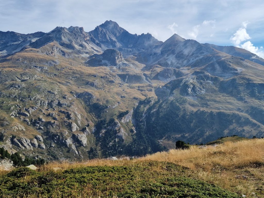
573. Looking up the Ponturin Valley above the delightful hamlet to Les Lanches to the upper meadows at the road end. The route goes up the valley and veers to the right round the corner.

574. Looking NW down the Ponturin Valley from the platform just as were leave the upper pastoral valley and enter the alpine zone
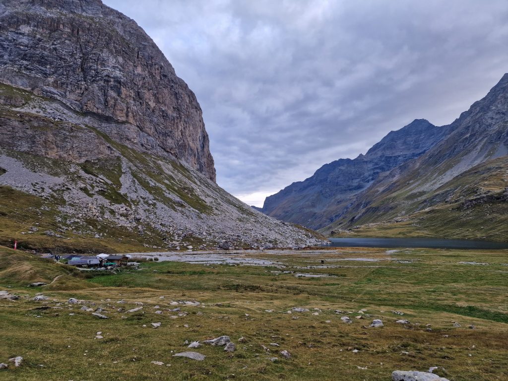
Once we passed the Visitor Centre the route became much less pastoral and more apine. It climbed for a few hundred metres through the higher woods which were largely rowan. They were now covered in berries but all the leaves were withering, possibly because of the drought although the berries were plump and juicy. There was a small viewing platform with a great view down the valley to the meadows we had just left. After the platform we passed a few magnificent wispy waterfalls bringing meltwater down from the small glaciers on the east side high above. The valley we were going up then levelled off after an old terminal moraine where there was a small shepherd’s hut called Chalet de Rose, 2020m. There was a small spring here with delicious sweet clearwater. Once we climbed over the moraine pile we reached a promised land. The valley sides rose up to high peaks with a scattering of snow fields and glaciers but the valley floor was a vast flat meadow with a clear stream meandering across it. Fish were rising in the stream and you could see their shadows on the beige gravel on the stream bed. It was a quenching sight on the hot day. The path was still a bit rocky but it was a delight to wander beside this long lush meadow. On the far side was a cluster of chalet buildings, which were once probably a dairy but I think now they were just maintained, but not used. After 2 kilometres this meadow ended in a small rise with a gentle cascade splashing down it. It was like a magazine advert for the Alps. At the top of this rise we reached another shallow basin with a deep blue lake, Lac de Plagne, nestled in the bottom of it. Round the perimeter of the lake was clear water and beige shallows before the deep blue. at the end of the lake was our home for the night, Refuge d’Entre-de-Lac, 2160m.
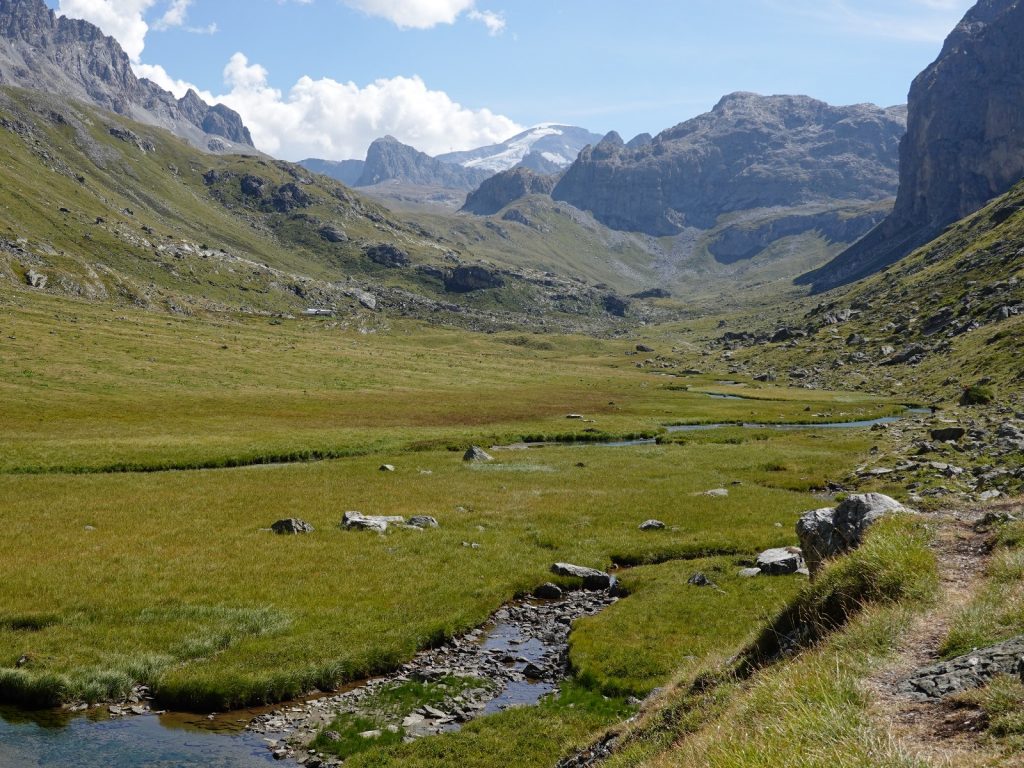
575. Looking up the upper Ponturin valley across the pastures to the south where the Lac du Plagne lake and the Refuge d’Entre le Lac lie
The refuge looked a bit ramshackle initially with various buildings, awnings and a yurt. However, the entrance was eccentric and the welcome very warm. We were allocated a small room off the main dormitory. This dormitory was in the main building which was an old cow barn some 40 metres long and 8 wide with a curved roof and immensely thick stone walls. It was like a vaulted dungeon with a door at each end. There were perhaps 10 sets of bunks on each side in the main dormitory but it did not feel cramped. I had seen few of these restored cow barns in this trip so it was exciting to be sleeping in one. The host was very knowledgeable about the area and the Tarentaise Valley in general. He raised an eyebrow with our route choice up the old GR5 before the landslide essentially destroyed it. We had a look around at the various buildings including the large yurt with 10 beds and then I found a place to write while Fiona went off and stalked a couple of Ibex who were grazing in the pasture nearby.

576. The Lac du Plagne lake in the upper Ponturin valley was an Idylic spot. Just beyond the far end of the lake is the Refuge d’Entre le Lac.
Just before dinner the hut host, who was quite a character, came out with a pail to milk his two brown cows. These were the same breed as all the cows we had passed since Mont Blanc and I now found out the breed was a Tarent or Tarentaise after the valley. The milk he got would be for tomorrow’s breakfast. At dinner we sat under one of the awnings which had 6 large tables. Only 3 were used for the 20 odd guests. We were sat at one with Remy and Niels, a French/Belgium team doing the GR5. They had met at the start and were hiking together. Remy was 50 ish and Niels 20 ish but both spoke great English and were very likeable. Remy was an Airbus pilot and very worldly wise. It was good fortune to meet them as I am sure our paths will cross again as we are both doing the same route for the next 3 weeks. There was also a very nice German lady and a shy Frenchman who said nothing at all. The meal was one of the best of the trip with a great French onion soup and cheese, A large omelette and ratatouille for me and roast chicken for the others, and a milk pudding for dessert from the two cow’s morning milk. It was a very sociable meal time. Just after darkness fell at just 2030. I retired to write while the others kept chatting with gusto, competing with the table of lively French medical students. By 2100 everyone started to go to bed. Remy and Niels both had tents and Fiona and I went off to the old vaulted barn to the small room off the main dormitory. I noticed a slight chill in the air now as the warmth of high summer was drawing to a close. The refuge was turning out to be one of the most characterful and sociable of them all.
Day 87. Refuge d’Entre le Lac to Refuge Entre Deux Eaux. 25 Km. 8.5 Hrs. 1250m up. 1280m down. The alarm went at 0630 as usual. It was a beautiful morning but the forecast was for rain and thunder in the late afternoon/early evening and we had an estimated 9 hours to walk. We were ready and packed by 0700 when we were unleashed to start breakfast. There was only us, Remy and Niels, and we had the leftover curd from yesterday and then lovely granola, fresh milk from the hosts cows, homemade bread and jams. It was a great breakfast to top off the lovely stay at this friendly and characterful refuge. By the time we left at 0800 it had already started to cloud over and virtually the whole sky had a thin layer of cloud over it.
577. Looking back to the Refuge d’Entre le Lac and the Lac du Plagne lake as we start the climb up to Col du Palet, 2652m.
We walked up the slope to the south of the refuge and the lake to gain the official path of the GR5 at the top of the climb where the ibex had been grazing yesterday. They were nowhere to be seen but in their place the hillside was alive with marmots. There were a few old plump grandees keeping sentry watch while a host of smaller ones from this year’s brood scurried round eating grass. For them the race was on to put on enough fat before the snows forced them into their burrows for the 6-7 month winter hibernation. One grandee was very obliging with photographs and allowed me to come within a few metres. We were in the Vanoise National Park now so I think they had been protected for many generations and their confidence with humans was ingrained in their DNA.

578. An obliging older marmot keeping sentry watch while the smaller marmots try to put on weight for the up coming winter’s hibernation.
A bit above the marmots the path reached the calm Lac de Grattelau, which lay in a bowl surrounded by jagged peaks. Around the fringe of the lake was a mantle of bog cotton in full fluff. Although there was water flowing out of the lake it must have soon disappeared under boulders because the pasture below it and adjacent to it were dry and the farmer had turned the water troughs upside down for the winter. Indeed the shortage of water became apparent when we climbed the short brown grass slope above the lake to the Refuge du Col du Palet. It was a splendid looking cabin, I think run by the Vanoise National Park authority, but it was already closed for the season as it had run out of water and its spring had dried up. Just above this cabin, in a brown boulderfield left by a recently departed glacier was the Col du Palet, 2652m, and the end of our 500 metre climb.
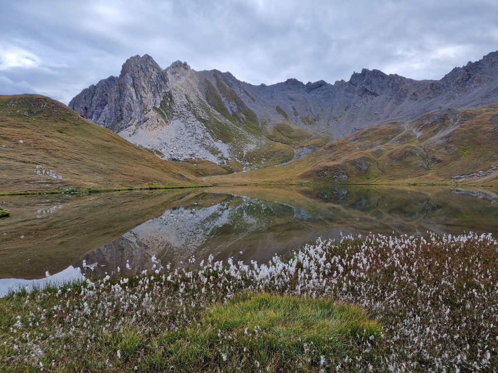
579. Looking across the Lac du Gratteleu fringed with bog cotton. The lake lies just under the Refuge du Col du Palet which was closed due to lack of water.
On the south and east side of the pass we entered a high alpine rocky environment with little grass but significant scars from the ski industry. There were lifts and access roads all over the mountainside and it looked like the pistes had been smoothed off by bulldozers over the last decades. This was the ski area of Tignes, a popular winter resort for skiers. The worst infringement was on the far side of the valley where I could see ugly pylons supporting a gondola right up the noble mountain of La Grande Motte. We walked down the hillside on a limestone type rock with more and more grass appearing as we descended. Marmots were plentiful here too and we passed at least 100. In a few months they would be hibernating in their burrows while skiers carved down the slopes just above them. I knew Tignes was an ugly development with a few high rise hotels around the once pristine lake of Lac de Tignes, but nothing could have prepared me for the ghastly eyesore which appeared as we rounded a small spur. Here in an alpine environment, well above the treeline was a lake and around the lake were tower blocks of hotels. It was like the dormitory suburbs for an industrial Soviet city. There must have been accommodation here for tens of thousands of gluhwein swilling skiers in fashionable headbands. All my criticisms of Austrian ski resorts (with the exception of the Stubai) should really pale to what I could write about Tignes. Indeed in retrospect some charmless development like Obertauern or Kals, which I found so distasteful earlier in the trip, could now almost be pleasant compared to Tignes. It looked like an artist’s impression of a futuristic city on Mars. I could console myself with the thought that the greedy developers of the Tarentaise Valley had sacrificed this corner of Savoie so the rest of the Alps could remain untouched. However, I knew this was not true and there were dozens of other developments all over the Alps. Surely none could even come close to matching Tignes for its culturally bankrupt mass tourism. We descended to the outskirts of the eyesore, which was still growing like a cancer in this alpine valley, and then skirted round its dormant hotels, restaurants, bars and discos and climbed out of the valley up the slopes on the south side trying not to look back.

580. The magnificent mountain of La Grande Motte, 3653m, was on the periphery of the Tignes ski area. It had a funicular railway in a tunnel up it and then a gondola at the end of the railway which went to the summit.
We climbed for a good hour passing downhill cycle paths for mountain bikers, until we found a spot beside a mobile dairy to have lunch. The smell of manure and the clunk of the cow bells soon restored my spirits after Tignes. After lunch the weather cleared briefly and we hoped the forecasters had got it wrong as the clouds vanished and bly sky appeared everywhere. It was a long but gentle climb from here up the valley through vast stone fields across the barren valley floor until we got to Col de la Leisse, 2761m. It was the top of our second climb of the day and from here it was all down hill for the next 12 kilometres. To the west of the Col the mountain, La Grande Motte, 3653m, dominated everything. Large glaciers with some small crevasses flowed down its eastern flanks and there was even some new snow on the summit ridges. However, the tentacles of Tignes ski development even reached these glaciated slopes with a funicular railway and then a gondola, even though it was in the Natural Reserve de Tignes and Vanoise National Park.
As we descended down the SW side of the pass into the Vallon de la Leisse we entered a moonscape of glacial debris from many recently departed glaciers, and a few in their final decade. The whole valley was strewn with moraine and there was no vegetation anywhere other than a few hardy coloniser plants. In 50 years all this might be arid meadows but for now it was just stones. Further down there was a shallow lake which was filling up with silt and stones brought down by downpours. There was a lake marked on the map at Plan des Nettes but when we got there it had vanished leaving just a horizontal line where the shore once was. We went round the north side of the dry lake to where the outlet had once been but it looked like a catastrophic event had broken through the rock and moraine barrier and the force of the empting lake had removed the 5 metre high natural dam and swept it downstream. Just below Plan des Nettes was a small prow and the Refuge de la Leisse sat on it.

581. Heading down the Vallon de la Leisee valley between Refuge de la Liesee and Refuge Entre Deux Eaux. The enourmous scree slopes are on the south side of La Grande Casse, 3855m, the highest mountain the Vanoise
The Refuge was three cabins and did not look that homely. The all female staff were not that welcoming and could not serve us for ages as they were in a “meeting”. Remy and Niels were here and with the forecast they decided to stay in a dormitory rather than camp in a thunderstorm. We eventually had a slice of brownie each and then continued down after saying goodbye to the other two who I hope we see again. It was still 6 kilometres to go but I could see the going was quite easy as the path was gentle and went across alpine grassland. We dropped down to a small bridge over the infant stream and then went down its south side as the stream grew quickly harvesting water from a number of springs emerging from under the moraine. On the north side of the Valley now was the La Grande Casse, 3855m, the highest mountain in the Vanoise. It rose very steeply from the stream for 1500 metres up to a crenellated crest which was attracting mist. Glaciers clung to its high ramparts but occasionally they shed ice and snow in the winter and this cascaded down gullies in large avalanches bringing stones with it leaving them on some of the biggest screes I have ever seen. The whole lower flank of the mountain was a skirt of scree which plunged into the stream. In many places the packed snow from avalanches still spanned the stream with a tunnel underneath for the stream and hundreds of tonnes of scree on top of the snow bridges.
The weather finally broke as we turned south where the Rouseau de la Vanoise stream cascaded down bare rock steps from the valley to the west. We just got our jackets and overtrousers on in time before the deluge started. It did not last long but it was intense. We went down the path to where 2 cattle dogs were rounding up the milk cows and driving them down the path on the east of the stream. There were about 20 cows and they were taking their time despite the frantic dogs and whistles from the farmer who was getting soaked in his casual jacket. We passed the cows as they went off down to the portable milking unit on a large trailer and then started a gentle ascent to the refuge. By now the rain had totally stopped and the returning sun was heating the ground causing steam. Behind us was a great view to the La Grande Casse and in front was the very nice refuge above a hamlet of alm houses.

582. Looking back to La Grande Casse, 3855m, just after the half hour rain shower had cleared. In the bottom right are cows being driven down for the evening milking
From the outside the refuge looked like a very good restoration of an old summer dairy and house. Inside it was warm and homely and very welcoming. Amazingly we were the only guests which surprised me as Refuge de la Leisse was full and it was nothing like this one for charm and comfort. We got two beds in a dormitory with 12 beds but it mattered not as we were the only ones. We arrived quite late at 1700 so by the time we went upstairs dinner was only an hour away. The host lit the fire and we sat in front of it feeling its warmth while outside the thunderstorm had arrived and it was pouring. It was extremely satisfying to be sat in front of the fire while the thunder roared outside and rain poured down the large slabs on the roof. Dinner was very good and Fiona’s beef stew in a red wine sauce was sensational apparently. At the end of the meal we were both full. I then wrote while Fiona made some sketches before going to bed early. I was finished by 2130 and the rain was still falling. It was a fantastic refuge again.

583. The charming and well restored Refuge d’Entre Deux Eaux was once an old summer alm and dairy. In the background is La Grande Casse.
Day 88. Refuge Entre Deux Eaux to Refuge de Plan Sec. 27 Km. 9.5 Hrs. 1480m up. 1300m down.

584. Looking SW from the Refuge d’Entre Deux Eaux in the early morning with the sunrise illuminating La Dent Parrachee, 3639m.
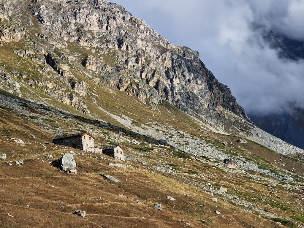
When we woke there was a stunning sunrise which illuminated the mountain of La Dent Parrachee, 3697m. It was the highest point of the southern massif in the Vanoise. We had to walk round the base of this mountain today to the SW side of it, where the Refuge de Pan Sec sat on a hillside above two dammed lakes. The breakfast was quite poor with no cereal and not a huge pile of bread. As usual we left at around 0800 and walked down to the Rochure stream on a damp track, as it had rained in the night, and crossed it on a solid bridge. Here at the junction of the two streams, the Leisee and the Rochure were a few clusters of alms houses and dairies. There was also a track here which came up over the mountainous plateau to the south all the way from Termignon. This well maintained track served quite a few dairies and summer farms and was the way the milk went out. I think there was also a bus from the track end here all the way to Termignon. A few of the stone alm houses had collapsed. Water ingress had rotted the roof beams which soon snapped under the huge weight of the stone slabs on the roofs. However, many of the alm houses were still in good condition and a few had been recently restored. We crossed to the west side of the stream which disappeared down a gorge which looked very inhospitable and steep. Its difficult topography was the reason the track had to come over the plateau to the east of the gorge.

585. One of the restored alm houses at the confluence of the Liesee and Rocheure streams where there was a cluster of such alms.
586. The alm house of La Para was built with stone walls under a heavy stone slab roof. I think this alm was used for sheep or goats rather than cows
We zig-zagged up the mountainside towards the southern massif of the Vanoise passing an all stone two storey alm, called La Para, which looked like a small citadel house from Dolpo or Tibet, except it had stone slabs on the roofs. After an hour’s climb we finally gained the crest of a spur above a line on impenetrable crags below us. We headed west for a kilometre with great views unfolding before us over the complex of glaciers called Glacier de la Vanoise. At one point we stopped and took some photos then heard the chink of sheep bells behind us. We turned around to see about 20 of them come over the crest of a knoll behind us and then walk quickly down the hill towards us. Another 100 soon appeared and then another 500 behind them. It was like a waterfall of maggots. They were surprisingly fast as they raced each other to the most succulent tufts of grass and moving much faster than we could walk. I was wary of the guardian dogs or Pastou who would be accompanying them and might see us as a threat but then a shepherd appeared and I knew he would pacify the dogs with a single whistle. Further west two small tarns appeared below us with the mountains and glaciers reflected in their calm waters, which were just occasionally broken by a small rising fish. It was an absolutely stunning view and Fiona went ahead so I could get some photos of her beside the tarns to give it a sense of scale.

587. The idyllic tarn with the Glaciers de la Vanoise in the background. For scale Fiona is walking on the path to the bottom left of the tarn.
After the idyllic tarns the route left the more pastoral landscape and crossed the settled moraine which the glaciers must have deposited here centuries ago. This moraine had settled and stabilised and much of it was covered with turf and patches of the yellow saxifrage, Saxifraga aizoides, especially where the slightly silty stream came down from the large glacier which covered the icy summit of Dome des Sonnailles, 3361m. After this torrent, which we crossed on a wooden log bridge, we climbed slightly across more settled glacial debris for another easy half hour to reach a balcony over the deep gorge far below where the two streams on each side of last night’s refuge were grinding their course ever deeper. Mist welled up from the gorge as it funnelled moist air up which was now condenscing around us. The mist came and went but it made the rocky path a bit greasy and our tempo slowed a bit as we had to be more cautious. In between a condensed obscurity we saw a female ibex slowly clambouring on the steep grassy slopes just above us. I looked for more but did not see any which surprised me as females often group together.

588. The female ibex was alone on the small crags just to the north of Refuge de l’Arpont. Female ibex are usually in groups
The air coming up the gorge must have dried slightly now as the mist became more sporadic and then disappeared altogether. It revealed a pastoral bowl with a cluster of old alm buildings. Most were in disrepair with their heavy stone roofs collapsing and some walls even toppling over. Waterfalls cascaded down steep slabs into this bowl. High up above the waterfalls was another large flock of sheep grazing among the outcrops. Just in front of us however was the refuge. It was originally a collection of alm houses which had been resorted but since I was last here 10 years ago a large modern extension has been built which was somewhat in keeping with the other buildings and then environs but with a large flat roof, which although cheap and practical did not blend in and made the whole thing look like an architects vanity project. The refuge was however closed for the afternoon as the guardian was on the roof of one of the old alm houses putting the heavy stone slabs back on new timbers and did not want to come down each time someone wanted a slice of cake. So after 4 hours on the go we sat at a picnic table on the roof of the new building and ate our mediocre lunch last night’s refuge had given us.
After lunch we continued on the balcony path south above the gorge. The mist had cleared from everywhere bar the very summits. There was a great view across the gorge to the plateau on the east side and the Refuge du Lac Blanc. In the midst of old alm buildings near us on the west side of the gorge was a small chapel but its old sun darkened and furrowed door was locked with a rusty old lock which looked very solid. As we continued south from Refuge de l’Arpont and the chapel the path slowly descended into alder scrub and then reached La Mont where there was a small stone cabin and a few derelict houses. There was a sign here which said “Refuge de Plan Sec 5.15 hours” which took the wind out of Fiona’s sails, especially as we could see the long climb up out of La Mont up the steep hillside to gain the grassy slopes above a steep and uncrossable ravine. It was the main climb of the day and it was about 500 metres in all. It started with traversing up the side valley in thick alder scrub with slity stream cascading down. It was in the heat of the afternoon on a south facing slope so it was a hot and sweaty slog. Kestrels were so plentiful here I wondered if they could just thrive on rodents or whether they could also eat the plentiful grasshoppers. As we climbed the town of Termignon lay below us on the Arc Valley floor. It has a modest ski lift system and some new buildings which were obviously to house skiers in but it was still quite charming and nothing like the eyesore of Tignes. The Arc Valley continued up east from Termignon reaching a few small towns before fanning out into a spread of high remote valleys ending in glaciated peaks on the French Italian border and watershed. These high valleys were so remote they are a haven for wolves. Once we had climbed out of the side valley filled with alder scrub and over the spur which defined the south side of it there were still numerous zig-zags up the grassy mountainside to the top of the main climb of the day. Fiona’s legs were tired after the large hot climb, but crucially her back was holding out. We had a rest here during which I heard a marmot’s shrill squeak. This time it sounded different. It was short and almost uttered in a panic. A few seconds later I saw an eagle blasting along the crags above us doing 50 kilometres per hour in a smooth purposeful glide. It was being harried by crows who could not keep up. The eagle was not hunting, but going somewhere else. I think marmot have different sounds for different dangers and the eagle was their biggest danger by far, and was soon spotted by the alert sentry.
From this grassy crest we continued south and crossed a large scree-filled side valley to reach the pastoral col of La Loza. The scree came all the way down the mountain from the high terminal moraine of an unseen glacier above. At La Loza there were some alm houses and a newer shepherds house which was wooden and looked more like a garden shed. There was a large herd of sheep gathering below it, and many more up on the hillside above us which we had to pass through, and more againn far away up the hill. The guardian Pastou dog with the lower sheep saw us and barked but he stayed put and luckily did not bound the 400 metres up the hill to ward us off. From La loza we followed a lovely old drove road which climbed gently for 2 km climbing an easy 300 metres to Grasse Combe. At last we managed to put some distance between us and Termignon in the Arc valley below, which we seemed to have been skirting round for a few hours. It was replaced by other villages in the valley now.

589. Looking down into the L’Arc valley with the village of Aussois on a plateau. Modane is out of the picture to the right. In the background are the Cottian apls which is the next section.
At Grasse Combe the drove road descended with zig-zags for a km but we cut across them all to reach a prow on spur above the steep mountainside which had been below the path all day. From this spur the route now followed a gravel path down more zig-zags into a large loose steep side valley. It seemed to be a weeping sore constantly losing stone down its rocky slopes. There were many dwarf pine, Pinus mugo, which thrives in this arid inhospitable terrain found here. There was one small section over a rock buttress with chains for security but they were not necessary in these clement conditions. Once past the steep ravine the path veered west and emerged back onto the veldt-like brown grassland and contoured west for a good kilometre to the ski lifts. There was a quaint restaurant here with marmot in the garden. It lay under the Devil’s Stone. A huge round boulder perched on the grassland which looked like it would just take a puff of wind to start it rolling down the valley obliterating whatever got in its way until it came to rest in the Arc river 1200 metres below. We turned north here and went up a gentle climb on track past a large herd of goats and then cows to reach a pretty cluster of buildings which was our home for the night Refuge de Plan Sec, 2356m. It was one of a few refuges in this area.

590. The lovely Refuge de Plan Sec was very welcoming and served an excellant dinner. It had a great location in an alpine pasture overlooking two dammed lakes
The host was very welcoming and gave us a great room with a stable door and just 2 beds. We arrived at 1830 and supper was soon afterwards so we just unpacked, changed shirts and went down into the dining room with a huge open fire roaring in the corner. We were sat at a large square table with 9 people altogether, one of two such tables, eagerly awaiting our dinner. The others at our table were a very nice young Dutch couple, a shy hiker from Sheffield and 2 unfit French couples who looked like they had driven most of the way here and then walked the last bit with a great effort. The dinner was one of the best with 4 courses and a great vegetarian option which I shared with the Dutch. Everyone was impressed including the four older French who looked like they knew a thing or two about dining. Our end of the table was good fun mostly due to the lively Dutch couple who could speak 4 languages. After the meal there was no time to write really so I made some notes for later and turned in at 2200.
Day 89. Refuge de Plan Sec to Modane. 17 Km. 6.5 Hrs. 470m up. 1700m down. We slept well in the small cosy room with the stable door and I was surprised it was 0630 already when the alarm went. Breakfast was a bit of a disappointment but there was easily enough credit in the hospitality account after last night’s splendid dinner to make any criticism completely unwarranted. We said goodbye to the young Dutch couple and also the generous host and set off at 0800. The mist hanging over the two dammed lakes in the valley drifted about the adjacent slopes and there was a chill in the air reminding us it was September now.

591. Looking up the small stream in the early morning to the lower slopes of La Dent Parrachee as the mist clears.
We went north down under the pretty Refuge de la Fournache, one of about 5 refuges in this vicinity, to the head of the top lake called Plan d’Armont. By the time we got to the inflow the mist had virtually cleared and it was warming up. We took our jackets off here as a large French guided walking group arrived. They all removed their jackets in unison and donned their caps with ear and neck protection and covered themselves in suncream so the air reeked of it. We nipped up the slope in front of them and then looked down and saw them marching up in single file with the young guide at the front like the pied piper. We climbed quite steeply for a kilometre or so ascending about 300 metres. This climb was the only significant climb of the day and it was over before we knew it. The disciplined caterpillar of the ageing French group arrived soon afterwards and I thought they might follow us all day. However, they were taking the more sportif way to Refuge de l’Orgiere over the high Col de la Masse, while we intended to take the balcony path round by Col du Barbier, a much more gentle option.
592. Looking across the side valley where the two unseen dammed lakes are to the mountain of La Dent Parracheee, 3639m. The Refuge de Plan Sec is on the shelf to the right of the photo.
Initially our route headed south contouring round the hillside to the west of the two dammed lakes. Across on the other side of the lake we could see the lovely Refuge de Plan Sec, where we just stayed, and the cows in the pastures around it before the mountainside rose up to the large peak of la Dent Parrachee, 3697m, the giant at the southern end of the Vanoise Massif. The view was spoiled a little by the barrages of the lake and the modest ski lifts on the other side, but they were quite insignificant to the angular majesty of the mountain. Before long we reached Col du Barbier, 2287m, and then turned west again over the arterial Arc valley. On the floor of the valley was the town of Modane, with its transport links of motorway and rail, where we were heading for the night and a day off tomorrow. Beyond it to the south were the Cottian Alps which would be our next section for the following week.

593. Looking SW across the L’Arc Valley to the Cottian Alps from La Barbier. Modane is unseen in the valley under the grassy ridge to the right.
The path now followed a more pastoral stretch with yellowing meadows on the south facing hillside. There were a few old shepherds’ houses here and although some were ruined others were in good condition and one even restored. Soon we heard the clink of sheep bells and then ran into a large herd of them. They were separated from the path by a flimsy electric fence which neither us or the sheep would cross. However, the large Pastou dogs were taking no chances protecting their flock and came bounding towards us with a deep baritone bark. They looked like giant retrievers but were 60 kilos of lean uncompromising elite canine. They came within 3 metres putting themselves between us and the sheep but remained on the other side of the electric fence. They were not baring their teeth but were still very threatening on account of their size. As we walked past the sheep they followed us like a nightclub bouncer until they had escorted us off the premises. The dogs are put in with the sheep when they are puppies and to an extent think they are sheep and they remain and grow in the flock. Their job is to guard the sheep against intruders and predators which increasingly nowadays are wolves. Each flock of about 1000 sheep, looked after by one or two shepherds, would have about 4 dogs and it would be a foolhardy wolf pack or gang of rustlers to take them on, especially at night time when they would be less forgiving. We walked on past the sheep and dogs for another kilometre or so then stopped for our packed lunch just before the descent started.

594. One of the large Pastou dogs at La Barbier which guard the sheep from wolves and other dangers. These loyal dogs live within the flock from puppies and are fearless in their defence of the sheep.
As we ate lunch I noticed a bearded vulture circling in a thermal just below us. It rose quite quickly on the updraught, going round it tight circles to stay in the rising column of of air. These vultures were essentially extinct in Europe but there has been a reintroduction programme in some areas of the Alps and they are now re-establishing themselves. They are still extremely rare and it was only the second I had seen on the entire trip, while I had seen about 50 golden eagles. Despite being the size of an eagle it was a very skillful and ergonomic flyer and in the entire 5 minutes we watched the vulture it climbed from us gaining a good 500 metres of altitude without moving its wings once. It just angled its tail or moved the feathers at the end of its wings to stay in the updraught until it was out of sight above us.
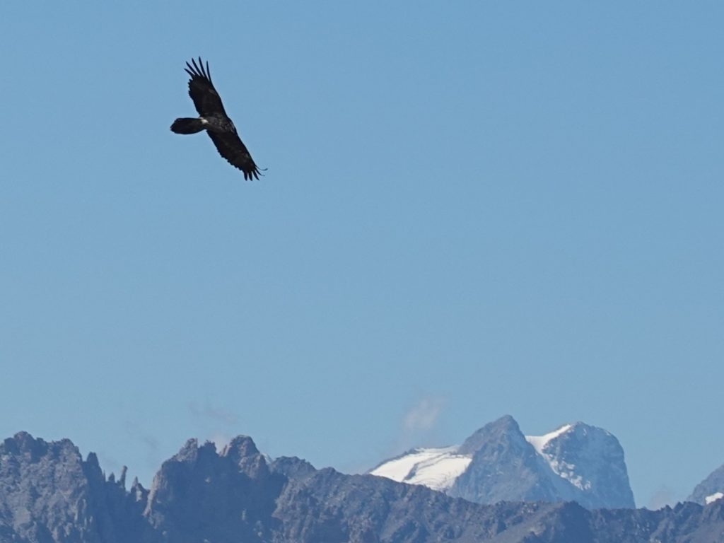
595. A rare Bearded Vulture soaring over the pastorl alm of La Barbier with the glaciers of the Ecrins massif in the background.

596.Lookiing down on the town of Modane in the L’Arc valley with the Cottian Alps in the background. The Cottain Alps are the next section: SSection 14.
After our picnic we started the long descent on the dry path. Initially we went through larch and Arolla pine woods. The Arolla pine cones were falling readily now and every one had been shredded by squirrels extracting the large hard pine nuts. It must have been a bonanza time for the squirrels who undoubtedly had more than they could eat and would be storing the excess up for the approaching winter. We dropped down the forested hillside, which reeked of hot resin, on the dusty zig-zag path for nearly an hour until we burst out into a wonderful clearing of knee high yellowing grasses with a few clusters of very well maintained alp houses. One of them had been turned into the Refuge de l’Aguille Doran. It looked very inviting and there were a few people sitting outside having lunch under red parasols. We lingered here a bit, resting our knees and orienting ourselves on the map before crossing the meadow on a small path. This path took us into the side valley to cross the small stream on the Pont de Chevres bridge and then a short while later another alm called Pierre Brune.

597. The beautiful alm of Pierre Brune in its hay meadow at about 1800m. This is were the steeper 700 metre descent to Modane starts in earnest.
At the charming cottages at Pierre Brune the descent became much more sustained and the path dropped some 700m through the dry firs and the black pines. The sun flooded in between the trees heating the forest and releasing the resinous odour which permeated everything. Dust particles hung in the air illuminated by the shafts of light and as we went down the path covered in cones, needles and surface roots we kicked more up. It was a slow tedious descent, especially where there was a bit more gravel, which were like ball bearings under the soles of our feet. It took well over an hour to carefully pick our way down until we met a steep track which was as bad, but quickly led us into the upper buildings of Luutraz, a suburb of Modane on the north side of the L’arc River. From here the path became paved.
We could stride out now down the deserted roads between the villas and dull government buildings, like the hospital and gendarmerie. Within a quarter of an hour we reached the river and then followed it downstream crossing on a tied arch bridge with a pavement on each side to reach the main street of Modane. Modane is not a picturesque town by any means, but is unpretentious, honest and simple. The L’Arc river forms the northern boundary of the town and on the south side of the river is a continuous row of 4-6 story buildings a kilometre long. To the south of this is the main road and on the south side of the main road, where in other towns there would be a corresponding row of 4-6 storey buildings, were railway tracks and sidings. Well to the south of the railway sidings was a motorway. Both the railway line and the motorway emerged from under the mountain at Modane where they had been in a tunnel for many kilometres to the east after going into them on the Italian side. As a consequence Modane had amazing transport links for such a small provincial town and the high speed train between Turin and Lyon stopped here. Our apartment was just west down this main street towards the centre of town. It was owned by a Bulgarian family of gymnasts who had been working in London for a couple of decades. They bought the rundown 4 storey building a few years ago and were doing it up to have 8 large family holiday apartments, especially for the ski season. The windows all looked over the river which flowed beneath us. There was the biggest health food store I have ever seen just beneath us which made up for the supermarkets each a kilometre away in both directions down the single main road. That evening we went out for a pizza in the town. As we finished Remy came in. He had had a huge day from Refuge de l’Arpont to here taking 11 hours, while Niels was taking it slowly from now. It was great to see Remy again and as he was having a day off in Modane also we arranged to have dinner tomorrow night. I did not write at all as I was tired and had the day off tomorrow.
Section 13. The Vanoise. 90 km. 33 Hours. 4950m up. 4680m down.
Section 13. The Vanoise. 29 August to 02 September 2022.