April 19. Yangri Kharka Rest Day. 0 km. 0hours. 0m up. 0m down. When we arrived in Yangri Kharka yesterday we were all tried, filthy, and wet and so was most of our equipment, especially the sleeping bags. So today was only going to be a day of rest and drying things out. Ramesh and Santos had the tent up and the sleeping bags out to dry before breakfast in the sunshine in front of the teahouse without being asked. The reliability of those two never ceases to impress.

I had a simple breakfast in the freezing cold dining room of the lodge and then set about getting the emails ready to update the website on Section 03. Arun Nadi River. Selecting the 37 photos from my camera and Bharat’s camera and putting captions to them alone took about seven hours. I just prepared the emails, like those from Section 02. Kanchenjunga which I prepared two weeks ago, when I eventually get online they can just fly out of the outbox.

In the afternoon I thought it best to practice a little with the harness, ropes, jumar ascender, and the figure of eight descender. Bharat and Santos were not that familiar with the gear and Dawa’s small brother did also not seem too acquainted with it. Dawa took everyone over to a small crag to practice. Dawa himself is a climbing guide and a Makalu Sherpa and I was immediately impressed with his competence and his emphasis on safety. He had all the harnesses set and instructed everyone with calm confidence. We played around on the crag for about two hours before heading back across the meadows to the lodge.

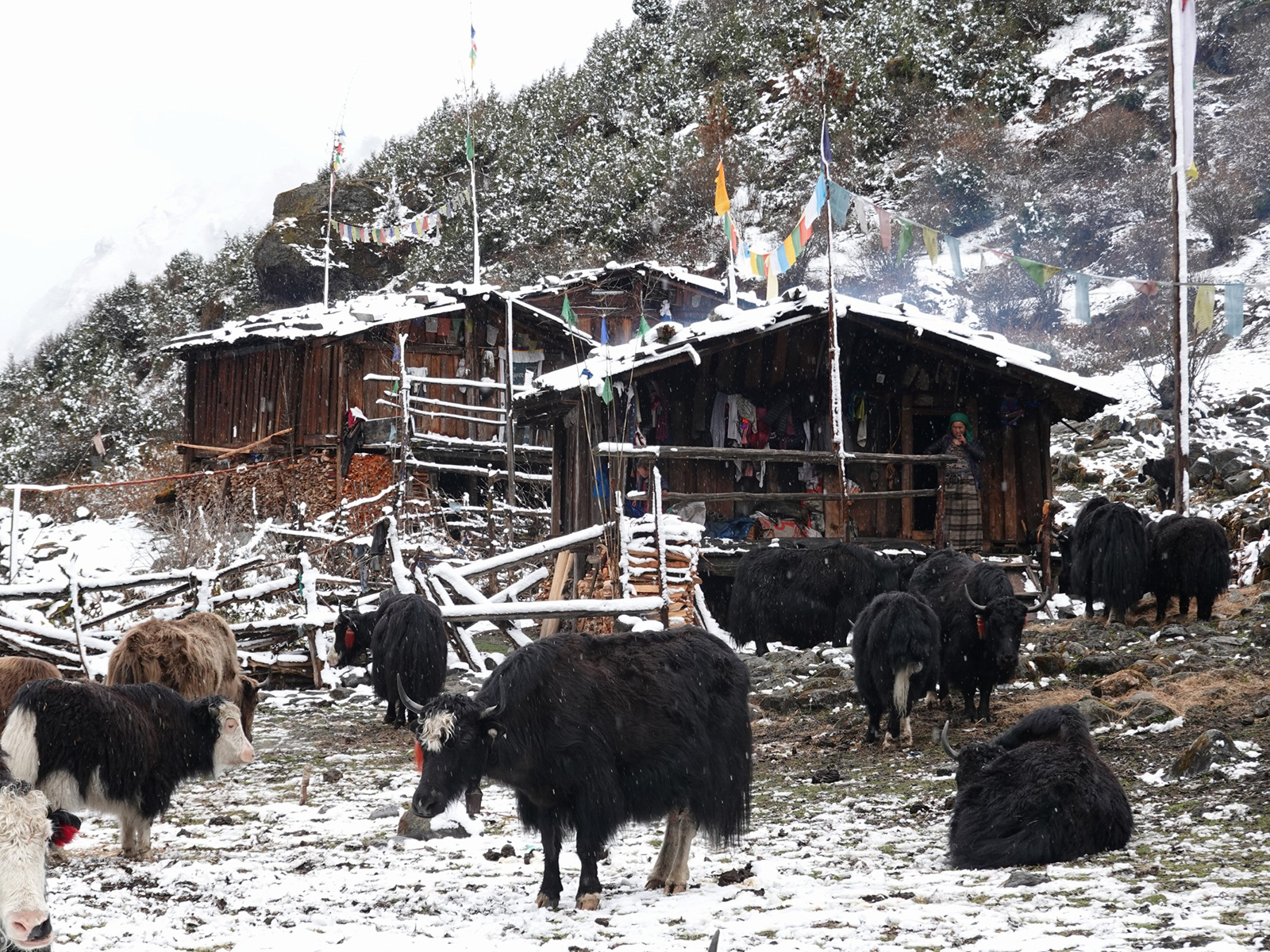
There were the odd snow flurries during the day but it was nothing like the last week. Indeed much of the day seemed to be in sunshine. The meadow was set under impressive snow covered mountains rising some 2-3 km above us. There were no yak in the pasture yet as the snows were just clearing. Around the meadow were Silver Firs rising up the flanks of the mountains for a few hundred metres until the rock and snowfields took over. On the meadow itself there were about 4-5 herding huts and also a small monastery. Running through the meadow was the Barun Nadi river which was now just a stream.

In the evening, a family of Bavarians arrived at the lodge, and I spent the evening chatting with them. They were the first real bit of non Nepali conversation I had had since leaving the Ghunsa some three weeks ago and I lapped up the conversation.

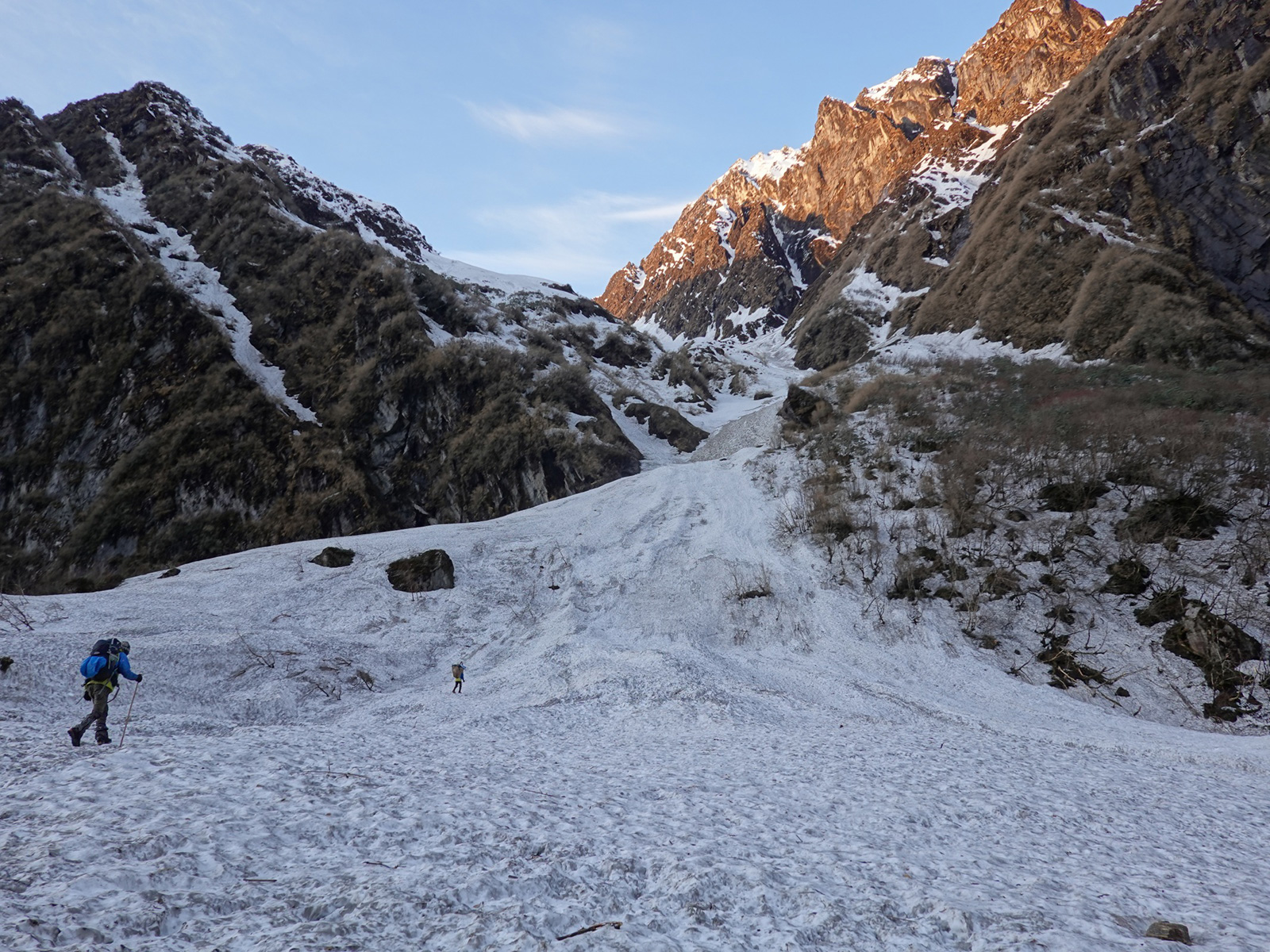
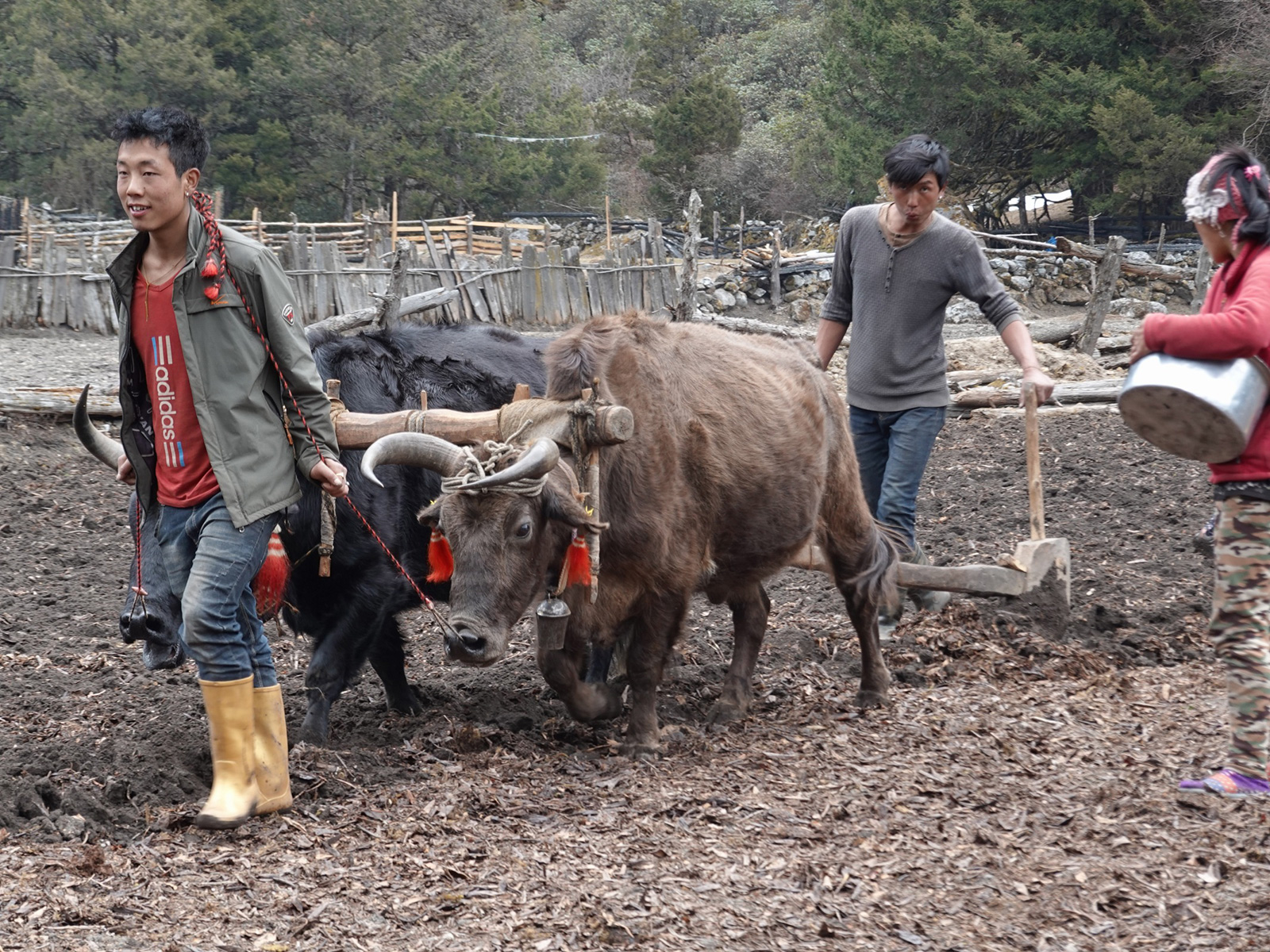
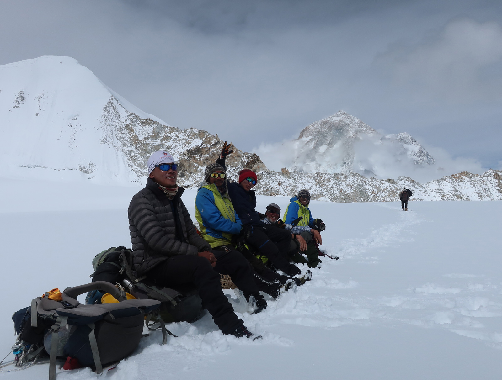
April 20. Yangri Kharka to Langmale Kharka. 9 km. 4 hours. 790m up 20m down. Today was our first day as a team of seven now, and reality first hit when I paid the bill at Yangri Kharka and it was over US$200. This did include some 30 meals though. We spent a while sorting out the gear and distributing it among the porters. It seemed Dawa’s 16 year old brother got a light load compared to Ramesh and Santos.  I set off before the others and sauntered up the meadow past the tiny monastery and into the forest with its birdsong and resinous smells. There were hardly any other people on the trail and it was pleasant sauntering through the forest. The path continued along the valley floor for about 3-4 km beneath vast rock walls before it headed north up a side stream.

085. Heading up the Barun Nadi Valley from Yangri Kharka to Langmale Kharka en route to Makalu Base Camp.

It climbed steadily through the forest for almost an hour beside a clear tumbling stream until it emerged on a meadow with a small stone shack. Again there were no yak here despite it being clear of snow. Ramesh and Santos caught me up here and we had a small chat before I headed off and they waited for the others to have a lunch of pre-boiled potatoes.

It was a further easy km to another meadow, Marek Kharka, through the last of the pines. At Marek there was a very small and rustic lodge, which would be more of a bhatti really. Ahead of me the valley was scared by a recent event of Biblical proportions. I learnt that part of a mountain, Peak 5, just up ahead on the north side had had a landslip into a lake. This had caused a wave which swept over the moraine walls and surged down the stream bed ahead. It picked up boulders much larger than houses, and swept down the valley obliterating everything in a swathe which initially was 200m wide and then only 100m wide. It was about 10-15 metres deep. It was responsible for all the carnage we had seen in the last two days as we walked up the Barun Nadi river. Apparently a couple of hundred yaks perished as this muddy, bouldery torrent swept down the valley and across the pastures.

There was a new path through the devastation marked by yellow paint, and it led to a area of undisturbed pasture above the Biblical carnage. This pasture was called Langmale Kharka and there was a lodge here run by a Sherpa family, who had a distinguished mountaineering pedigree, with two of the uncles being the first siblings each to complete all 14 of the 8000m mountains, and father who owned the lodge had done about eight of them. The parents who ran the lodge had left their 19 year old daughter to run the place, as it was quiet, while they went up to Makalu base camp to run another lodge their which was busy.

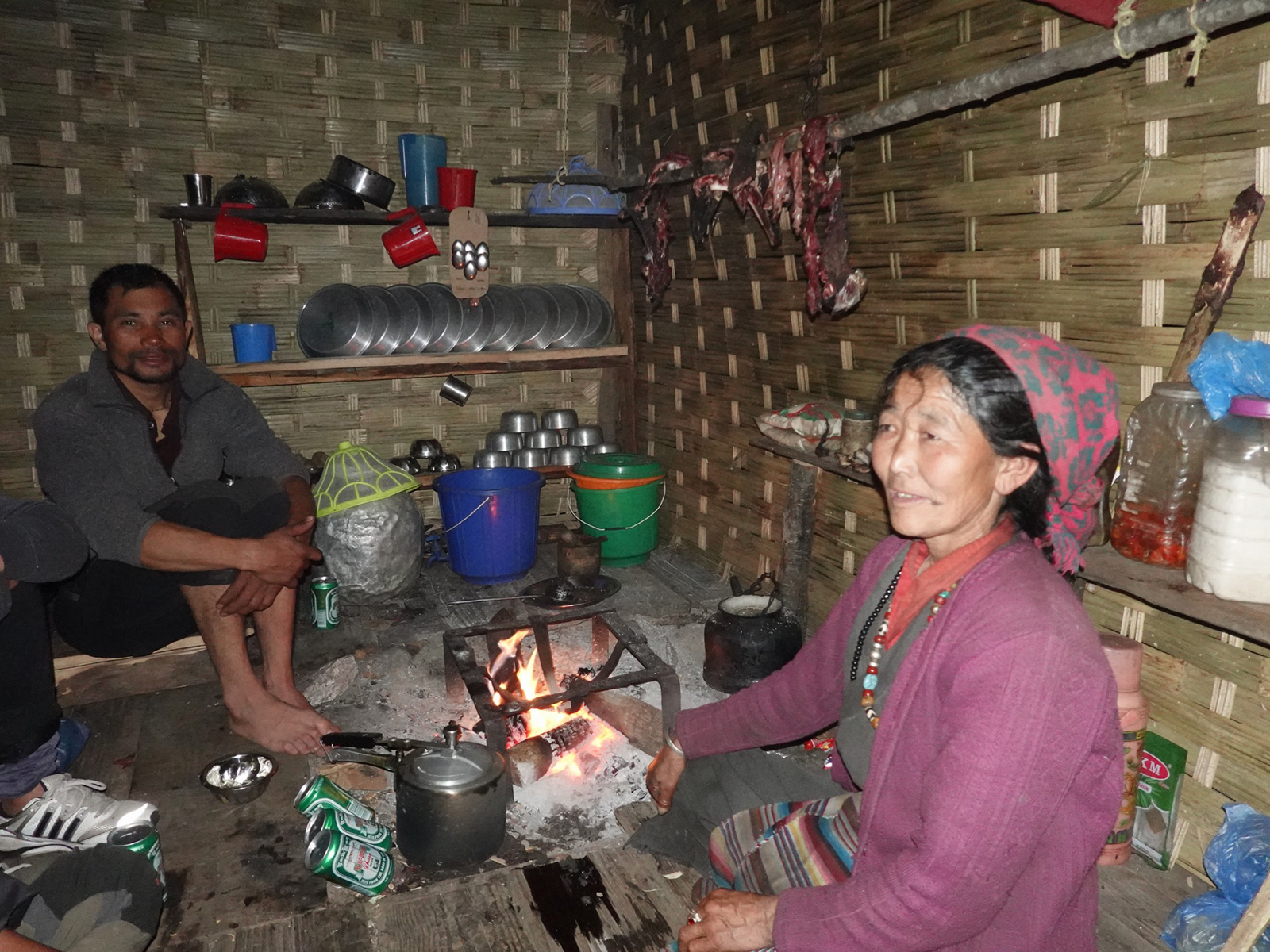
I was here for a good two hours before any of the others arrived after their extended lunch. But in that time the mist and snow showers had arrived. I got a freezing room, and hired a kitchen – meaning that Ramesh and Santos could cook for all, and we did not have to buy meals. It was only about US$6 to rent the kitchen, and we had to buy the raw food on top of that. The six guys could also sleep in the kitchen at night.

The lady put the stove on around 1600, earlier than usual, and filled it with yak dung and juniper scrub so it gave off its distinctive incense like smell. The stove quickly became the focus and everyone crowded round it. We were joined by a young Austrian couple.

April 21. Langmale Kharka to Makalu Base Camp. 8 km. 3 hours. 490m up. 120m down.  I had to go out in the night and it was a glorious night. It was slightly below freezing with a full moon. With all the snow about reflecting the moonlight it was bright enough to cast shadows. All the mountains in the area were crystal clear. By morning however, my hopes of a full moon bringing a change in the weather were dashed as the valley was full of fog and freezing cold. To everyone’s delight however the sun soon started to burn it off and by 0800 it was gone.

In one corner of the meadow at 4400 was a small walled off area where the teahouse owner’s family grew potatoes. At the moment there were none, but there was a cluster of Kongma, or Himalayan Snow Partridge who were leking, or courting, and the dozen or so birds were chasing each other in pairs. The returning sun raised the spirits of my team and everyone moved outside to finish their breakfast tea. I paid the bill and noticed that the hiring of the kitchen was an enormous saving, with our total bill only coming to US$50 for the seven of us, with me accounting for half.

I left with the others around 0900 but soon overtook them as they were laden. It was a very easy walk up the north side of the Burun Nadi which was a mere stream now. To the south, Peak 6 dominated, with its ramparts of fluted snow and its hanging glaciers perched on shelves high up on the mountain side. I walked up on the north side of the terminal snout of a glacier and could not look over the moraine wall, but according to the map there was a glacial lake hemmed in by the moraine walls at the end of the glacier. I was surrounded by near 7000 metre mountains, in glorious sunshine with very little snow around, on a near level path in a great mood when I stepped onto the meadow at Shershong. It was something of a Shangri-La in the warm sunshine, with more clusters of Kongma playing on the dried grasses between boulders.

Dawa’s brother, Chirring, caught up here and I chatted with him as we walked. He was just 16, had recently left a monastery in Boudha, Kathmandu and this was his first trek. I was quite surprised Dawa had brought him. If I wanted a thanka painted he would have been the man to ask, but to go over Sherpani Col as a porter on your first trek was something else. However I later found out a number of porters had let Dawa down, and as a last resort he turned to his brother, who was in for a baptism of fire.

We chatted as we sauntered across the meadow and I found his monastery education had been quite thorough, and included English which he was quite good at. I had previously noted how dapper and well dressed he was compared to the others. Whether he will be after the high passes remains to be seen. He stopped for a break and I carried on across the meadow, turned north, and started a gentle climb up grassy ridges to Makalu Base Camp.

According to the map Makalu was ahead of me in all its glory, including the summit, but the clouds had returned and the whole spectacle was lost. Slightly to the east though, the cloud was more patchy and out of the top of it poke the summit of the enormous Sherson NW which was approaching 7000m. I strode towards it on the easy path, then crested a rise and saw a floodplain below me, with the buildings of Makalu base camp at the far end surrounded by a sea of yellow tents.

I made my way down across the moraine to the warm dry floodplain, crossed the Barun nadii on stepping stones and then climbed the sandy bank and reached the rustic hotels. The yak hotel was the best and run by the same family as Langmale. It was at nearly 5000m but what struck me most was the lack of snow and warm temperatures. Just a few days ago we were only 30-40 km to the east and up to our thighs in rotten snow formed from a metre of recent hail and sleet from thunderstorms. I think the valley we are in is in some sort of rain shadow caused by the large mountains to the south. All the bare brown earth absorbed the sun to create the warm air. There were no yaks here as they were all waiting around Tashiigoan waiting for the snow to clear a bit more before a few hundred of them were driven over the Khongma La pass to the pastures along the Barun Nadi river.

Most of the yellow tents seemed to belong to people who intended to climb Mount Makalu. They came in and out of the dining hall, but few looked like they had any chance of reaching the summit. They seemed to be clients of Seven Summits Expeditions. I got a rustic room in a corrugated iron annexe to the building with Bharat, Dawa and four porters rented the kitchen again. It was a large bare room with a gravel floor. It looked bleak but they all insisted it was great. They bought some kerosene, rice and other foods and cooked a meal. In the evening they said they would put the tarpaulin down and then the thin foam mattresses on top of that. I wrote in the dining room mid afternoon which was largely deserted.

April 22. Makalu Base Camp to Swiss Base Camp. 7 km. 3 hours.470m up. 120m down. I did not sleep well at Makalu Base Camp. I had to get up on the hour every hour to go to the toilet because I had drunk too many teas to try and keep hydrated. It was perhaps also the body coping with the higher altitude and shedding water. I vowed not to bother with hydration and not to drink anything after 1800 after my disturbed sleep. However on the positive side, during one of the visits the sky was crystal clear and there was almost a full moon. The brightness illuminated the whole of the south side of Makalu to the extent I could easily see all the flutes of snow and even the seracs. The mountain virtually started to rise from where I stood at the base of it. It rose almost four vertical kilometres over me.

We had a lazy start as it was just a short day and Ramesh had a lot of supplies to organize. We went through the small shop to see what he needed, like rice, dahl, noodles, spices, cooking oil, biscuits, and seven litres of kerosene. The whole bill came to over US$150 but that was enough for the seven of us for six or seven days until we reached the luxury of Khumbu, or the Everest Region.

I was quite glad to be leaving Makalu Base Camp. The teahouse hosts were very nice, but the place was overrun by expeditions to climb the mountain. There were self-important men with walkie talkies strutting about the place overwhelming any conversations, there were climbers with big egos laying down tales for others to match, and there was general business with dozens of aloof Sherpas and busy porters making up loads to carry up to Advanced Base Camp. When we had all eaten, it was a delight to leave the turmoil of the place to start heading up the valley, now with the infant Barun Nadi river flowing through a series of glacial lakes surrounded by the rubble of moraine.  As we left a helicopter arrived to drop off another batch of climbers and supplies.

Initially the path kept on top of the moraine ridge which was left by the now retreated Barun Glacier and we could look down and see lakes in the trench of rubble. They were still frozen. Across the valley was the opposing lateral moraine, and then Makalu rose relentlessly, displaying its awesome south face right to the lofty summit where a plume of snow was blowing off it in the jet stream. The path was pleasant for a good 3 km with the off snippet of meadow between the boulders, and it was easy to follow.

However after a good hour the path ran into a hillside full of rubble and boulders. It disappeared but its route was marked out by a series of cairns. Some of the boulders were car sized and one had to be very careful when weaving a path amongst them. Our speed slowed right down to about a km per hour as we hoped from the top of one boulder to another. There was plenty of opportunity to twist and ankle or bash a shin. We picked our way through these boulders for a good hour and a half, and at some point passed the junction to Makalu Advanced Base Camp where everyone else was going. Their path crossed the bouldery glacial trench while ours continued to traverse the west side passing two small side valleys which once housed the glaciers which had deposited the stones on which we were now gingerly picking our way forward.

By now the clouds were covering the tops and the mist was building in the valley. Indeed there was the odd snowflake. Unusually it was coming down the valley from the north rather that the prevailing south. We reached what we thought was Swiss Base Camp – a sandy, small side valley, strewn with enough boulders to make pitching the tent difficult. Some wanted to camp here but I pointed out tomorrow was a huge day and the more of it we did today the easier it would be. Ramesh and Dawa agreed so we pushed on. However after just a short km we reached another side valley with a glacier in it higher up. It had a sandy floor with plenty of campsites. It led up to East Col, a seldom used alternative to Sherpani Col. However the path which Ramesh and Dawa remembered had changed dramatically and it now climbed a rocky spur from here to enter the next valley. The old path seemed to have vanished in a landslide of the moraine wall.

086. The valley of stones and boulders from Swiss Base Camp to Sherpani Col Base Camp

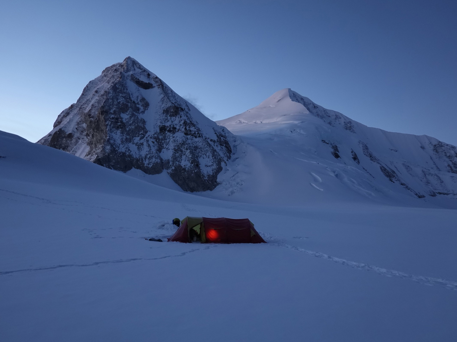
With it now snowing more constantly we decided to put the tents up here for fear of climbing and not finding anything for hours. We put both tents up, the six Nepalis in the big tent the four of us had exclusively used, while I christened the lightweight three man tent nearby. Once we had tea I withdrew to my tent to write while four of the others took a load of equipment up the steep climb and beyond perhaps even to Sherpani Col Base Camp at around 5700m which was estimated to be three hours away. The snow stopped soon after they left as we suspected it might, but the sun never really returned to warm the afternoon. What really shocked and delighted the four of us who endured such misery in the deep snow last week was just how little there was here. We were obviously in a rain shadow because at 5150m there was no snow at all bar the 5cm which fell this afternoon, and that was melting fast now.

April 23. Swiss Base Camp to Sherpani Col Base Camp. 9 km. 4 hours. 540m up. 80m down. Dawa wanted not only to get to Sherpani Col Base Camp today, but to go up to Sherpani Col itself to set the ropes up. He intended a very early start tomorrow and wanted to do both Sherpani Col and West Col in one day, which is normal practice. Due to this we needed an early start and I pushed for up at 0300 and away by 0500, knowing it would get negotiated to 0400 and away by 0600. The main consideration was how cold it would be for Santos and Ramesh to make breakfast for all at that time.

We got up at 0400, and it was a glorious end to the night with the large moon shining on the whole of Makalu. But it was very cold. I eventually packed my tent at 0600 and we all set off pretty much together. It was to be a very stony day. The first path was a steep climb up moraine to get out of the valley where Swiss camp was, and round the spur.  We got great views over to Makalu and up the Barun valley to the glacier to the mountains on the Tibetan border. There also seemed quite a good route up the valley Swiss Camp was in up to East Col, but we could not see East Col itself. According to Ramesh who had been here before, this was a new route, the old route dropped to the glacier before climbing up the valley where Sherpani Col Base Camp was, and this climb went through a deep valley with rockfall on each side.

Once we gained the spur there was a traverse round it into the valley above the rockfall areas Ramesh mentioned. However it was all moraine, initially stable for the first km or two and then newly exposed or a fresh landslide which was much less stable. Much of our path was covered in a couple of cm of new snow. It was very slow going, and every step had to be taken with care. There was no scope to nonchalantly saunter along with your hands in your pockets. As the path met the moraine covered valley floor we reached the stash of ropes and kerosene the four dropped off.

Above us now, the glacier coming down the valley forced up to the north side, and we started a rising traverse up moraine for a good hour. We were all tired and breathing heavily on this stretch due to the altitude. The weather was still fantastic and Makalu loomed beside us, even its summit crystal clear. Eventually we could spy a cluster of cairns on the ridge and knew the end was near. On reaching them the ground levelled off, and we could walk across easy sandy soil to a sandy basin at the bottom of a steep bit of stationary ice in the glacier which was now melting as it was not being replenished. At the bottom of this ice was Sherpani Col base camp which could take 10-15 tents.

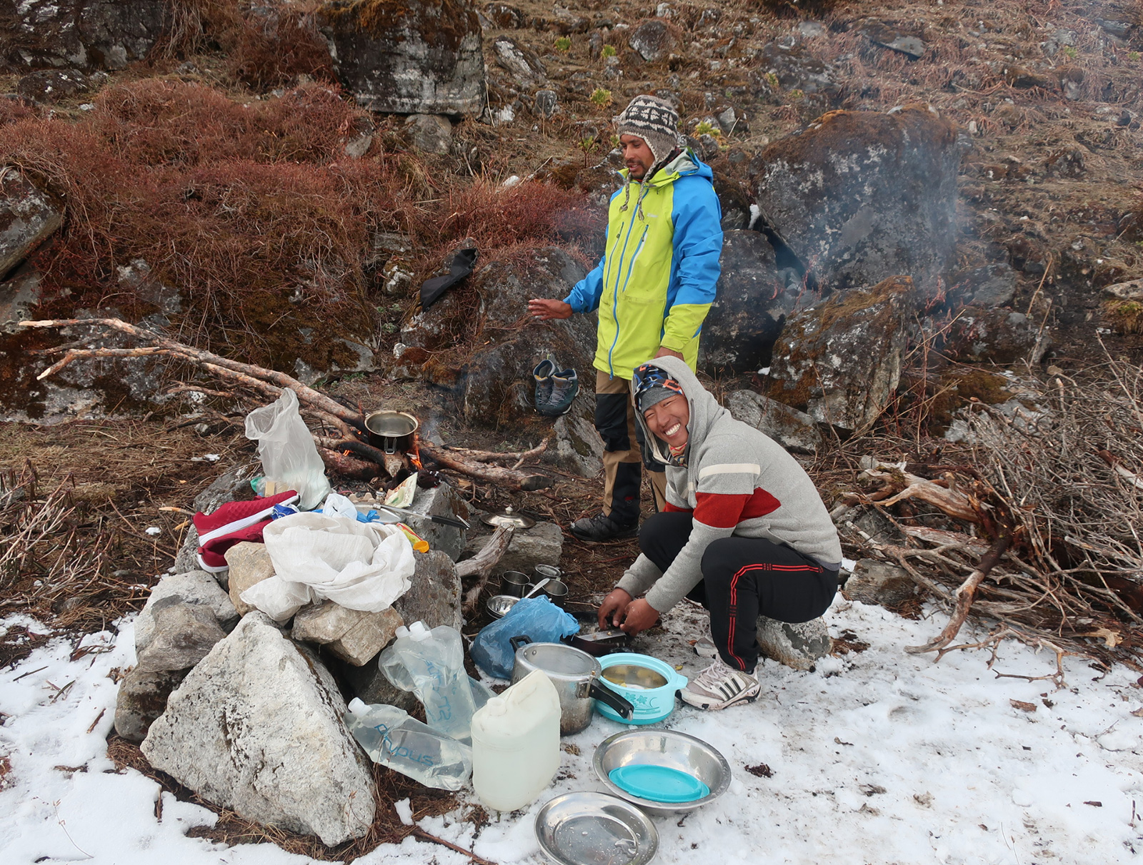
088. Ramesh in his kitchen made out of wire crates and old tarpaulins left at the campsite. The homemade windbreak made the kerosene stove more efficient.

We had the place to ourselves and put the tents up and made a wind proof kitchen from the debris and detritus of other groups. Ramesh then cooked a meal. After the meal Dawa, Ramesh, Pinzu and Bharat when up to the col to fix the ropes as the weather clouded over.  I had a snooze and Santos kept the eagle eyed chuffs away who were scavenging for an unattended bag of food. Dawa and crowd returned around 1800. However it seemed the landscape had changed in the last seven years since Dawa was last here. The snow fields on each side of the pass had retreated and there was more climbing and abseiling involved for all seven of us and the seven loads. Secondly the glacier between Sherpani Col and West Col was now riddled with crevasses and it would take more time. As a consequence Dawa did not think it possible to do both cols in one day, and we would have to camp at 6000m. It meant the early start was postponed from 0100 to 0300.

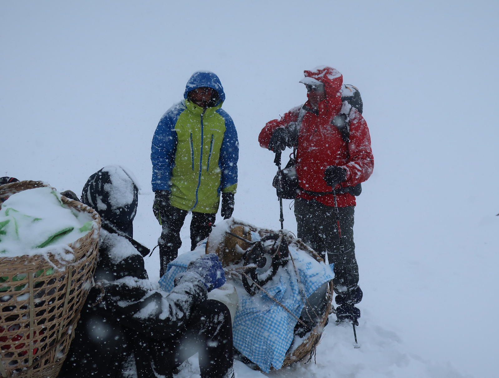
April 24. Sherpani Col Base Camp to Baruntse Advanced Base Camp. 9 km. 7 hours. 590m up. 200m down. Today was the big day where we hoped to do at least one 6000m pass. The alarms were set for 0300 and as usual Santos and Ramesh were up soon after in the bitter cold making breakfast for everyone else who were still in bed. It had all the promise of a beautiful morning when we set off at 0530, having had to abandon a few tent pegs in the frozen soil. Our first task was to gain the smooth glacier above the camp and we did this as the sun lit up the first peaks in front of us. The huge bulk of Makalu just behind us blotted the sun for a while, but eventually we were in the bright sunlight with steep snowy mountains on each side. The temperature rose quickly and I had to stop to remove all my thermals.

The route up the glacier was a very simple one, and in the bright morning light it was all laid out in front of us. However we were all feeling the effects of the altitude as were approached 6000m, and I was gasping for breath. We slowly plodded up the glacier in a large crescent as it curved for the best part of two hours until we reached the foot of the rocky col which was called Sherpani Col and supposed to be 6180 metres. Dawa had already been here last night and rigged up a fixed rope up the rocky climb. The first half was a steep snow field at just 40 degrees, and the second half went up the rocky slope also at about 40 degrees. The fixed rope was a bit unnecessary especially as there were some wire cables in place – like a via ferratta but thinner. The porters ignored Dawa’s fixed rope and used the cable instead. I used Dawa’s fixed rope out of obligation.

089. Looking up the glacier to Sherpani Col which is just right of centre. The height of Sherpani col given as 6180m on the map.

Curiously there was a single Russian camper here, thin and wiry and 57 years old. He had an enormous Tatonka rucksack, perhaps 130 litres, and it was full. He had camped here for a couple of days. The porters reckoned his rucksack was 40kg. He was obviously hanging out waiting for a group to come along and help him over the col. We felt a kind of duty to help him. He had met Dawa last night and had been ferrying loads up the col before we arrived in anticipation. I thought it was a bit irresponsible of him.

090. Looking back down the glacier to our campsite. The mountain dominating the background is Makalu, the 5th highest in the world at 8468m.

The view from the top of the col was fantastic. Down the valley we’d come up was Makalu, beneath a clear blue sky. On the other side of the col was a fantastic vista over to the gentle pyramid of Baruntse. At 7152m it is one of the easier 7000m peaks and it had a nice symmetry. However what really astonished me was a vast bowl of ice perhaps 2km wide and 5km long into which all the surrounding mountains’ glaciers flowed. It was a kind of Himalayan Konkordia Plass as in the Bernese Overland. The glacier which collected from all the mountains and filled the bowl was called the Lower Barun Glacier. Its smooth surface stretched 2km to the west to West Col – our next 6000m pass. It looked a relatively easy crossing without much height loss or gain. The only problem is we had to get down from Sherpani Col and onto the glacier.

091.Going up the steeper snow slopes to gain the rocky ridge on the right which leads to Sherpani Col. The route up the ridge is secured with old rusty cables like a poor man’s via ferrata.

092. Santos, ever the joker, rejoices after hauling his enormous load to the top of Sherpani Col.

093. Looking across the Lower Barun Glacier from Sherpani Col to the slightly higher West Col at 6190m. The distance is about 2 km.

The descent was not easy. It was perhaps 70 metres in all to the bottom of the steep rocky 45 degree slope. The slope was made of fragmented rock which had been recently exposed by the diminishing Lower Barun Glacier. To make it worse, the bottom of the slope was a deep ice trench with a few crevasses in it, and we had to cross this too before reaching the smooth glacier beyond. Dawa abseiled first on the rope he set up and checked for loose rock and ice, then he climbed back up.

I volunteered to go next, hoping to show off some of my 15 years as an industrial abseiler and using a figure of eight. Dawa however wanted to lower us all using a stich plate. I bowed to his diligence and he started lowering me. I used the existing cable to clip into as a back up. Ofter Dawa would lower me past the point where I could unclip from the via ferratta, so I would have to haul myself up to unclip. Eventually we got the communication sorted and with five minutes I had slithered and crashed down to the bottom of the trench in an inelegant fashion. I sent my harness back up for the next, found a way across the crevasses to the main glacier out of danger of rock fall and watched the others and baggage descent for the next two hours.

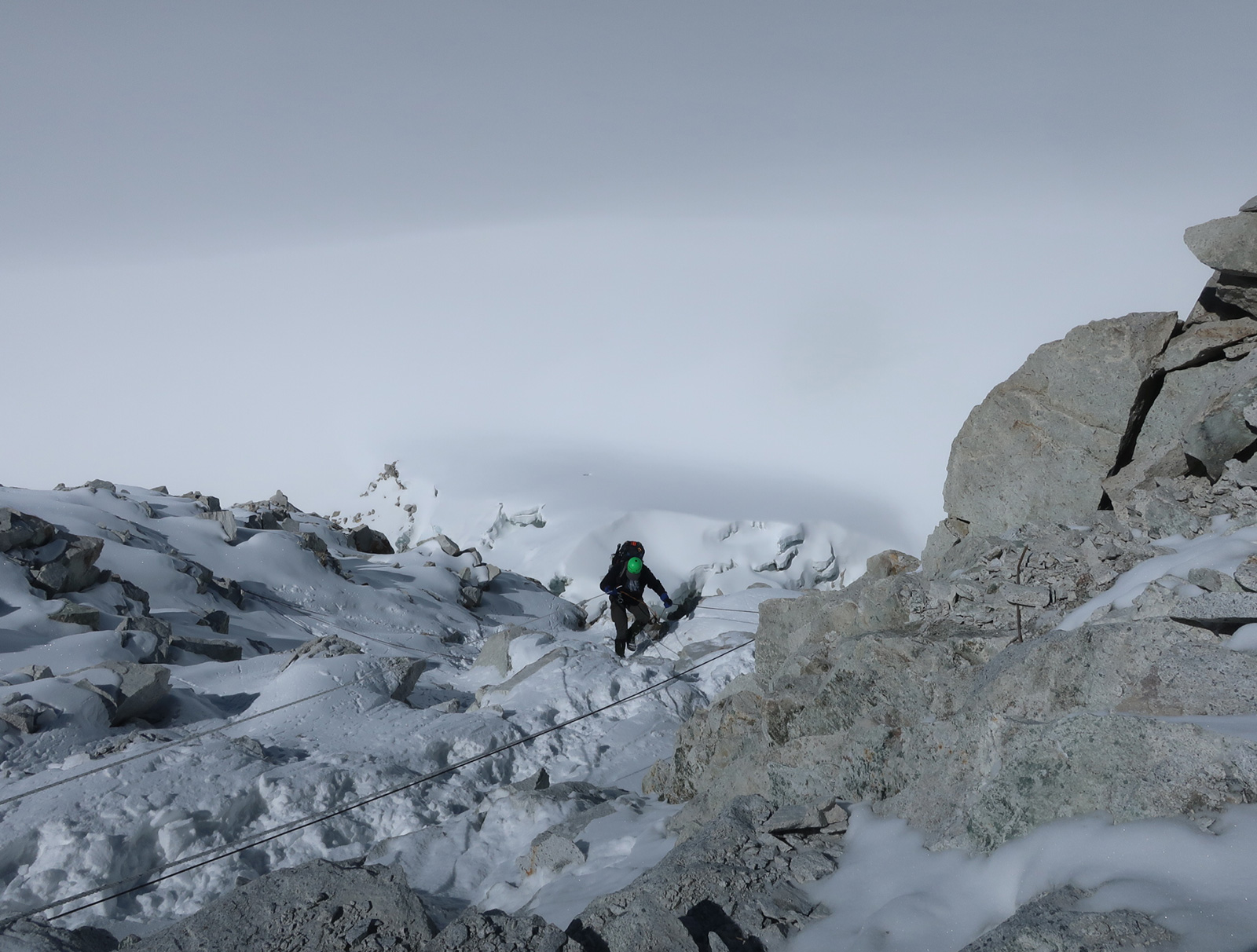
096. Me descending the 80-90m steep slope from the crest of Sherpani Col to the Lower Barun glacier which was heavily crevassed at the bottom of the slope.

It was quite frustrating watching the others come down in the same bouncing manner. Santos managed well, Bharat was cautious and then positioned himself midway to direct the loads. The loads were simply pushed off the top, with at least two tied together. This was recipe for disaster as there were so many rocks for them to get caught in. The rope was at least 130 metres, and it would have been easy to clip the loads onto the tail and then Santos and Pinzu, who was also down, could have pulled the tail and helped bunch the load in a poor mans Tyrolean. In retrospect on the rise the other side of the crevassed trench we could have used four snow anchors, a jumar and a couple of carabiners to set up a perfect Tyrolean, and Dawa could have lowered the loads one at a time very quickly. It was the loads which took the time, with Bharat moving gingerly from rock to rock  to give each load a boot when it got wedged. I shouted some advice but it was too far to be understood, so I lay on the glacier and watched.

The most spectacular incident was when my yellow bag, containing my sleeping bag, became detached from a load and slid and bounced down the rocks, destined for a crevasse. Santos, who was clipped into the cables, ran across the slope and launched himself like  a goalkeeper and just grasped the bag. It was like a penalty save. Eventually all and everything was down, including the enormous Russian rucksack which was particularly stubborn. I vowed I would be involved in the next lowering of baggage as it was lucky no one was hurt or baggage lost.

094. Bharat on Sherpani Col with the Lower Barun Glacier in the background.

We regrouped on the glacier in the sun as some clouds were building. We were all tired, especially Dawa. We decided we would just walk the 2km to the top of the next descent, West Col, 6190m and camp there and then descent tomorrow. It was an arduous 2km walk across the glacier which was largely crevasse free. But in the early afternoon the snow was soft. We look it in turns to make footsteps with Bharat gallantly doing the lions share. The tents were up by 1500 and everyone withdrew into them. I had heard this was a particularly cold place to camp so I put on all my clothes and I was still in exile in the single tent.

097. Pinzo at the bottom of the descent west of Sherpani Col waiting for the first packages to come down to hopefully divert them away from the crevasses where they might become stuck.

098. After the descent from Sherpani Col we walked across the Lower Barun Glacier to West Col. It was only 2 km but the altitude and deep snow made it hard work. Here we are having a rest.

099. The large tent which the 6 Nepalis occupied under the glacier covered pyramid of Barruntse at night. This camp was at about 6150 on West Col.

25 April. West Col Camp to Seko Pokhari. 19km. 10 hours. 230m up. 1200m down. It was a bitterly cold night. Inside the tent I measured -17 and in the vestibule it was -22. It was a completely still and starry night without the slightest wind to take my vapours away so they all condensed on the inner tent in a cm thick layer. I had all my clothes on including my Gore-Tex jacket and balaclava, and it just kept the cold at bay and I slept well. It was way too cold for us to start early and even the kerosene stove was partly frozen. I think we all wanted to stay in our sleeping bags until the sun rose and where we were camped it should be early around 0600.

100. The large 6 man tent on West Col during the day. The large glacier covered pyramid in the background is Baruntse.

The Russian who was camped nearby came over and passed us and went to the old descent route. He was dwarfed by his enormous rucksack and looked quite frail. He spent a good half hour looking at his options and they must have all horrified him as he offered Ramesh 1000 rupees to help him. It was Dawa who would eventually be the helper and he scoffed at this. I suggested US$100 and this seemed to be accepted grudgingly by Dawa who would essentially be rescuing the guy. I felt we were partially to blame by helping him over Sherpani Col yesterday and essentially trapping him between two very difficult and potentially dangerous cols. He was essentially way out of his depth. It was agreed.

102. Our campsite on West Col after the very cold night which got down to minus 26 outside the tents and not much less inside. The pass centre left is called East Col, 6146m.

We packed up the tent in the sun with Baruntse and Makalu dominating the large array of mountains. Then we all made our way up to the new descent point. The problem was the glacier on the west side of the descent had shrunk sufficiently that the abseil was longer, more stones and rocks were exposed and there were crevasses at the bottom of the abseil which was about 160 metres now. Climate change is making these cols more difficult. We had to negotiate a couple of crevasses on the top of the ridge as we made our way to the new anchors of the new abseil point.

I thought the whole abseil was down a 60 degree snowfield. However the abseil went down a rocky ridge beside a snowfield which had quite a few rocks in, and a couple of small crags at the bottom. Rinzo and Santos went first and I went third, without my rucksack, which I thought would just be lowered down the snowfield. This time I used my figure of eight for abseiling but the rope was a second hand fixed rope from a previous expedition. It had frequent anchor points and I could not get a good rhythm. I dislodged a stone which built up speed as it tumbled down building up speed. It missed Santos by about 10 metres! The ridge was full of loose rock which was all covered in 5cm of new snow.

With the three of us down the Russian started. He was very cautious and took ages. Santos, Rinzo and Myself each took 10 minutes but he took well over half an hour. And we had to wait for him to finish before we could start lowering the loads. Ramesh impatiently got one ready and lowered it 10 metres in anticipation but inadvertently released a small avalanche of the new powder snow which mush have been 15-20 cm thick by the time it hit the Russian, but it was light and fluffy and swept round him. He eventually got to the bottom and joined us.

The first baggage was my big red bag containing all the sleeping bags and two holdalls of climbing gear. Its descent was smooth until it reached the crags at the bottom. Here it failed to divert down a small gully and arrive at our feet and instead carried on down through a small crack and went into a lateral crevasse at the side of the glacier. Santos reacted quickly and took my harness to climb up to the top of the junction between the gully and small crack but he could not manhaul the bags himself, and Dawa had to down climb some 150 metres, rig up ropes and haul the baggage out.

105. Santos on the ridge just above the abseil point down the west side of West Col, 6190m. The old abseil point is a few hundred metres to the north but is not considered safe anymore.

While he was down Ramesh sent his treasured basket with the camp kitchen. About half way down it got stuck and turned upside down. I saw a huge rock hurtling towards us and expected it to break up into 20 pieces the next time it hit a crag. To my relief I realized it was the sack containing all the dinner plates. It missed a crevasse and came to rest on the snow. Then I saw the pressure cooker spinning high in the air. It landed at out feet slightly dented.

109. Dawa keeping a watchful eye on me while I start the 160m abseil down the west side of West Col. The route goes down a ridge with lots of fractured rock beside a long snowfield.

Santos stayed put at the top of the gully dodging kitchen gear as it came down while Dawa climbed up again to lower the final load. It went smoothly until it got to Santos who spent a lot of effort guiding it into the right gully. However there was a bit of miscommunication and Dawa suddenly let out two metres of rope and the three packages slipped into the crack above the crevasse. I could see Santos’s frustration as he had done everything to prevent it and could do nothing now. Dawa had to climb down for the final time taking the ropes, while Ramesh climbed down with my rucksack.  Soon all the baggage was assembled, the Russian presented with his rucksack and the group could move on.

The weather changed very quickly from a beautiful blue sky to snow showers as we made our way down the glacier towards Baruntse Base Camp where we assumed there would be food and lodging. It was a taxing descent with soggy moraine and deep wet snow. It took a good two hours to weave out way down. At the base camp we were disappointed to see it was just a lot of empty tents and no one was there. Between us and Amph Labsta base camp where we hope to be tomorrow was the vast trench of a glacier with a crumbling moraine wall on each side. The latter made it impossible to cross.

107. Our climbing guide to help us across these 4 high difficult passes was Dawa Sherpa. Here in his element on West Col.

We would either have to go above it across some very looking terrain of boulders and crevasses which looked unchartered even though the map showed the GHT went this way. Alternatively we would have to walk some 8-9 km south down the moraine wall to a lodge which Dawa and Ramesh had been to at Seto Pokhari at the end of the moraine. We chose the latter. The walk was frustratingly long as we would have to come up the other side tomorrow. However the walk was in the valley between the moraine wall and the original mountain. It is a place of stable rock and vegetation and was pleasant to come down. It was tired as my breakfast muesli had long been burnt. All the guys were tired, even the indomitable Ramesh and Santos.

104. The route west across the Honku Basin to Amphu Labsta Base Camp is much shorter than the previous picture but involves a heaving crevassed glacier and sections of loose moraine and is somewhat risky now.

We eventually got to the lodge as it was getting dark at 1900. It was a long stone shelter some 40 metre by 10 metres. At one end was a kitchen with kerosene stoves and at the other as a large U shaped sleeping platform made of stone and turf onto which mattresses were placed. It was actually very characterful and cosy. It was very expensive with Dalbhat at 1000 rupees however they let us cook ourselves. The guys bought some dried meat to replenish their bodies, and Ramnesh cooked it. He also made me a great garlic pasta. His day had started in the freezing cold of our West Col camp before 0600, and here he was at 2100 still going. If we are a car, Ramesh and Santos are the engine. I wrote the blog while the others played cards and joked with the owners who were not Sherpa, but Rai from Gudel, who were running this tea house at about 5100m.

112. From the bottom of West Col we decided to take the longer, safer route involving a long detour to the teahouse at Seko Pokhari, which was like a small stone barn.

April 26. Seko Pokhari to Amphu Labsta Base Camp. 8 km. 4 hours. 490m up. 70m down. I went to bed at one end of the main hall on a soft mattress. Ramesh was not far behind and grabbed a mattress nearby on the sleeping platform. The others seemed to be playing cards and digesting some of the 5kg of pork Dawa had bought for them. I was out like a light. In the morning I woke early after a great nights sleep and Ramesh promptly got up and made a tea for all. It seemed all but Ramesh and the young Cherring, Dawa’s young 16 year old brother on his first trek after leaving a monastery, were the only ones who did join in the drinking session last night. It seemed the two passes we did were a major cause to celebrate as there are something like only four or five trips a season over these cols.

In the morning Ramesh made everybody breakfast, very much at home in the kitchen he was borrowing. Dawa and Bharat played music and the whole group suddenly erupted into dance with Ramesh sometimes joining in with frying pan in hand. Everyone was relieved and delighted to have got over these two cols without incident. It seems the next two big cols Amphu Labsta and then Trashi Labsta are not so challenging or dangerous. Morale was very high in the team. Ramesh made me a huge pasta for breakfast and then boiled a vat of rice to have with the other half of the pork. Breakfast was a slow affair and Santos especially was the worst for wear. After breakfast I set off before the others as I wanted to get up to Amphu Labsta Base Camp before the weather closed in as it did most afternoons.

114. Spirits were very high in the team having crossed Sherpani and West Cols; two cols Nepalis find formidable. There were frequent impromptu dances and backslapping during breakfast at the relief of having crossed them.

This time I went up the west side of the piles of moraine in the valley. It was a very pleasant walk for about 3km as the path followed the stream across the alluvial plain below the large glacial lake, then meandered across the valley floor from small frozen lake to small frozen lake across a series of braided gravel channels. Ahead of me the glacial valley was starting to open up and I could see our route from yesterday. At the km long frozen lake, at the end of the rubble at the glacier’s snout, the path started to climb up the crest of the lateral moraine, slowly gaining height above the lake. I could see where Baruntse Base Camp was, where we were disappointed there was no one yesterday. However I could also see there was no way across the glacial trench between it and where I stood now, less than a km away.

115. Walking up the west side of the Honku glacier en route from Seko Pokhari teahouse to Amphu Labsta Base Camp which took about 4 hours.

The only way across this glacier, probably called the Honggu Glacier, was either up at the top where it was crevassed and covered in boulders, or below the long lake, though not necessarily all the way to the Seko Pokhari teahouse. However the extra 60-90 minutes last night and again this morning were probably worth it for the comfort and luxury after three nights in a tent over 5000m. The kitchen charge was 4000 rupees, and this meant Ramesh and Santos could cook for us and save me a fortune as a Dalbhat here was nearly 1000 and I would have needed to buy 14 for us in all.

The more I climbed the more I saw just how tricky it would have been to go round the top of the glacier and the small steep rocky ridges. This way would have taken 4-5 hours anyway not much shorter than the extra time we used. As the path climbed, more and more of the route yesterday was revealed until it was possible to see the whole of the West Col descent. It did look formidable from here. The gently climbing path now climbed more steeply for a bit and delivered me to the edge of a crescent shaped lake.

116. Looking across the moraine trench of the Honku Glacier to the alternative route from West Col to Amphu Labsta. on the right is West Col and the steep descent, then the crevassed glacier, then the moraine piles and small glaciers. We deemed this route unsafe.

There were huge 6000m mountains on all sides all with hanging glaciers clinging to the sides which were covered in fluted snowfields. Beneath them was this crescent shaped lake which was one of five on this plateau. At the end of the lake, which was still frozen, I could see the curious ice steps, which must have been the remnants of a glacier. I recognized them on photos I had seen of the Amphu Labstsa pass. The path went round the north side of the lake climbing above the snow onto a hillside of old stones embedded in soil. The stone were all covered in the yellow geographicum lichen which grows at a millimetre a year and some of the patches here were 250mm meaning it was a while since the glaciers and ice exposed these rocks.

I at last arrived at the tea house. It was four stone walls with a tarpaulin roof and two rooms – in all about 30 metres by 6-7 metres. It was run by a single Rai man who was also a guide. He looked quite rough and practical. His tea house had none of the charm or tidiness of Seko Pokhari. Around it was the debris of building materials and plastic. However it was in a very remote place and even now at the end of April it was surrounded by snow so it was difficult to manage, especially as it probably only got one group of visitors a week.

I ordered a tea, established the price for Ramesh doing the cooking which was 2000 rupees and another 2000 for the seven of us to sleep here. 4000 seemed a good deal not to puts the tents up as we needed an early start tomorrow. I wrote the blog for a good hour until the ever reliable Ramesh arrived and started cooking. The others arrived through the rest of the afternoon.

April 27. Amphu Labsta Base Camp to Chhukhung. 18km. 9 hours. 560m up. 1260m down. It was quite cold in the stone shed with the tarpaulin roof, perhaps just marginally warmed than outside. What really set the place apart was the dirt, detritus and filth of the cooking area. It was lucky Ramesh was cooking, as the host looked as filthy as his shed. The alarm went at 0400 and I got Ramesh up to get the stove going. The others barely stirred despite saying then wanted to set off at 0500. Even when I gave them a cup of tea at 0430 everyone sat in bed like dazed children as Ramesh prepared breakfast which was spaghetti soup for them and hot muesli for me. We eventually left approaching 0600.

It was a short walk over to the start of the climb which went up a vague ridge towards some curious ice formations. You had to take your hands out of your pockets towards the top of the ridge which alarmingly seemed to be squeezed between nearly sheer buttress and the ice formations. In the end there seemed to be no way through, and indeed there wasn’t, as I spotted a cable going up onto an ice shelf. The ice shelves were like terraces but each one was 10 metres high with vertical sides covered in icicles. There was no way up the sides! The tops were nearly flat with a rim round the edge, like a terrace. Occasionally a bank of snow had connected the top on one with a higher adjacent on and it was up these ramps the path went. I can only conclude the flat tops melted during the day and froze at night keeping them flat while excess water in the day dripped down from the edge to form the vertical icicles of the sides to perpetuate the structure.

117. Ramesh on one of the curious ice shelves, almost like terraces, on the way up to Amphu Labsta pass.

118. Bharat strolling along the top of one of the ice shelves near the top of Amphu Labsta pass.

We pulled ourselves up the first one with cables to gain the flat top, and then wove our way up the rest using snow banks. In all we had to climb some 100 vertical metres to reach the uppermost one in the vicinity of the pass, although they carried on up the mountainside to the west of the pass. Dawa and Pinzo went storming up the terraces while the rest of us plodded up in the near 6000 metre altitude, and I for one was gasping with the effort in the early morning sun. Suddenly the cables led to a rocky ridge a few metres away and soon after I was peering over the south side of the pass and looking at Island Peak across the valley in the eye. It was a magnificent view in all directions, especially in both directions along the crest of the ridge we were on. Bharat and I high-fived but looking at the challenge of the descent I thought it was a bit premature.

119. Santos just approaching the top of Amphu Labsta pass with his huge load.

120. Bharat tying his ‘good travels’ scarf to the top of Amphu Labsta pass and adding to the colourful tangle of prayer flags and previous scarfs.

121. The view from the top of Amphu Labsta Pass, 5845m, northwards to Island Peak, 6189m. Island Peak is a meter shorter than West Col.

Dawa was nowhere to be seen, after we descended to an eyrie platform a bit lower down we could see Dawa a bit further on preparing ropes for us and the baggage. It seemed although the descent was much higher than the previous cols, the rope part of the descent was only about 50 metres, and that was right at the top. The first man down was Ramesh who had already done this twice and was confident. He abseiled down diagonally to the bottom of a buttress where there was a wider snow ledge. He would stay here and receive the baggage. From here the baggage would be carried by the relevant porters along the snow shelf at the bottom of the buttress and then down a series of straight steep descents and exposed traverses across open convex slopes above further buttresses. Most of the dangerous sections were protected but it was with old rope, which apparently was from this year!

122. Dawa just checking out the harness and equipment for Ramesh before he make the relatively short 40-50m abseil down the steepest top section on the north side of Amphu Labsta Pass.

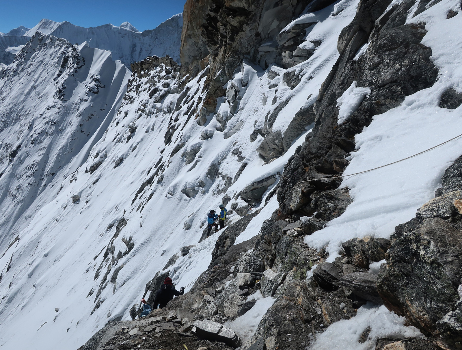
I followed Ramesh down the abseil, (which was on our new rope) just as he received the big red bag Santos carried. He secured this and I went past him to put my crampons on as they had been unnecessary up to now. From here I followed the snow ledge under the buttress for some 50 metres hardly losing height until there was a fixed rope going down for 50 metres. The anchor looked good, but it was an older rope; a bit frayed, the colours were a bit faded and it looked only 8 or 9mm and not the satisfying 11mm we had. I used it to abseil with my figure of eight but was careful not to shock it. From here the route continued down through a series of steep traverses. My crampons were very aggressive so I was slow and cautious. There were also a few stones coming through the snow which were easy to catch. It was roasting hot now, so I stopped on a more level bit to take off my harness, helmet, jacket and crampons. As I did, the others caught me up and carried on down. After about an hour since I first reached the pass I finally got to the rock where everybody was gathered.

123. Amphu Labsta Pass seen from the bottom. Our tracks can be seen coming down the centre, then skirting right under the rocks, before descending straight down again before veering right.

Again spirits were very high and everyone was a bit emotional. I thanked Dawa for getting us all over the last three passes safely and was almost overwhelmed. Bharat also admitted his emotions were overpowering. There was lots of cheering and celebrations as people ate the packed lunch Ramesh had made late last night. Most people had their boots off and looked settled in for a long and well deserved rest. The only casualties were Dawa’s sandals, which slipped off his rucksack and into the abyss as his rucksack was being lowered. It was a very happy content team at the foot of the pass in the sun filled valley. Our only task now was to walk down it for about 4-5 hours until we reached Chhukhung, where I had decreed a day off.

124. A happy team at the bottom of Amphu Labsta pass in the sunshine. It was only about 10 in the morning and we had an easy 4-5 hour descent to Chhukhung ahead of us to reach the luxuries of the Everest Region.

The four porters were eager to head off and they all crouched down and put on their head bands where they lifted their loads. They set off first, me second, and Dawa and Bharat ambled down after me chatting. It was a beautiful moraine top walk with the moraine covered glacier on one side and a quiet valley with old vegetation on the other before the hillside rose up into mountains. Island Peak was soon consumed by mist but the huge glacial devastation continued to make me feel insignificant. Especially powerful was the glacial lake of Imja Tsho which was about 2km long and hemmed in on all side by a moraine wall. I had heard about the lake before, as it was a danger for those living down the valley when the moraine wall collapses.

I entered a small quiet sandy side valley and saw all the porters flaked out on the soft vegetation out of the wind. They were just waking from a snooze. They told me how comfortable it was but I knew it was like the sirens and once I lay down I would be seduced by the comfort. Within five minutes I was asleep, only to be disturbed ten minutes later by Dawa and Bharat falling for the charms of the warm hollow. I think we all slept on the earth for a good hour. I was reluctant to get up and move off but the others were abandoning me having rested their fill.

The remaining 5-6 km to Chhukhung was a bit of a trudge. I just wanted to get there. I overtook the other while they had a biscuit break and plodded on down the dull valley. The only redeeming feature was the ramparts and misty ridges of Ama Dablam which completely dominated the south side. Its fluted ridges heavy with snow were playing with the winds up there and causing spirals and jets of mist and the moist air was forced into streams of condensation.

I reached Chhuckhung and went to the Sunrise Lodge as I think I had stayed there 12 years earlier and liked it, and Bharat and Dawa mentioned it.  It was easy to find and still looked cosy compared to the larger resorts which had been built at the bottom of the village, one of which looked like a prison.  I went for a meal while the others arrived. When they did they confirmed I should stay here and told me they had found a bhatti to hire. It was simple but it would do them for two nights. I went for a sleep in the afternoon at the end of which all six of the team piled into my room for a chat.  It seemed Dawa wanted to come with me round the Three Passes of Everest route I wanted to do next week while the others wanted to go to Namche Bazar and Thame and wait the three or so days for us to turn up. In the evening I managed to log in and delete most of the 500 or so emails waiting for me after 43 days. I managed a few more office chores, uploaded photos and went to bed dirty. It had been over a month since I last had a wash and that would be tomorrow’s luxury. I also managed to speak to Fiona on WhatsApp who had been worried about me wandering in the terrain which Google Maps showed from my tracker.

28 April. Chhukhung Rest Day. 0km. 0hours. 0m up. 0m down. Today was purely a day to recharge and catch up. Ramesh as always did my laundry, the sleeping bags were dried off, the tents where put up to dry and I spent 10 hours on my phone typing in the warm dining room of the lodge with the sun flooding onto my back. I also had the long awaited shower and managed to hack five weeks of growth from my chin. It was all done by 1900 after which I could relax and repack for the next section, Section 05. Everest Region, with Dawa with a lightweight rucksack and comfortable teahouses.

Section 04. Makalu. had been absolutely stunning and the highlight so far. I was expecting the worst with deep snow and foul weather except in the early morning but we must have moved into a different weather region as there was hardly any snow lying below 5000m and at last the long awaited stable Spring weather seemed to have arrived. The thunderstorms and thigh deep snow of Section 03. Arun Nadi Valley were long forgotten. However along with the stunning scenery, challenging passes around 6000m, and good weather, what really made this section stand out was the team. Bharat has pooled together some of the nicest, toughest characters Nepal has to offer and his quiet charm has not only kept the ship afloat but absolutely buoyant. Without them I am nothing.

Section 04. Makalu.  87Km. 44 hours.  4160m up.  3070m down.     

Back

07 April. Sumba Lumba East Pass to Sumba Lumba West Pass.  2 km. 4 hours. 150m up. 100m down. After a night of heavy snow with nearly 25cm falling we were surprised to open the tent at 0600 to find a beautiful dawn. Ramesh was the first up as usual, and went outside to fire up the primus stove to melt snow and boil water for teas, breakfast and for the day. We all followed, with Dale and me being the last. They all had Tsampa for breakfast but I have never been able to like it so had a couple of packets of noodles. It was now obvious where the East Pass was, and it was just some 5-600 metres away and up slightly. We packed up slowly and did not set off until 0900, by which time clouds were beginning to obscure all the peaks in the Kanchenjunga massif, and indeed all those intervening ones, and mist was forming on the peaks around us.

048. Leaving our camp before West Pass Lumba Sumba and climbing to the pass with Kanchenjunga in the distance.

We set off through the deep new snow with Bharat in the front ploughing like a Canadian train. It only took some 20 minutes to reach the East Pass and Dale found the prayer flags buried under snow. By this time the weather had deteriorated sufficiently to obscure all the surrounding peaks and there were some snowflakes in the air. There was a brief discussion and Dale said he had to return from here as he had a long way to go back alone and was worried about conditions. He gave good instructions to the others in Nepali and I understood some, most through the gestures. He said we should reach the slightly higher West Pass in a hour at the most. I paid him and gave him a small tip. He then said his goodbyes to all and said he had really enjoyed the last three days company. Dale had had a very hard life in Olangchun Gola, including the suicide of his mother and a violent, now-estranged father, and although 23, was guided by Nima Chettin of Lhonak’s big hearted sister and husband Tashi.

We set off and went about half a km when the snow started falling heavily and the mist enveloped us. We pushed on gingerly as it was on a steeper slope we were traversing. At one point Bharat and Ramesh went on ahead to check out a rocky slope we had to pass. They were gone 29 minutes and Santos and I were getting cold and decided to follow them as we could see them. At that point the skies cleared for five minutes and Santos and I could see the West Pass but due to the spur Bharat and Ramesh could not. I made new steps to reach them with my rucksack and told them I had seen the pass and was going on. They returned to get their packs, and by the time they had reached the spur I had already reached the last section and could see the pass. I waited a good 20 minutes for them to arrive and was cold.

While they rested I set off to where I had seen the West Pass. First down a moraine ridge and then across and up a small valley to a large cairn. By now it was snowing very heavily, the wind was getting up and it was a near white out. I could not see them following me so returned on my steps and found them slowly following and sheltering behind a boulder. I explained where I had been and we returned across the small valley to the cairn. The wind in the small valley was much milder than elsewhere. When we got to the cairn we could not work anything out in the blizzard and whiteout. I saw a cornice nearby and threw a snowball to work out the slope. There was a two metre drop. We all had a quick discussion and thought it was best to return to the small valley two minutes back and set up the tent. As it was just midday we could see if it cleared.

We had the tent up in 10 minutes and all the foam mats laid out inside. It did not relent outside and it was pointless to leave the tent. To make matters more difficult the sun was warming the tent through the mist which must have been quite thin. By mid-afternoon we decided to abandon the chance of going over the East Pass and decided to stay put, firm up the tent pegs, and melt water. Inside the tent it was well above freezing but that soon changed after 1700, and by 1900 it was perhaps minus 10. We all got into our sleeping bags hoping the snow would ease so we did not have to clear the tent and hoping that the wind would not increase to gale or storm force. It was a cold night and I did not sleep so well but the others did.

08 April. Sumba Lumba West Pass to Thudam. 19 km. 6 hours. 60m up. 1570m down. I got up at about 0300 to go to the toilet and noticed how bitterly cold it was in the wind but also how I could see the stars. By 0600 I looked again and it was a perfect day. I mentioned it to Ramesh who was beside me, and he jumped up and got into gear getting the stove going. The others followed quickly. Everything was frozen solid and even the boot laces took some working to lace up on the boots, which were all frozen solid. We had quick tea and biscuits and then then packed up just as the sun hit the campsite. It did not help and was still minus 10 at least. It took 10 minutes to set off, plough down the easy cornice, which was more of a drift in the clear weather and reach the West Pass at 5160m. The wind was bitterly cold so there was just time for a few photos, hugs, then a quick descent down the west side.

049. On top of West Pass Lumba Sumba, about 5200m, with the valley down to Thudam behind. From left Ramesh, Bharat and Santos.

As soon as we were off the crest the wind eased and after just 10 minutes ploughing down through soft fresh snow on a firm base we were in a partial suntrap. We could not relax and admire the surroundings which were huge, with 6000m mountains surrounding us. Dale’s instructions for the descent were perfect, and we followed a series of small moraine ridges down for an hour until we reached a snow covered meadow or Kharka. My gaiters had long given up and I was dreading cold feet, but Santos fitted me out with a couple of plastic bags to put round my socks and inside my shoes and my feet were perfect, warm and dry. It was a very photogenic descent and I fell behind the others taking photos. We met at the Kharka for a bar of chocolate each and decided to carry on down through the soft dry snow on the hard base while the going was good. Memories of wading down through soft sugar snow in Nanga La just a week ago were still fresh.

050. Descending West Pass Lumba Sumba towards Thudam with Santos with his huge red bag at the rear.

We went on down in the sunshine across boulder fields, rhododendron groves and occasional meadows for another good hour all on firm snow until we reached another meadow at the confluence of two valleys just at the top of the juniper trees. It was at a place called Samne. The others had already started a fire and were starting to cook spaghetti. It was a lovely meadow, and at the lower end of it I could hear yak bells clunking as they munched on the emerging grass.  Despite the huge effort Ramesh and Santos had already put in they were busy washing dishes, making tea, collecting firewood and cooking. It is quite remarkable how strong these two are. I noticed a couple of eagles, probably Golden Eagles, flying up and down the valley.

After lunch I set off first for the final 3-4 km descent to Thudam. I passed the herds of grazing yaks cautiously at the bottom of the meadow. There must have been about 50 of them and a very hardy looking Sherpa herdsman. After that I plunged into the flavoursome forest, full of smells and sounds. The river tumbled down beside me and the smell of resin from the various conifers filled the air.  I passed a few more pastures as continued the descent on a now good path. After four nights camping on the snow, often in bitterly cold conditions above 4500m, it was a delight to be coming home to the forest again. Eventually I rounded ridge and far below lay some large pastures which I guessed were the pastures around Thudham.

051. Approaching Thudam which lies in a mountain meadow after 1700 metres descent.

About half an hour later I reached the remote Shangri-La of Thudam. It was more of a hamlet with about 30 houses than a village. I spoke to a few elderly people outside some of the first houses I came to, but realized they probably did not speak Nepali, but a Sherpa of Bhote language. The houses were much smaller than the large timber edifices of Ghunsa or Olangchun Gola but of a similar style, and they all had shingles for roofs. It was as if I had walked into a medieval hamlet. I noticed that nearly everybody here was also above 50. All the young must have emigrated to find work in the lowlands, Kathmandu or the Middle East.

Thudam seemed to centre around Yak herding.  Its 15 odd houses were all built on the north side of the large meadow at the confluence of two valleys. A stream from each valley merged to form a small river which flowed through the centre of the meadow. There were a couple of traditional stone and log cantilever bridges spanning the river, but the 200 or so yaks grazing just waded the river if they though the grass was greener on the other side. I gleaned that there were about six families who herded yaks here. After we washed clothes, thawed and dried the tent I had a snooze outside our homestay. I noticed then that a lot of yaks were being driven into groups by some of the residents. They were then all forced from the south pasture over to the north for the night. The bells, some brass, and it seemed some wooden, made quite a din as they all processed past me. Most seemed to be females, called nyaks, or calves.

052. The tiny and very very remote hamlet of Thudam consists of about 12 houses or families of which 5 earn their living from yak herding.

I went into the homestay when the sun lost its heating effect around 1600. It was just one room with a Sherpa lady running it with her four year old granddaughter. She had a rustic shop full of Chinese food. Indeed everything in Thudam was Chinese as the border was much easier to get to that the road end at Num in Nepal some five days away. Santos bought, killed, prepared, and cooked a chicken for the others who had worked hard for the last five days. I slept on the only bed while everyone else, including the host, slept around the fire in the Sherpa kitchen part of the room.

April 09. Thudam to Arun River. 22km 10hours. 850m up 2480m down. We were all surprised when we woke up to see Thudam covered in 5cm of snow. All the imperfections had been covered up and what showed were the rustic houses, the strings of prayer flays covering them and the yaks starting to cross the river. Smoke hung over the houses where it leaked out of their roofs from the dark kitchens inside. After breakfast we set off about 0800 by which time some of the snow was melting. We wove through the houses and the groups of small nyaks and yaks gathered around them, passively looking at us, and headed up the track. The boys were slightly ahead of me as I lingered to take photos.

054. Overnight there was about 5cm snow at Thudam. The yaks stayed close to or under the houses at night.

After about five minutes, as the track was passing through thorny scrub, I noticed a yak up ahead on the trail round a corner. A few seconds later it was round the corner, head down, charging towards me. It was a huge angry bull and while its half ton would have sent me flying, it was the horns which loomed large. If they touched me they would have punctured me, piercing a lung or disembowelling me. I instinctively leapt off the trail, down a 45 degree slope into the thorns, and landed on some stones losing my footing and crashing to the ground cutting my knee. As I lay there I heard the hooves of the beast thundering past on the rocky path as it headed down. It was a lucky escape. It took me a good 30 seconds to make sure the beast was gone and haul myself back onto the track, scratched and muddy. Bharat and Ramesh were rushing down the track to see my fate. The beast had come out of the scrub behind them but had charged at Santos who was coming up the track. He managed to evade it by leaping onto a rock like a matador as it charged past him to spot me. We were all a bit shaken.

055. A hillside of Himalayan Primroses which thrive around the 3000m mark.

After that incident all I could think about was the yak attack as we wondered down through mossy woods into a deepening valley for a good hour. The rhododendrons were now coming into full flower and I noticed that there were a lot of pink ones also on the trees, with larger leaves and a brown underside. There were also areas where the whole green mossy forest floor was covered in the purple primroses. It was drizzling a bit now which took the beauty off the place. After about 90 minutes we reached a junction and realized the lower track was just a herding track and we had to take the upper track to escape the upcoming gorge into which the tumbling stream was about to enter. It was a steep climb up the side of the valley for half an hour until we got to another junction. The upper way looked well used, but we concluded it went over to Tibet and all the litter seemed to indicate that. The lower path seemed to be the path we had to take according to the map, but it was small and barely used. We took the chance and followed it.

For the next two hours we followed this small precipitous path through a Tolkienesque landscape of rock towers, jagged ridges, deep gullies and huge buttresses through which the path wove. It could have been the home of a Taoist Monk in ancient China. I was enthralled by the landscape but the others found the convoluted ups and downs tiresome. Eventually after some two hours I at last spotted some prayer flags between two rock towers and knew we were soon at the top. When I reached it I saw a totally different landscape on the other side. It was more grazed and covered in bamboos and the primeval rhododendron and conifer forest was gone. You could even see villages the other side of where I assumed the Arun River to be. I waited for the others.

056. The mountainsides between Thudam and the Kharka reminded me of a Chinese watercolour of the mystical Celestial Mountains.

There was a Yak Kharka after the pass but it took a good two hours to get there as the path wove all over the hillside. Frequently we thought we were on the wrong path as it descended down to the gorge. After having us puzzled, it at last started heading west contouring across the hillside. There were frequent rivulets to cross and at each on the path dropped into the ravine and then climbed out of the ravine on the other side to reach the ridge to start the whole process again. The ravines were lush and verdant and fill with mossy hemlocks and bamboos. It was perfect Red Panda territory but we did not see any signs, just a large Yak who was reluctant to move off the steep trail. Given this morning’s incident we were reluctant to approach, and threw stones and shouted from a distance until it shuffled off into the undergrowth.

At last, after six hours without a break, we reached the Yak Kharka. It was a very simple bamboo shelter with a family staying there. They had about 50 yak/cow crosses called dhzo. There were young calves everywhere, and even as we chatted the son arrived carrying a new born with a concerned cow in hot pursuit. We went into their shelter for a much needed meal. I had noodles while the others had tsampa and hot fresh milk. I had a glass of milk too which was hot and sweet. We could have lingered here but we still had three hours to walk to the bhatti at the Arun river and it was already 1530. So we bought some dried milk products called Churpi, which a hard dry product about the size of a large ivory dice. When put in your mouth it takes a good five minutes to soften slightly and then becomes chewable for half an hour before finally becoming digestible.

057. After a quick break at this Kharka which herded dhzo, (half yak half cow) we continued our journey to the Arun Nadi River.

The final stage was long. We descended from the Yak Kharka to another unused one. On the way through the forest were passed groups of magnolia trees. High above the forest canopy these trees shone. On the forest floor large white petals rested on the mounds of green mossy. It was quite a sight, but the trees were difficult to photograph against the cloudy sky. In this area the Rhododendrons were also in flower giving the forest an enchanted atmosphere above the ever present bamboos. There was a 2-300 metre climb over the last ridge after the second and disused Yak Charka before we reached a crest and could begin the descent.

And what a descent it was. On top of the previous 1500m descent we had done we not started a straight 1000m steep descent all the way down to the Arun river. Initially I felt sprightly but as the zig-zags continued my legs started to feel wooden and I lost all interest in my surroundings or sounds of birds as they prepared for the night. Dusk was coming as we reached the final bends to the very long foot suspension bridge over the raging Arun River, which flows into Nepal from Tibet. Just after the bridge was a small bhatti where someone in the Yak Charka had phoned to say we were en route and to await us.

058. The huge Arun Nadi River rises in Tibet and flows south through the Himalayas in a deep valley.

I arrived at last light and was delighted with the place. Bharat and Ramesh were already there. It reminded me of some long gone jungle shanty from a colonial era. It was a spacious woven bamboo shelter with a plank floor and a fire in the corner. It was new as the fire had not blackened any of the roof yet. It was run by a 54 year old Sherpa lady and her somewhat vain spoilt son. She was a delight with an infectious smile and laugh. We were all tired and I could not write the blog. Instead I got two beers for everyone while Ramesh and Santos took over the kitchen and made the meal. The two beers each turned into four. We all then unrolled out bedding in a corner of the place next to the bamboo walls. We had now come down to 1900m and it felt warm down here, especially after our near 10 days in the snows. The one thing I thought as I fell asleep was just how remote Thudam was, as we had walked 10 hours and still not reached the next village.

059. The tiny bamboo “hotel” in a clearing just above the Arun Nadi river was run by this charming Sherpa lady. Ramesh has already taken over her kitchen!

10 April. Arun Nadi River to Hongon. 17km  7 hours. 1200m up. 730m down. I was far too tired to do any writing yesterday, so I got up at 0630 to write and then have breakfast. The guys were quite thankful of the slow morning and used the back hosepipe which ran down the sunny hillside to wash in warmish water. We eventually set off at about 0930 after saying goodbyes to the gentle happy Sherpa lady who hosted us.

Initially it was a steep climb up the hillside for 3-400 meters to reach the village of Chyamtang. As I climbed I noticed more and more of the Bhutan Pine was dominating the trees at this altitude. The village of Chyamtang did not enchant me, and it seemed everything here was perfunctory and nothing was in good repair. The main path through the village was soggy as a black plastic water pipe had ruptured and no one had repaired it. The school, sponsored by Austria, looked like it was permanently closed save for the volleyball pitch. I was ahead of the others so I made my own way through the village and up to a defunct road which was came down from China to reach out to these border villages. The road was blocked as various places by landslides.

060. The village of Chyamtang is the nearest neighbour to Thudam but is some 10 hours walk away. It has a character more familiar with the Hill Region, or Pahad.

As I walked the breeze got up and I could hear it flowing through the pines gently swishing like a Basho poem. I passed a couple of mani walls and small chortens and then followed the pines down to the village of Lingham. I cared for it less than Chyamtang which at least had a rural feel. Lingham on the other hand was something of a commercial hub with a couple of rustic hotels and a few shops selling simple wares. There were a lot of single men hanging around these shops and hotels and even at midday some were drinking. I saw one man, all his front teeth missing and one hand in a filthy bandage,  staggering up the path already drunk on Raksi.

We had a meal here and then I escaped down the track to the nearly adjacent village of Chepwa. Chepwa was surrounded by green verdant fields of corn and potatoes. It looked like it had some rural charm but the fields were deserted and most houses were quiet. I did not go down into the centre but skirted round the top of it heading for a cluster of mani stones and chortens on the ridge. At the uppermost one the path split. With a smaller path heading up to pastures and just used by animals while the lower path seemed to be the main path to Hongon. I took it rounded a corner and got a sensational view of my route.

061. The path between Chyamtang and Hongon went along the north wall of the Arun Nadi gorge but about 500m above the river. You can just make the path out contouring across the very steep hillside.

It seemed to cling to the hillside and contour round a near vertical mountain for about 3-4 km. Far below was the roaring torrent of the Arun Nadi river in a very deep gorge. On the east side was an isolated village surrounded by valley after valley of near inaccessible prime jungle, where there were no paths and no one could venture. I started on the path across the very steep hillside. Although the Arun Nadi river was some 5-600 metres below me I felt if I threw a rock it might land in the river. I gingerly made my way down some very steep slopes until the path started to soften. At times there were even some trees between me and the precipitous slope. This made me more confident and I could walk with more abandon. These comfortable sections would be interspersed with more exposed sections where in Europe they would be secured with cables. It was a great walk with sensational views over the Arun Nadi valley towards the village of Hattiya.

At the end of this section was the small, desperately poor hamlet of Gimbar. Here it seemed a small herding community was just trying to establish itself on poor pastures on an isolated ridge. There were perhaps three or four families here on the margins of society. Perhaps these families were from Hongon and this was a summer pasture, if not it was a very poor community. I passed through and then started a long descent through forest and jungle to the river. This forest was full of birdsong and was a natural oasis in an otherwise pastoral world.

At the river there was a small wooden bridge before the long 300 metre climb up to Hongon which I had seen for the last two hours as I came along the sensational airy path. The climb was steep initially but as it climbed out of the forest and entered the first fields it eased. The fields below the village were alive with activity in the late afternoon. People were carrying baskets of organic fertilizer, carrying firewood, tilling fields with mattocks, or looking after small cattle. It was in total contrast to the commercial sloth of Lingham four hours earlier. As I approached the village hordes of lively confident children ran down to meet me without the usual request for sweets or pens. Even before I got to the village I liked it. Then suddenly I climbed a small knoll and it was there before me. Solid stone houses, most with corrugated iron roofs were spread out across a shelf. The houses were close together but were not crammed together and there were spacious lanes between them.

062. A warm welcome to the very friendly village of Hongon by some of the children. This large, charming, village had about 100 houses or families.

I was told Tengba Sherpa did homestays and asked for his place. When I arrived I found it was a simple rustic hotel with a shop underneath. It was called the Yangma Hotel. I was shown a simple room with old sheets and it suited me perfectly. They had a room for the others also. The host and his wife were very jolly and seemed to be having fun with Ramesh, Bharat and Santos who were a very sociable and easy going trio who put everyone at ease. The host was also the local teacher and in the other room were a couple of French volunteers who were working at the school for two weeks. We all gathered in the kitchen for the evening and it was an informative and social evening. There was also electricity here and so it was the last chance to top up the batteries before reaching the Everest region in about two weeks.

April 11. Hongon to Bakim Kharka. 8 km. 4 hours. 790m up. 90m down. After a superb stay at the Temba Sherpa’s lodge, where he and his wife entertained us with their wit and charm it was time to head on up. We just had a short day so we decided on a later start after eating the 1000am dalbhat. Nepalis generally just have a mug of tea for breakfast and then two Dalbhats a day – one around 1000 and one at 1900 in the evening. It is a simple healthy diet and a much revered national dish. We eventually left at 1100 in the hot sunshine. Again I noticed how busy everybody in Hongon was. School was off, so all the children were dispatched to collect pre-cut firewood in their baskets. They did this with good cheer despite it being almost an hour’s walk. In the fields everybody was busy weeding and repairing walls and fences. I walked with a couple of teenagers who wanted to practice their English on their way to get wood. When I asked them their caste, expecting them to say Sherpa they said Bhote. This surprised me as Bhote is also Tibetan type, but it is also used as an insult against the more Tibetan peoples who live in the mountains like the Sherpa.

We followed the very well-constructed pipeline taking water down to the small hydroplant which supplied the village with modest power. At the top the path headed off into the thick forest on a small and at times barely discernible path. It dropped down to a stream and crossed it before reaching another stream which it by and large followed for the next three hours. It went through dense moist forest with many rhododendrons, most in flower now, and also a band of magnolia trees around 2600m, which were all in full blossom in magnificent displays. The forest was really dominated though by some huge Hemlocks. These towered some 40 metres and a few had a bole diameter of more than two metres with at least one at three metres. I estimated this venerable old conifer to be at least 400 years old.

It was hard to follow the path in places, but it generally kept to the east bank of the stream as it slowly clawed its way up the green moist moss clad valley. There were mostly red rhododendrons in flower, the Laligras, or national flower, but there were also some pink ones with big leaves and rouge on the underside and another I had not seen before which were deep purple flowers and small almost round leaves. We reached a meadow with a great campspot but we knew there were three meadows and wanted the highest one. At the second one a group of porters came down the valley. Then even more, a couple of cooks, and finally a guide and four Belgians.

They had wanted to go to Molan Pokari but had been thwarted by the snow. This was not good news as there were 16 Nepalis and four Belgians and if the 20 of them could not force a path I thought what hope have we got. They blamed it on the thunderstorms 10 days ago and said many of the mountain areas of Nepal were badly affected, with the Government ordering people to come down. It all sounded a bit melodramatic and I hoped they were exaggerating. After all we had been coming over the Nanga La and Lumba Sumba passes during this time. The guide seemed to suggest we should turn back, but Bharat also seemed to think they had failed and so thought it was impossible for anyone else to succeed.

Just beyond our meeting with this group we came to the top meadow. It was small and riddled with boulders across its top half. None the less we managed to find a camp spot for the large tent. Bharat went off to start a campfire with we put the tent up and had it finished as Baharat’s fire got going. It did cloud over, but in the late afternoon it cleared up a bit and I could see the tracks of the Belgians and their entourage across a snowfield high up the valley side. It would be useful tomorrow but it only went half way.

Ramesh made a great dalbhat on then campfire as I retreated inside the tent to write. I am a little worried about the snow tomorrow as we must climb 1200 metres and descent 600 metres. It is my bad luck this had been such a snowy year and in my bid to beat most of the monsoon I started perhaps a month earlier than I should have done. But we have made it this far and the team is getting stronger.

063. The meadow in which we camped with rhododendron and Bhunia daphne. Beyond in the steep snowfield we had to climb to reach Molan Pokhari.

April 12. Bakim Kharka to Molan Pokari Pass. 8 km. 10 hours. 1170m up. 100m down. It was a great morning in the meadow, and the rhododendrons seemed to have blossomed more during the night. More importantly though the weather was good and I was keen to get going, so at 0530 I gave Ramesh as nudge. He was really my right hand-man; very dependable, always cheerful and a leader yet to find a role. We had breakfast and had the tent packed by 0700 and set off. I was keen to use the early morning firmness of the snow to follow the Belgian team’s footprints up the hillside as far as possible.

I set a good pace and the others were soon behind. The snow was firm and I was able to take steps with the nervous worry I would plunge through to my thigh. I followed their tracks up through the last of the forest at around 3400 and then onto a huge snowfield on the east side of the valley on a west facing ridge. Being west facing it did not get the early sun and I was delighted when their footprints stayed firm. I could see the others far below me but I was on a mission to reach the end of their footprints before the sun made them soft. The snowfield was quite steep in places and had the snow outside of the footprints been as hard as them then a slip without ice axe would have been serious as one would have crashed into rhododendron trees far below. At one stage their footprints crossed a shallow couloir which ended far down in the valley. I was slightly nervous crossing it and even more nervous for Santos who was far behind. If he lost his load it would slide and cartwheel into the depths of the valley we were climbing out of.

064. Ramesh climbing the steep snowfield with about 35kg in his basket. An awesome guy.

At about 3600m the inevitable happened and the footsteps stopped, as I knew they turned back. It was a shame for them as they had done the bulk of the climb and from here things eased off. I don’t think I would have been able to make it this far on my own without their footsteps. I now had to climb another 150 metres in the sugary snow on my own and it was very taxing. At last I reached a lip and the ground levelled off and I found a rock with some dryish vegetation on it and waited for the others. The great weather had gone and bands of mist swept up the valley obscuring nearly everything and then there was an interval when the sun returned and warmed my cold feet. After a good half hour the others arrived and we all agreed that was as steep as we would like it.

From my rock we all went up the final 100m to Molan Pokari lake. It was completely frozen over and the whole basin was covered in deep snow. It was a bit of a waste for us to see it in this winter state and I am sure in the summer it would be serene. There was a small slither of water where the stream left the lake and before it plunged over a waterfall into the valley we had just climbed out of, and there was a duck already there laying claim to its summer territory. I think it was a Brahmin Duck. We gingerly crossed a frozen part of the outflow and had another rest. The weather seemed stable despite clouds below us in the valleys to the south. I pointed out the pass only some 250 metres above us and we all decided to go for it and continue down the other side to Tin Pokari lakes.

065. The fabled lake at Molan Pokhari was completely lost in the winter landscape and frozen over. In the distance at the mountains on the Nepal-Tibet border.

Those 250 vertical metres across the snowy mountainside were very taxing. Again I led slowly, postholing my way up the snowfields of deep sugary snow which had been warmed by the sun. My progress was very slow and it was very laborious, but when I looked behind at Santos and Ramesh my heart bled for them as they struggled with their huge loads. They were so stoic in their determination to reach the pass. It took me about two hours to break a trail up the 250 meters over a long kilometre but at last having been up to my waist many times and up to my neck once I made the pass. When the other arrived I felt I had to apologise to them for putting them through this.

We descended some 50 metres on the other side and after 10 hours on the move I thought we had to camp. The descent from this pass involved just one more small climb before we could make the long descent past Tin Pokari lake, which would also be completely frozen, and then on down to Dhungee Kharka. It was after 1700 and it would soon be getting cold. There were some great views down the valley but we were too focused on getting the tent up to bother with them. While I crawled into my sleeping bag to write and warm up, Ramesh and Santos merely changed socks and then set about melting snow for tea and to cook the evening Dalbaht.  There was no rest for them and without them I would have no hope of having completed what we had done. They were the real heroes of this trip.

April 13. Molan Pokari Pass to Dhungee Khola camp. 15 km. 7.5 hours. 160m up. 1190m down. The first thing we had to do today was climb a slight ridge to gain the valley with the Tin Pokari lakes. The weather was on our side although there had been thunderstorms nearby during the night and we had had about 5cm of new wet snow. Bharat led the small traverse and climb across and over the ridge and then seemed to hesitate on the huge downhill section coming up so I took over.I tried to keep to the slopes where I thought the sun would have least effect but it was impossible to link them all up and occasionally I was up to my waist. I thought of the poor porters. Despite the magnificent surroundings I was angry with this year’s snowfall and despondent about the task ahead even for the next four to five days to Yangri Kharka where we would meet Dawa. We just seemed to be wading or ploughing huge amounts of snow where there should be the odd snowfield and otherwise small paths. I was not enjoying it, and there just seemed to be no end in sight.

The descent down to Tin Pokhari was ok as I seemed to hit a seam where I only went in to my ankles as I ploughed down. The others seemed reluctant to follow, and I suspect Bharat was waiting to see how I got on. When I reached the lakes I did not stop but continued down the north side of the river on a ridge of firmer snow. As I reached the valley I veered away from and bushes or boulders which might mean softer snow. Before me was the large meadow of Dhungee Kharka, which was completely covered in snow. My descent fortuitously led to two simple log bridge over the infant Dhungee Khola stream. I continued down the snow covered meadow occasionally looking round to see the other following perhaps a km behind. At the bottom of the meadow were some grassy hummocks partially in the sun when it broke through the mist. I waited here for the others who arrived remarkably quickly.

066. Coming down from the highpoint near Molan Pokhari to Dhungee Kharka.

Below the snow covered meadows the route descended to the west of the stream. However it was all covered in snow as it weaved its way through rhododendrons and bamboo thickets. Somehow I managed to pick up the hidden path and followed it down for a good hour until the snow finally disappeared at around 3200m. Occasionally I took a wrong turn and had to back track just as the others reached the same fictitious junction. Because the path was so elevated in the snow the porters had real difficulty negotiating the tangle of boughs and branches which would otherwise be a metre or so above them. Once the snow had gone we picked up speed and enjoyed the utter wilderness of the valley into which very few venture.

I rounded a corner and started heading up the Kholakharka Khola on the rocky path. After half an hour I thought something was wrong as we were climbing. I though this tiny obscure rough path is leading us up the valley to a pass into Tibet. The others agreed and then Bharat and Ramesh volunteered to go on without the baggage to check it out. They came back 20 minutes later to say it was heading up the valley and not down to the stream. We must have missed the path down to the bridge on the map. Bugger! We had to back track for a good 20-30 minutes to where we assumed the other faint path might branch off.

After five minutes we all thought it might be just as easy to bushwhack down the steep hillside to the confluence of the Dhungee and Kholakharka streams, and hopefully we would intercept the path we missed. The bushwhack was arduous for me, and to make matters worse it was raining now. The hillside was steep, slippery and covered in a creeping weed which obscured boulders. I often used bamboos or rhododendron branches to stop myself falling. It was very difficult for me but poor Santos frequently got ensnared in the weed or slipped on the steep muddy slope and fell a total of five times. Even Ramesh was struggling, especially in the thickets where his basket frequently got caught. I made it to the confluence of the streams first and found no other path we missed. To my horror there was also no bridge over the stream. It would have been easy enough to wade but it would have been thigh deep and white water. I wandered upstream a bit and found a simple log someone had placed. Eventually the others followed me up and we all crossed.

067. Ramesh crossing the tiny bridge over the very remote Saldim Khola before we headed up the south side.

From the log we had to bushwhack again through wet rhododendrons hoping to find the path. It was already 1630 and we were all concerned we might not find a camp spot. At last I spotted a path coming down the valley and pushed through the scrub to it. We all let out yelps of delight when we came upon it. Following it down for about 15 minutes we emerged from the silver fir and scrub forest onto a small meadow which had a great campspot. As usual now Ramesh and I put the tent up while Bharat and Santos went off to start a campfire to dry some clothes on and cook on. We were all wet, muddy and miserable but somehow the porters kept up their good spirits. Tomorrow should be a short day to a cave camp but after that we have another three difficult snowy days around the 4000m mark. It is imperative we do this otherwise we might be trapped as I don’t think it is possible to follow the river down and the only other way out is back the way we came via Molan Pokhari. I told Ramesh the cook and quarter master we might need another five days of food and he looked concerned! This section is turning out to be an extreme boot camp.

068. Whenever we camp in the woods we make a camp fire to cook on and to dry out some clothing.

April 14. Dhungee Khola Camp to Sedim Khola Cave Camp  5km. 4 hours. 400m up. 300m down. It seemed another nice morning but we only had some 5km to go until we reached the the so called cave camp in Sedim Khola at the bottom of a 1100m couloir. The guys lit the fire again at the bottom of the meadow to make breakfast. The whole meadow seemed to have been ravaged by wild pigs. This was an extremely remote area and I am sure they seldom had to worry about humans. We set off about 0800 and followed the small path down the west side of the Dhungee Khola stream.

After about a km we suddenly reached a large and quite new bridge crossing to the east side. It was not marked on the map. I was quite sure we should not cross it but Bharat and Ramesh went off to investigate and returned saying there was a small path. In the meantime I investigated the path heading south down the west side, as the map indicted and it seemed to be ok. There was a bit of a discussion about which path to take, but as I was the only one who understood the map I prevailed. It was a total mystery where the other path went as this whole area on the map was pathless. I concluded it must go over the mountain to Hattiya, a two day (or in these snowy conditions a four day) walk away. It was possibly our escape route if the Pass from Sedim Khola was too steep or dangerous.

We continued down the Dhungee Khola for another 2km, climbing slightly through the fir, hemlock and rhododendron and then descending steeply to Sedim Khola. There was the remains of an old meadow here but it seemed the jungle was taking over again. I wondered just where people came from to bring their animals here for the summer as I cannot stress how remote it was. Just below this meadow the path met the Sedim Khola stream and crossed it on the smallest most rickety bridge which would take 100kg, which was perhaps built by the seasonal herder for his goats.

We stopped here and again Bharat and Ramesh went off to explore the path even after I told them it was in the opposite direction and we needed to go upstream. I am sure this path would have been summer herding track as the map indicated that the Sedim Khola descended into a deep gorge for some 30 km until it joined the Barun Nadi river which was also in a gorge. If in the remarkable circumstance there was a bridge over the Barun Nadi river we might be OK, otherwise we would be would be trapped after our arduous two to three day bushwhack. Our only way out was over a pass which started 2km upstream and which I had seen yesterday. From the foreshortened view it looked steep and covered in snow and I was full of dread.

We found the path up the south side of the Sedim Khola as it emerged from avalanche debris and followed its faint route up. After a km we lost it as it was frequently buried by snow. I could see the chute at the bottom of the pass about a km ahead and it was completely filled with avalanche debris. There must have been multiple avalanches down here over the last two to three months and it spilled out into a huge fan almost a km across. I was keen to look up the chute so we climbed up the hard compacted snow of the east side of the fan for at least half a km until we could look up. It was not as steep as I feared and I reckoned we could do it in a morning as long as the weather was OK. It was a 1159m climb in all.

However there was nowhere to camp here and the small cave could only sleep two in discomfort. Ramesh wanted to continue up and get to the top and camp at Kalo Pokhari but I thought it was far too late in the day. I spotted a small meadow just 100 vertical meters below on the edge of the avalanche debris and we set off for that. It only took ten minutes to get there on the hard snow which flowed right across the Sedim Khola. The meadow was a bit damp but we had no choice. The tent was up quickly and Bharat got a camp fire going.

Just as we got settled round the fire it started to rain and soon it was bucketing down. This was not the sun filled afternoon to dry the tent and make our damp claggy sleeping bags crisp which I had been hoping for. I was beginning to hate this section. I slept while the rain poured. The other played cards in the tent and told me there were frequent avalanches in the valley during the rain shower. It was a very deep valley with large 4-5000 metre mountains on each side so I could easily imagine snow avalanching from high peaks and descending on the clogged avalanche routes. It was imperative for us to have good weather for us to ascend the pass to Kalo Pokhari. From there it would be at least another night in the snow at 4200-4500 metres. It would be a difficult three days. I also felt some sort of responsibility for the others as I had led them into this predicament, which I am not sure if they fully grasp.

April 15. Sedim Khola Cave Camp to Top of Chute. 5 km. 4.5 hours. 880m up. 20m down. It was imperative we got an early start so I set my alarm for 0300. Bharat got up and got the fire going and the ever reliable Ramesh and Santos followed leaving me to empty the tent while they cooked what has become known as Sherpa stew; namely rice, lentils and anything else, in this case chunks of ginger and the last potato. We ate round the roaring fire in the dark under the stars until the first light erased all but the brightest. It was light enough to walk by 0500 but we did not set off until 0530.

Our task was not an enviable one. We had to ascend some 1200m without respite, mostly up a steep couloir. We were blessed with good crisp weather and a slight frost. We had two pairs of microspikes, and I suggested Ramesh and Santos put them on as the first 500 metres of the chute was compacted avalanche debris and very firm and with the frost it was hard. They immediately felt comfortable and left Bharat and myself behind struggling for grip. I found it easiest to follow Ramesh as he disturbed the glassy surface. Eventually the surface softened slightly and Bharat and myself could take the lead and kick steps for the porters. It took nearly two hours to climb the first 500 metres and reach the top of the chute clogged with avalanche debris. We then had to climb a small steep section to gain the upper part of the chute which was not so ravaged by avalanches coming down from steep gullies to our west.

069. Heading up the huge gully to the east end of Furling Danda ridge. The gully was clogged with avalanche debris making for a firm surface which was easy to climb.

The upper chute was basked in sunshine which was a blessing to be in, but a curse as it was softening the snow. It was always ankle deep now and sometimes even knee deep. I led the way which was hot and exhausting while the others held back. I could forgive the porters with their heaving loads but Bharat was asked to take over for a while, which became the rest of the climb as I could just not keep breaking trail. The upper chute had another climb in it and then opened up in an almost flat fan perhaps a km across and covered in blue sheep tracks I think. The views to the north were stunning and we could see right up to Dhungee Kharka and Tin Pokhari where we were a few days ago. The valley we just climbed from, The Sedim Khola, was filling with mist, but the mountain tops on the far side were proud of it.

I was concerned that the weather was playing its usual trick by being fantastic for the first three to four hours and then slowly misting over and deteriorating until there was snow in the afternoon and evening. So Bharat and I rushed to a pass at the top of the fan to see where the next and final climb was before the small descent to Kalo Pokhari at 4200m. Out of breath and with my thighs bursting, we just made it up in time to see what we thought was the next section disappearing in the mist. With the 1:100,000 Nepali map, never known for its accuracy, and a cirque of jagged mountains before us, we needed sight of where we were going in the soft taxing snow. We waited for a good half hour but realized the weather was now deteriorating for the day so we went down to a flat area and pitched the tent even though it was just 1100. The mist enveloped all in a white out and we all thought there would be no let up so I got my sleeping bag out and had a snooze while the other three played cards. I was woken by rain on the tent. There was no let up until about 1700 when the mist cleared and revealed our pass but it was too late by then.

If this weather pattern continues we will still have three days to reach Yangri Kharka where Dawa is waiting for us. There is a teahouse there and it is becoming the promised land. Just two more high altitude nights, frozen shoes in the morning and 3am starts to go before we are out of our claggy tent and into relative luxury. We will arrive like bedraggled refugees

April 16. Top of Chute Camp to half way between Kalo Pokhari and Kharka canp.  5 kn. 6.5 hours 560m up. 260m down. It was another 0300 start to try and catch the best of the weather and the firmer snow before the sun softened it. It was desperately hard to put on wet socks and frozen shoes and then grapple with the frozen tent. We eventually set off at 0500, and this time I put Bharat into the lead by telling him I was just not powerful enough to make steps today. We climbed slowly but surely up for about 200m when we stopped for a rest. Bharat was tired after a difficult spell and I took over for the last half km to the pass over to Kalo Pokhri. There were some fantastic views down the valley and even down the steep slope we had just ascended.

True to form the mist already started forming at 0800 and the sun was had already softened the snow in the east facing slopes as we climbed out of the impressive cirque of towers. The descent to Kalo Pokhari lake was generally firm but I frequently went through the crust into sugar snow underneath and bashed my shins on the hard 3cm of crust. By the time I got to the bottom of the easy gully I was into soft sugar snow again and frequently up to my knees.  Kalo Pokhari lake was a typical glacial cirque lake lying at the bottom of a deep bowl surrounded by jagged spires some 500m above it. Between the spires were the start of long snowfields which fanned out until they reached the lake, which was completely frozen.

071. A steeper section on the snow chute where a ridge of moraine cut across the main gully made for a tricky section which Santos and his huge pack gallantly led.

The weather did not deteriorate much after the early mists and it was only 0800. Yet despite this the snow was soft now. I would have been ok camping but the other were keen to move on given our food situation. I again told Bharat he would have to lead as I was just not up for it. What followed was a three hour struggle through some 2km of wet soft snow where we only climbed some 200 metre in all. Bharat was tireless in his efforts and postholed constantly to his shins and I followed usually adding some 15cm to his footsteps. Our feet were soaked as no cheap Chinese gaiter could keep that amount of wet sugary snow out. We all had plastic bags over our socks and in our shoes but the sock quickly got wet and our feet were freezing.

073. In the top half of the snow chute where it opened up into a fan leading to the penultimate pass of the climb which is all we managed before the mist arrived.

We saw some prayer flags on the shallow ridge ahead and went over to investigate them. There was a pass which went down from here but it looked extremely steep and convex just to add to the foreboding. It descended a good 150 metres. We all thought it too steep to descend safely. The map showed we should have climbed just a tad higher and then slowly descended on gentler slopes into the valley higher up where it came up. Just as we were debating what to do the mist descended and obscured all in a near white out. With our cold feet, huge effort already today and the confusing mist we decided to camp even though it was just midday. We all knew the weather was not going to improve until the evening.

We had the tent set up quickly on a level patch of snow. Then the matrasses were unfolded and we all dived in to change into our diminishing supply of dry socks. We all then climbed into our sleeping bags to try and warm out feet up, except Santos who grappled with the stove to melt some snow and boil water for soup. The rest of the day was now familiar with me snoozing and the others playing cards until it was time to cook supper around 1600. We were all done by 1800 and crawled into our sleeping bags for the 0300 alarm. This will hopefully be our last night of camping in the snow but we still have to find out way down to the valley and then climb up an over a 300m ridge before we can begin out descent from these difficult mountains where we have seen no sign of anyone else for about a week in this remote snowy wilderness.

074. Our camp just after the penultimate pass. We had to camp here around midday when mist enveloped us and confused us.

April 17. 1/2 Kalo Pokhari to Kharka to Ridge east of Kharka. 6 km. 7 hours. 530m ascent. 470m descent. There were loud thunderstorms throughout the late evening and early night and the tent lit up with a flash every 10 seconds or so. Most were south of the Barun Nadi river but some were quite close. They dumped about 5cm of sleety snow which later froze. Then the temperature dropped to about minus five and everything froze. At the 0300 alarm the tent was covered in frozen sleet. We were up and running by 0500 but as soon as the light came the stars disappeared and the mist arrived. We climbed back up to the top of the very steep gully which I was sure was too steep for us to descend and no one was very keen on the idea.

075. Leaving camp at 0500 in the morning to gain the top of the snow chute pass, our first of 3 in the Furling Danda range. Behind us the mountains of Eastern Nepal are spread out all the way to Kanchenjunga in the distance.

I convinced myself and the others that it was not the pass we were looking for but a lower one which went a different way, despite the small chorton and the prayer flags at the top of it. According to the map and my altitude meter the pass we wanted was just up the mountainside a little and there we would find a rake or sloping shelf to lead us down the craggy steep valley side to the floor. So we set off to find it. The mist was all encompassing and it was difficult to see, but with Bharat in the lead occasionally throwing snowballs to see the lie of the land we slowly progressed up the hill. We became very confused in the white out and nearly put the tent up but then the mist cleared and we could see where we were. And that was still on top of the crags which formed the side of the valley. We persevered in the wet snow, our feet getting cold, but we could just not find the rake to lead us down. Eventually Bharat and myself went on to where I was convinced it was (but we were 100m too high by now) to find another disappointment. I had to admit it my altimeter and map reading deceived me and now it was obvious the steep gully with the prayer flags was the way. It did not take us long to descend but there was tension in the air as we had wasted the best part of three hours on my excursion and needlessly climbed and descended some 150 metres.

On reaching the top of the steep gully I volunteered to go first but Bharat and Ramesh insisted they check it out without their baggage. They got to the top of the convex section and saw it was a straight run down to a fan of snow some 200m below. The warmth of the day was however melting some of the new snow from last night and this was occasionally flowing down the gully in  small avalanches. Underneath the old snow was soft and sugary. As they returned to come back up I started my descent and it seemed quite secure in their steps. We exchanged words as we passed and I carried on keeping to the side to be out of the way of any larger avalanche should it surprise me. I reckoned the gradient of the gully was about 40 degrees and it was 200 meters in height. At last I reached the fan at the bottom and veered north so as not to lose too much height as we had to climb up the other side. Relieved, I rested on a rock and watch the others emerge from the bottom of the gully and onto the fan.

076. The last part of the climb at the top of the snow chute leading to the pass over to Kalo Pokhari.

We had a few glimpses of the other side as we descended and it involved a 3-400m climb up to a shallow ill-defined pass. We knew all would be on rotten snow and to compound it the mist returned. With Bharat in the lead we followed in his footsteps. However I nearly always went deeper and occasionally up to my waist. It was exhausting work for all of us especially the porters. We again got confused in the whiteout and knowing it was not going to clear and afford us a view we decided not to flounder about any more with wet feet and call it a day. The trouble was there were no flat tent sites so we had to spend half an hour excavating a flat site from the hillside using the dinner plates as shovels. Once the site was level we all crawled in to warm up as the snow started to fall heavily. I snoozed to try and warm my feet up while the others crawled into their bags and played cards. Santos seemed to be on dinner duty and had to go out into the snow showers and cook spaghetti on the large kerosene stove. As he did there were frequent thunderclaps. It was a very frustrating day in these wild remote mountains north of the Barun Nadi river which seem to attract poor weather. Our last week has really been a miserable winter mountaineering expedition but without the benefits of good boots and gaiters to keep the snow out. Everybody has been fantastic but morale is now low and we need a break.

078. Our last of 3 campsites on the difficult Furling Danda ridge. We could not find a flat spot so had to dig a shelf out of the slope with our metal dinner plates.

April 18. Ridge east of Kharka to Yangri Kharka. 15km. 8.5hours. 410m up. 1180m down. There were again frequent thunderstorms in the night and some 10cm of new snow, but it was relatively warm in the night and it did not really start to freeze until the early morning by which time it was misty. Indeed the mist did not clear until 0500 and this prompted speedy activity in the tent to the extent I got slightly left behind putting on my cold damp socks, covering them in plastic bags and then putting on frozen shoes. We set off at 0630 and it was perfectly obvious which way to go now, and my excursion up the hill yesterday to find this pass, just before we abandoned everything and put the tent up, was hopelessly flawed. My second mistake of yesterday.

All we had to do now was traverse the ridge for about a km heading south and we would naturally come to the pass. The sun had long risen as we made our way along the ridge with Bharat leading the way. The snow was soft as it had been insulated by the morning’s frost by the 5cm of new snow which had fallen. As a result we frequently went through but in the sunshine and with the pass fast approaching it made it more bearable,  especially with great views to the east of this gnarly little ridge we had just traversed, and beyond that a sea of peaks stretching east culminating in Kanchenjunga and Jannu rising above all in the distance.

081. The joy of reaching the last pass was shared. It had been a hard 4 days to end a gruelling week since the comforts of Hongon. In the distance is the Khongma La pass on the Makalu Base Camp route.

At the pass there was a marked change in the mood of the team. The tension which had been building suddenly vanished and was replaced by euphoria as it was virtually all downhill now to Yangri Kharka. We had been out camping in the snow for eight days now and were all looking forward to a dry sleeping bag and dry feet. To cap it all there was a small view of Makalu, the 8500 metre mountain which would dominate our views for the next few days. We had a joyous photo session at the pass before starting the 500m descent to the snow-filled meadow in the valley on the west of the ridge. It was not as simple as we hoped, as the last 200m of descent were through soft snow with rhododendron scrub and we were frequently up to our waists in wet snow with our feet tangled in branches. At last we got to the stream on the valley floor, crossed it, and then started a difficult short climb through snow to a clearing where we had seen some signs of a snow covered path.

082. The steep gully we came down yesterday which was essentially the second pass in the Furling Danda range. Viewed from the third pass before the long descent to the Barun Nadi river.

Across the deep valley to the south were the snow covered ranges of the Khongma La series of passes which trekkers and expeditions to Makalu Base Camp had to cross. It was an area notorious for poor weather. In the valley was the Barun Nadi river in a deep gorge surrounded by huge cliffs and steep slopes covered in scrub. It was into this valley we now descended, but as we were on the south facing slopes the vegetation was much richer than the bleak scrub opposite. The rhododendron suddenly changed variety to the taller large leaved variety and then there were the first of the Silver Firs at around 3800m. Before long we were in the forest. The homecoming was fantastic. The smell of resins and birdsong filled the air as the big venerable trees enveloped us. There was even some warmth in the glades but much of the ground was covered in hard snow patches with icy fringes. I saw a couple of Himalayan Monals and many Blood Pheasants and other grouse type birds. They would all be very unfamiliar with humans in this remote corner of the Arun Nadi River drainage basin. The further we descended the more we left winter behind and entered a warm spring world with carpets of the purple primroses and flowering bushes of red rhododendrons. We plummeted down the spur with the air getting warmer as the roar of the Burun Nadi river got louder until we found a small glade with a small stream and a abundance of firewood and stopped here for lunch, eating the last of our food. It now became obvious we would easily reach Yangri Kharka today.

083. The rickety bridge over the Barun Nadi river took a steady nerve to cross. Here is the brave Santos having his go.

After lunch we had to walk along the tiny, tortious, and sometimes dangerous, path on the north side of the Barun Nadi River while looking across to the well-constructed path on the south side which was the main Makalu Base Camp path. We had to skirt plenty of landslide areas until after about 3km I spotted a ramshackle bridge over the torrent. It was very difficult getting to the bridge due to landslides and erosion but eventually I stood before it. It was extremely rickety and I was not sure I trusted it all at all. I went first and it seemed to hold. Bharat followed in a very cautious manner. Then Santos charged over with his huge load knocking one of the few logs into the water, much to the consternation of Ramesh who came last. There was another celebration as we now were on a major path up to Makalu Base Camp.

We immediately passed a teahouse run but a very charismatic Sherpa lady, and went in for a cup of tea. She was the first person we had seen since the Belgian group some eight days ago. She told us the ridge we had traversed along was called the Furling Danda. She also told us Dawa, our climbing Sherpa for the next high passes section, had been there this morning to try and contact Baharat’s office. He had been waiting for us Yangri Kharka now for four days while we have been stuck in the snow on Furling Danda.

The final kilometres to Yangri Kharka were glorious. The path crossed back to the north side in less than a km making our perilous bridge crossing somewhat unnecessary. For the next three to four km it wove a route beside the river across grassy meadows and sandy flats where a huge flood some three years ago had brought much silt down the valley and eroded the course of the river and  destroyed the old path on the south side. I chatted with Bharat as we sauntered along here through the silver firs with the steam rising from a short rain shower. Huge mountains rose up 3000 metres on each side of us with Tu Tse (Peak 6) soaring what seemed almost vertically on our SW to a glacier covered crest above the clouds.

084. The final steps across the meadows on the valley floor before reaching Yangri Kharka, which for us had become a promised land. Dawawas waiting here for us to take us over the high passes in the next section namely; Section 04. Makalu.

At last we reached Yangri Kharka and there was a warm welcome from Dawa who was much relieved to see us. He had arrived four days earlier with two porters and all the climbing gear and some additional gear for each of us.  He had brought my gaiters which I sorely missed in the last week along with my climbing boots, crampons, 200m of rope, snow anchors, harnesses, helmets and more. Our team of four had now become a team of seven for the next three weeks. There were some lively and joyous conversations over the next half hour before I went off to my simple room made of corrugated iron while the others caught up with each other. The next day would be a rest day to allow us to get cleaned up and dried off and to get acquainted with the climbing gear. Although Ramesh had been over Sherpani Col before, Santos and Bharat had hardly had a harness on.

Yangri Kharka was pretty much the end of the Arun Nadi section as although were still in its drainage area, the high passes south of Makalu, namely Sherpani Col, West Col and Amphu Labsta deserve a section of its own. The Arun Nadi section had been testing for us. Firstly the Lumba Sumba Pass to enter the section had been taken us longer than expected due to poor weather mostly affecting visibility and making us camp two nights at 5000m. After this, the section was varied and wonderful – especially the remote village of Thudam and mystical journey to the Arun Nadi River. Thereafter the villages to Hongon were lovely, but after that it became very taxing from Molan Pokhari all the way to Yangri Kharka. In retrospect it would have been so much easier to go from Hongon to Hattiya and then up the south side of the Barun Nadi river to Yangri Kharka, but that is not the route in the spirit of the Ghreat Himalaya Trail which is to endeavour to go the highest route possible. But given the winter conditions of the Molan Pokhari to Yangri Kharka due to the extreme snowfall this spring and the fact that this section attracts misty conditions as damp air travels up the Arun valley and condenses on these mountains, it would have been better to do the lower level alternative via Hattiya. The higher section we did should certainly be considered if there is a low snowfall year for a spring crossing, and especially if a post monsoon start to the Great Himalaya Trail is done. But for our trip with an early start in a very snowy year I am glad to see the back of it.

Section 02. Arun Nadi River. 127 km. 79 hours. 7160m up. 8490m down.

Back

16 March. Suketar to Simbu. 12 km. 4.5 hours. 300m up. 990m down. The two porters, Ramesh and Santos took the night bus from Kathmandu to Bertimod with all our baggage while Bharat and I flew to Biratnagar and took a taxi to Birtimod where we would meet around 10 and then charter a jeep for the four of us and all the baggage to take us up to Taplejung some seven hours drive away. Unfortunately a bearing broke on the overnight bus wheel and they were eight hours late. We left in our jeep as it got dark and had a hard drive for three hours past 1am to a dull pretentious hotel. The next morning the four of us got back into the jeep with the driver and drove another 4-5 hours to Taplejung and on to the nearly mothballed airport at Suketar where the road ended. We had a daltbat here to fortify us for the walk.

By the time the food was cooked at the bhatti we had packed the porters’ baskets and we ready to take our first of many million steps. After a group photo we raised out loads and headed east up the dusty track with the occasion rustic 4 wheel drive jeep, loaded to the gunwales, labouring past and blowing up dust. It was a short hike up to Deurali, which was a busy hamlet catering for pilgrims to the important Phathibhara Temple, but is now by passed by a dusty track where jeeps ferry the devout. We stopped for water here and then headed down the other side of the pass. It was largely forest on this side with some clearings far below. The road was carved into the hillside, sometimes precariously, and it made frequent hairpins. Where possible people have stamped a shortcut between the bends.

The forest was warm and humid but the haze in the air smothered the distant views beyond the next valley. It was largely dust and smoke in the air which is only in the early morning and dusk. Amongst the large tree were Rhododendrons vibrant with red flowers. However it was the grand magnolia trees which stole the show with the bright bulbous branches thick in white flowers. Much of the route was down on the track passing some homesteads until we got to the hamlet of Lalikharka. It was mooted as a place to stay but it was just 3pm and we had only walked two hours so I suggested we walk on Simbu in an hour and a half.

011. The magnificent magnolia trees stood out majestically in the forest

We went into the kitchen for a tea. I was overwhelmed with nostalgia inside. It was the genuine rural idyll inside with a neat earth stove and shelves of tin and copper utensils. Some dry meat was hanging from the rafters preserving itself in the smoke. How far removed is this from the noisy chaos of Kathmandu. it was the first time I had relaxed with the porters in a relaxed setting and I knew I would get on with both of them. Bharat has chosen well.

After the tea we continued down through clusters of homesteads circling above the pastoral village of Tembewa as we contoured across the hillside peppered with the bright red Rhododendron flowers. We then crossed a ridge and started a long descent on a rocky path. As we descended we reached homesteads in small fields now given over to cardamom, it being the new gold fever crop of the region.

With tired legs we reached the main cluster of Simbu where I found the rustic hotel I had been told about. They had a very simple room for me and space for Bharat, Santos and Ramesh on the floor. However they had a cosy kitchen and pressure cookers hissing with cooking rice and dahl. I retired to my room to write while the others hung about until it got dark and then moved into the kitchen. I could hear the buoyant barrel-chested Santos holding court. It was quite a short day but we were all glad it was over and I was delighted to be back in rural Nepal.

012. A typical homestead on the way down to Simbu. These homesteads are surrounded by cardamom plantations.

17 March. Simbu to Phumphe Danda. 18 km. 8 hours. 1160m up. 990m down. We all slept well in the cosy tea house and left after a quick breakfast at 0800. We could and should have left much earlier as it was daylight by 0600 and by 0800 it was already getting warm. We descended for almost an hour through small terraced fields and then into the humid warm jungle at the deep valley floor. We now faced the daunting prospect of a gruelling 700m climb in the hot sun. Santos and Ramesh paused frequently and Bharat stayed with them so I decided I would do the whole climb at my slow pace but without stopping before Kande Bhanjyang Pass.

013. Another homestead on the way up to Kande Bhanjyang in the middle of a hot 800m climb.

I trudged up the steps occasionally coming to a track which zig-zagged up the hillside carving a ruthless path through what was once peaceful terraced fields. The path generally short cut the zig-zags passing some homesteads and chautera which are resting places under the shade of a peepal tree. After a good hour I passed a rural village, called Hinchhebun, with a school and a few local shops. I stopped to chat in very broken Nepali to occasion people, usually men, working at their homesteads usually opening my conversation by asking directions. My smattering of 3-400 Nepali words slowly returning to me. After about three hours I finally reached the pass and found a clean local shop fun by a Gurung. I asked him to start cooking four dalbhat for me and the other three who I hoped would not stop to eat before at the usual time of 1000.

As always the meal took about 40 minutes to cook and was ready just as the others came into the hamlet. We fell upon the piles of rice, dahl and curried vegetables and cleaned out plates and then washed the meal down with tea and buffalo milk. We then relaxed and chatted with the Gurung owner for another half hour before it was time to set off again around 1300. I again went on ahead descending into a huge crescent formed by two ridges.

I descended into the bowl past homesteads sitting amongst terraced fields until the path entered jungle. The path was easier to follow here as it was less confused. It contoured across the hillside in the jungle and then climbed steep ground up to the other ridge of the bowl where there was a small temple and a chautera. I had a drink of water here waiting for the others but after 20 minutes there was no sign, so I continued through the small hamlet of Phungphung Danda contouring across the steep hillside to the village of Yanpang. Ahead of me far up the valley I could see the high peaks of the Kanchenjunga massif. At the far end of Yanpang was a small bhatti and I was making a beeline for it hoping for more buffalo milk tea to sooth my dusty throat. It was a lovely saunter through the cottages of Yanpang but the bhatti just had black tea. I waited half an hour for the other to catch up and hey looked as tired as I felt.

From the bhatti there was just an hours’ more walking slowly climbing up a ridge, initially gently and then steeply to crest another ridge. It was the final effort of a long day. From the top of the climb it was a delightful walk in the cooler late afternoon sun along a level path high above the valley floor for half an hour to the village of Phumphe Danda. Right at the start was a rustic hotel which seemed neat and tidy. There was also another English speaking group staying here so I was delighted I would have someone else to chat to that evening. Our group split that evening with the Nepalis getting together for a raucous evening in the hotel kitchen while me and the four English speakers gathered in a dining alcove for a quiet meal. I was tired but Ramesh and Santos recovered quickly – Santos so much so he chased a chicken across the hotel yard which ended up in their pot.

I chatted with the expats who were living in Thailand and I was glad of their easy company and gentle witty banter. Bharat came through with a tumble of raksi, told some stories and then disappeared. I hobbled up to bed quite early and slept quickly in the tiny room with the phone charging off a 12v battery system.

18 March. Phumphe Danda to Sherpagoan. 12 km. 6 hours. 990m up. 790m down. The morning did not start well. I was up and packed by seven, but the others had been up until late drinking and dancing. Once they were up I had some gentle words and would leave reading the riot act until later.

Again the day started with a 300 metre descent followed by a quick steep climb up to the village of Manankhe, a small Limbu village with clusters of cottages and a museum of cultural life but it was closed. I was walking with the expats and Santos now.

After leaving Mananhke we all noticed how dark the skies were becoming. This was not good news as any rain here, though unpleasant, would fall as snow higher up, and make life very difficult over any passes. Despite my 16 kg rucksack I felt quite buoyant and relieved to be out of the oppressive heat of the last 2 days. I left the others behind and walked across the steep hillside contouring in and out of steep ravines. Although I say contouring nothing in Nepal is flat and there were many short up and downs.

After in about three hours in all it was about 1100, well after Dalhbhat time and I knew Santos would be getting hungry, as were the other group with the expats so I stopped at a bhatti. The expat’s guide said it was the only place. He soon arrived and we ordered ten, six for them and four for us. It arrived an hour later and was a disappointment as the dahl was barely yellow water.

The small path continued its steep undulations until it descended to the river in the valley below by a swing bridge. We did not cross the bridge but wove through cardamom plantations on the valley floor for a glorious flat km. The sinister sky now broke with large droplets of water crashing into the dust on the path like little meteors. Just as the climb started the lightening and thunder also started which hastened my pace and I soon left the other behind. I powered up the smooth dusty boulders of the path but it became inevitable I would have to stop and cover up for the rain.

The path climbed rapidly up to Yampudin on a ridge. Below it on the valley floor in was a larger village with a big police post. Whether I needed to go there or not I don’t know but I could see the expats and their guide also bypassed it. It was now getting miserable and cold but tomorrow was a big day and it was necessary to continue up the hill for another hour to a delightful village called Sherpagoan. There were three rustic hotels here. I took shelter in one to see where the expats went.  They went to the other – it was the nicest place on the trail so far. The rain continued all evening and at the cloud level I could see the forest turning white with snowfall. It did not bode well.

19 March. Sherpagoan to Torantang. 22 km. 8.5hours. 1680m up. 810m down. The hotel was quite noisy and I woke a few times with people crashing about and when my alarm went at 0530 I dis not feel so well rested. To my dismay I heard one of the expats, Oliver shout that he needed a rest day to get over his cough. It was probably a good idea as there was 1400m of ascent in total up to the Lasiya Bhanjyang, 3310m, and it looked like the top half was covered in last nights snow.

Initially the path wove through the forest above Sherpagoan, climbing mostly, and passing a couple of herders with their tiny cattle and a few sheep. Eventually we go to a stream where two streams joined where there was a small bridge which looked like it was from a Japanese garden. This was the last water, and from here the path ascended steeply up the ridge between the streams for a relentless steep zigzagging 3-400 metres. I left the other behind here as they took frequent pauses and I trudged slowly but surely.

015. At the saddle after the huge 1000m plus climb from Yamfudin or Sherpagoan is a small cabin or bhatti which serves food.

There were glimpses through the dense dark forest but I was mostly looking at the hillside. There were bamboos about on the forest floor and I optimistically kept my eye out for a Red Panda as they had been spotted here. After a hard hour I broke out of the jungle onto a more open ridge covered in Rhododendron, many just about to flower and festooned with plump buds. The path continued to climb weaving a route through the trees and across pasture. It was a delight to walk up it. The very fragrant lokti (Bhunia daphne) were just about in full flower and the rhododendrons were just starting. I saw the most florescent bird eating the flowers or the nectar but it was too active to photo. There were great views each side of the ridge from this high pasture.

The pasture did not last and soon the path veered to the east of the ridge and climbed up the flank of a steep knoll. The forest here was largely Rhododendron but of a larger variety with some very venerable trees. They were all covered in mosses and epiphytes and the forest floor was scattered with many clumps of Himalayan primrose. When I finally broke back onto the ridge again I found myself in the Himalayan Silver Fir woods. There was a lot of tree debris on the path which must have been a recent heavy snowfall. The final km up to the pass was very snowy but at last after an ascent of some 1400 metres I reached the small bhatti. There was no sign of the others but I knew they would be labouring and very hungry so I ordered four Dahlbhats.  Bharat and Ramesh arrived after an hour and I ate with them others minus Santos. After the meal the loyal, hard-working Ramesh went back to help Santos. He arrived back just as I was leaving with the huge red bag. I have seldom seen such a kind generous act.

Unfortunately there was a sting in the tail, as some 10 years ago a huge landslide had taken out about a km of the path. The landslide, even by Nepali standards was immense, and it was like a open would which would never heal as there was constant rock fall in it and no vegetation could establish itself. The new path went round the lip of this chasm and climbed another 200 metres before coming down the eastern edge of the vast scar. It was quite precarious, as there was about six inches of snow lying on this north facing slope. It took a good hour to gingerly shuffle down the path until the snow became sporadic. I did see the recent tracks from a pair of Red Pandas which had wandered up here within the last six hours.

016. The landslide at the saddle is steep and constantly loosing more rocks. It needs another 200m detour round the top of it to bypass it.

The path now descended much more gently as it fell diagonally through the large mature Silver Firs. In one clump of bamboo I saw a striking red Blood Pheasant. As I reached the valley floor the mist closed in and gave the forest a mysterious ambience. In all it took about three hours to reach the valley floor from the snowy bhatti at the pass, and I did not see a soul as I wandered through this ancient forest. Once on the forest floor the drizzle turned to sleet and I quickly walked up beside the river for a couple of km to reach the tiny hamlet of Tortong by a bridge. It had a couple of simple lodges and in the cold sleet I chose the first. The others arrived about an hour later. We all piled into the cosy kitchen to warm up. The high cheek-boned owner of the lodge at Cheram arrived joined in. Despite the huge day the porters had both Ramesh and Santos were in great form.

20 March. Torantang to Chesam.12 km. 4.5 hours. 900m up. 50m down. The miserable weather continued through the night and I was getting concerned as the cold sleet down here would be deep snow on the Mirgin La pass we hoped to go over tomorrow. We left at 0800 on this shortish day to up Cheram and were walking across a few inches of snow at once. The sun was melting it on the rhododendron leaves and it occasionally cascaded onto us. There were extensive patches of blue sky but these were short lived and soon grey patches of mist blocked them out.

018. Walking up from Torantang to Chesam after the snowfall made everything look like a Chinese watercolour.

We wandered up on the north side of the river climbing slowly and overtaking each other. The vigours of yesterday were taking their toll. The forest was lush and dripping in mosses, every stone on the floor was covered in moss, and then with a cap of snow on that. On each side the valley floor rose steeply. It was clad in large silver firs whose crowns were stacked with new snow. They were arranged up the ridges such that the snowy crowns stood out from the dark forest behind as if one were walking through a monochrome Chinese watercolour. Before long the dripping from the branches stopped as the temperature dropped with altitude and the sun was obscured.

017. A pair of Red Pandas had recently gone up the trail I was coming down. They love the conifer forests with a bamboo undergrowth.

It was a very beautiful walk up the snow clad valley but the snow was now 10-15 cm deep. I was ahead of the others and following the footsteps of the Cheram lodge owner and his porter. It was quite a winter wonderland and easy walking but the whole time I was worried about the accumulations on the pass. Suddenly there was a huddle of blood pheasants in the undergrowth of berberis in a forest opening. I was slow to get my camera out but they were magnificent against the snow.

I passed the uninviting campsite in a snow covered pasture at Anda Phedi and was heading down to the river again when a guide and tourist approached. They were coming down from Oktang where they were with a group who were preparing to film two Russians who were attempting to climb the SE face of Jannu later in the spring. We got chatting and discovered we were both from Scotland. Then I put two and two together and guessed his name as Keith Partridge. He was gobsmacked. We had a few mutual friends in common. He was going down to meet the Russians. He said their satellite phone forecast was not good with more snow due.

From here it was only a couple of km up to Chesam. My mind was churning with options. We had to give the pass a go perhaps with an extra porter from Chesam to share the porters’ load, who at 28 kg were at their limit. Bharat would also have to start earning his keep by forging a path for the rest of us to follow. The hotel owner as Chesam also said he would help and he was a big strong Sherpa. Alternatively we would have to return down the valley to Hellok and then go up to Ghunsa from there which would be four days instead of one or two most likely with the snow.

019. The porters Ramesh and Santos going up the snowy path from Torantang to Chesam.

I arrived at the two lodges at Chesam, which was all Chesam was, and was beckoned over by the strong Sherpa. The other lodge was apparently run by his sister. He made me the most delicious milk tea with chopped fresh ginger and then showed me to a surprisingly spacious room. The others arrived over the next half hour with Santos the last announcing his arrival with whoops and bombast. The strong Sherpa, called Dawa Chirri Sherpa, made a great noodle and fresh veg dish as he had been a cook for a trekking outfit called Summit Expeditions for 15 years before setting up himself. After lunch I had a long snooze. As dusk closed in it looked miserable outside with cold grey mist enveloping everything, and icicles forming on the rough hand hewn shingles which made up the roof. We were nearly at 3900 metres now. In the evening it cascaded with snow and a good 15 cm fell in a few hours – dry polystyrene balls which stuck to nothing.

21 March. Chesam to Torantang. 20 km. 7.5 hours. 570m up. 1430m down. That night I did not sleep well and the options were running through my head. I got up around two and went outside and was amazed to see clear skies and a full moon. Perhaps we were destined to make it over the passes after all. I determined to talk to Dawa at first light. I would pay him well to ferry us over and if this big strong Sherpa could not no-one could. I heard him up at 0530 and went to chat to him. Yes he would do it and was delighted with my offer. We would leave ASAP and he would take us over three passes including Mirgin La, at 4836m. He warned it would be difficult. He would leave us at Mirgin La pass and return to Cheram, and we would make our own way down to Selele Camp in a saddle at 4200, where we could camp in the snow before going over the final Selele La pass (about 4500) tomorrow. We bought kerosene from him for the camp and set off at 0800.

It was a winter wonderland heading up through the large juniper trees on the steep slope. It was difficult to keep up with Dawa even though he was carrying 15kg of our stuff. He pointed out red fox tracks and places where he had seen snow leopards. He had 160 yak and each year he lost some 20 calves to snow leopards. He was however involved in the collaring programs and helped scientists locate them. After an hour the steep juniper forest finished and we continued to ascend steep scrub and boulders, all under 20 cm of snow. It was a glorious day with great views to the gargantuan mountains up the vast Yalong Glacier beneath us, essentially Kabru and Kanchenjunga.

As we reached the top of the scrub we began to tread across older snow and Dawa was starting to post hole, sometimes two feet deep. It looked exhausting and I volunteered a shot at the front. After 200 metres we reached a small frozen lake beyond a lip. Soon we were having to wade through the old snow and it was very slow going. I could tell by Dawa’s demeanour he thought further progress was hopeless as we were still a good way from the first pass. We had a little meeting when Bharat and Ramesh arrived and as the sky was also closing in thought it best to abandon the crossing. We had a small photoshoot at 4400m and then headed back down. Throughout this whole climb I was amazed as Ramesh. He admirably carried half his own weight in a basket up this immense terrain with a constant smile.

020. Ramesh in the juniper tree forest on our way to try and cross Mitgin La pass to reach Ghunsa.

We quickly descended to Cheram again. Dawa was very apologetic and refused any money but I insisted and gave a fifth of what was agreed. He was delighted. Dawa and Ramesh are two outstanding humans. Back at Cheram we had a quick lunch and then bowed to the inevitable and started heading down some 2300 metres along the Tamur Nadi river down the valley. Once there we would have to head north and climb up to Ghunsa over three days. The excursion up to Cheram and Kanchenjunga south would cost us three days in all and it was a mistake to think this difficult series of passes around Mirgin La would be a pushover, especially in March.

022. Above Chesam after a near 500m climb when we got bogged down in the snow. Mirgin La is three consecutive passes and this was the first. We had to give up.

It should have been an easy three hours back down to Torantang, but we were all tired. I had not slept well and the ascent and then the postholing in the snow had been taxing. I passed all the expats on the way down. Peter was alarmed to see me because they were hoping to go over the passes in a couple of days. His girlfriend had seen a Red Panda on the way up and still buzzing about that. Oliver was labouring at the back without his rucksack, still weak with his chest infection. It was good to see them again, and I hope our paths cross around Ghunsa in a week.

This time at Torungtan we chose the other teahouse, more of a bhatti really but the guys liked it and were soon chatting round the fire. Ramesh, eager to display his cooking skills, demanded to make the team supper on the wood stove while the owner looked on. Indeed the whole atmosphere in the old teahouse with its rough-hewn wooden shingle roof and wooden walls was very cosy. Santos as usual was holding court with five to seven people gathered around the other stove. It was perhaps the nearest Nepal gets to a country pub. After Ramesh commandeered the kitchen he produced the tastiest Dalhbhat. It seems both him and the bhatti owners’ son both worked in Malaysia. Many Nepalis do a 2-4 year stint somewhere, often a Muslim country, for a manpower agency. That night some musicians also arrived late in the evening and I could hear singing and dancing until late.

023. The roof shingles on the tea house at Torantang. The whole building was about 50 years old.

22 March. Torantang to Japantar. 19 km. 9 hours. 540m up. 1870m down. It was a clear day and I set off at 0800 with Santos in tow. I thought the path would be easy and it was down to the junction with the path up to Sherpagoan and even the bottom of the vast landslip I negotiated a few days ago. At that it crossed the river on a temporary bridge, with a new one under construction, to the north side of the valley. From here it began a torturous route up and down very steep spurs on small steps. Sometimes there would be very precipitous drops and a slip would be very serious. The path climbed and descended almost at random however, you then passed a buttress or climbed up over a landslip and you realized it was necessary.

it was a wild valley and thickly clad in bamboos and larger trees, many dripping in moss and broadleaved epiphytes. It was the ideal place to see a Red Panda and I kept my eyes peeled when the path allowed. Across the valley was a vast forest of Silver Fir and Hemlock. It was hardly surprising this path was not marked on the tourist maps. About three and a half hours after leaving Torungtang, Ramesh caught me up and suggested we stop. I hiked on to the next rivulet cascading down the hillside and we stopped here. At this point it seemed there was a mule track being built up the valley from Hellok where we were going. It soon transpired that the new track just followed the torturous undulating route of the old track with its steep ups and precipitous downs, it was just that it was now on steps of newly hewn stone. It took another two and a half hours to get to the first houses of upper Hellok, perhaps the hamlet of Sigodanda. They were mostly seasonal bamboo shelters of herders and goats were tethered in small shelters and brought leaves.

The descent into Hellok took forever, but at least the path was mostly down and there was plenty of cultural interest. The houses became more like simple one storey cottages with bamboo and occasionally blue tin roofs. After a good hour I finally reached the established homesteads in Hellok sitting proudly among their terraced fields which seemed to have mostly potatoes or maize growing in them. I was not sure of my way among a myriad of paths but could see the bridge over the Simbuwa Khola and knew I had to cross it. I was also wary of losing too much height ending up on a dead end path on the cardamom plantations below and having to climb up. I could not see the others so just followed my instinct and asked whenever I saw a mature person.

Eventually the path descended to a new track below Hellok and I turned and followed it north over a rickety bridge below the wire bridge I was originally aiming for. I then crossed the large Tamor Nadi twice to end up in a small teahouse at Sukethum. I had been going for about eight hours and was drained. I had a sweet black tea to get me along the last 20 minutes to a small collection of rustic tea houses at Japantar. I thought the others would already be here as I assumed they overtook me in the maze of paths in Hellok but it seems they were also confused. My clothes were in need of a wash now and Ramesh offered to do them. I had to tip him for that job.

024. A poor homestead made out of bamboo surrounded by cardamom plants. This was just after Japantar and before the climb to Amjilosa.

23 March. Japantar to Thayam. 15 km. 7 hours. 1270m up. 470m down. We were all quite tired, especially me, so we dithered a bit and we did not get going until 0830. The sun was already warming the gorge. We crossed to the shaded south side at once and followed a twisting path beside the river through scant and poor cardamom fields. After a km the path crossed back to the south side and we were at the mercy of the sun again. I chatted easily with Bharat – he’s an extremely likable, jocular, sociable person.

As we continued along the bottom of the extremely deep gorge, perhaps 2 km deep, the path clinging to the edges just above the water. In many places it had to be hewn out of the sheer rock and in others a rustic concrete walkway clung to the edge. One was very vulnerable down here and you had the feeling a rock could land somewhere anytime having fallen from high above. Again we crossed from the north to the shadier south side when a vast buttress blocked any route for the path. While on the south side I heard a loud jingling of bells. Before I realized what it was a vast dhzo,, in full regalia was bearing down on me, sharp horns stick out from his headdress. A dhzo is a yak-cow cross and supposed to be slightly more even tempered than a yak. This one was the lead in a caravan and there were about ten behind him. He was not stopping for me and I had to climb boulders at the path side to let them past.

We the crossed to the north side again and began the climb up to Amjilosa. It was only some 3-400 metres but in the hots sun it was hard work climbing out of the depths of the gorge to a broad shelf on the valley side. The redeeming factor of this climb was we seemed to be entering a band of rhododendrons again and most were in a magnificent red bloom. Small colourful birds, perhaps a sunbird species, swarmed around these trees. I was the last to reach Amjilosa and Bharat had already organized things. There were about ten houses in this hamlet and three of them were tourist tea houses. We stopped at one for the morning Dhalbhat. After we had had our fill I could see everyone getting sleepy so we lazed around for half an hour.

Once we left we still had a good 200 metres to climb to the spur of a large ridge where the deep gorge far below turned north. Apparently this was a known quirk where there was mobile phone reception, and Bharat kindly lent me his phone to phone Fiona in Scotland for five minutes. The next opportunity might be in a month. As we turned north off the parched spur we started a taxing undulation through forest where the trees were once again covered in moss. Every short climb was felt in our legs. At last we then started the descent proper and crashed down some 300 metres through a forest of larger trees and an underfloor of bamboo. It was perfect red panda country again but this was not a remote track. Finally we reached the tiny very rustic local hotel at Thayam. I stayed here three years ago and got ill, so I was wary of it. There was a new water supply now apparently according to the old owner who was hand spinning wool when we arrived. I showed his some photos from my last visit and he was delighted. It would have been too far to push on and climb for three hours to Gyabla. I got a filthy bed in the back of the storeroom and the others got something worse. This place catered for the mule and dhzo caravan drivers, not genteel tourists.

24 March. Thayam to Ghunsa. 15 km. 7 hours. 1300m up. 290m down. I managed to get out of Thayam without food poisoning this time. I think they had changed their water source from the muddy spring the animals also drank out of. In fact, I felt good as I stormed up the path on this chilly morning in my shorts and shirt-sleeves. The path followed a gentle course along the west bank of the river for a few km before it started to climb through the oaks and bamboos. I remember seeing a fresh bear dropping here three years ago as it was foraging for acorns. By the time I started the steep climb up to Gyabla the others had caught me up and soon overtook me. I was sluggish now and they had a spring in their step.

The slope got steeper towards the top but I could see strings of prayer flags fluttering above me and knew the grassy plateau Gyabla sat onb was close. Soon I was on the closely grazed plateau and looking down onto the high waterfall, perhaps 100 metres high, over which the river plunged up ahead and beyond that the high snowy mountains of the Kanchenjunga massif. I sauntered up the grassy path for a few minutes to the heart of the hamlet. There was one enormous 26 room hotel which was nearing the completion of its construction. It looked very out of place and looked like it was from the Everest region. It dwarfed the sympathetic wooden lodges it was competing against, and dominated the hamlet.

After a very slow Dahlbhat we set off again at 1100 and hiked into the heat of the day. The porters were feeling it but I was keeping cool especially when the path entered the Hemlock and Fir forests. They were covered in moss but it was dry and dusty moss. It was a very pleasant walk for a short three hours as we slow climbed up the valley, often leapfrogging each other. Ramesh was on fine form but Santos was struggling with the heat and exertion. We brought up the rear.

At last there was the steep climb up to Lower Phale. Here again there was an extensive grassy plateau which was closely grazed by yak and dhzo, many being calves. However all the rustic wooden cabins here were empty. Lower Phale is where the people of Ghunsa come for December, January and February to escape the cold and snow in Ghunsa just up the valley. I had hoped for a tea here as I had had three years before, when I met Nima Chettin Sherpa who opened up his houses up to Lhonak for us that bitterly cold January. However Lower Phale was abandoned for the season and Nima had even moved up to Lhonak.

We carried on up to the adjacent Upper Phale where there was a thriving community of Tibetan refugees who had arrived and settled in the 1960’s. They had built two Gompas and had a number of tea houses. All the homesteads here were busy planting potatoes. We stopped at a tea house here in the mid afternoon for a well deserved rest. Inside was a brilliant Sherpa kitchen with many polished utensils shining in the semi darkness.

A tall dapper man arrived, and I assumed he was a second generation Tibetian Refugee. As it happens he was a son of the owner at Thanyam and also the younger brother of Nima Chettin Sherpa. When he realized I was here three years ago he immediately said how Nima had told his family about the large tip he got from me and how pleased he was. I told him it was no less than Nima deserved for his huge effort of four days. I am looking forward to see Nima in Lhonak in a few days but I doubt he will recognize me.

The final short two hours to Ghunsa were just about flat, which is a rare treat in Nepal. It passed through forests of large junipers which was until quite recently distilled into an oil in Ghunsa. Nima gave me a plastic coke bottle of it and I still have it in Scotland for aches and pains. We crossed the bridge over the Yangma Samba Khola river which we would go up in about 5-6 days. I noted with alarm the path up it to the Nango La Pass, 4778m, looked tiny and barely used. The heavily forested sides of the valley now opened out, and on a large alluvial plateau sat the large village of Ghunsa. We had at last arrived after our four day detour instead of two days over the blocked Mirgin La pass

Ghunsa is the main settlement of the area with, I guess, 50 houses, mostly two storey and made of wood with the animals on the lower floor. The people here were Sherpa through and through and made money from trading, yaks, and seasonal agriculture. Recently tourism has become important and there are about ten prominent guest houses.

Last time we stayed at Nima’s house but as he was away we went to the Selele Lodge – a new wooden building with power to recharge gadgets. There were another three guests, all middle aged Australian men, so I was delighted to have some English speaking company again. The lodge had a simple dining room for the tourists, which was kept warm by a well fed stove. It was roasting. The Nepalis congregated in the typically tidy Sherpa kitchen, while the Australians and I gathered round the stove. Occasionally a guide or porter would come in. Their guide was a dapper distinguished looking Brahmin, but he did not look at home in the mountains.

25 March. Ghunsa to Khambachen. 12 km. 5 hours. 800m up. 150m down. It was a crisp morning with frost on the ground and a clear view to the lofty peaks. Smoke hung in the air over the 40 houses of Ghunsa, all of which were adorned in prayer flags, limp in the still air. I took some photos, had breakfast and then separated my stuff to the bare minimum I needed. Ramesh and Santos had whittled the gear down to the bare minimum also and were looking forward to four easy days. They deserved a holiday after the last nine taxing days. I paid the bill then the lodge owner told me the Sherpa who had looked after Bharat and myself three years ago was in Ghunsa.

We dropped in to see him on the way out of town and were immediately invited in for a cup of tea. He had just come down from Lhonak for a community chore and was now packing supplies to go back up. He was going to Khambachen first and before I knew what was happening it seemed we agreed to stay. Ramesh and Santos were also commandeered to carry some supplies up. I don’t know who suggested it but I would have vetoed it. One of the items was a plastic bag full of eggs.

It was a delightful walk out of Ghunsa heading north with the sun melting the frost on the yak pastures. In the shadow of the junipers trees the frosty outline of the tree lingered. The frequent deep chimes of the yak bells sounded as they grazed. There were now pure yaks and much heavier and furrier that the hybrid Dhzo. The have a grumpy temperament and I gave them as wide berth if needed. After these valley floor pastures the path climber slightly and entered mixed juniper and Sikkim Larch forest. The larches were still bare. The path kept to the east side of the river and undulated through the forest crossing the occasional bouldery ravine.

I caught another group up an Australian couple form Darwin, and their guide and porter. Their guide was quite cocky when I said he would have difficulties crossing Mirgin La Pass in four to five days and implied it would be no problem for him as he was Nepali. Walking with them was Tenzing, co-owner of the White House lodge at Khambuchen. His English was superb and we left the others and chatted for an hour as we reached a small hut where the bridge was. The other three Australians from Perth and their entourage were here. We all chatted in the sun and soon the Darwin Australians and my group with Nima Chettin arrived. About 20 tourists, guides, porters and lodge owners were gathered here.

The lodge owners, Nima Chettin and Tenzin, dashed off. There was no catching them, while the tourists lumbered into gear. I had expected to cross the river here as I did three years ago. However it seems the route has changed and the path now continues up the east side of the river. It was quite icy initially in the shade of the junipers but as we broke out of the forest and started climbing up a huge moraine mound in the valley. Previously the path crossed the river and then crossed a very loose landslip area and as we headed up the moraine there was a rockfall right across the old path with some 20 small boulders tumbling down in a plume of dust. Not that the moraine on the east side was much safer and we had a few landslip areas to cross before the valley opened out into a beautiful high altitude pasture.

To the east, and it is difficult to exaggerate, was the truly awesome peak of Januu, a near 8,000 metre peak which rose steeply above its neighbours. Huge flutes of snow somehow clung to its very very steep sides. It is one of the giants of the Himalayas, and a prized summit. It was this mountain which two Russians were going to climb by the near impossible SE face and Keith Partridge, who I met a few days earlier, was going to film.

025. The magnificent peak of Januu dominates the southern part on the Kanchenjunga massif. It is a very difficult mountain to climb.

Once off the moraine and into the pastures at Khambuchan it was an easy walk to the hamlet. Initially it was a collection of simple yak herding shelters used seasonally in the summer with about 20 shelters each one belonging to a Ghunsa house. However now it had developed three tourist lodges for the trek to Kanchenjunga Base Camp. One of these rustic shelters belonged to Nima Chettin and I could see him dragging stuff out to air in the sun. However I decided I did not want to stay and listen to him chatting to Bharat, Ramesh and Santos all night in the cold so opted for the Kanchenjunga White House Lodge which was owned by Tenzin who I was chatting with on the way up and her brother. It seemed the three Australians from Perth were staying there also.

A welcome tea and a look in there sunny, warm, dining room convinced me. However there was an issue – apparently the Australian couple’s and my guides and porters were all from Solu-Khumbu and they did not care for the three Perth Australians’ guide and porter who were from Dahding. So much so they went to a different and inferior guesthouse. Bharat and my porters decided to spend then the night with Nima Chettin thereby avoiding the issue. The Australian couple however had to suffer a cold and draughty night as their guide refused to stay with the Dahding guide. It was a great teahouse but the prices were certainly starting to increase. That evening the snow returned and between dusk and the time we went to bed some 10 cm had fallen.

26 March.Khambachen to Lhonak. 8 km. 4 hours. 710m up. 40m down. It was a very clear night but by early morning the clouds had returned and before long there was the odd flake of snow. By 0800 it was apparent that a snow shower was coming in and everybody was reluctant to move up to Lhonak, especially the guides, who had no trouble persuading their clients. After breakfast I curled up under some blankets in the tea house dining room and snoozed. I was still snowing by 11 but it seemed to be clearing up.

As the snow cleared and patches of blue sky grew it seemed a bit lazy to squander the opportunity. When a party of 15 arrived from Lhonak having blazed a trail in the snow I knew we should go, and we set off at 1230. The trail was easy to follow initially as it climbed up on to a level lateral moraine beside the now retreated glacier and wove between juniper bushes on pastureland. I was ahead and the others followed all the way to Ramtang which would be a summer pasture camp.

After Ramtang the cloud closed in a bit and the odd speck of snow started to fall. It also got noticeably colder and was now well below freezing. The path was still quite discernible when Ramesh and Santos caught me up. The three of us walked together for about two hours through boulder fields and across ridges of moraine. It was a great shame the weather was poor as this was a spectacular landscape we were missing. After three hours I ran out of steam and the others went on. Soon Nima caught me up and this spurred me on and we walked the last half hour together.

I remembered from my last visit in January how impervious Nima was to the cold his bare hands unnoticing the wind and snow. At last we reached the sandy valley floor at the bottom of the Lhonak Glacier and from here it was just a long km across snow covered gravel to reach the very rustic shelters of Lhonak. Nima showed me a place to sleep and then went into the kitchen to make tea. I was whacked and put on my down jacket and then went into the kitchen and laid down on the dirty cushions. Nima heaped some old blankets of yak hair on me and with five minutes I could feel warmth returning. I could not stay awake and as the juniper and yak dung fire cooked water I feel asleep in the corner.

031. Nima Chettin from Ghunsa who runs a rustic teahouse at Lhonak. Nima is a remarkable and kind gentleman who has hosted me twice.

When I woke Bharat was presenting me with a plate of hot fried noodles and cabbage. I thanked him ate it and fell asleep again. I woke around seven and went through to my place to sleep which was draughty, cold and damp. With a few minutes I was in my sleeping bag and warming up again. I don’t know why I felt so weak once I arrived, perhaps it was the altitude, as we were around 4800m now or perhaps it was the vegetarian diet and the cold. I slept very well.

27 March. Lhonak Rest Day. 0 km. 0 hours. 0m up. 0m down. In the morning it was cold and clear but there was a brisk northerly wind. The mountains were all visible and were covered in new snow. However there was about 20cm of new snow in the yard between the buildings. It was obvious that a visit to Kanchenjunga base camp was off the cards, and Nima confirmed it. Better to wait until tomorrow when some had melted, the other groups had caught up and we could go together, and hopefully the poor spell of weather had passed. Ramesh was already up but I took Santos and Bharat a tea to have in their sleeping bags.

It was a long day. About midday another teahouse owner arrived to say all in Khambuchen were on their way up and he was opening up also. About three hours later they all arrived but went to the newly unlocked lodge. It seemed very unfair on Nima that all of the three groups went there and none to his but he did well to hide his disappointment. One of the guides and porters came over to chat to our group and I went over to their to chat to the two groups of Aussies. It seemed that they all wanted to make the 9-10 hour round trip to Base Camp tomorrow weather permitting. We would either go with them of follow them.

032. The mountains to the south of the Kumbhakarna Glacier to the east of the hamlet of Kambachen. Further to the left and out of picture is the even more spectacular Januu

28 March, Lhonak to Pang Pema and return. 16km. 8 hours. 670m up. 670m down. I did not sleep well, and had to get up a few times to let excessive cups of tea out. Each time it was a perfect night with a sky full of stars and even the milky way was crisp and distinct. By dawn a perfect day was breaking without a cloud in the sky and a temperature of minus 10. My altimeter watch suggested high pressure was arriving. The three Australian lads and their guide set off around seven and we hoped they would break a trail in the 20cm of snow. However we set off a good half later and soon caught them as they floundered in the snow looking for the trail. Bharat had been here about five times before so he took over breaking the trail. As we climbed up the vast terrace between the Kanchenjunga Glacier and the 6000m mountains to the north the depth of snow reduced until the path was obvious.

021. The south side of the Kanchenjunga massif is detained by the massive Yalong Glacier.

We were in very spectacular scenery and to the south, well below the lip of the terrace was the enormous Kanchenjunga Glacier. It was about 30km long and largely a jumble of blue ice with very little stone or boulders covering the surface. Across the other side of this trench of geological proportions rose the precipitous ramparts of the Chang Himal which soared some 2000 metres above the glacier. These peaks were heavily fluted with snow ridges and even some small glaciers managed to cling to the extremely steep north faces. We expected to see an avalanche down these sides but were disappointed.

The problem with the glacier is that it has lost a lot of its mass. Perhaps as little as 100 years ago it would have been up to the level of the terrace we were walking on, but now it was some 200 metres below the terrace. This meant that the terrace was no longer supported by the glaciers bulk and as a consequence it had slipped in a few places. On one occasion we had to climb down steeply to lower collapsed level and then scramble up loose rock again to regain the old path. On another occasion a recent downpour, probably of Biblical proportions,  had scoured out a huge ravine some 40 metres deep in this level lateral moraine, and this chasm cut through the terrace and plunged down to the glacier far below. It was not possible to cross it, and we had to climb to the top of it to get across. I can’t remember either of these obstacles when I was here three years ago.  The extremely agile and fit Ramesh found a way through these obstacles and we followed but they put off all the Australian lads bar one who followed us.

Once past the obstacles it was an easy stroll along the top of the terrace. There was still a bit of snow and we imagined we frequently saw snow leopard tracks. Certainly there were frequent tracks of Blue Sheep and occasionally you could see they were running in small herds. The sun had now melted any sharp definition of the predator prints. Nima Chetten used to keep yak at Lhonak but now he says it is just not worth it. There are some 12 snow leopard in the area and they take most of the young calves. In addition there are roving wolves in the area and these can migrate to Tibet or Sikkim nearby and apparently the wolves can take a fully grown yak down. Nima cannot hunt the snow leopard or wolves due to their protected status and receives no compensation for his loses so he claims it is just not worth persevering with yak. He also says the blue sheep population in the region is crashing due to predation.

027. The team at the start of the GHT (Great Himalaya Trail) which is Kanchenjunga North Base Camp. However we had been trekking for 2 weeks just to get to the start.

Around 5000 metres I was gasping for breath on occasion and felt a bit light headed so I was glad when after four and a half hours we reached Pang Pema, also known as Kanchenjunga Base Camp. There is a rustic stone shed here which might be a simple very rustic lodge during the main season. Just across the glacier rose the immense Kanchenjunga at 8586m, the third highest mountain in the world. Its lofty summit is perched on top of series of icefalls and glaciers. From here climbing parties set off across the glacier to reach the foot of the north face of Kanchenjunga and climb it. Once of my best friends, Stuart, did exactly this in 2002 with his good pal and climbing partner, Chris. They both successfully climbed Kanchenjunga alpine style but just half an hour into the descent Chris fell. I was moved to see his memorial plaque still held pride of place on a large stone adorned with prayer flags and facing Kanchenjunga. Most people are content to watch movies and dream, while a few others are the heroes of these movies.

029. The memorial stone at Kanchenjunga Base Camp facing the north face of the third highest mountain on earth beyond.

The return was by the same route past the tortious ravine and then the landslip. By now much of the snow had melted or turned to slush in the hot sun in a perfect blue sky. The scale of the glacier seemed even more dramatic on the way down, with Lhonak spread out on an alluvial plain. When we arrived Nima had a cup of tea waiting for us. He seemed pleased to hear Chris’s memorial was unmoved, as a small landslide had affected others. He opened his rustic lodge in 2002 and Stuart and Chris were his first customers, he remembers them still. He also had two pots of Sherpa stew for us, one vegetarian for me and one with a chopped up piece of freeze-dried yak thigh for the others. Mine was very filling with about ten different ingredients. Before bed I went over to the rival teahouse to chat with the Aussie lads.

29 March. Lhonak to Ghunsa.  22km. 7.5 hours. 210m up. 1460m down. It was another stunning morning with a hard frost. I woke to the smell of juniper twigs being burnt in Nima’s stove. We intended to walk all the way back to Ghunsa. Nima Chetten made us a good breakfast and we all lingered around with tea outside in the yard. After a photo session Nima appeared with a couple of “safe travel” scarves and hung them round Bharat and my necks. I don’t know if it was leaving the very special place of Lhonak or saying goodbye to Nima but I was quite overwhelmed. Nima had twice looked after Bharat and myself and done it with such grace and friendliness. Here up at nearly 5000m in a bleak stone strewn valley in the Himalayas was a perfect gentleman, whose hard work had enabled him to bring up 4 sons and a daughter.

I was a delightful walk down to Khambuchen. It took me about three hours and the weather was perfect for the whole way. I passed Ramtang which was full of yakdung and stone buildings without roofs where seasonal herders set up tarpaulins to shelter under in the summer months. Perhaps they concentrated their herds and watchful eyes here so that the snow leopards and wolves were reluctant to seek prey here. From Ramtang there was a great view east up another glacier to Kanchenjunga again.

030. A view of the enormous Kanchenjunga Glacier from near North Base Camp as it makes it way down to Lhonak. you can see how much the glacier has sunk back into its trench causing the lateral moraines to collapse.

There was still quite a bit of snow in Khambachen when we got there. We all had dalbhat at the teahouse the Aussie Lads were staying at with the fantastic view of Januu, one of the most spectacular mountains of the Himalayas. As we ate outside in the hot sun some clouds started to roll up the valley and form round some of the peaks. It was a quick descent past down across the river flowing out of the Kanchenjunga Glacier and then up the moraine on the east side of the valley. We had to traverse along the moraine under some very loose looking boulders embedded in the crumbling sand. One would bolt along a stretch with the others kept watch for falling rocks for about five 50 metre sections. It was preferable to the old path on the west side where there was a significant rockfall area for 200 metres and even as we watched some small rocks hurtled down across the old route.

At last we got to the huge cave formed by a boulder at the top of the treeline and I encouraged the others to go on, as we were at the top of the forest and I wanted to saunter down through it. As the first juniper trees enveloped me I felt secured again in the mossy forest. The trees were only ten metres high but were ancient and venerable. Occasionally a rhododendron struggled for light on the forest floor but they never thrived. The air smelt of dry juniper. After an hour or so Sikkim Larch seemed to proliferate. They were still not in needle but the forest floor was covered in last years shed brown needles. The river was growing bigger with every tributary and waterfall and it crashed down over boulders to my west. After two hours the Larch were replaced by Silver Firs. They reached 30 metres and soon replaced all the other trees, The forest floor was still very mossy and the trees dripping in old mans beard. Here and there a tree had been cut but by and large it was a pristine forest of large specimens. I could see these magnificent trees continue up the steep valley sides on each side of the valley. Just before reaching Ghunsa there were forest clearings with yaks grazing and then the northern entrance main wall heralded the northern entrance.

Ghunsa’s 40 or so houses remain remarkably traditional with rustic plank walls and shingle roof planks weighted down by boulders. I ambled through taking photos of the traditional houses before I arrived at Selele Lodge. Within minutes I was under a canvas bag full of warm water and was washing off the grime of the last fortnight. Ramesh meanwhile was washing my clothes in the freezing river. Towards the evening the clouds drifted up the valley and I feared the worst which would be more snow, but thankfully it did not happen.

30 March. Ghunsa to Yak Kharka  7 km. 3 hours. 810m up. 90m down. The owner of Selele Guest house gave Bharat and the others of info about crossing the Nanga La pass, 4778m. He thought it was best we climb up to a pasture called Yak Charka at about 4160m and then spend the night there, then the next day leave early in the morning and finish the rest of the climb while the snow on the upper part of the pass is still firm. This meant we did not have to leave that early as it was only a three hour climb. We hung around the guest house slowly getting the extra stuff ready.

034. A team of women sowing the potatoes in the trench the pair of Dhzo have just created.

In the fields beside the guest house a lot of manure had been spread over the ground. I then noticed two dhzo getting harnessed up into a double yoke to pull a wooden plough. Once they were harnessed and the plough attached a young man led them by a nose ring up and down the field creating a furrow and turning the manure into the ground. Following them was a team of girls with baskets of seed potatoes, most of which were halved and many quartered. Then followed some older ladies with mattocks to bury the potatoes. Within the time of an hour the whole field had been sown. It was a colourful and happy occasion. In the guest house kitchen a vast pot of Sherpa stew was cooking for the planting squad for their break.

033. Leading the two dhzo (half yak-half cow) by nose rings as they plough a furrow in a Ghunsa field turning in manure and creating a trench for potatoes to be sown in.

As I was finishing packing there was a knock and there was Peter from the expats who we met on the south side a week ago. We gave each other a hug. One of them, Oliver, was ill with some pneumonia/bronchitis and had to be evacuated by a very fortuitous helicopter which happened to be at Cheram dropping of stuff for an Indian expedition to climb Kanchenjunga. The rest of them had followed our footsteps up to Selele La Pass where they also got bogged down in snow. They then went the long way round down the tortuous path to Hellok. They were now heading up to North Base Camp and had time to spare.

After our Dalbhat we set off at 1100. Ramesh and Santos were loaded to the gunwales and each had about 35 kg. We had previously had a talk about not buying more food until we had eaten some of the 10kg we had been carrying from the start. That seems to have fallen on deaf ears as part of the food purchased here was 4kg of potatoes. I am sure they bought them for me and appreciate their willingness but I would rather have had rice than the extra weight.

It was a short walk to the start of out small track up the Yangma Samba Khola stream valley. It branched off from the memorial to the WWF party who died in a helicopter crash. The path we took was small and steep as it climbed steeply on the north east side of the tumbling stream. I plodded up steadily leaving the others with their loads behind. There were lots of bulbs and shoots appearing and it seemed that spring was in the air. Primroses were blossoming everywhere. Slowly but surely I clawed my way up they track in the forest of fir and juniper. As I climbed the fir gave way to the juniper entirely with an increasing understorey of rhododendron. At about 3900m I finally broke out of the forest onto the bare misty hillside. I could only see some 50 metres across the erosion channels which the path wove up. I climbed some 200 metres in this mist until I finally came to the meadows we were heading for at 4100. I could see in the mist they were covered in snow. I search for a flat snow free place to camp but found none.

I decided then to leave my stuff and go down and help lighten the porters’ loads. But they were just five minutes away. Together were scoured the pasture and found one small place to put up the large tent. It was a Helsport Spitsbergen Xtrem four man tent. Someone remarked it could sleep 12 Nepalis. There was easily room for the four of us. I sat down to write while Bharat and Ramesh dashed up the hill to the pass to see if there were any snow problems ahead. They returned two hours later with mixed news and handfuls of juniper scrub for a fire.

Just as they had finished cooking the meal there was thunder and it started to pour with snow. All the stuff was rapidly brought in and we settled inside while the juniper brush fire was swamped. The tent stood up well to the snow which was piling up on the roof. I stupidly lost two hours’ writing so had to start the whole process again while the other fell asleep. As I finished the snow stopped but it had already dumped 5cm.

035. Our camp up the Yangma Samba Khola valley between snowfalls. The Nanga La Pass is in the distance to the right of the peak.

March 31. Yak Charka Weather Day. 0km. 0 hours. 0 m up. 0 m down. The snow did not let up in the night at all. There was thunder and lightening accompanying it and frequently you could not even get a cigarette paper between the two. I frequently whacked the top of the tent and sent slabs of snow sliding off the roof. Santos and myself were sleeping at the edge of the tent and soon the sides started creeping in and almost enveloping us. What separated us from a two foot pile of snow was two thin layers of nylon. Our sleeping bags were wet with condensation but I had brought synthetic ones so I was not too worried. Bharat and Ramesh in the middle got off more lightly. By first light we were all worried about the tent and the huge amounts of snow piled up on it. All three leapt out of their sleeping bags grabbed a metal dinner plate and set about removing snow from the tent sides to restore its shape. It took about half an hour. About a foot of snow had fallen.

There was no question about going over the pass today. In addition to the old snow higher up this new snow would have made us wade through the stuff. I was beginning to hate the snow. It was remarkably unseasonal to have so much in March. We had been hampered three times so far because of it. I calculated each time it snowed so far it had cost me well over $500 in extra days. I made a tea and we had a meeting in our sleeping bags. We would stay here another day to see what would transpire. If the afternoon looked better we would leave the camp and wade up to the pass empty shouldered and make a route for tomorrow.

We spent much of the day lazing around. The sun tried to come out and when it did it caused the snow to melt quickly. On each side of the valley were frequent small wet snow avalanches. After lunch when we thought about beating our trail the weather closed in again and the mist returned from up the main valley to the south. This was not a good sign and I feared snow would return in the evening, so we abandoned the track making plans and had a siesta in the warm tent.

By the time it was getting dark the first flakes arrived. Then it poured down again, there was the crack of thunder, and it looked like we were in for a repeat performance of last night. Eastern Nepal gets much of its weather from the Bay of Bengal and perhaps due to global warming the sea temperature has risen a bit and is sending more moisture into the air which is the condensing on us as snow at these altitudes. I vainly hold out hope that perhaps tomorrow will bring some sun and respite as the snow seems to arrive in two day cycles with most falling in the evening. This is our second evening so hopefully the morning will bring sun and my barometer is rising. If not we might have to retreat to Ghunsa and wait for a more settled spell. On the positive side Bharat, Ramesh and Santos have been great and witty company and morale is high.

April 1. Yak Charka Weather Day. 7 km. 4.5 hours. 620 m up. 620 m down. I woke in the night to go for a pee at about 0400 and noticed how cold and clear it was. At last the weather was breaking at this half moon. In the morning the sun rose and unfolded speedily across the valley floor dispensing with the freezing dawn. As soon as the sun hit the tent the frost vanished and the temperature inside soared. Any damp on the sleeping bags was soon evaporated. We cooked tea in bed and discussed a plan. We would leave all the kit here and walk up to the pass in the sun. Hopefully our footprints would freeze overnight and then tomorrow we could leave early and follow them with all the gear on frozen ground.

We lazed around in the morning and had a very early lunch and set of at 1030. We were all alarmed however at the speed the blue skies were being snuffed out by cloud and mist, and indeed by the time we set off it was all gone and there were even a few flakes of the cursed snow. During the first half of the climb to the pass we were mostly on the new snows of the last two nights. The tops of juniper shrubs were just poking out and the tops of boulders had a 20cm hat.  The walking was arduous but manageable and Bharat and Ramesh took turns picking a route up the stony channels.

However after a good hour the ground was covered in vast snowfields of old snow. In they middle of these we were frequently sinking to our knees and it was hard work but at the edge of these fields where the snow was resting on boulders we were often up to our thighs. It was hard with no baggage, but it would have been impossible with the loads. Out only hope was this was to freeze tonight, which seemed very likely, and there was to be no more snow, which no seemed very unlikely. After three hours of hard graft we eventually made the pass adorned with prayer flags buried in thick snow drifts. All the snow here was old snow and we were up to our knees most steps, and taking turns to lead.  With loads this would have been impossible. We got a great view down the other side of the pass and this seemed to have less snow and we were looking forward to it tomorrow.

036. Santos struggling with his large load in waist deep snow coming down the north side of the Nanga La. We were far too late in the day to get hard snow and paid a heavy price.

The return to the tent was quite quick and we followed out footsteps. However just as we got to the tent it started to snow more furiously. We had a siesta, and by the time it was over some 15cm had already fallen and it was barely 5pm. All our hard work today could be in vain. Around 6pm Santos went for water and said the path we made had gone. And it still continued to snow, indeed as we cooked supper the first of the thunderclaps arrived and the snowfall increased. It would be very unlikely we would be up at 3am to follow out frozen footsteps. I am a purist for keeping to the trail without skipping or flipping but it seems we will have to abandon this pass to Olanchun Gola and take a slightly lower one through the forest or we may be here for a week.

April 2. Yak Charka to Langjong Charka. 10 km. 6 hours. 620m up. 590m down. The snow continued much of the early night and the boys had to go out twice to clear the snow around the tent with the dinner plates. However by morning it seemed only some 20cm had fallen and it was a beautiful day. We had intended to go to Gyabla due to the snow but to my delight all three said they were up for the pass. I told them it would be gruelling but they wanted the adventure. I was indebted to their decision. We were a bit slow in packing up and did not get going until 1000, where 0800 would have been ideal.

Bharat led the entire way to the pass. I tried to go second putting some 120 kg into each footstep for Ramesh and Santos to have something firm. However it was difficult to say ahead of Ramesh who was carrying more than half his body weight. Generally we had the sun the whole way and occasionally I could see our footsteps from yesterday ahead of Bharat. It was a long haul up to Nanga La Pass at 4778m but having walked the route yesterday made it easier, psychologically anyway. The prayer flags at the top were a very welcome sight. I was exhausted at the top and Santos looked tired but Bharat and Ramesh seemed fine.

The descent down the other side should have been a doddle from what we had seen yesterday. But we were too late in the day. The first hundred metres of descent was fine. Then Bharat went west onto a slope which had had the morning sun and he was up to his armpits. Ramesh who followed him had no choice but to take his basket off and drag it. I was behind and saw it unfold, so veered east and had a lucky run down to the bottom of the slope for another 100m of descent. I flew down to the bottom and felt quite smug. Bharat and Ramesh somehow managed to fight back to my tracks and followed. There was the odd section which was steep but it ran convex into a U on the valley floor.

I got to the bottom and watched the others coming down. Ramesh was frequently thigh deep at the bottom. We then all waited to see if Santos would follow my footsteps which he did. But with the softening snow, his 30 kg load and size 40 feet he frequently postholed. It looked hard work for him. On one occasion he cartwheeled twice down the slope into deep snow and had to wade back to the track. Ramesh and Bharat were remarkably unsympathetic but my heart bled for him. As he approached he frequently post holed up to his thigh but remarkably hr remained in good humour and joked at us. It was one of the most remarkable displays of human spirit I have ever seen.

From here things got worse as we picked our way down trying to keep of the snowfields. For two hours Bharat led, I seconded, Ramesh came third and Santos was at the back. We were often up to our thighs in deep wet sugar snow. There was nothing else for it but to plough on down through it. It was completely exhausting and the porters must have been straining like horses to keep going. At last we reached a ruined shed where a glacier came in from the N and at last we seemed to be off the metre deep old snow and onto the 20cm deep new snow.

We now had an area of enormous slippery boulders to negotiate for some half hour which was full of potential to hurt oneself in a slip, before I suddenly noticed we were on a path. A snow shower passed and by the time it had gone we found ourselves on snow covered pastureland with plenty of yak droppings. We decided we had had enough and despite it being only four, decided to camp. We found a nice spot although it was covered in snow which we mostly cleared with the dinner plate. By the time the tent was up Santos arrived. The other three found wood and made a campfire to dry their socks, warm their hands and cook dinner while I retreated inside the tent to warm up and write. Occasionally when I emerged from the tent I could see in the evening light that it was the most spectacular place we were camped, with enormous mountains towering some 2000 metres above us on all sides. Despite their most exhausting day the porters bounced back and I could hear raucous laughter from the campfire. They really showed their mettle today and if they were my sons I would be extremely proud of them. I am indebted they chose to go over the pass and cannot be amazed enough by their fortitude. It seems we are close to the snowline so hopefully I will be a nice run down to Olanchun Gola tomorrow. We deserved it as it had been our hardest day yet.

037. Santos and Ramesh cooking supper at the end of the hugely taxing day over the Nanga La Pass. How they showed such cheer after this day is admirable.

April 3. Langjong Charka to Olangchun Gola. 22km. 8 hours. 650m up 1580m down. We slept well in the Kharha in the tent but it was cold at about minus five and the tent had a layer of frost on the inside. I thought it was Langjong Kharka but after we had descended through stunted rhododendron and entered the upper reaches of the taller junipers and the first of the firs we came across Langjong Kharka an hour into our descent. It was a fantastic place with a simple shelter and a good hectare of places to camp on yak dung covered pasture surrounded by mature forest. Had we known we could have descended last night but none of us had been here before.

038. Langjong Kharka on the way down the north side of Nanga La pass. It would have made a beautiful place to camp but we camped an hour before.

From Langjong Kharka, at about 3700, we continued our descent into the forest. The smell of resin from the firs was strong, especially in the warm pockets of air. The small purple primroses were everywhere. It was a delight to be back in the forest again after four days of snowy mountain. There was a shortcut we could take to the Yangma Khola but when we reached the junction it looked like the main path was in fact closed as it was deliberately blocked by branches. So we took the shortcut. To my alarm it descended to the crystal clear stream in the valley crossed it and then entered a long snowy area on the north facing slopes sheltered from the sun by firs and rhododendrons. We were on the cusp of postholing through the snow but luckily it was still quite frozen.

039. Looking through the Silver Firs from near Langjong Kharka back up to the mountains on the north side of Nanga La Pass.

The other went on ahead as I was feeling drained. They said they would go down and cook lunch. I lingered behind as I felt weak and tired. The forest was quite steep with large leafed Rhododendron and fir. It was full of birdsong. Suddenly there was a chirping beside me and i looked up to see a Himalayan Monal, also known in Nepal as a Daphane, the national bird of Nepal. It was a splendid and graceful bird which reminded me of a peacock. I was slow on the draw with my camera and it sneaked into the undergrowth before I had time to focus. Buoyed by my sighting I continued my descent down to the Yangma Khola passing some specimen Silver firs, often with a bole diameter of at least two metres. Down and down I plunged with the roar of the main river getting louder until I saw Ramesh far below already cooking on a fire by a large traditional log and stone cantilever bridge at a place I think was called Kugama. I was tired having descended the 1000 metres already today on a cup of tea and small bowl of porridge. A litre of a sugary drink and two bowls of spaghetti and I felt restored.

040. The Himalayan Primrose (I think) was all over the forest floor en route to the Yangma Khola river as we descended from Langjong Kharka.

After crossing the bridge over the Yangma Khola to the west side the path now continued down a dangerous area with fresh landslides towering above us. This section lasted about 2km and I constantly had to keep my head turned to make no rocks were tumbling down. In the monsoon rains this would be a treacherous area. At last it finished and I could relax and the other overtook me. A bit later at a bridge we saw a disturbing sight, the tail of a red Panda. Obviously someone had been hunting and killed it and taken it to the side stream to clean it and had forgotten or discarded the tail. Bharat said that panda parts are desirable as traded items for Chinese medicine and there was and active trade of all items between the Sherpa of Olangchun Gola and the Chinese over passes up the valley. Some Chinese trader had created a market for red Panda parts and persuaded some locals to hunt hem illegally.  It was disturbing this could happen in a National Park.

The path continued to contour along the hillside with the Yangma Khola falling away. The hillside was very steep in places and a slip off the track would have a fatal tumble. However the path was good and there were yak wandering freely on it going from pasture to pasture. One such pasture was Chyame where there were lots of stone shelters. I kept hoping for the ridge to be the last before I turned NW up the Tamor Nadi river but there was false hope – ridge after ridge with frequent ups and downs. At last I saw the bridge at Ramite and knew this would be the last ridge, and soon the path plunged through the bamboos to near the confluence of the Yangma and Tamor rivers.  There was a small shortcut here which I took not knowing the others were waiting for me on the real route. They waited a good hour for me until they double backed and saw my footprints. As a consolation for them they saw a red panda beside the track and it was apparently a metre from Ramesh.

I plodded on up the Tamor Nadi river for a couple of km on a good track until I came to a waterfall where the river plunged some 20 metres. Just here was the start of a long climb up a series of switch backs on an old landslide area. The path perhaps climbed 200 metres in all. I passed some 20 porters with huge loads of bundles of plants. They were carrying these medicinal herbs up from Suketum. I later learnt that some of these loads were 70 kg. I overtook them and then made the final climb up to Olangchun Gola. It was not what I was expecting. It was much bigger and more tightly packed than Ghunsa and sat on the edge of a terrace over the river into which it might one day disappear. The houses were huge and rickety with many lopsided walls. Prayer flags and smoke hung over them and yak grazed on the small grassy parts in between. It was much busier than Ghunsa. I asked for the Hotel Lumba Sumba as this was run by Nima Chettin’s sister. I eventually found the hotel which was unsigned and simple.

I got a room and a huge flask of ginger tea and waited for the others whom I assumed had got lost. As I relaxed the porters with the medicinal plants arrived. It was called Chiraito in Nepali and was apparently made into mild painkillers like Paracetamol. All their loads were weighed. Some were 45kg and a couple were 70kg. I was astounded anyone could carry so much. The others arrived quite soon and got a great room. Ramesh in particular would enjoy not sleeping between Bhart and myself, two snorers, in the tent. I went through to the kitchen afterwards. It was a superb Sherpa kitchen with a stove in the middle and a pipe to remove the smoke. Some 15 people were sitting there including the medicinal plan porters, Bharat, Ramesh and Santos and a few others. The porters looked absolutely exhauster and sat zombiefied in front of their tombas of fermenting millet and hot water. They had no smiles at all and looked subservient and down trodden. Theirs was perhaps the misfortune to be born into a porter caste. Most were in their 20’s but hobbled as if they had sore hips. A porter in his late 30’s fainted on his bench and caused some concern. Their lot in life seem to be a miserable one. I wrote the blog in the kitchen before and after my meal.

April 04. Olangchun Gola to Mati Langmale Charka. 8 km. 4 hours. 750m up. 90m down. There was no great hurry this morning as we had to prepare for the next pass called Lumba Sumba which was higher at 5159m. We had to buy provisions, kerosene, service the stoves, get a temporary porter to the top of the pass and generally relax. We could only feasibly walk some 15km and gain 1200m in the next two days to set us up for crossing the pass on the third day. Ramesh bought provisions, including 7kg rice! Bharat had spoken to out host, Dalek, and had got a porter called Dale and Santos and myself did the stoves. Once all was done the five of us now had a large Dalbhat each before we set off around 1100. Bharat had to go to the police station to check in and while the three porters headed up the valley I took a detour to see the large old monastery atop the hill.

A squad of local villagers were building a concrete staircase up the hillside to the monastery which stood some 50 metres above the village. It was a great view from the top down onto the large rickety houses with their plank shingle roofs held down by stones. Their must have been 50 houses in Olangchun Gola in all. The monastery was nearly 500 years old and of a massive construction with huge thick walls. It was now covered in a tin roof which was probably a good thing as it looked unused and poorly maintained. I walked around it a couple of times taking photos. It seemed the village committee was making plans to conserve it. I left via the western path down the hill through a herd of yak calves who looked like they were kept indoors for the vulnerable night and let out to local pasture during the day.

041. Steep hillsides the path has to traverse high above the Yangma Khola en route to the village of Olangchun Gola.

To my surprise there was a road leading north from the village. It had been built south from the Chinese border some 25km to the north. Of course it was blocked with frequent landslides and would probably never see a vehicle except an excavator, but it did make a great path for the yak trains who would ply this route in the summer once the 5000m pass to China was open. We sped up here for a couple of hours on the north side of the now youthful Tamor Nadi river. I was alarmed to see how much snow was on the south side of the river on the north facing slopes hidden in the rhododendron and fir forest. Even at 3400m the cover was virtually continual. Still on the north side it was clear. After about 5km we came to a confluence of two rivers and left the track which headed north. We now headed west up a valley on the north side of a busy stream. There were frequent snow patches in the forest but luckily we did not pothole through that much. We followed the path up for about 2km until we got to a snow covered dirty, muddy pasture called Tallo (lower) Langmale Charka. It offered no nice camping so Dale suggested we go on half an hour to Mati (upper) Langmale Charka but said it would be full of snow. He must have been having the fly swig of cheap Chinese liqour as he was reeking of booze. I told Bharat to keep an eye on it as perhaps he just needed some Dutch courage being outside the main team.

As we approached Mati Langmale Charka which is incidentally different to the map which shows it much higher up, we saw day or two old bear prints. I looked like a large brown bear. The bear had been to Mati Langmale Charka and had found a families supply of yak herding stores and equipment under a tarpaulin tent. It had completely ransacked the place scattering sacks of corn and rice, scattering all the yak bells, ropes and saddles and a lot of personal belongings were ripped apart and left lying in the snow. The bear no doubt was just out of hibernation and very hungry but you can also understand the anger of the local family when they come up to graze their yak in a month or so.

042. A bear print after leaving Olangchun Gola. This bear destroyed a yak herders’ camp causing US$1000 of damage to his stored possessions.

There was no where really to camp here except on a large snowfield. We fashioned some tent pegs out of out staffs and sticks and set up the tent after stamping down the snow. We could carry rocks to attach other guys to and to put round the mantle of a storm flap. Despite the snow the tent got quite cosy until the mist drifted up the valley and chilled everything. We were camped at 3850m and tomorrow would make the short journey up to Pass Camp at 4460m in readiness for an early start over the pass on the third day. Once the tent was established everyone went off to find wood for a campfire on which to cook the evening dalbhat. Dale seemed to be fitting in with the guys well. In the evening all 5 squeezed into the tent.

April 05. Mati Langmale Kharka to Thandri Kharka. 13 km. 7 hours. 620m up. 90m down. We got up at 0530 to try and get the hard snow but the problem was there had not been a frost so the snow was wet, soft and unfrozen. It was going to make for difficult day. Dale led the way through juniper trees on the NE side of the river for a good couple of km until we got to a natural bridge to the SW side. The path now apparently went up this side of the river. But it was covered in Rhododendron and under a metre of soft wet snow. I immediately said it was a bad idea but Dale said the other side was just a yak path so I followed with growing concern. It seemed a hopeless task and I voiced my objections a few times. The poor porters were struggling as they constantly sunk in and got tangled in the submerged branches. I found myself in the lead a few times and I was just not making progress. In the end I crossed the river and was back on the NE bank on a small animal path but it was snow free. Everyone else followed.

043. From the front Santos, Dale and Ramesh carrying their loads up difficult ground on the way to out camp at Thandri Kharka while on the 3 day climb up to Lumba Sumba Pass.

The reason Dale followed the path, albeit the summer path, was because the NE side ran into a 2km stretch of huge boulders which had fallen down from the mountain above. Determined to show it was preferable to being waist deep in snow and tangled in rhododendron I took the lead and climbed up into the boulders. Most were car sized as opposed to house sized but it was possible to find a route through them and they were largely snow free. Where there was snow it was dangerous as it was possible to fall between them into a hidden chasm. The others were soon far behind making their own route through this jumble of stone, except Ramesh, whenever I looked round he was following. After a good hour of difficult hour of route finding I eventually broke out onto a steep hillside covered in juniper and thorn. It was solid though. I angled down to the river which was smaller now and could follow it up to a confluence of two streams in the valley at the bottom of a large snow free slope between them. At the bottom of this slope was a area where there had once been a fire and there was lots of dead dry juniper boughs. It was snow free and in the sun and I knew everyone would want a dalbhat here. I stopped and took of my soaked shoes and socks which were drenched by the snow getting in through the gaiters.  Ramesh arrived first and set about building a fire to cook on. The others were some 20 minutes behind. The meal took an hour to cook so I had a snooze in the sun.

After lunch we set off up the snow free mound climbing up to about 4200 metres without encountering any more snow. However there it changed and the whole hillside was white. Luckily it was more frozen here and I managed to stay on top nine steps out of ten before I crashed through to my waist again. The other four were holding back hoping I would call it a day and camp or they were showing me they wanted to stop. I don’t think it was the porters! I ploughed on up the increasing white slope and then entered a completely snow covered small valley where the mist came and went. I looked round and some 300 meters away was Ramesh following in my footsteps. I decide to wait for him and explain I was now looking for a campsite. By the time he arrived the others were in sight also so we regrouped and I explained my plans. They seemed to like the idea.

I picked my way across deep snowdrifts towards a large rock and the others followed. When J got to the rock I saw I was at the east end of a large flat area, which must have originally been a lake and now filled in with alluvial deposits. The whole area was covered in deep snow with a stream running under the snow. Occasionally the stream had caused the snow above it to collapse into it and the icicle clad snow banks were a metre high. It was a cold and bleak place but there was no other option.

We put the tent up on the snow using only the end guys as I did not expect wind and did not want to dig frozen stakes out of the frozen ground. The tent went up easily. I am most impressed with the tent and the quality of manufacture. It sleeps the five of us easily. Ramesh cooked another meal on the primus and Santos kept the ensemble entertained with his good humour. These two guys had a very hard day yet here they were at the end of it still full energy and humour.  I am full of admiration for them. They also cooked the breakfast ready for the early start tomorrow. We were all in out sleeping bags like piglets in a row by 1900.

044. Looking down at Thandri Kharka where we camped at the far end of this snow covered meadow on the second of out 3 nights climbing up to Lumba Sumba Pass.

April 06. Thandri Kharka to East Pass Lumba Sumba. 6 km, 6 hours, 620m up, 30m down. It was a beautiful starlit night when the alarm went at 0300. True to form it was Ramesh who set the alarm and he sprang up to lit the primus to re heat the Sherpa stew he made the night before. It took a couple of hours for us to eat, wash up, pack up and set off all in about minus five. We set off as the first light was appearing and the stars were losing their sparkle. The first km was easy as it was just across the km long meadow which was covered in snow. I was alarmed at how sugary the snow was and despite the frost we were sinking in 10cm. At the far end of the meadow was a steep climb for 100m but we could pick our way up through scrub and stones covered in new snow and avoid the old sugar snow.

From the top of this climb there was a small descent into a wonderful valley where the snow was a hard as concrete and you could saunter up it without a care. I was well ahead and enjoyed the still in the blue morning light. There were a few tracks – possibly hare – who somehow inhabit this bleak inhospitable landscape, albeit spectacular. As I approached a ridge of lateral moraine I knew that the route had to climb to the west and I did not like what I saw especially as the sun was now on it. I let the others catch up and confirmed with Dale this was the route. I set up a 100 m high snow field with the first steps being firm. But I soon began to sink in first to my shins and then to my knees. I was determined to keep ahead and plough a path but after some 20 minutes I was exhausted and sinking at least up to my knees every step as I tried to zig-zag up the slope. I could not continue and asked Bharat to take over, with half the age and combined body plus rucksack weight he made easy work of it. I followed but it was still absolutely exhausting. Ramesh as always was managing fine, but Santos with his huge load and small shoe size was struggling. Eventually we all made the crest of the moraine ridge but I was spent.

We now followed the moraine ridge up for a good half km to where our route up to the pass veered off at right angles up a steep slope which I was dreading. There were many small red sparrows in the crest of the ridge which was bare earth in places. Looking at the fiendish slope, the incoming snow showers, my drenched feet due to cheap Chinese copy gaiters I was ready to call it a day and camp. Bharat said we should give it a go and Ramesh seconded that and my lazy thoughts were made to feel guilty. We all watched Bharat as he gallantly tried one bit of the slope. He was up to his chest in places and just moved sideways for 10 minutes. In the end he gave up and tried another aspect of the slope which was more east facing. To my surprise he breezed up only sinking in up to his ankles.  We were obliged to follow and we did. I had great difficulties as I frequently sunk in up to my knees and each time I did it was a monster effort to heave myself out of the post hole. Santos was suffering the same fate but kept his cheery smile.

045. The usual poor conditions on day 3 of our climb up to Lumba Sumba Pass. Just after this photo we decided to camp.

Eventually the slope eased and the snow became firmer and we made good progress following Bharat’s footsteps. However the snow was getting quite intense now and the mist cut visibility to some 100-200 metres. My watch told me we were around 5000m altitude. Our local porter from Olangchun Gola, Dale, was also looking tired and cold and my feet were freezing. Dale had been here a couple of times before, but it was in the summer and he was taking yaks over the pass to sell them. He was now understandably a little confused in the misty snow shower. We had all put in a good day and thought it best to camp at what we thought was the lower easternmost of the two Lumba Sumba passes and hope the wind did not get up.

046. On the fourth day we woke to great conditions and hoped to cross both East and West Passes of Lumba Sumba Pass but the conditions deteriorated rapidly and we only managed East Pass.

We put the large tent up and within half an hour we had all piled in, changed our socks, spread out the mattresses and sleeping bags, zipped up the doors and hunkered down. Dale and myself had a snooze and when I woke Bharat, Ramesh and Santos were wrapped up in their sleeping bags playing cards and joking. The inside of the tent was a sea of orange synthetic sleeping bag, down jackets and foam mattresses. It was very cosy and looked like a Hindu temple stall selling marigolds, orange tikkas and powders outside Pashupati temple in Kathmandu. The snow and mist continued through the afternoon. Ramesh and Santos bravely went outside to set up a kitchen using two porter baskets and a sheet of plastic under which they operated the kerosene stove to make dalbhat for the rest of us who remained cosy in the tent.

047. Tent life while heavy snow falls outside at 5000m. From the left Bharat, Santos, Dale and Ramesh while I took the photo. All 5 of us could easily fit in the large tunnel tent.

Hopefully we would get over the pass tomorrow or the day after and Dale could return to Olangchun Gola and this would be the end of the first section. Section 01. Kanchenjunga. It had been quite a hard start to the trip. Mainly due to four unseasonably heavy snowfalls which probably made what should have been a two week section into a three week section. However it tested us as a team and we survived. It also tested most of our equipment and that seemed to hold up. The huge Helsport Spitsbergen Xtrem four man tent is superb, and the clothing and sleeping bags all seem great. The next section Section 02. Arun is much easier and seldom goes above 4000m so that should go according to plan before the crux section – Section 03. Makalu with its 6000m passes.

Section 01. Kanchenjunga. 277km 125hours 15790m up 13100m down

Back


There are 2 Great Himalaya Trails across Nepal. The Lower or Cultural Route which runs through the hill region, or Pahad, and the High Route which run through the mountains, or Himalaya. The route I intend to take is a slightly embellished version of the High Route. A map of the intended route and some information about the fundraising I hope to achieve are found under “About the Trip”

Going over the Baga La Pass between Phoksumdo to Tarap in Dolpo from a trip in 2008

The Lower route takes about 100 days and it is nearly possible to do all of it staying in villages, hamlets and occasionally herding camps in the summer. If one can speak a bit of Nepali it is possible to do it alone seeking and paying for hospitality as you go, but you have to go south of the restricted area of Lower Dolpo. I did this route in three sections in 2012, 2013 and 2014, some alone and some with my usual guide Bharat KC. These 3 sections are written up as PDF’s on this website and accessed from the Home Page.

The High Route is much more demanding, not only physically but also  bureaucratically and financially. Most of the areas it goes through are restricted areas. These areas are restricted because they are both politically sensitive regions close to the Tibetan border, and because the terrain is challenging with many high remote passes which the authorities don’t want people wandering through haphazardly.

Over the the last 10 years I have done some more remote trekking in Nepal often in restricted areas.Whenever the regulations demanded it took a guide and this guide was usually Bharat KC,  an easy-going, good-humoured reliable guide. I am fortunate and he has agreed to do the whole of the High Great Himalaya Trail with me including some embellished route alternatives which we did before in the Mid West and Far West Regions of Nepal.

As there are long distances of 2 weeks between supplies sometimes with little accommodation on the route we have to be entirely self sufficient for long periods. We have to take enough food, essentially rice and lentils, kerosene for cooking, a pressure cooker, tents sleeping bags, batteries, first aid kit and much more. Possibly up to 80-100 kg each time we leave a supply point. For this we have to take at least 2 porter. Food, sleeping bag jackets for the porters will account for some of the 80-100 kg when we set off from each supply point.

008. Just some of the gear for our team of 4, Bharat, Santos, Ramesh and Myself. 2 tents, 4 sleeping bags, 4 thermal liners, 4 mattresses, kerosene stove, pressure cooker, down jackets, rain jackets, eating utensils, first aid kit, repair kit and thats just the camping gear.

It is my responsibility to make sure the porters have the right equipment, clothing and nutrition to carry their 25-30 kg over 5000 meter passes. To that end I have spent some $US 4,000 getting equipment for the trip which I will take out including 2 tents, 4 synthetic sleeping bags to -16 Centigrade, 4 Duvet jackets, 4 rain jackets for the start of the monsoon in June,  for myself, Bharat and 2 Porters.

007. Some of the climbing gear Dawa and his 2 porters will bring to Makalu base camp after 3 weeks for the high passes. 200m 10mm rope, 3 crampons and 4 microspikes, 25 krabs, 12 snow anchors, 3 sleeping bags for the climbing porters, 7 helmets, pair of ice tools, 3 harnesses and more for the 2 weeks of 6000 metre passes.

After about 5 weeks on the trail we get to the Makalu Section. This involves crossing 3 passes around 6,000 meters with some glacier crossings. Our team of 4 will be joined at this stage by Dawa, a climbing sherpa, and 2 more porters as the porter loads reduce to 20-22kg. Dawa and his porters will bring extra equipment for Bharat KC, the original 2 Porters and myself, like warm boots and crampons, some of which I have bought and some which can be hired in Kathmandu. The High Altitude Sherpa guides  will take us over these passes to the relative luxury of the Everest region and then again over a high near 6000 m pass to Rolwaling. Thereafter they will return to Kathmandu leaving the original team of 4 to continue west.

The bureaucratic side is a challenge also. Just extending my 90 vias to 150 days took 2 visits, some tenacious explaining and a fistful of dollars at the Immigration department. Nepalis are tough and capable, but not infallible, so I also have provide injury or death insurance and helicopter evacuation insurance. This is in addition to my own insurance. I also have to configure communications channels with my emergency transponder device so the right people get any messages and can act on them by sending a helicopter if needed, Finally there are the restricted area permits. In the beginning Kanchenjunga, Rolwaling and Manaslu sections all require one and all the sections in the second half after require one.

004. The old palace on the Durbar Square in Patan near Kathmandu

To obtain the permit to pass through these restricted areas one has to pay a fee varying from $10 a week to $500 a week, One must have a government registered guide and be in a party of at least 2, For solo trekkers agencies often use details of a “ghost” trekker to make up a party, but this doubles the fees. If there were no regulations for the restricted areas strong, well-organized hikers, who could carry 10 days food at a time, might be able to manage most of the Upper Great Himalaya Trail alone. Solo hikers can in theory do this do this on the much easier 100-day Lower Great Himalaya Trail.

002. Newari men passing the late afternoon sitting in one of the many alcoves enjoying the sun and conservation

Wheels generally move very slowly in Kathmandu so I allowed a good week to get everything in place. it takes many meetings with the trekking agents before all the pieces of the jigsaw fall into place and only then one can start to think about buying kitchen utensils, like a pressure cooker, and food. While Kathmandu itself is a busy city without much to redeem it there are some great places nearby to explore while the plans fall into place; Bhaktapur, Patan, Boudhanath, Pashupatinath and Swayambhunath are a few of the highlights.

005. The ghats at Pashupatinath are an auspicious place for devote Hindus to be cremated

Bhaktapur is arguably the best of all with it’s fantastic largely unscathed temples, gatherings of its Newari folk sitting on shaded alcoves and vibrant market stalls in the squares and narrow lanes. Were it not necessary to oil the wheels in Kathmandu its genuine,  tranquil lanes would be a much better place to be than the contrived, self-important, bustle of Thamel in Kathmandu.

Patan is much closer to Thamel and shares much of Bhaktapur’s ambience, but the chaos of Kathmandu is slowly enveloping this ancient Newari kingdom as it becomes a suburb. The temples in its Durbar Square, like Kathmandu, were badly rattled in the 2015 earthquake and are being restored under huge scaffoldings.

006. The enormous main Stupa at Bhoudhanath is the spiritual centre of Buddhism in Nepal and a focal point for the ethnically Tibetan peoples of Nepal

During my week of preparation I have also set aside time to visit 3 large religious complexes in the Kathmandu Valley. The first is Pashupatinath, the most important Hindu Temple in Nepal. It is vibrant, intense and full of local worshippers and and pilgrims from both Nepal’s Hill County, Pahad, and the Lowlands, Terai. Kathmandu’s main Ghats are located here also on the banks of the holy Bagmati River.  The other two, Swayambhunath and Boudhanath are both ancient Buddhist centres. Swayambhunath (Monkey Temple) is within walking distance of Thamel on a hilltop and is revered by Hindus also. While Boudhanath is wholly Buddhist and has become the spiritual centre for the Tibetan populations in Nepal, both refugees and those who have always lived in the Mountains, Himalaya.

Back