Torres del Paine / About
The Torres del Paine circuit is arguably second only to the Inca Trail as the best known and popular hike in South America.It is a single massif riven by deep valleys on the eastern edge of the Patagonia Ice Cap. The topography allows a trekking route right round the massif and in a few places you are squeezed between the rock spires of the massif and the huge glaciers descending from the Ice cap.
34. Looking up the Valle Del Silencio from near the Paso Oggioni. I had wanted to try and come down the notch in the center left, to the south of Cerro Fortaleza, thereby connecting Valle del Frances with Valle del Silencio in a few days but it needed a rope.
Because of it’s spectacular views and relatively easy access it has become highly rated and very popular. Indeed it is a victim of its own success now as people flock to it. Thankfully the majority never venture far from the tour bus and just flirt with it’s southern flanks barely getting into the park. There are a variety of short days walks culminating in the 8 hour trek up to the base of the Torres del Paine viewpoint. There are two longer walks the so-called 5-day W-Track and the 8-day O-circuit (which incorporates the W).
The 8-day O circuit goes anti-clockwise round the whole massif. It goes up the relatively tranquil east and north side of the massif, crosses the John Garner pass, and then comes down to meet the W-Track at lago Grey on Day 4. This part of the walk is quiet compared to the southern sections of the W-Track and has much to recommend it.
However the east and north sections do not have the comfortable accomodations and fine dining of the W-Track. There are two nights where you have to camp or stay in a already pitched tent with hired sleeping bag and canteen food. The cleanliness of the sleeping bags and quality of this food are surprisingly good however.

33. Looking back down the glacier from Paso Oggioni to Valle de Ascencio. Just at the treeline below is the Japanese Camp. There is a large cold river to wade to wade before the climb up from the trees can start.
Because the trek is so popular and CONAF (the park authorities) are limiting numbers booking is compulsory. The campsites and rifugios are run by 2 different companies, Fantastico Sur and Vertice who have no collaboration whatsoever. Indeed it is said the hardest thing about the whole O-circuit is booking the 7 consecutive nights, especially if you are using their camping equipment. We used a third party an agency called Denomades, to book ours and it was relatively easy with little surcharge.
There are now strict rules about keeping to the route and it is not uncommon to see hikers who have breached regulations or those trying to pull a fast one on the booking system being asked to leave or even escorted out of the park. It has perhaps been the case for a few decades, but earlier when numbers were not so high there was more leniency.

30. The glacier I went up in 1996 from the Japanese Camp towards Cerro Oggioni. In those days straying of the route was frowned upon rather than forbidden. This allowed me to have a shortcut between Valle Ascencio and Rifugio Dickson
Indeed so 25 years ago I also did the O-circuit in 1996 and went off piste twice. One the first occasion I walked up the Ascencio Valley to the Japanese camp after a visit to the base of the Torres del Paine viewpoint, which was almost deserted. The next day I wandered alone north from Japanese campsite across a large cold stream and up boulder slopes to a glacier. Here I put on my crampons and wove a route beside the odd crevasse to the top of the glacier just to the east of Cerro Oggioni to gain a pass, which was east of the so-called Oggioni Pass sometimes used today. The view was fantastic from here and I could see up the Valle del Silencio on one side of the ridge and down to Rifugio Dickson on the other as condors circled nearby. I then descended to Rifugio Dickson through scrub and kept quiet about my route on arrival.
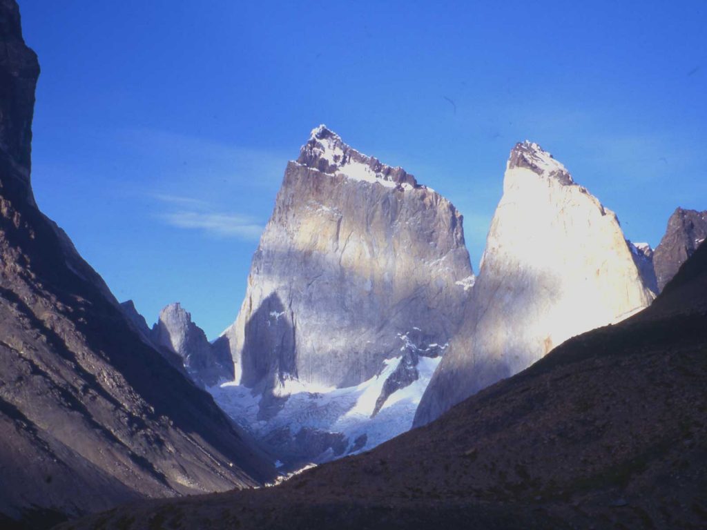
31. Climbing up the glacier above Camp Japenese to the col on the east side of Cerro Oggioni, 1697m. The view ahead is up Valle del Silencio. To the left are the Torres del Paine, with Torre Central. 2460m and Torre Sur, 2500m, showing and to the right Cerro Fortaleza, 2681m.

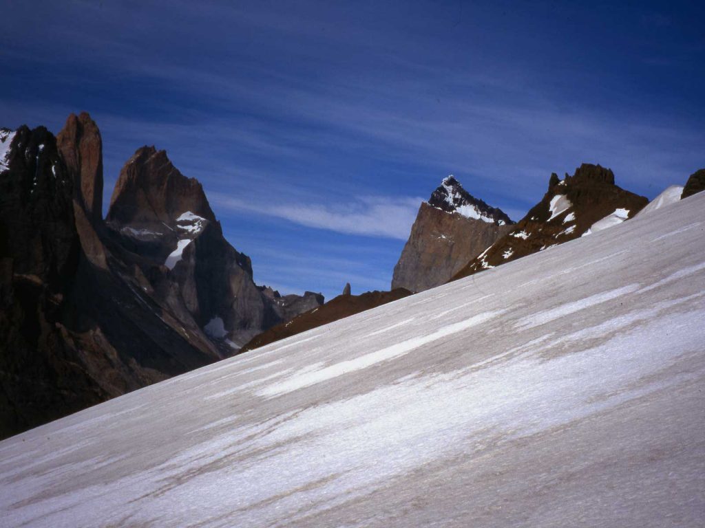
32. Looking east from Paso Oggioni to Cerro Oggioni at the end to the glacier. To the left are the Torres del Paine and Cerro Fortaleza center right. I now descended the slope to the right down to Rifugio Dickson
From here I followed the normal O-Circuit over the John Garner Pass to Lago Grey and onto the Italian Camp and up to Campo Britanico in the Vallee del Frances. I spent the night surreptitiously camping at Campo Britanico and next morning I left the route and went up to the col between Valle del Frances and Valle del Silencio. This col was just on the south side of Cerro Fortaleza. I hoped to find a way down into Valle del Silencio, however there was a precipitous cliff which looked like it would have involved at least 3 rope lengths of abseiling so I had to retreat back down Valle del Frances and join the official route again. To do this now would require special permits.

35. Looking from the notch between Valle del Frances and Valle del Silencio, which lies below. This notch is just to the south of Cerro Fortaleza. However this descent needed a rope to abseil down 3 ropes lengths. So the return was via Valle del Francais